Blog dedicado a cuentos, notas de interés, actividades políticas , sociales, historia, artes culinarias, fiestas patronales, astronomía, ciencia ficción, temas del Medio Ambiente ,y del acontecer Peruano y Mundial desde otro punto de vista muy personal y diferente!!!!!
********** Blog Fundado el 03 de Enero del 2008 **********
Artist’s impression of the Rosetta orbiter at comet
67P/Churyumov–Gerasimenko. (Not to scale.)
Image Credit: NASA/ESA/JPL
Image Token:
Three NASA science instruments are being prepared for check-out operations
aboard the European Space Agency's Rosetta spacecraft, which is set to become
the first to orbit a comet and land a probe on its nucleus in November.
Rosetta was reactivated Jan. 20 after a record 957 days in hibernation. U.S.
mission managers are scheduled to activate their instruments on the spacecraft
in early March and begin science operations with them in August. The instruments
are an ultraviolet imaging spectrograph, a microwave thermometer and a plasma
analyzer.
"U.S. scientists are delighted the Rosetta mission gives us a chance to
examine a comet in a way we've never seen one before -- in orbit around it and
as it kicks up in activity," said Claudia Alexander, Rosetta's U.S. project
scientist at NASA's Jet Propulsion Laboratory (JPL) in Pasadena, Calif. "The
NASA suite of instruments will provide puzzle pieces the Rosetta science team
as a whole will put together with the other pieces to paint a portrait of how a
comet works and what it's made of."
Rosetta’s objective is to observe the comet 67P/Churyumov-Gerasimenko up
close. By examining the full composition of the comet's nucleus, and the ways in
which a comet changes, Rosetta will help scientists learn more about the origin
and evolution of our solar system and the role comets may have played in seeding
Earth with water, and perhaps even life.
The ultraviolet imaging spectrograph, called Alice, will analyze gases in the
tail of the comet, as well as the coma, the fuzzy envelope around the nucleus of
the comet. The coma develops as a comet approaches the sun. Alice also will
measure the rate at which the comet produces water, carbon monoxide and carbon
dioxide. These measurements will provide valuable information about the surface
composition of the nucleus. The instrument also will measure the amount of argon
present, an important clue about the temperature of the solar system at the time
the comet's nucleus originally formed more than 4.6 billion years ago.
The Microwave Instrument for Rosetta Orbiter will identify chemicals on or
near the comet's surface and measure the temperature of the chemicals and the
dust and ice jetting out from the comet. The instrument also will see the
gaseous activity in the tail through coma.
The Ion and Electron Sensor is part of a suite of five instruments to analyze
the plasma environment of the comet, particularly the coma. The instrument will
measure the charged particles in the sun’s outer atmosphere, or solar wind, as
they interact with the gas flowing out from the comet while Rosetta is drawing
nearer to the comet's nucleus.
NASA also provided part of the electronics package the Double Focusing Mass
Spectrometer, which is part of the Swiss-built Rosetta Orbiter Spectrometer for
Ion and Neutral Analysis (ROSINA) instrument. ROSINA will be the first
instrument with sufficient resolution to separate two molecules with
approximately the same mass: molecular nitrogen and carbon monoxide. Clear
identification of nitrogen will help scientists understand conditions at the
time the solar system was born.
U.S. science investigators are partnering on several non-U.S. instruments and
are involved in seven of the mission's 21 instrument collaborations. NASA has an
American interdisciplinary scientist involved in the research. NASA's Deep Space
Network (DSN) is supporting the European Space Agency's (ESA's) Ground Station
Network for spacecraft tracking and navigation.
Rosetta, composed of an orbiter and lander, is flying beyond the main
asteroid belt. Its lander will obtain the first images taken from the surface of
a comet, and it will provide the first analysis of a comet's composition by
drilling into the surface. Rosetta also will be the first spacecraft to witness,
at close proximity, how a comet changes as it is subjected to the increasing
intensity of the sun’s radiation.
The potential research and data from the Rosetta mission could help inform
NASA's asteroid initiative -- a mission to identify, capture and relocate an
asteroid for astronauts to explore. The initiative represents an unprecedented
technological feat that will lead to new scientific discoveries and
technological capabilities that will help protect our home planet and achieve
the goal of sending humans to an asteroid by 2025.
"Future robotic and human exploration missions to Mars, an asteroid and
beyond will be accomplished via international partnerships combining worldwide
scientific and engineering expertise," said Jim Green, director of NASA's
Planetary Science Division in Washington. “Rosetta will provide an opportunity
to study a small new world that could inform us on the best ways to approach,
orbit, and capture our target asteroid for a future human mission.”
The solar-powered spacecraft was placed into a deep sleep in June 2011, to
conserve energy during the portion of its trajectory that carried it past the
orbit of Jupiter. During Rosetta's hibernation, all instruments and subsystems
were shut off, except for the main computer including a spacecraft clock and a
few heaters. ESA mission managers are beginning to commission the spacecraft and
its instruments.
"The successful wake-up of Rosetta from its long, lonely slumber is a
testament to the teams that built and operate the spacecraft, and the
international cooperation between ESA and NASA ensured that we had some of the
world's largest deep space dishes available to relay the first signal back to
Earth," said Mark McCaughrean, senior scientific advisor in ESA's Directorate of
Science and Robotic Exploration. "There is still a lot of work ahead of us
before the exciting comet rendezvous, escort, and landing phase, but it's great
to be back online."
ESA member states and NASA contributed to the Rosetta mission. Airbus Defense
and Space built the Rosetta spacecraft. JPL manages the US contribution of the
Rosetta mission for NASA's Science Mission Directorate in Washington. JPL also
built the Microwave Instrument for the Rosetta Orbiter and hosts its principal
investigator, Samuel Gulkis. The Southwest Research Institute in San Antonio
developed the Rosetta orbiter's Ion and Electron Sensor (IES) and hosts its
principal investigator, James Burch. The Southwest Research Institute in
Boulder, Colo., developed the Alice instrument and hosts its principal
investigator, Alan Stern.
An audio replay of a media teleconference held Friday with NASA and ESA
officials discussing the mission is available until Jan. 31. The call in number
is 800-839-2235.
Scientists ask: If this happened, what then, in ecosystems around the world
Winter at NSF's Harvard Forest LTER site, where future scenarios studies are taking place. Credit and Larger Version
January 28, 2014
Like all of us, scientists think in scenarios: If this happened, what then?
Results of their efforts to understand and anticipate global environmental changes through the process of scenario thinking and ecological forecasting are the topic of the annual National Science Foundation (NSF) Long-Term Ecological Research (LTER) Mini-Symposium.
The forum will be held on Friday, Feb. 21, 2014, at NSF headquarters in Arlington, Va.
Presentations will address social and ecological change; ecosystem vulnerability, resilience and adaptability; and why long-term data are essential to understanding and predicting future responses to natural and human-caused environmental changes.
Results from scenario-thinking and simulations will be presented for ecosystems from forests to lakes to the open ocean.
For example, the Harvard Forest LTER site scenarios project integrates stakeholder engagement with land use and ecosystem modeling. LTER scientists are working to understand the reasons for and consequences of land use change in New England forests and how decisions are made for the forests' future.
Harvard Forest is one of 25 such NSF LTER sites around the world in ecosystems from deserts to grasslands, coral reefs to Arctic tundra.
Another talk at the mini-symposium will describe scenarios for long-term change in a southern Wisconsin watershed, part of the North Temperate Lakes LTER site. The scenarios will be presented as narratives, art and trajectories and maps of environmental factors.
Central Arizona-Phoenix LTER site scientists use "participatory modeling" in their research. The models engage researchers and decision-makers as partners in addressing city planning needs. Results of these efforts will be presented at the forum.
Building on long-term research at the California Current Ecosystem LTER site, models are being developed to better understand changes in fish and other marine species that live in or migrate along the California Current. Findings will be reported at the mini-symposium.
Other presentations will address research at the Hubbard Brook LTER site on the recovery of acid lakes in the Northeast, and climate change in northern Alaska at the Arctic LTER site.
Who:
NSF LTER Network Scientists
What:
NSF LTER Annual Mini-Symposium
When:
Friday, Feb. 21, 2014, 8:30 a.m. - 12:00 p.m.
Where:
National Science Foundation,
Stafford II, Room 555
4201 Wilson Boulevard, Arlington, VA 22230
Detailed Agenda: Scenarios and Ecosystem Forecasting Mini-Symposium
8:30 a.m.
Welcome and Opening CommentsSaran Twombly (NSF Division of Environmental Biology), Scott Collins (University of New Mexico and Sevilleta LTER site) and David Foster (Harvard University and Harvard Forest LTER site)
8:45 a.m.
A Long View: Integrating Stories, Art, and Biophysical Models to Explore Long-term Change in the Yahara Watershed, WisconsinStephen Carpenter (University of Wisconsin and North Temperate Lakes LTER site)
9:15 a.m.
Sustainable Futures ScenariosDavid Iwaniec (Arizona State University and Central Arizona-Phoenix LTER site)
9:45 a.m.
Land Use Scenarios, Ecosystem Services, and Links to Society: A New England Case StudyKathy Lambert (Harvard University and Harvard Forest LTER site)
10:15 a.m.
Break
10:30 a.m.
Recovery of Acid Lakes in the Adirondack Region of New York: Model Projections under Different Scenarios of Emissions ControlsCharles Driscoll (Syracuse University and Hubbard Brook Forest LTER site)
11:00 a.m.
Fire and Ice: Climate Change and Changing Disturbance Regimes in Northern AlaskaGaius Shaver (Marine Biological Laboratory and Arctic LTER site)
11:30 a.m.
Ocean Ecosystems: Forecasting Responses to Climate ForcingEmanuele DiLorenzo (Georgia Institute of Technology and California Current Ecosystem LTER site)
-NSF-
Media Contacts Cheryl Dybas, NSF, (703) 292-7734, cdybas@nsf.gov
Related WebsitesNSF LTER Network: http://www.lternet.edu
NSF Publication: Discoveries in Long-Term Ecological Research:
The National Science Foundation (NSF) is an independent federal agency that supports fundamental research and education across all fields of science and engineering. In fiscal year (FY) 2012, its budget was $7.0 billion. NSF funds reach all 50 states through grants to nearly 2,000 colleges, universities and other institutions. Each year, NSF receives about 50,000 competitive requests for funding, and makes about 11,500 new funding awards. NSF also awards about $593 million in professional and service contracts yearly.
Recovery of acid lakes in the Northeast: A topic at the annual NSF LTER symposium. Credit and Larger Version
Scientists at NSF's Central Arizona-Phoenix LTER site are researching sustainable future scenarios. Credit and Larger Version
Forecasting ocean ecosystem responses to climate change is on the agenda at the symposium. Credit and Larger Version
Forum topic: Integrating stories, art and biophysical models in the Yahara Watershed, Wisconsin. Credit and Larger Version
Research in the far North: Long-term studies at NSF's Arctic LTER site will be discussed. Credit and Larger Version
In this new Hubble image two objects are clearly visible, shining brightly.
When they were first discovered in 1979, they were thought to be separate
objects — however, astronomers soon realized that these twins are a little too
identical! They are close together, lie at the same distance from us, and have
surprisingly similar properties. The reason they are so similar is not some
bizarre coincidence; they are in fact the same object.
These cosmic doppelgangers make up a double quasar known as QSO 0957+561,
also known as the "Twin Quasar," which lies just under 14 billion light-years
from Earth. Quasars are the intensely powerful centers of distant galaxies. So,
why are we seeing this quasar twice?
Some 4 billion light-years from Earth — and directly in our line of sight —
is the huge galaxy YGKOW G1. This galaxy was the first ever observed
gravitational lens, an object with a mass so great that it can bend the light
from objects lying behind it. This phenomenon not only allows us to see objects
that would otherwise be too remote, in cases like this it also allows us to see
them twice over.
Along with the cluster of galaxies in which it resides, YGKOW G1 exerts an
enormous gravitational force. This doesn't just affect the galaxy's shape, the
stars that it forms, and the objects around it — it affects the very space it
sits in, warping and bending the environment and producing bizarre effects, such
as this quasar double image.
The first detection of gravitational lensing meant more than just the
discovery of an impressive optical illusion allowing telescopes like Hubble to
effectively see behind an intervening galaxy. It was evidence for Einstein's
theory of general relativity. This theory had identified gravitational lensing
as one of its only observable effects, but until the observation of these quasar
"twins," no such lensing had been observed since the idea was first mooted in
1936.
Cloud Bands Over the Western Sahara Desert, Mauritania
This photograph of cloud bands over southern Mauritania was taken from the
International Space Station with an oblique angle such that the cloud shadows
are a prominent part of the view. Beneath the clouds, the plateau of dark
sedimentary rocks appears as a ragged, near-vertical escarpment (image top
right). Isolated remnants of the plateau appear as dark mesas (flat-topped
hills) across the top and near the center of the image. The escarpment is about
250 meters high, with a field of orange-colored dunes at the base (image upper
right).
Prevailing winds in this part of the Sahara Desert blow from the northeast.
(Note that north is to the right.) The wavy dunes are aligned transverse
(roughly right angles) to these winds. The sand that makes the dunes is blown in
from a zone immediately upwind (just out of the bottom of the image), where dry
river beds and dry lakes provide large quantities of mobile sand. This pattern
is typical in the western Sahara Desert, where plateau surfaces are mostly dune
free and dune fields are located in the surrounding lowlands. Larger rivers
deposit sandy sediment on the few occasions when they flow, sometimes only once
in decades.
Astronaut photograph ISS038-E-26862 was acquired on Jan. 8, 2014, with a
Nikon D3S digital camera using a 180 millimeter lens, and is provided by the ISS
Crew Earth Observations experiment and Image Science & Analysis Laboratory,
Johnson Space Center. The image was taken by the Expedition 38 crew. It has been
cropped and enhanced to improve contrast, and lens artifacts have been
removed.
NASA's Soil Moisture Active Passive (SMAP) mission will track Earth's water
into one of its last hiding places: the soil. Soil moisture data from SMAP will
aid in predictions of agricultural productivity, weather and climate.
High-resolution global maps of soil moisture produced from SMAP data will inform
water resource management decisions on water availability around our planet.
SMAP is scheduled to launch in November 2014 from Vandenberg Air Force Base,
Calif., on a Delta II rocket. The mission is managed by NASA's Jet Propulsion
Laboratory in Pasadena, Calif.
Image Credit: NASA
NASA, JAXA Prepare Rain and Snow Satellite for Launch
The world enters a new era of global weather observing and climate science in
February with the launch of the Global Precipitation Measurement (GPM) Core
Observatory, a new international science satellite built by NASA.
GPM, a joint mission between NASA and the Japan Aerospace Exploration Agency
(JAXA), is scheduled to launch Feb. 27 from Tanegashima Space Center in Japan.
The observatory will link data from a constellation of current and planned
satellites to produce next-generation global measurements of rainfall and
snowfall from space.
The GPM mission is the first coordinated international satellite network to
provide near real-time observations of rain and snow every three hours anywhere
on the globe. The GPM Core Observatory anchors this network by providing
observations on all types of precipitation. The observatory's data acts as the
measuring stick by which partner observations can be combined into a unified
data set. The data will be used by scientists to study climate change,
freshwater resources, floods and droughts, and hurricane formation and
tracking.
“The water-cycle, so familiar to all school-age young scientists, is one of
the most interesting, dynamic, and important elements in our studies of the
Earth’s weather and climate,” said John Grunsfeld, associate administrator for
NASA's Science Mission Directorate in Washington. “GPM will provide scientists
and forecasters critical information to help us understand and cope with future
extreme weather events and fresh water resources."
The GPM Core Observatory will fly 253 miles (407 kilometers) above Earth in
an orbit inclined 65-degrees to the equator. This orbit allows the Core
Observatory to observe precipitation from the Arctic Circle to the Antarctic
Circle at different times of day so it is able to observe changing storm and
weather systems that behave differently during day and night. Normal operations
will begin about 60 days after launch. Data will be downlinked through NASA's
Tracking and Data Relay Satellite System to the agency's Goddard Space Flight
Center's Precipitation Processing Center in Greenbelt, Md., where it will be
processed and distributed over the Internet.
GPM's Core Observatory carries two instruments to measure rain and snowfall:
the Dual-frequency Precipitation Radar (DPR), designed by JAXA and the National
Institute of Information and Communications Technology in Japan, and built by
NEC Toshiba Space Systems Ltd., Tokyo; and the GPM Microwave Imager (GMI),
provided by NASA and built by Ball Aerospace & Technologies Corp. in
Boulder, Colo. Together, these two instruments will collect improved
observations that will allow scientists to better "see" inside clouds. In
particular, they both provide new capabilities for observing smaller particles
of rain, ice and snow.
"Knowledge of how water moves around the Earth system through precipitation
is vital for monitoring freshwater resources," said Gail Skofronick-Jackson, GPM
project scientist at Goddard. "The data from the GPM mission provides
unprecedented measurements of global precipitation. The GPM Core Observatory
will observe detailed characteristics of rain and snow systems that are also
extremely important for improving weather and climate forecasts."
The DPR precipitation radar adds a new frequency with which to observe
precipitation, allowing it to capture ice and light rain. It will return
three-dimensional profiles and intensities of liquid and solid precipitation
that will reveal the internal structure of storms within and below clouds.
The GMI is a microwave radiometer designed to sense the total precipitation
within all cloud layers. In addition to collecting data on heavy to moderate
rain, four new channels will be sensitive to light rain and snowfall, two types
of precipitation that are especially prevalent in mountain regions and the
higher latitudes over North America, Europe and Asia.
Together, DPR and GMI will provide observations on the size, intensity and
distribution of raindrops and snowflakes. Scientists will be able to use this
data to look at how precipitation behaves and influences weather and climate
patterns. These patterns affect the distribution of fresh water around the
world, impacting supplies for drinking water and agriculture.
The GPM Core Observatory, built by Goddard, will launch on an H-IIA rocket
provided by JAXA. Mitsubishi Heavy Industries Ltd. is managing the launch.
GPM Core Observatory is the latest mission to support NASA's mission to
monitor Earth's vital signs from land, air and space with a fleet of satellites
and airborne and ground-based observation campaigns. NASA develops new ways to
observe and study Earth's interconnected natural systems with long-term data
records and computer analysis tools to better see how our planet is changing.
The agency shares this unique knowledge with the global community and works with
institutions in the United States and around the world that contribute to
understanding and protecting our home planet.
For more information about NASA's Earth science activities in 2014,
visit:
NASA has created a unique spherical film showing water's journey and
extensive impact as it cycles through Earth. "Water Falls," created in
partnership with the Global Precipitation Measurement mission, will premiere
this month on spherical movie screens at special events hosted by The Wild
Center in Tupper Lake, N.Y., and The Space Foundation in Colorado Springs, Colo.
Shortly afterwards it will be released to more than 100 Science On a Sphere
venues worldwide starting Jan. 31, 2014.
Youtube Override:
Designed specifically for spherical screens, "Water
Falls" abstracts the complex mechanics of the GPM mission, and explores the
diversity of phenomena inherent to the water cycle.
NASA's Goddard Space Flight Center in Greenbelt, Md., produced the
nine-minute film specifically for the Science On a Sphere media platform, a
video technology that enables moving images to be wrapped around a 50-pound,
hollow, round screen. The film will play at Goddard's Visitor Center, located
off ICESat Road in Greenbelt, starting on Jan. 31, 2014.
"Water Falls" highlights water's role on Earth as a precious resource that
impacts climate, weather, agriculture, urban sustainability and the natural
world. The film also tells the story of an ambitious space-based research
initiative called the Global Precipitation Measurement mission, or GPM. On Feb.
27, 2014, NASA and the Japan Aerospace Exploration Agency will launch the GPM
Core Observatory that will provide worldwide precipitation measurements every
three hours to help scientists understand how freshwater circulates on
Earth.
"Water Falls" promotional poster.
Image Credit: NASA's Goddard Space Flight
Center
Image Token:
"The goal of the GPM mission is to better understand the intensity,
distribution and amount of rain and snow we have around the world," said Dalia
Kirschbaum, GPM applications scientist and education and public outreach
coordinator at Goddard. "'Water Falls' explores the important concepts of
freshwater on Earth as being a source of life, a cycle constantly in motion and
a cause for disasters."
Through use of animation, data visualizations and videography designed
exclusively for playback on spherical screens, "Water Falls" is designed to
engage science museum visitors.
"For telling a story about studying our whole planet, there's a poetic logic
to designing it for a spherical screen," said Michael Starobin, the film's
producer at Goddard. "Considering the network of orbiting satellites in the GPM
fleet, it's a great thrill to bring it to life with a seemingly endless canvas."
Starobin has produced several Science On a Sphere shows, such as "Loop,"
"Frozen" and "Footprints."
Created by NOAA to display educational, planet-wide data, Science On a Sphere
involves a six-foot-diameter carbon fiber sphere that hangs in the center of a
dark theater, surrounded by four projectors. Connected to a computer system, the
projectors cast images on the circular screen to produce one cohesive picture.
The audience surrounds the sphere to watch as the film appears to float before
their eyes.
"'Water Falls' sets a new standard for spherical filmmaking, and it presents
to mainstream audiences the science and substance of GPM in artistic and
approachable ways," Starobin said.
Tracking and Data Relay Satellite Ready For Launch From
Cape Canaveral
A United Launch Alliance Atlas V rocket with NASA's Tracking and Data Relay
Satellite (TDRS-L) spacecraft on board arrives at the launch pad at Cape
Canaveral Air Force Station's Launch Complex 41. Liftoff is scheduled for
Thursday, Jan. 23 at 9:05 p.m. EST, the opening of a 40-minute launch window.
Live coverage on NASA TV begins at 6:30 p.m.
The TDRS-L spacecraft is the second of three new satellites designed to
ensure vital operational continuity for NASA by expanding the lifespan of the
Tracking and Data Relay Satellite System (TDRSS) fleet, which consists of eight
satellites in geosynchronous orbit. The spacecraft provide tracking, telemetry,
command and high bandwidth data return services for numerous science and human
exploration missions orbiting Earth. These include NASA's Hubble Space Telescope
and the International Space Station. TDRS-L has a high-performance solar panel
designed for more spacecraft power to meet the growing S-band communications
requirements. TDRSS is one of NASA's three Space Communications and Navigation
(SCaN) networks providing space communications to NASA missions.
For the first time in more than a decade, five NASA Earth science missions
will be launched into space in the same year, opening new and improved remote
eyes to monitor our changing planet.
The five launches, including two to the International Space Station (ISS),
are part of an active year for NASA Earth science researchers, who also will
conduct airborne campaigns to the poles and hurricanes, develop advanced sensor
technologies, and use satellite data and analytical tools to improve natural
hazard and climate change preparedness.
The first new NASA Earth science mission of 2014 is
the Global Precipitation Measurement (GPM) Core Observatory, a joint
international project with the Japan Aerospace Exploration Agency (JAXA). Launch
is scheduled for Feb. 27 from Japan.
Image Credit: NASA
Image Token:
NASA
satellites, aircraft, and research help scientists and policymakers find answers
to critical challenges facing our planet, including climate change, sea level
rise, decreasing availability of fresh water, and extreme weather events.
"As NASA prepares for future missions to an asteroid and Mars, we’re focused
on Earth right now," said NASA Administrator Charles Bolden. "With five new
missions set to launch in 2014, this really is shaping up to be the year of the
Earth, and this focus on our home planet will make a significant difference in
people’s lives around the world."
The Orbiting Carbon Observatory (OCO)-2, set to
launch in July, will make precise, global measurements of carbon dioxide, the
greenhouse gas that is the largest human-generated contributor to global
warming.
Image Credit: NASA
Image Token:
The first
NASA Earth science mission of 2014 is the Global Precipitation Measurement (GPM)
Core Observatory, a joint satellite project with the Japan Aerospace Exploration
Agency (JAXA). The mission inaugurates an unprecedented international satellite
constellation that will produce the first nearly global observations of rainfall
and snowfall. This new information will help answer questions about our planet's
life-sustaining water cycle, and improve water resource management and weather
forecasting.
The GPM Core Observatory is scheduled to launch on Feb. 27 from JAXA's
Tanegashima Space Center on a Japanese H-IIA rocket. The spacecraft was built at
NASA's Goddard Space Flight Center, Greenbelt, Md.
In July, NASA will launch a mission to advance our understanding of carbon
dioxide's role in climate change. The Orbiting Carbon Observatory (OCO)-2, a
replacement for a mission lost after a launch vehicle failure in 2009, will make
precise, global measurements of carbon dioxide, the greenhouse gas that is the
largest human-generated contributor to global warming. OCO-2 observations will
be used to improve understanding of the natural and human-induced sources of
carbon dioxide and how these emissions cycle through Earth's oceans, land and
atmosphere.
NASA's Soil Moisture Active Passive (SMAP) mission
will track Earth's water into one of its last hiding places: the soil. SMAP soil
moisture data will aid in predictions of agricultural productivity, weather and
climate. SMAP is scheduled to launch in November.
Image Credit: NASA
Image Token:
OCO-2,
managed by NASA's Jet Propulsion Laboratory (JPL) in Pasadena, Calif., will
launch from Vandenberg Air Force Base, Calif., on a Delta II rocket.
With the November launch of NASA's Soil Moisture Active Passive (SMAP)
mission, NASA will track Earth's water into one of its last hiding places: the
soil. SMAP will map Earth's soil moisture, and provide precise indications of
the soil's freeze-thaw state, to improve understanding of the cycling of water,
energy, and carbon. High-resolution global maps of soil moisture produced from
SMAP data will inform water resource management decisions on water availability
around our planet. SMAP data also will aid in predictions of plant growth and
agricultural productivity, weather and climate forecasts, and monitoring floods
and droughts.
The first of two 2014 Earth science missions to the
International Space Station, ISS-RapidScat will extend the data record of ocean
winds around the globe, a key factor in climate research and weather
forecasting. ISS-Rapidscat is set to launch in June.
Image Credit: NASA
Image Token:
SMAP will
launch from Vandenberg onboard a Delta II rocket. JPL manages the mission.
"On our home planet Earth, water is an essential requirement for life and for
most human activities. We must understand the details of how water moves within
and between the atmosphere, the oceans, and the land if we are to predict
changes to our climate and the availability of water resources," said Michael
Freilich, director of NASA's Earth Science Division in Washington. "Coupled with
data from other ongoing NASA missions that measure sea-surface salinity and that
detect changes in underground aquifer levels, with GPM and SMAP we will have
unprecedented measurements of our planet's vital water cycle."
The Cloud-Aerosol Transport System (CATS)
instrument shown here uses three-wavelength lasers to extend satellite
observations of small particles in the atmosphere. CATS is scheduled to launch
in September on a SpaceX ISS commercial resupply flight.
Image Credit: NASA
Image Token:
Two Earth
science missions will be sent to the International Space Station this year to
measure ocean winds, clouds, and aerosols, marking NASA's first use of the
orbiting laboratory as a 24/7 Earth-observing platform. The new instruments are
the first of a series that will observe Earth routinely from the orbiting
laboratory.
The space station has served as a unique platform advancing scientific
research and technological discovery for more than 13 years. Its mid-inclination
orbit allows for observations at all local times over nearly 85 percent of
Earth's surface. NASA plans to launch five Earth-observing instruments to the
ISS through 2017. These missions are developed and operated jointly by the
International Space Station Program and the Earth Science Division.
ISS-RapidScat, scheduled to launch to the station June 6, will extend the
data record of ocean winds around the globe. These data are a key factor in
climate research, weather and marine forecasting, and tracking of storms and
hurricanes. Using inherited, repurposed hardware, ISS-RapidScat will provide
high-value science at a fraction of the typical cost of developing a free-flying
satellite. ISS-Rapidscat will fly to the station aboard a SpaceX Falcon 9 rocket
and Dragon cargo spacecraft from Cape Canaveral Air Force Station, Fla., on a
commercial resupply flight for the ISS.
NASA's Global Hawk (pictured here) and a fleet of
aircraft equipped with sophisticated sensors will fly 12 NASA campaigns around
the world in 2014. From Antarctica to the Arctic, airborne scientists will study
polar ice sheets, urban air pollution, hurricanes and more.
Image Credit: NASA/Tony Landis
Image Token:
The new
Cloud-Aerosol Transport System (CATS) is a technology demonstration mission
using three-wavelength lasers to extend satellite observations of small
particles in the atmosphere from volcanoes, air pollution, dust, and smoke.
These aerosol particles pose human health risks at ground level and influence
global climate through their impact on cloud cover and solar radiation in
Earth's atmosphere. CATS is scheduled to launch Sept. 12 on another SpaceX ISS
commercial resupply flight from Cape Canaveral Air Force Station.
"With these two instruments launching to the space station, ISS will come
into its own as an important platform for studying the Earth system and global
change," said Julie Robinson, space station chief scientist at NASA's Johnson
Space Center in Houston. "This is just the beginning of the space station
becoming a part of the global Earth-observing network."
NASA also uses a wide array of research aircraft equipped with sophisticated
sensors to advance Earth science research. This year, NASA is sponsoring 12
flight campaigns that will study the polar ice sheets, urban air pollution,
hurricanes, ecosystem health and more over the United States, Central and South
America, Antarctica, and the Arctic Circle.
Putting satellite data to work meeting local and regional needs around the
world is another part of NASA's Earth science mission. In 2014, projects
sponsored by the NASA Applied Sciences Program will tackle ecosystem issues in
the Gulf of Mexico, water scarcity in the U.S. Southwest, and flood management
in the Mekong River delta.
NASA continues to push the boundaries of current technologies to find new
ways to see our complex planet in more detail and with greater accuracy. This
year, NASA's Earth Science Technology Office will test new sensors to improve
measurements of water levels in lakes and reservoirs, carbon dioxide,
terrestrial ecosystems, and natural hazards such as earthquakes and
tsunamis.
NASA monitors Earth's vital signs from land, air and space with a fleet of
satellites and ambitious airborne and ground-based observation campaigns. NASA
develops new ways to observe and study Earth's interconnected natural systems
with long-term data records and computer analysis tools to better see how our
planet is changing. The agency shares this unique knowledge with the global
community and works with institutions in the United States and around the world
that contribute to understanding and protecting our home planet.
For more information about NASA's Earth science activities in 2014,
visit:
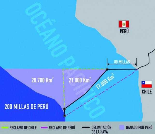
Hola amigos: A VUELO DE UN QUINDE EL BLOG., después de largos 6 años desde que se presentó la demanda a la Corte Internacional de La Haya en Holanda, hoy día 27 de Enero de 2014, tomándose como un hecho histórico en las relaciones con nuestro vecino del sur Chile, si dio el fallo que a nuestro entender es una "Victoria Pírrica" para el Perú, por que la Corte toma como referencia el Hito No1 y no el punto de referencia Concordia desde el mismo nivel del mar, y se proyecta 80 millas mar adentro y desde allí proyecta un corte hacia el pretendido Mar de Chile, formando un triángulo obtuso con aproximadamente 21,000 kilómetros cuadrados que pasaron a dominio peruano.
En realidad viendo como una proyección de ambos países, Chile sale como ganador, por que no le afecta su mar desde la misma playa, ellos no pierden nada, Arica conserva su mar y Tacna no logró nada.
Seguramente en los próximos días la misma Corte Internacional de Justicia, aclarará los alcances de su fallo, para que se ejecute con acuerdo de ambos países,
En su sentencia sobre la controversia marítima entre Perú y Chile, la Corte de La Haya aclaró que ha definido el curso de la frontera marítima entre ambos países sin determinar las coordenadas geográficas. Información de RPP Noticias.
En su sentencia sobre la controversia marítima entre Perú y Chile, la Corte Internacional de Justicia (CIJ) de La Haya aclaró que ha definido el curso de la frontera marítima entre ambos países sin determinar las coordenadas geográficas.
"La corte espera que las partes determinarán estas coordenadas de acuerdo con el fallo actual, en espíritu de buena vecindad", subrayó el presidente del tribunal internacional, Peter Tromka, al dar lectura del fallo.
Luego de más de dos horas de lectura, se dio a conocer el veredicto inapelable y de cumplimiento obligatorio sobre la controversia por los límites marítimos entre Perú y Chile.
"La corte establece que la frontera sigue una línea paralela (...) hasta las ochenta millas y a partir de ahí adquiere una dirección sur hasta un punto B, bajando (en línea recta y a la altura de las 200 millas) hasta un punto C", dijo el magistrado Tomka.
1. "Por 15 votos a 1 la corte decide que el punto de inicio de la frontera marítima es la intersección del paralelo de latitud que pasa por el Hito N°1 con la línea de marea baja".
2. "Por 15 votos a 1 decide que el segmento inicial de la frontera marítima única sigue en dirección oeste, el paralelo de latitud que pasa por el Hito N°1".
3. "Por 10 votos a 6 decide que dicho segmento inicial se extiende hasta un punto A situado a una distancia de 80 millas marinas del punto de inicio de la frontera marítima única".
4. "Por 10 votos a 6 decide que a partir del punto A la frontera marítima única continuará en dirección suroeste siguiendo la línea equidistante entre las costas de las repúblicas del Perú y Chile calculada desde dicho punto hasta su intersección en el punto B, con el límite de las 200 millas marinas...".
5. La corte se declaró incompetente en la petición peruana respecto a la solicitud de revisar el triángulo exterior de mar internacional. "No corresponde que la Corte se refiera", argumentó.
Perú presentó en enero del 2008 una demanda ante la Corte Internacional de Justicia (CIJ) de La Haya en la que sostuvo que la frontera marítima con Chile aún no estaba fijada en un tratado de límites; mientras que Santiago apelaba a los acuerdos pesqueros de 1952 y 1954 para alegar que la línea divisoria ya se encuentra definida.
Las dos naciones culminaron en diciembre de 2012 la etapa oral del contencioso jurídico que mantienen en el tribunal internacional.
En la demanda, el Perú solicitó determinar el curso del límite marítimo de conformidad con el derecho internacional ante la inexistencia de un tratado, precisando que debe iniciarse en el Punto Concordia, punto en que la frontera terrestre llega al mar.
El planteamiento contemplaba el trazado de una línea equidistante a partir de las costas de ambos países a fin de lograr una solución equitativa.
Chile, basándose en la declaración de Santiago de 1952 y el convenio de zona especial fronteriza marítima de 1954, sostuvo que ambos estados acordaron una delimitación marítima que comienza en la costa y continúa a lo largo del paralelo geográfico que pasa por el hito Nº 1.
Conclusiones del fallo de La Haya sobre controversia Perú - Chile| RPP
Wagner: ´Me siento orgulloso y honrado de haber presidido este equipo´| RPP
Wagner: ´Me siento orgulloso y honrado de haber presidido este equipo´
Lunes, 27 de Enero 2014 | 11:50 am
Créditos: AFP
El jefe del equipo jurídico peruano ante La Haya, Allan Wagner, agradeció el apoyo del presidente Ollanta Humala y los expresidentes Alejandro Toledo y Alan García.
Tras la lectura de la sentencia de la Corte Internacional de Justicia Internacional de La Haya, (CIJ) sobre el diferendo marítimo entre Perú y Chile, el jefe del equipo jurídico peruano ante esa instancia, Allan Wagner, agradeció el apoyo del presidente Ollanta Humala y los expresidentes Alejandro Toledo y Alan García.
"A nombre de la delegación peruana, y en el mío propio, agradezco el apoyo del presidente Ollanta Humala y los expresidentes Alejandro Toledo y Alan García, quienes condujeron este proceso como ejemplar política de Estado durante tres gobiernos democráticos", dijo el excanciller.
Asimismo felicitó a la canciller, Eda Rivas y los excancilleres, José Antonio García Belaunde y Rafael Roncagliolo, así como a los juristas nacionales e internacionales que participaron en este proceso por su excelente labor.
Wagner, que también rindió un homenaje a su maestro, Juan Miguel Bákula, diplomático pionero de la demanda peruana contra Chile, dijo sentirse orgulloso del equipo que presidió.
"Me siento orgulloso y honrado de haber presidido un equipo de tan magnífica calidad y patriótica dedicación", manifestó.
Finalmente, indicó que la apreciación oficial peruana sobre el fallo emitido por la CIJ, será dado por el presidente de la República, Ollanta Humala y la canciller Eda Rivas.
Así informó la Agencia de Noticias EFE:
La Corte Internacional de Justicia modifica la frontera Chile-Perú a favor de Lima
Mapa
La Corte Internacional de Justicia modifica la frontera Chile-Perú a favor de Lima
(EFE)–hace 10 horas
La Haya, 27 ene (EFE).- La Corte Internacional de Justicia (CIJ) modificó hoy la frontera marítima entre Chile y Perú en beneficio de Lima, aunque no ajustó las coordenadas precisas ni concedió los reclamos iniciales de la demanda peruana.
"La Corte establece que la frontera sigue una línea paralela (...) hasta las ochenta millas y a partir de ahí adquiere una dirección sur hasta un punto B, bajando (en línea recta y a la altura de las 200 millas) hasta un punto C", dijo el presidente de la CIJ, Peter Tomka.
De este modo, la Corte concede a Perú una porción del mar hasta ahora en manos chilenas, ya que establece una línea de equidistancia hacia el sur a partir de las 80 millas del paralelo 18 grados, 21 minutos, 00 segundos que hasta ahora servía de frontera entre los dos países.
En dos horas de lectura del fallo, los jueces hicieron un largo recorrido por los tratados de 1952 y 1954 que según Chile establecía el citado paralelo como frontera marítima y concluyeron que esa línea paralela solamente se podía mantener hasta la altura de las 80 millas.
Los jueces no han establecido las "coordenadas precisas", algo que piden determinar a las partes: "La corte espera que las partes determinen estas coordenadas de acuerdo con el fallo y en el espíritu de buenos vecinos".
Perú, que en 2008 llevó el caso contra Chile a la CIJ, pidió a ese alto tribunal que delimitase la frontera marítima con su vecino del sur de acuerdo con una línea equidistante, con lo que ganaría unos 35.000 kilómetros cuadrados de aguas en el Pacífico.
El fallo le ha concedido una parte de ese territorio reclamado, pero no en su totalidad.
Chile consideraba que la frontera en el mar pasa por el paralelo 18 grados, 21 minutos, 00 segundos, lo que el Alto Tribunal solamente ha aceptado parcialmente.
Así informó la Agencia Peruana de Noticias Andina:
Fallo de La Haya cierra "un capítulo" de la historia republicana del Perú
Lima, ene. 27 (ANDINA). El fallo de la Corte Internacional de Justicia (CIJ) de La Haya que delimita la frontera marítima con Chile, cierra un capítulo de la historia republicana del Perú que corresponde a la definición de los límites, sostuvo hoy el asesor jurídico de la Cancillería, Juan José Ruda.
Juan josé Ruda asesor juridico del Miniterio de Relaciones Exterior. ANDINA/Vidal Tarqui
"Con esto (el fallo) después de lo que fue el acuerdo de límites marítimos con Ecuador el 2011, cerramos todo lo que ha sido el proceso de fricción de nuestros límites a lo largo de nuestra historia Republicana", subrayó.
La CIJ definió hoy la frontera marítima entre Perú y Chile mediante una línea paralela de 80 millas naúticas a partir del paralelo que atraviesa el hito1, la cual continúa con un trazo equidistante hasta las 200 millas, tras un largo proceso judicial iniciado en 2008.
"Es una gran alegría para el Perú el haber escuchado el fallo de la Corte Internacional de Justicia y haber conseguido efectivamente una victoria en relación a los 50 mil kilómetros cuadrados que la Corte nos ha reconocido", dijo a ATV+.
Advirtió que si bien el fallo de la Corte de La Haya no recoge al 100% lo que el Perú había reivindicado, "sí recoge un porcentaje considerable" al haberse logrado alrededor del 75% de lo solicitado ante el tribunal internacional.
Asimismo, consideró que se logró que la CIJ "reconociera que no existía un límite marítimo como Chile" tal como pretendía que abarcara 200 millas a lo largo del paralelo del hito 1.
"Los 50 mil kilómetros cuadrados que la Corte nos ha reconocido como espacio de derechos soberanos, constituye un área de derechos exclusivos en materia de actividad pesquera y en relación a cualquier recurso vivo o no vivo en el área", señaló.
Precisó que estos recursos pueden estar en la masa de agua, en el suelo o subsuelo marino y a la vez también la CIJ le otorga al Perú capacidad plena para realizar cualquier investigación en esta área.
Fallo de La Haya inicia nueva etapa de desarrollo común con Chile, destaca Gana Perú Lima, ene. 27 (ANDINA). El Grupo Parlamentario Nacionalista Gana Perú expresó hoy su confianza en que tras el fallo de la Corte Internacional de Justicia de La Haya que delimita la frontera marítima con Chile, continúe una fase de desarrollo común con ese país, en un ambiente de paz.
"Tenemos la esperanza de que lo que siga es el inicio de una nueva etapa con Chile, donde se privilegie el desarrollo común de ambos pueblos en un ambiente de paz y de búsqueda de un futuro mejor para sus ciudadanos", señaló en un comunicado.
Añadió que después de revisar la sentencia, se determina que "se ha establecido de manera definitiva y clara el límite marítimo con Chile" y se han reconocido los derechos económicos exclusivos del Perú en "un área adicional", aproximadamente 50,000 km2.
"De esta manera, se modifica parcialmente los límites marítimos basado en el principio de equidistancia, y se ha establecido que el punto de inicio de la frontera marítima entre ambos países será a partir del hito Uno", indica.
"A partir de estos elementos, tenemos razones fundadas para sostener que estamos ante un fallo justo, que si bien no acepta todos nuestros planteamientos, es favorable en lo medular, siendo por ello que peruanos y peruanas debemos darle el máximo significado a este hecho", afirmaron.
Asimismo, esta bancada felicitó a la Cancillería, al equipo jurídico que sustentó la posición peruana, y a los diferentes gobiernos que desarrollaron una política de Estado "tan adecuadamente conducida".
"Saludamos la madurez cívica de todos los poderes del Estado, de los gobiernos regionales y locales, de las fuerzas políticas y de todas las instituciones de la sociedad civil, por la unidad demostrada a lo largo de todo este proceso", añade.
También expresaron un homenaje a los miles de los peruanos que perdieron la vida en defensa de la soberanía y en especial al pueblo de Tacna "que nunca arrió sus banderas de lucha por la justa causa peruana".
EE.UU. felicitó a Perú y Chile por resolución pacífica
Ambos países culminaron hoy un proceso en la corte de La Haya que duró seis años
Las delegaciones del Perú y Chile en el Palacio de la Paz. (Foto: Reuters)
El Gobierno de EE.UU. felicitó hoy a Chile y Perú por resolver pacíficamente su litigio marítimo, y expresó su respeto a la decisión adoptada hoy al respecto por la Corte Internacional de Justicia (CIJ) de La Haya.
"Como amigo y aliado de ambas naciones, felicitamos a Chile y Perú por resolver la disputa pacíficamente", dijo un portavoz del Departamento de Estado de EE.UU., que pidió el anonimato.
"Estados Unidos apoya la resolución pacífica de las disputas marítimas y territoriales, incluido, cuando sea apropiado, su resolución mediante tribunales internacionales", añadió el portavoz.
La CIJ concedió hoy a Perú una parte del mar chileno al recortar a la altura de las 80 millas desde la costa el paralelo que hasta ahora marcaba la frontera marítima entre ambos países y que Perú pretendía que se sustituyera completamente con una línea equidistante.
El máximo órgano judicial de las Naciones Unidas decidió por mayoría que el punto de partida de la delimitación marítima se mantuviera en el llamado "Hito 1", tal y como defendió Chile durante las audiencias.
Al no modificar la división marítima en las primeras 80 millas a partir de la costa, tanto Chile como Perú mantienen invariable su soberanía sobre el área donde se practica la pesca de bajura, de importancia especial por la captura de la anchoveta, una especie que se usa para la fabricación de harinas de las que Perú y Chile son el primer y segundo exportador mundial, respectivamente.
Chile cede espacio marítimo a Perú por el fallo de La Haya
A pesar de la resolución, ambos países seguirán explotando las mismas zonas de pesca El tribunal amplió en 21.000 kilómetros el límite fronterizo de Perú y remarcó que espera que el fallo se acate sin conflictos
ALEGRÍA. El presidente Humala (a la izquierda de corbata) festejó el fallo. | Ampliar (1 de 3 fotos)
LA HAYA.- La Corte Internacional de Justicia (CIJ) concedió ayer a Perú parte del mar en la que hasta ahora Chile ejercía soberanía, al modificar de manera parcial la frontera marítima, pero dejó inalterables los límites en la zona económica de pesca, según el fallo leído en La Haya sobre la demanda peruana.
De una superficie marítima reclamada por Perú de 38.000 kilómetros cuadrados, la CIJ determinó que 21.000 pasarán a la soberanía peruana y 17.000 quedarán como mar chileno, según se desprende de la lectura del fallo -que duró más de dos horas- leído por el presidente del tribunal de las Naciones Unidas, Peter Tomka.
Sin embargo, el fallo, adoptado por 15 votos contra 1, no altera las zonas de pesca en las que Perú y Chile ejercen su exclusividad, principal preocupación de los dos gobiernos y los sectores pesqueros a ambos lados de la frontera, con foco en las ciudades peruana de Tacna y chilena de Arica.
De esta manera, los dos países seguirán explotando en las mismas áreas en que lo hacían hasta ahora la pesca de bajura, es decir las de las proximidades a las costas, de importancia especial por la captura de la anchoveta, usada para la fabricación de harinas de las que Perú y Chile son el primer y segundo exportador mundial, respectivamente.
Esta situación quedó determinada a partir de la CIJ mantuvo el actual límite hasta las 80 millas a partir de la costa, el llamado Hito 1, que es la línea marcada por el paralelo 18 grados, 21 minutos, 00 segundos, el mismo que define la frontera terrestre.
Pero la concesión a Perú de 21.000 kilómetros cuadrados del mar chileno surge porque el tribunal interpretó que, a partir de las 80 millas desde la costa, el límite no debe ser la prolongación del Hito 1, como sostenía Chile, sino una línea equidistante en dirección oeste-sur hasta las 200 millas medidas desde la costa chilena.
La introducción de esta línea equidistante concede además el área marítima más allá de las 200 millas solicitada por Perú, pero mantiene bajo soberanía chilena unos 17.000 kilómetros cuadrados de mar a los que Lima también aspiraba.
Para establecer esta nueva delimitación en el Pacífico, los jueces analizaron los convenios ya existentes y su puesta en práctica, en especial los tratados de 1952 y 1954 en los que se definieron además acuerdos pesqueros entre ambos países.
Los jueces ponderaron el veredicto como una solución que busca ser “equitativa”, aunque reconocieron que la situación es “poco habitual”, ya que debe haber una delimitación en alta mar, porque, aunque esbozaron la línea divisoria, no establecieron las “coordenadas precisas” de esta nueva frontera marítima.
“La Corte espera que las partes determinen estas coordenadas de acuerdo con el fallo y en el espíritu de buenos vecinos”, sostuvo el fallo. (Télam)
El parlamentario indicó que ahora le queda al presidente Ollanta Humala y autoridades correspondientes elaborar una agenda a favor de la región. Temas relacionados: la haya · juan pari · congresista · agenda · Tacna · Nacional. Desde la ciudad de Tacna, ...
Lima, ene. 27 (ANDINA). El fallo de la Corte Internacional de Justicia (CIJ) de La Haya que delimita la frontera marítima con Chile, cierra un capítulo de la historia republicana del Perú que corresponde a la definición de los límites, sostuvo hoy el asesor ...
El Gobierno de EE.UU. felicitó hoy a Chile y Perú por resolver pacíficamente su litigio marítimo, y expresó su respeto a la decisión adoptada hoy al respecto por la Corte Internacional de Justicia (CIJ) de La Haya. "Como amigo y aliado de ambas naciones, ...
El presidente de Perú, Ollanta Humala, se complació con la decisión de la Corte Internacional de Justicia, que reconoció a su país un área de unos 50,000 kilómetros cuadrados de derechos soberanos. Síguenos en redes sociales o comparte esta liga: ...
Funerales. El presidente de Perú, Ollanta Humala, izquierda, acompañado de la primera dama, Nadine Heredia, derecha, mientras habla ante cientos de personas,tras conocer el fallo de la corte. Noticias Relacionadas. Presidente de Perú expresa su ...
“Chile cumplirá y exigirá el cumplimiento del fallo de la Corte de La Haya", reiteró el mandatario. El Presidente Sebastián Piñera afirmó esta noche que el cumplimiento del fallo de la Corte Internacional de Justicia de La Haya será “gradual” y “requerirá ...
La sentencia emitida por la Corte Internacional de La Haya, en la mejor tradición de la conclusión de las negociaciones inteligentes, no dejará contento a nadie, pero tampoco provocará suficiente malestar como para que alguien vaya a desconocer el fallo.
La canciller peruana, Eda Rivas, dijo hoy que el fallo que emitió hoy la Corte Internacional de Justicia (CIJ) sobre los límites marítimos con Chile recoge la "mayoría de las expectativas de Perú" y debe ejecutarse "a la brevedad posible". En una entrevista con ...
LA HAYA.- La Corte Internacional de Justicia (CIJ) concedió ayer a Perú parte del mar en la que hasta ahora Chile ejercía soberanía, al modificar de manera parcial la frontera marítima, pero dejó inalterables los límites en la zona económica de pesca, según ...
PERÚ.- El presidente de Perú, Ollanta Humala, dio ayer un discurso al conocer el resultado del fallo de la Corte de La Haya sobre el diferendo marítimo con Chile. Al inicio de su discurso, dijo que es “un motivo de satisfacción que la corte haya reconocido la ...
Los chilenos recibieron ayer el fallo de la Corte Internacional de Justicia (CIJ) de La Haya de manera pacífica y con notoria indiferencia, dejando de lado toda teoría de posibles protestas y encuentros violentos entre grupos que no acepten el veredicto y ...
Miembros de la Corte Internacional de Justicia (CIJ) durante la emisión del fallo sobre el contencioso marítimo entre Perú y Chile, en la Haya (Holanda). Foto: EFE. El tribunal definió el diferendo limítrofe entre ambas naciones. La Corte Internacional de ...
Esta es la nueva delimitación marítima entre el Perú y Chile.(Infografía: El Comercio / Video: TV Perú). Compartir; 90. La Corte Internacional de Justicia (CIJ) de La Haya modificó hoy la frontera marítima entre Chile y Perú en beneficio de Lima, aunque no ...
Según la canciller Eda Rivas es hora de pensar en el desarrollo especialmente de las ciudades fronterizas. Propuesta incluye construcción de muelles artesanales, carreteras, obras de irrigación, entre otros, anunció Eda Rivas. Foto: larepublica.pe.
Humala Tasso también precisó que el hecho de que la delimitación parta del Hito N°1 “no afecta ni prejuzga la intangibilidad de la frontera terrestre establecida en el Tratado de 1929, que fija su inicio en el punto Concordia". (Foto: Andina). Compartir; 2.
Lima, ene. 27 (ANDINA). El Grupo Parlamentario Nacionalista Gana Perú expresó hoy su confianza en que tras el fallo de la Corte Internacional de Justicia de La Haya que delimita la frontera marítima con Chile, continúe una fase de desarrollo común con ...
Radio Programas del Perú - hace 1 la última hora
El excanciller José Antonio García Belaunde aclaró que la sentencia no pone en duda la frontera terrestre entre Perú y Chile. Temas relacionados: corte internacional de justicia · la haya · diferendo maritimo · fallo · Lima · Política. El coagente del Perú en la ...
SANTIAGO, 27 ene (Xinhua) -- La Corte Internacional de Justicia (CIJ) reconoció hoy a Chile una frontera en paralelo de sólo 80 millas y no las 200 que aspiraba y procedió a quebrar la línea equidistante y establecer una nueva frontera marítima con Perú ...
LIMA, 27 ene (Xinhua) -- Los peruanos esperan en plena unidad la lectura de la sentencia de la Corte Internacional de Justicia de La Haya sobre la controversia marítima con Chile, destacó hoy la canciller peruana, Eda Rivas. Palabras clave:.
La resolución de la Corte Internacional de Justicia de La Haya sobre el conflicto limítrofe entre el Perú y Chile pone punto final a un conflicto secular que no debía permanecer sin resolverse. La tradición de la Corte Internacional garantiza la solidez de la ...
La canciller remarcó que hasta el momento Perú y Chile han actuado de buena fe y deben seguir en esa ruta para cumplir la sentencia. Eda Rivas aseguró que es innecesario crear comisión mixta para ejecutar sentencia Foto: Andina Eda Rivas aseguró ...
Los presidentes de Chile, Sebastián Piñera, y Perú, Ollanta Humala, sostendrán una reunión el próximo miércoles en La Habana, donde ambos coincidirán con motivo de la II Cumbre de la Comunidad de Estados Latinoamericanos y Caribeños (Celac).
La Corte Internacional de Justicia (CIJ) de La Haya resolvió modificar la frontera marítima entre Chile y Perú en una sentencia inapelable que fue recibida como una especie de salida intermedia en la que Lima obtiene menos de lo que quería y Santiago no ...
Sebastián Piñera fue claro en señalar que su país cumplirá el fallo pero que también lo hará cumplir. (Foto: Archivo El Comercio/Video: Canal N). Compartir. El presidente chileno, Sebastián Piñera, explicó hoy en cadena televisiva nacional los principales ...
En una decisión lo más solomónica, la Corte Internacional de Justicia de La Haya aceptó ayer parcialmente correr el límite marítimo entre Chile y Perú en beneficio de este último. La demanda había sido presentada por Lima el 16 de enero de 2008 y fue ...
SANTIAGO, 27 ene (Xinhua) -- La presidenta electa de Chile, Michelle Bachelet, dijo hoy que el fallo de la Corte Internacional de Justicia (CIJ) de La Haya sobre el diferendo marítimo con Perú impacta a la zona económica chilena y es una perdida dolorosa.
La Haya — El fallo de la Corte Internacional de Justicia de La Haya (CIJ) por la frontera marítima entre Perú y Chile cerró un conflicto histórico de 140 años con una decisión que salva el honor de ambos países, estimaron analistas. La nueva demarcación ...
La Haya — La Corte Internacional de Justicia de La Haya (CIJ) otorgó este lunes a Perú una parte del Pacífico que estaba bajo control de Chile, en un fallo histórico que provocó júbilo entre los peruanos. Según un mapa mostrado en la sala, los jueces de la ...
SANTIAGO, 27 ene (Xinhua) -- La Corte Internacional de Justicia (CIJ) dictó hoy un fallo salomónico sobre la demanda marítima de Perú contra Chile, que no dejó contento a ninguno de los dos países vecinos, que han enfrentado problemas fronterizos ...
Alan García dice que aunque Perú no ganó "todo" es un día de satisfacción
(EFE)–hace 10 horas
Lima, 27 ene (EFE).- El expresidente peruano Alan García (1990-2000) consideró que, aunque Perú no logró "todo" lo que quería "ganar", hoy ha sido "un día de reivindicación" y "satisfacción" para su país por el fallo de la Corte Internacional de Justicia (CIJ) de La Haya en el litigio por límites marítimos con Chile.
"Quisiera saludar este como un día de reivindicación en el cual el pueblo peruano puede tener la satisfacción de haber sido escuchado por el máximo tribunal de justicia del mundo", declaró García a los periodistas.
La CIJ determinó hoy en La Haya que la frontera marítima entre Perú y Chile se mantendrá, como hasta ahora, con una línea paralela hasta 80 millas de la frontera y a partir de ahí se proyectará en una línea equidistante hasta las 200 millas, cuyas coordenadas deben ser fijadas por ambos países.
García, que en 2008 presentó la demanda para pedir que la CIJ fijara los límites en el mar con Chile, indicó que todavía no se puede "precisar exactamente cuantos miles de kilómetros cuadrados se incorporan como consecuencia del fallo" al territorio marítimo peruano.
El expresidente saludó a "todos los peruanos en este día de satisfacción", además de "al pueblo de Chile" y al de Ecuador y su presidente, Rafael Correa, con el cual suscribió un tratado de límites marítimos durante su gestión.
"Con la resolución se pone fin a estos últimos temas y nuestros dos pueblos pueden comenzar y continuar por una senda de progreso, desarrollo y paz", acotó.
García admitió, finalmente, que el fallo de la Corte "no es todo" lo que Perú quería "ganar", ya que había pedido que se establezca una línea equidistante desde el Punto Concordia.
"Pero en la vida hay que saber ganar y estar contento", concluyó.
El desenlace del litigio con Perú provoca reacciones dispares en la fronteriza Arica
Mapa
El desenlace del litigio con Perú provoca reacciones dispares en la fronteriza Arica
(EFE)–hace 6 horas
Arica (Chile), 27 ene (EFE).- El desenlace del litigio marítimo entre Chile y Perú conocido hoy mediante el fallo de la Corte Internacional de Justicia de La Haya provocó reacciones dispares entre los pescadores de la ciudad fronteriza de Arica, quienes estiman la decisión adoptada por la CIJ perjudica sus intereses.
"No es menor lo que hemos perdido, pero no es lo que realmente pensábamos que íbamos a perder", declaró Sergio Guerrero, presidente del Sindicato de Pescadores Artesanales de la región de Arica.
Según este dirigente, la mayor parte de la pesca de anchoveta no se verá afectada por la nueva delimitación, aunque los pescadores chilenos deberán renunciar a otras especies que viven en aguas más profundas, como la palometa o el bacalao, que se capturan a entre 60 y 150 millas de la costa.
Los pescadores y otros representantes de organizaciones sociales se congregaron este lunes en el puerto de Arica, ciudad situada a 25 kilómetros de la peruana Tacna y a 2.051 de Santiago, para seguir en directo la lectura del fallo.
Posteriormente varios centenares de personas se manifestaron por las calles de la ciudad para expresar su descontento con la resolución del conflicto.
La protesta finalizó frente a la sede de la Intendencia (Gobernación), donde en esos momentos se encontraba el ministro del Interior, Andrés Chadwick, quien viajó el fin de semana a Arica para entrevistarse con las autoridades locales y con dirigentes sociales.
La policía empleó un carro lanzaagua para dispersar a los manifestantes, según pudo comprobar Efe, y al menos cuatro personas fueron detenidas durante los altercados.
La CIJ, máximo tribunal de las Naciones Unidas, estableció hoy en su fallo sobre la demanda presentada por Perú en enero de 2008 que la frontera está clara hasta las 80 millas y a partir de ese punto aplica la línea equidistante a las costas de ambos países.
Con esta sentencia, que es inapelable y debe ser acatado por las partes, Chile pierde parte de la zona económica exclusiva, aproximadamente unos 22.000 kilómetros cuadrados situados entre las 80 y las 200 millas, pero reconoce que la delimitación es a partir del hito 1, como en la actualidad.
La flota pesquera artesanal chilena, que extrae anchoveta, faena en las aguas comprendidas dentro de la frontera marítima chilena reconocida por La Haya.
La Razón (Edición Impresa) / La Paz 00:03 / 28 de enero de 2014
La sentencia emitida ayer por la Corte Internacional de Justicia (CIJ) respecto al diferendo por el límite marítimo entre Perú y Chile deja al menos dos lecciones que hay que resaltar. El fallo le otorga a Perú aproximadamente 50.000 km2 de mar, más de dos tercios del territorio en disputa. Primera lección, Perú acudió a La Haya porque Chile se negó sistemáticamente a negociar un acuerdo. Si el país trasandino hubiese aceptado negociar directamente, además de los cuantiosos gastos legales, probablemente sus pérdidas territoriales hoy serían menores.
Segunda lección. Los mandatarios de ambos países declararon su predisposición a cumplir la sentencia de la CIJ antes de que sea dictada. Una determinación fundamental para que pueda ponerse en práctica. Esta buena predisposición chilena (Perú no tenía nada que perder) se debe principalmente a las relaciones cada vez más estrechas entre ambos países, sobre todo económicas. Y ese precisamente es el camino que Bolivia debería recorrer para conseguir una salida soberana al pacífico. Es decir, implementar estrategias con bajo perfil y desde diferentes ámbitos (comercial, cultural, ambiental, económico, etc.) que nos acerquen efectivamente al mar, de tal manera que a Chile le resulte un mal negocio negarse a solucionar la reivindicación marítima boliviana.
Semana Mundial del Ahorro en Perú
-
Semana Mundial del Ahorro en Perú “No ahorres lo que te queda después de
gastar, gasta lo que te queda después de ahorrar”, éstas son palabras
sabias del g...
EL CUERPO DE CRISTO
-
#lamentedeCristoelprimerdia
Ef 2: 19 Así que ya no sois extranjeros ni advenedizos, sino conciudadanos
de los santos, y miembros de la familia de Dios.
Fo...


 mission will track Earth's water into one of its last hiding places: the soil.")

 spacecraft on board arrives at the launch pad at Cape Canaveral Air Force Station's Launch Complex 41.")


