Mi lista de blogs

martes, 29 de octubre de 2013

nsf.gov - National Science Foundation - EarthCube: NSF funds $14.5 million in grants to improve geosciences cyberinfrastructure

Awards foster better data accessibility on research topics, from the sun to the center of the Earth 


Illustration showing mulitple Earths in various colors
NSF'S EarthCube awards bring together the geosciences and related fields.
Credit and Larger Version
October 28, 2013
Imagine a world with unlimited access to scientific data in any field, where researchers can plot data from any source and visualize it any way they'd like, and where they can model results and explore ideas from a desktop, a lab or the field.
EarthCube aims to make that vision a reality.
EarthCube is a National Science Foundation (NSF) effort to create a data and knowledge management system for geosciences in the 21st century.
Its objective is to develop new ways of understanding and predicting the Earth system, from the sun to the center of the Earth.
To foster a dialog among geo-, bio- and cyberscientists to create an EarthCube framework, NSF has made 13 new awards totalling $14.5 million.
The effort is sponsored by NSF's Directorate for Geosciences along with its Directorate for Computer and Information Science and Engineering.
"Pushing the frontiers of the geosciences requires innovative ways to connect and share data and information," says Roger Wakimoto, NSF assistant director for Geosciences.
"As the internet revolutionized the way we lead our daily lives, scientists are searching for technologies that will advance the ability to discover, collaborate and conduct research at all levels.
"Through EarthCube, NSF has made investments in these technologies and the infrastructure that will be the foundation of addressing challenges in studying the Earth system."
Scientists who specialize in governance; data discovery, mining and access; workflows and other fields are participating.
We're in an era when access to information and data is often less a problem than the ability to efficiently process and use it, geoscientists say.
In some cases, the problem is caused by huge datasets that are difficult to store, transfer or analyze.
In other cases, the challenge is discovering and aggregating relevant data widely disseminated in many locations and formats, such as in the tables, text and figures of published papers, government agency reports, spreadsheets and websites.
A central EarthCube goal is establishing a computing system that can aid in finding, extracting and aggregating data, as well as in processing, summarizing and synthesizing those data in ways that help geoscientists better understand and model Earth systems.
Illustration showing a hand touching a screen that displays different images EarthCube awards: NSF's directorates for geosciences; computer & information science & engineering.
Credit and Larger Version
Illustration showing a cube with sybols for shells, water and a globe on the facets.
EarthCube brings together geosciences, bioscientists and cyberscientists, engineers and educators.Credit and Larger Version
Illustration showing part of Earth seen from outspace and beam of light connecting places.
Imagine a world with easy access to unlimited scientific data: the goal of EarthCube.
Credit and Larger Version
Illustration showing rows of 0 and 1 intertwined
EarthCube: fostering connectivity among scientific disciplines in the geosciences and beyond.
Credit and Larger Version
Illustration showing a word cloud of the most common Earthcube concepts
The new EarthCube awards are melding geosciences and cyberinfrastructure.
Credit and Larger Version
 
 
2013 NSF EarthCube Awards:
Yolanda Gil, University of Southern California:
Kerstin Lehnert, Columbia University, Lamont Doherty Earth Observatory:
Matty Mookerjee, Sonoma State University:
Wonsuck Kim, University of Texas at Austin:
Tim Ahern, Integrated Research Institutions for Seismology:
Christopher Re, Stanford University:
David Maidment, University of Texas at Austin: EarthCube building blocks: Integrating discrete and continuous data
Siri-Johda Khalsa, University of Colorado:
Scott Peckham, University of Colorado:
Ilya Zaslasky, University of California, San Diego:
David Fulkner, Open Source Project for Network Data Access Protocols:
Thomas Narock, University of Maryland, Baltimore County:
Lee Allison, University of Arizona:
-NSF-

Media Contacts Cheryl Dybas, NSF (703) 292-7734 cdybas@nsf.gov

Related WebsitesNSF EarthCube Program:
http://www.nsf.gov/geo/earthcube/index.jsp
EarthCube: Data and Knowledge Environment for the Geosciences:

The National Science Foundation (NSF) is an independent federal agency that supports fundamental research and education across all fields of science and engineering. In fiscal year (FY) 2012, its budget was $7.0 billion. NSF funds reach all 50 states through grants to nearly 2,000 colleges, universities and other institutions. Each year, NSF receives about 50,000 competitive requests for funding, and makes about 11,500 new funding awards. NSF also awards about $593 million in professional and service contracts yearly.
Useful NSF Web Sites:
NSF Home Page:
 http://www.nsf.gov
NSF News:
http://www.nsf.gov/news/
For the News Media:
http://www.nsf.gov/news/newsroom.jsp
Science and Engineering Statistics:
 http://www.nsf.gov/statistics/
Awards Searches:
 
The National Science Foundation (NSF
Guillermo Gonzalo Sánchez Achutegui

NASA : Supernova Remnant G266.2-1.2


Supernova Remnant G266.2-1.2
G266.2-1.2 was produced by the explosion of a massive star in the Milky Way galaxy. A Chandra observation of this supernova remnant reveals the presence of extremely high-energy particles produced as the shock wave from this explosion expands into interstellar space. In this image, the X-rays from Chandra (purple) have been combined with optical data from the Digitized Sky Survey (red, green, and blue).
Image credit: X-ray: NASA/CXC/Morehead State Univ/T.Pannuti et al, Optical: DSS
NASA
Guillermo Gonzalo Sánchez Achutegui
Inscríbete en el Foro del blog y participa : A Vuelo De Un Quinde - El Foro!

TURQUÍA; Inaugurado el primer túnel debajo del Bósforo que une Europa con Asia, con participación española

The Marmaray Project

Marmaray Project
The Marmaray Project is the upgrading of approximately 76 kilometers of commuter rail from Halkalı to Gebze. The red alignment on the map shows the parts of the railway that are above ground and the white alignment shows the new railway system that will be constructed in tunnels under the Istanbul Strait.

Inaugurado el primer túnel debajo del Bósforo que une Europa con Asia, con participación española
Mapa

Inaugurado el primer túnel debajo del Bósforo que une Europa con Asia, con participación española
(EFE) – hace 3 horas 
Estambul, 29 oct (EFE).- Turquía inauguró hoy el túnel que une Asia con Europa por debajo del Bósforo en Estambul, una obra con una importante participación de empresas españolas, y con la que el país eurasiático conmemora sus 90 años como república.
El túnel, de 13,6 kilómetros de longitud, de ellos 1,4 bajo el mar, supone la primera conexión de ferrocarril entre Europa y Asia al sur de Rusia y que enlaza directamente con el Lejano Oriente a través de Irán.
En la ceremonia de apertura, encabezada por el presidente de Turquía, Abdullah Gül, estuvieron presentes el primer ministro turco, Recep Tayyip Erdogan, los jefes de Gobierno de Japón, Shinzo Abe, y Rumanía, Victor Ponta, y la ministra española de Fomento, Ana Pastor.
Los primeros en atravesar el Bósforo a través del nuevo túnel fueron los invitados al acto oficial.
"A partir de hoy acortamos el tiempo de viaje entre dos continentes a cuatro minutos", dijo Erdogan en su discurso oficial de inauguración poco antes de partir el primer tren.
"Marmaray es un proyecto que quedará escrito con letras de oro en la historia", aseveró el primer ministro, de orientación islamista moderada.
Asimismo, destacó que se ha hecho coincidir la inauguración con las celebraciones del 90 aniversario de la fundación de la República de Turquía en 1923 y que esta obra sigue los pasos de quienes comenzaron a conectar el país con infraestructuras modernas.
El túnel no sólo servirá para trenes de cercanías, que transportarán al día hasta 1,5 millones de viajeros en Estambul, sino que también tendrá una vía para los convoyes de larga distancia que pasen de Europa a Asia.
En un primer momento, sólo se usará la conexión ferroviaria, pero se espera que a partir del año 2015 se abran también los carriles al tráfico de coches.
La constructora española OHL lideró el consorcio que logró el contrato para desarrollar la conexión de las líneas férreas que unirán los lados europeo y asiático de la metrópolis en el Bósforo.
La conexión de las líneas férreas, realizada en un 70 por ciento por los españoles, se valora en 932,8 millones de euros, mientras que la construcción de todo el proyecto Marmaray ha costado unos 3.400 millones de euros.
Aparte de OHL, participan en la obra la también española Dimetronic (ahora parte del grupo alemán Siemens) y el consorcio turco-japonés TGN.
Los primeros planes de una vía de comunicación bajo el Bósforo se remontan al año 1891, cuando el sultán otomano Abdülhamid encargó a ingenieros franceses un proyecto de túnel bajo el mar.
EFE.
 
The Marmaray Project
Welcome to the Marmaray Web-site. On this site you will be able to find information about one of the most challenging infrastructure projects in Turkey, in fact one of the most interesting projects in the world - the Marmaray Rail Tube Tunnel and Commuter Rail Mass Transit System in Istanbul.
The site will be updated regularly as the Project progresses. On the grey top bar you will be able to link to the main topics. At the top left of each page you will find under each main topic a number of related sub-topics, and at the bottom left you will be able to find some interesting articles regarding "what is hot right now".
DLH hope that you will enjoy your "first journey" searching the web-site for information about.

The Marmaray Project

Marmaray Project
The Marmaray Project is the upgrading of approximately 76 kilometers of commuter rail from Halkalı to Gebze. The red alignment on the map shows the parts of the railway that are above ground and the white alignment shows the new railway system that will be constructed in tunnels under the Istanbul Strait.
The Project provides an upgrading of the commuter rail system in Istanbul, connecting Halkalı on the European side with Gebze on the Asian side with an uninterrupted, modern, high-capacity commuter rail system.
Railway tracks in both sides of Istanbul Strait will be connected to each other through a railway tunnel connection under the Istanbul Strait. The line goes underground at Yedikule, continues through the Yenikapı and Sirkeci new underground stations, passes under the Istanbul Strait, connects to the Üsküdar new underground station and emerges at Sögütlüçesme.
This Project is one of the major transportation infrastructure projects in the world at present. The entire upgraded and new railway system will be approximately 76 km long. The main structures and systems; include the immersed tube tunnel, bored tunnels, cut-and-cover tunnels, at - grade structures, three new underground stations, 37 surface stations (renovation and upgrading), operations control centre, yards, workshops, maintenance facilities, upgrading of existing tracks including a new third track on ground, completely new electrical and mechanical systems and procurement of modern railway vehicles.
 
Istanbul
Istanbul is a city where historical and cultural values must be preserved and at the same time modern railway facilities have to be installed to decrease the environmental impact of public transportation and increase the capacity, reliability and comfort of the railway systems
 
 
Bósforo (o estrecho de Estambul)
(Βόσπορος - İstanbul Boğazı)
Istambul and Bosporus big.jpg
Vista de satélite (NASA).
Ubicación geográfica
OcéanoMar Negro - Mar de Mármara
ContinenteEuropa - Asia
Ubicación administrativa
País(es)Bandera de Turquía Turquía
División(es)Región del Mármara
Subdivisión(es)Provincia de Estambul
CoordenadasCoordenadas: 41°07′10″N 29°04′31″E / 41.11944, 29.07528 (mapa)
Cuerpo de agua
Ciudades costerasEstambul y Sanyer
Dimensiones
Longitud30 km
Anchura máxima0,7 km - 3,7 km
ProfundidadMedia: 36-124 m
Mapa de localización
Localización del Bósforo .


El Bósforo (en turco: Boğaziçi, en griego: Βόσπορος, Vosporos, en búlgaro: Босфора, Bosfora), también conocido como estrecho de Estambul (en turco: İstanbul Boğazı), es un estrecho que separa la parte europea —englobada durante el Imperio Otomano en la provincia europea de Rumelia (en turco: Rumeli)— de la parte asiática (en turco: Anadolu) de Turquía.
Divide en dos partes la ciudad de Estambul y conecta el mar de Mármara (en turco: Mármara Denizi, en griego: Θάλασσα του Μαρμαρά) con el mar Negro (en turco: Karadeniz, en griego: Μαύρη Θάλασσα). Tiene una longitud de 30 kilómetros, con una anchura máxima de 3 700 m en la entrada del mar Negro, y una anchura mínima de 750 m entre Anadoluhisarı y Rumelihisarı (castillos otomanos que se alzan en las colinas de su ribera). Su profundidad varía entre 36 y 124 m. Las orillas del estrecho están densamente pobladas, ya que la ciudad de Estambul (con una población de al menos 11 millones de habitantes) se asienta entre este estrecho que divide Europa de Asia.
Hay dos puentes sobre este estrecho. El puente Boğaziçi, de 1074 metros de largo, fue completado en 1973. El segundo puente, el Fatih Sultan Mehmed, posee una longitud de 1090 metros, fue acabado en 1988 y se encuentra casi a cinco kilómetros al norte del primer puente.
Marmaray, un túnel ferroviario de 13.7 km de longitud está construyéndose y se estima que entrará en funcionamiento en 2012 ó 2013.[1] Aproximadamente 1400 metros del túnel van a construirse bajo el estrecho, a una profundidad de 55 metros bajo el lecho marino.
El estrecho de Bósforo es un canal angosto en forma de "S" de naturaleza compleja, con varios cabos y curvas pronunciadas, lo que dificulta la observación en los codos. A ello se agrega el fenómeno de las corrientes cambiantes. Tales condiciones geográficas y oceanográficas hacen que la navegación, abierta al tráfico internacional, sea difícil y arriesgada.
La densidad del tráfico marítimo se ha incrementado de 4.400 buques anuales en 1936 a 48.000 buques por año en 2008. Con 132 buques cruzando diariamente (no se incluye el tráfico local), el Bósforo (junto al estrecho de Dardanelos, que necesariamente deben atravesar también la mayoría de los buques) se ubica en segundo lugar en densidad de tráfico, después del estrecho de Malaca.
Wikipedia.
Guillermo Gonzalo Sánchez Achutegui
ayabaca@gmail.com
ayabaca@hotmail.com
ayabaca@yahoo.com
Inscríbete en el Foro del blog y participa : A Vuelo De Un Quinde - El Foro!

lunes, 28 de octubre de 2013

NASA : NASA Prepares to Launch First Mission to Explore Martian Atmosphere


The Mars Atmosphere and Volatile Evolution, or MAVEN, spacecraft
Oct. 21, 2013 -- Inside the Payload Hazardous Servicing Facility at NASA's Kennedy Space Center in Florida, engineers and technicians perform a spin test of the Mars Atmosphere and Volatile Evolution, or MAVEN, spacecraft. The operation is designed to verify that MAVEN is properly balanced as it spins during the initial mission activities. (NASA)
A NASA spacecraft that will examine the upper atmosphere of Mars in unprecedented detail is undergoing final preparations for a scheduled 1:28 p.m. EST Monday, Nov. 18 launch from Cape Canaveral Air Force Station in Florida.
The Mars Atmosphere and Volatile Evolution mission (MAVEN) will examine specific processes on Mars that led to the loss of much of its atmosphere. Data and analysis could tell planetary scientists the history of climate change on the Red Planet and provide further information on the history of planetary habitability.
"The MAVEN mission is a significant step toward unraveling the planetary puzzle about Mars' past and present environments," said John Grunsfeld, associate administrator for NASA's Science Mission Directorate in Washington. "The knowledge we gain will build on past and current missions examining Mars and will help inform future missions to send humans to Mars."
The 5,410-pound spacecraft will launch aboard a United Launch Alliance Atlas V 401 rocket on a 10-month journey to Mars. After arriving at Mars in September 2014, MAVEN will settle into its elliptical science orbit.
Over the course of its one-Earth-year primary mission, MAVEN will observe all of Mars' latitudes. Altitudes will range from 93 miles to more than 3,800 miles. During the primary mission, MAVEN will execute five deep dip maneuvers, descending to an altitude of 78 miles. This marks the lower boundary of the planet's upper atmosphere.
"Launch is an important event, but it's only a step along the way to getting the science measurements," said Bruce Jakosky, principal investigator at the University of Colorado, Boulder's Laboratory for Atmospheric and Space Physics (CU/LASP) in Boulder. "We're excited about the science we'll be doing, and are anxious now to get to Mars."
The MAVEN spacecraft will carry three instrument suites. The Particles and Fields Package, provided by the University of California at Berkeley with support from CU/LASP and NASA's Goddard Space Flight Center in Greenbelt, Md., contains six instruments to characterize the solar wind and the ionosphere of Mars. The Remote Sensing Package, built by CU/LASP, will determine global characteristics of the upper atmosphere and ionosphere. The Neutral Gas and Ion Mass Spectrometer, built by Goddard, will measure the composition of Mars’ upper atmosphere.
"When we proposed and were selected to develop MAVEN back in 2008, we set our sights on Nov. 18, 2013, as our first launch opportunity," said Dave Mitchell, MAVEN project manager at Goddard. "Now we are poised to launch on that very day. That's quite an accomplishment by the team."
MAVEN's principal investigator is based at CU/LASP. The university provided science instruments and leads science operations, as well as education and public outreach, for the mission.
Goddard manages the project and provided two of the science instruments for the mission. Lockheed Martin built the spacecraft and is responsible for mission operations. The University of California at Berkeley's Space Sciences Laboratory provided science instruments for the mission. NASA's Jet Propulsion Laboratory in Pasadena, Calif., provides navigation support, Deep Space Network support, and Electra telecommunications relay hardware and operations.
For more information about the MAVEN mission, visit:
and
NASA
Guillermo Gonzalo Sánchez Achutegui

NASA : Collage: Eight New Images of the X-ray Universe


Collage: Eight New Images of the X-ray Universe
To celebrate American Archive Month 2013 this October, NASA's Chandra X-ray Observatory released eight never-before-seen images from its archive. The Chandra Data Archive plays a central role in the Chandra mission by enabling the astronomical community - as well as the greater public - access to data collected by the observatory.
Image credit: NASA/CXC/SAO)
Preserving the Legacy of the X-ray Universe

Collage of images released to the public by the Chandra Data Archive in October 2013
Collage: NASA's Chandra X-ray Observatory has released eight never-before-seen images from its archive. The Chandra Data Archive plays a central role in the Chandra mission by enabling the astronomical community.
Image Credit: NASA/CXC/SAO
Image Token:
Feature Link:
Every year, October is designated as American Archive Month. While many people may think “archive” means only dusty books and letters, there are, in fact, many other types of important archives. This includes the use of archives for major telescopes and observatories like NASA’s Chandra X-ray Observatory.

The Chandra Data Archive (CDA) plays a central role in the mission by enabling the astronomical community – as well as the general public – access to data collected by the observatory. The primary role of the CDA is to store and distribute data, which the CDA does with the help of powerful search engines. The CDA is one of the legacies of the Chandra mission that will serve both the scientific community and the public for decades to come.
To celebrate and support American Archive Month, we have selected images from a group of eight objects in the CDA to be released to the public for the first time. These images represent the observations of thousands of objects that are permanently available to the world thanks to Chandra’s archive.
G266.2-1.2: G266.2-1.2 was produced by the explosion of a massive star in the Milky Way galaxy. A Chandra observation of this supernova remnant reveals the presence of extremely high-energy particles produced as the shock wave from this explosion expands into interstellar space. In this image, the X-rays from Chandra (purple) have been combined with optical data from the Digitized Sky Survey (red, green, and blue).
3C353: Jets generated by supermassive black holes at the centers of galaxies can transport huge amounts of energy across great distances. 3C353 is a wide, double-lobed source where the galaxy is the tiny point in the center and giant plumes of radiation can be seen in X-rays from Chandra (purple) and radio data from the Very Large Array (orange).
NGC 3576: A region of glowing gas in the Sagittarius arm of the Milky Way galaxy, NGC 3576 is located about 9,000 light years from Earth. Such nebulas present a tableau of the drama of the evolution of massive stars, from the formation in vast dark clouds, their relatively brief (a few million years) lives, and the eventual destruction in supernova explosions. The diffuse X-ray data detected by Chandra (blue) are likely due to the winds from young, massive stars that are blowing throughout the nebula. Optical data from ESO are shown in orange and yellow.
NGC 4945: This image provides a view into the central region of a galaxy that is similar in overall appearance to our own Milky Way, but contains a much more active supermassive black hole within the white area near the top. This galaxy, known as NGC 4945, is only about 13 million light years from Earth and is seen edge-on. X-rays from Chandra (blue), which have been overlaid on an optical image from the European Space Observatory, reveal the presence of the supermassive black hole at the center of this galaxy.
IC 1396A: When radiation and winds from massive young stars impact clouds of cool gas, they can trigger new generations of stars to form. This is what may be happening in this object known as the Elephant Trunk Nebula (or its official name of IC 1396A). X-rays from Chandra (purple) have been combined with optical (red, green, and blue) and infrared (orange and cyan) to give a more complete picture of this source.
3C 397 (G41.1-0.3): 3C 397 (also known as G41.1-0.3) is a Galactic supernova remnant with an unusual shape. Researchers think its box-like appearance is produced as the heated remains of the exploded star -- detected by Chandra in X-rays (purple) -- runs into cooler gas surrounding it. This composite of the area around 3C 397 also contains infrared emission from Spitzer (yellow) and optical data from the Digitized Sky Survey (red, green, and blue).
SNR B0049-73.6: The details of how massive stars explode remains one of the biggest questions in astrophysics. Located in the neighboring galaxy of the Small Magellanic Cloud, this supernova, SNR B0049-73.6, provides astronomers with another excellent example of such an explosion to study. Chandra observations of the dynamics and composition of the debris from the explosion support the view that the explosion was produced by the collapse of the central core of a star. In this image, X-rays from Chandra (purple) are combined with infrared data from the 2MASS survey (red, green, and blue).
NGC 6946: NGC 6946 is a medium-sized, face-on spiral galaxy about 22 million light years away from Earth. In the past century, eight supernovas have been observed to explode in the arms of this galaxy. Chandra observations (purple) have, in fact, revealed three of the oldest supernovas ever detected in X-rays, giving more credence to its nickname of the “Fireworks Galaxy.” This composite image also includes optical data from the Gemini Observatory in red, yellow, and cyan.
NASA
Guillermo Gonzalo Sánchez Achutegui
Inscríbete en el Foro del blog y participa : A Vuelo De Un Quinde - El Foro!

NASA: Sunlit Side of the Planet Mercury


Sunlit Side of the Planet Mercury
Another day, another beautiful view of Mercury's horizon. In this scene, which was acquired looking from the shadows toward the sunlit side of the planet, a 120-km (75 mi.) impact crater stands out near the center. Emanating from this unnamed crater are striking chains of secondary craters, which gouged linear tracks radially away from the crater. While this crater is not especially fresh (its rays have faded into the background), it does appear to have more prominent secondary crater chains than many of its peers.
This image was acquired on Oct. 2, 2013 by the Wide Angle Camera (WAC) of the Mercury Dual Imaging System (MDIS) aboard NASA's MESSENGER spacecraft, as part of the MDIS's limb imaging campaign. Once per week, MDIS captures images of Mercury's limb, with an emphasis on imaging the southern hemisphere limb. These limb images provide information about Mercury's shape and complement measurements of topography made by the Mercury Laser Altimeter (MLA) of Mercury's northern hemisphere.
The MESSENGER spacecraft is the first ever to orbit the planet Mercury, and the spacecraft's seven scientific instruments and radio science investigation are unraveling the history and evolution of the solar system's innermost planet. During the first two years of orbital operations, MESSENGER acquired over 150,000 images and extensive other data sets. MESSENGER is capable of continuing orbital operations until early 2015.
Image Credit: NASA/Johns Hopkins University Applied Physics Laboratory/Carnegie Institution of Washington

 
NASA
Guillermo Gonzalo Sánchez Achutegui


Orion's avionics system was installed on the crew module and powered up for a series of systems tests at NASA's Kennedy Space Center in Florida last week.
Orion's avionics system was installed on the crew module and powered up for a series of systems tests
at NASA's Kennedy Space Center in Florida last week. Image credit: Lockheed Martin.
NASA's first-ever deep space craft, Orion, has been powered on for the first time, marking a major milestone in the final year of preparations for flight.
Orion's avionics system was installed on the crew module and powered up for a series of systems tests at NASA's Kennedy Space Center in Florida last week. Preliminary data indicate Orion's vehicle management computer, as well as its innovative power and data distribution system -- which use state-of-the-art networking capabilities -- performed as expected.
All of Orion's avionics systems will be put to the test during its first mission, Exploration Flight Test-1(EFT-1), targeted to launch in the fall of 2014.
"Orion will take humans farther than we've ever been before, and in just about a year we're going to send the Orion test vehicle into space," said Dan Dumbacher, NASA's deputy associate administrator for exploration systems development in Washington. "The work we're doing now, the momentum we're building, is going to carry us on our first trip to an asteroid and eventually to Mars. No other vehicle currently being built can do that, but Orion will, and EFT-1 is the first step."
Orion provides the United States an entirely new human space exploration capability -- a flexible system that can to launch crew and cargo missions, extend human presence beyond low-Earth orbit, and enable new missions of exploration throughout our solar system.
EFT-1 is a two-orbit, four-hour mission that will send Orion, uncrewed, more than 3,600 miles above the Earth's surface --15 times farther than the International Space Station. During the test, Orion will return to Earth, enduring temperatures of 4,000 degrees Fahrenheit while traveling 20,000 miles per hour, faster than any current spacecraft capable of carrying humans. The data gathered during the flight will inform design decisions, validate existing computer models and guide new approaches to space systems development. The information gathered from this test also will aid in reducing the risks and costs of subsequent Orion flights.
"It’s been an exciting ride so far, but we're really getting to the good part now," said Mark Geyer, Orion program manager. "This is where we start to see the finish line. Our team across the country has been working hard to build the hardware that goes into Orion, and now the vehicle and all our plans are coming to life."
Throughout the past year, custom-designed components have been arriving at Kennedy for installation on the spacecraft -- more than 66,000 parts so far. The crew module portion already has undergone testing to ensure it will withstand the extremes of the space environment. Preparation also continues on the service module and launch abort system that will be integrated next year with the Orion crew module for the flight test.
The completed Orion spacecraft will be installed on a Delta IV heavy rocket for EFT-1. NASA is also developing a new rocket, the Space Launch System, which will power subsequent missions into deep space, beginning with Exploration Mission-1 in 2017.
For information about Orion and EFT-1, visit:
 
NASA
Guillermo Gonzalo Sánchez Achutegui

domingo, 27 de octubre de 2013

Política Peruana: Vicepresidente de la India llega el sábado a Perú para visita oficial


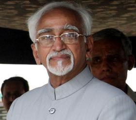
Mohammad Hamid Ansari
মহম্মদ হামিদ আনসারি
محمد حامد انصاری
Hamid ansari.jpg
14th Vice President of India
Incumbent
Assumed office
11 August 2007
PresidentPratibha Patil
Pranab Mukherjee
Preceded byBhairon Singh Shekhawat
Personal details
Born(1937-04-01) 1 April 1937 (age 76)
Calcutta, Bengal Presidency, British India
(now Kolkata, West Bengal, India)
Spouse(s)Salma Ansari
Alma materUniversity of Calcutta
Aligarh Muslim University
Religion: slam

Mohammad Hamid Ansari (About this sound pronunciation ;Bengali: মহম্মদ হামিদ আনসারি;Urdu: محمد حامد انصاری‎)( born 1 April 1937) is the 14th and current Vice President of India, in office since 2007. After Dr. Sarvepalli Radhakrishnan, Hamid Ansari is the only person to get elected for the post of Vice President of India at two consecutive terms. He also presently serves as President of the Indian Institute of Public Administration and Chancellor of Panjab University, Chandigarh.
Ansari worked as an ambassador and served as Vice-Chancellor of the Aligarh Muslim University from 2000 to 2002.[1] Later he was Chairman of the National Commission for Minorities[1] from 2006 to 2007. He was elected as Vice President of India on 10 August 2007 and took office on 11 August 2007. He was re-elected on 7 August 2012 and was sworn-in by Pranab Mukherjee, the President of India. The oath taking ceremony was conducted at Rashtrapati Bhavan on August 11, 2012.[2]
Wikipedia.
Vicepresidente de la India llega el sábado a Perú para visita oficial
Mapa

Vicepresidente de la India llega el sábado a Perú para visita oficial
(EFE) – Hace 1 día 
Lima, 25 oct (EFE).- El vicepresidente de la India, Mohammad Hamid Ansari, llegará mañana, sábado, a Perú en una visita oficial para estrechar los lazos políticos, económicos y de cooperación entre ambos países, según informó hoy la cancillería peruana en un comunicado.
En el marco de su visita, el vicepresidente indio hará un "saludo de cortesía" al presidente peruano, Ollanta Humala, y será recibido el lunes por el Presidente del Congreso, Fredy Otárola, y por los miembros de la Liga Parlamentaria de Amistad Perú - India, en la sede del Legislativo.
También será recibido el lunes por su homóloga peruana, Marisol Espinoza, y por la ministra de Relaciones Exteriores, Eda Rivas Franchini, cuando se conmemora el 50 aniversario del establecimiento de relaciones diplomáticas entre ambos países.
A continuación, las delegaciones de ambos países sostendrán una reunión de trabajo, suscribirán acuerdos de cooperación en materia de educación, cultura y defensa, y emitirán una Declaración Conjunta.
Según el comunicado, está previsto que en el marco de esta visita se "anuncie el inicio de negociaciones para la firma de un Tratado de Libre Comercio", ya que un uno de los objetivos prioritarios en las relaciones bilaterales entre Perú y la India es el incremento de las inversiones y el fomento del intercambio comercial.
En los últimos cuatro años el comercio entre ambos países creció de manera constante, superando los 1.000 millones de dólares en el 2012.


Perú e India reforzarán relación económica
          
El vicepresidente de la India,
Perú e India reforzarán relación económica
El vicepresidente de la India, Mohammad Hamid Ansari, arribó a Lima para cumplir una visita oficial. Lo hizo acompañado por una numerosa delegación que se reunirá con autoridades del Gobierno peruano, informó el Ministerio de Relaciones Exteriores.
El propósito de la visita del vicepresidente indio es estrechar los lazos que unen a nuestros países en los ámbitos político, económico y de cooperación, en el contexto de conmemorarse el 50º aniversario del establecimiento de relaciones diplomáticas entre las dos naciones.

Mañana, Mohammad Hamid Ansari será recibido en la sede del Congreso por el titular de este poder del Estado, Fredy Otárola, y por los integrantes de la Liga Parlamentaria de Amistad Perú-India. El funcionario acudirá posteriormente a la sede de la Cancillería para entrevistarse con la vicepresidenta Marisol Espinoza y la ministra Eda Rivas. También recibirá el saludo del Jefe del Estado.

arribó a Lima para cumplir una visita oficial. Lo hizo acompañado por una numerosa delegación que se reunirá con autoridades del Gobierno peruano, informó el Ministerio de Relaciones Exteriores.
 
El propósito de la visita del vicepresidente indio es estrechar los lazos que unen a nuestros países en los ámbitos político, económico y de cooperación, en el contexto de conmemorarse el 50º aniversario del establecimiento de relaciones diplomáticas entre las dos naciones.
 
Mañana, Mohammad Hamid Ansari será recibido en la sede del Congreso por el titular de este poder del Estado, Fredy Otárola, y por los integrantes de la Liga Parlamentaria de Amistad Perú-India. El funcionario acudirá posteriormente a la sede de la Cancillería para entrevistarse con la vicepresidenta Marisol Espinoza y la ministra Eda Rivas. También recibirá el saludo del Jefe del Estado.
Guillermo Gonzalo Sánchez Achutegui
ayabaca@yahoo.com Inscríbete en el Foro del blog y participa : A Vuelo De Un Quinde - El Foro!

RELIGIÓN BUDISTA: Miles de personas despiden al patriarca supremo de los budistas de Tailandia


Somdet Phra Nyanasamvara (Associated Press)
Somdet Phra Ñāṇasaṃvara
Somdet Phra Saṅgharāja
Sakalamahāsaṅghapariṇāyaka
(Charoen Suvaḍḍhano)
ReligionBuddhism
SchoolTheravada, Dhammayuttika Nikaya
Other name(s)Somdet Phra Nyanasamvara
Somdet Phra Yannasangwon
Dharma name(s)Suvaḍḍhano
Personal
NationalityThai
Born(1913-10-03)3 October 1913
Kanchanaburi Province, Thailand
Died24 October 2013(2013-10-24) (aged 100)
Bangkok, Thailand
Senior posting
TitleSupreme Patriarch of Thailand
PredecessorSomdet Phra Sangharaja (Vasana Vasano
Wikipedia.


Miles de personas despiden al patriarca supremo de los budistas de Tailandia
Mapa

Miles de personas despiden al patriarca supremo de los budistas de Tailandia
(EFE) – hace 13 horas 
Bangkok, 27 oct (EFE).- Miles de personas han dedicado hoy la jornada dominical a presentar sus respetos al patriarca supremo de los budistas de Tailandia, Somdet Phra Nyanasamvara, quien falleció esta semana a los cien años de edad tras una larga enfermedad.
Los tailandeses, la mayoría vestidos de negros, abarrotaron hoy el templo Vihara Bowonnives, el mayor monasterio budista de la tradición Dhammayu del noreste de Bangkok, según los medios locales.
La espera es larga porque sólo pueden entrar 20 personas a la vez, desde las ocho de la mañana y hasta las nueve de la noche, en la cámara donde yace el décimo noveno patriarca supremo de Rattanakosin.
Los discípulos y devotos pueden da su último adiós a Nyanasamvara en Vihara Bowonnives hasta el próximo miércoles.
El rey Bhumibol Adulyadej de Tailandia, quien pasó una temporada como monje bajo la guía espiritual de este patriarca supremo, ha decretado 30 días de luto en el Palacio Real y encomendó que los restos descansaran en el templo Bowon Niwet de la capital.
Los ritos funerario reales concluirán el 31 de enero de 2014 y partir de entonces el Consejo Supremo Sangha empezará el proceso para nominar siete candidatos, de los cuales el rey elegirá el sucesor, de acuerdo con la Oficina Nacional del Budismo.
Nyanasamvara nació el 3 de octubre de 1913 en la provincia de Kanchanaburi, en el oeste de Tailandia, y le llamaron Charoen Gajavatra.
Pronto se quedó huérfano de padre, por lo que su madre se hizo cargo de él y sus dos hermanos.
A los 14 años ingresó de novicio en un monasterio, en cumplimiento de la promesa que había hecho su madre durante una enfermedad que padeció, y al año siguiente lo traspasaron a Bowon Niwet, donde el rey tailandés cree que deben reposar sus restos
Cuando cumplió la mayoría de edad, en 1933, fue ordenado monje y asumió el nombre de Suwatano, uno más de los que obtendría a lo largo de su vida para acabar siendo llamado Somdet Phra Nyanasamvara.
Durante su vida recibió varios títulos honoríficos, escribió numerosos libros y fue reconocido por su labor en la construcción de escuelas y templos en las zonas rurales.
En 1999, por problemas de salud, abandonó sus obligaciones en el Consejo de la Sangha, el organismo que supervisa las órdenes budistas en el país, y falleció el pasado jueves por una infección sanguínea en el hospital de Chulalongkorn en Bangkok, donde recibía tratamiento médico desde 2002.
EFE
 
Followers flock to temple to pay their last respects to His Holiness
BANGKOK - A throng of loving disciples and people adorned in black attended Bangkok's Wat Bowonnives Vihara Temple yesterday, the first day that members of the public could pay their respects to His Holiness Somdet Phra Nyanasamvara, the 19th Supreme Patriarch of Rattanakosin, who died on Thursday aged 100.
From 8am to 9pm, the temple allowed 20 visitors per session to pay their respects and view His Holiness's body. Members of the public can also attend Abhidhamma chanting ceremonies, which will take place daily until this Wednesday.
A 4-D exhibition marking major historical events over the past 100 years is also open to the public to commemorate His Holiness' life.
The Office of the Supreme Patriarch's Secretary will ensure that charity projects initiated by His Holiness - including a project to raise donations for flood victims in hard-hit Prachin Buri's Bang Sang district - will continue, despite his passing.
Meanwhile, Office of National Buddhism director-general Nopparat Benjawatananun said the Sangha Supreme Council of Thailand, would choose possible successors to His Holiness at their meeting on Wednesday. It would then present its selection to the prime minister for announcement in the "Royal Gazette", he explained.
In related news, the Bangkok Metropolitan Administration (BMA) will host an alms-offering ritual on October 31 to mark the seventh day of His Holiness's passing, said BMA Permanent Secretary Ninnat Chalitanon yesterday. As is their policy, BMA offices will fly the national flag at half-mast until today in mourning for His Holiness. Officials will also wear black for 30 days until November 23, and district offices will provide an area for members of the public to sign their condolences, Ninnat added.
Born on October 3, 1913 in Kanchanaburi province, His Holiness was the longest-living Supreme Patriarch in Thai history. On October 14, he underwent intestinal surgery at Chulalongkorn Hospital and passed away peacefully at 7.30pm on October 24.
Thais News.
Guillermo Gonzalo Sánchez Achutegui