http://www.esa.int/Our_Activities/Observing_the_Earth/Copernicus/Sentinel-1/Sentinel_satellites_reveal_east_west_shift_in_Italian_quake

Details
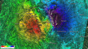
- Title Mapping Italy’s 30 October 2016 earthquake
- Released 02/11/2016 12:00 pm
- Copyright Contains modified Copernicus Sentinel data (2016)/ESA/CNR-IREA
- DescriptionIn the early hours of 30 October 2016, a 6.5 magnitude earthquake struck central Italy. Scientists from Italy’s Institute for Electromagnetic Sensing of the Environment combined a Copernicus Sentinel-1B radar image from 26 October with a Sentinel-1A radar image from 1 November to analyse ground displacements caused by the quake.The results show ground deformations extending across about 130 sq km with a maximum displacement of about 70 cm (in the direction of the satellite), in the area of Castelluccio.The work was carried out under the coordination of the Italian Department of Civil Protection, and in collaboration with Italy’s National Institute for Geophysics and Volcanology.
- Id 367957
TAGS
- Click on the tags to find the matching images.
- Activity Observing the Earth
- Mission Sentinel-1
- System Copernicus
- Location Italy
- Keywords Earthquakes , InSAR , Radar , Radar Images , Radar data , Synthetic Aperture Radar
Sentinel satellites reveal east–west shift in Italian quake
East–west shift
3 November 2016
New information on the effects of the 30 October earthquake that struck central Italy continues to emerge as scientists analyse radar scans from satellites.
Using radar imagery from the Copernicus Sentinel-1 satellites, Italian experts have identified significant east–west displacements of the ground in the area struck by the earthquake.
An eastwards shift of about 40 cm was mapped in the vicinity of Montegallo, while a westwards shift of about 30 cm is centred in the area of Norcia.
Vertical displacement is also evident, with the ground sinking 60 cm around Castelluccio but rising by about 12 cm around Norcia.
The team of scientists from the Institute for Electromagnetic Sensing of the Environment of the National Research Council and the National Institute of Geophysics and Volcanology combined radar scans taken before and after the event to map centimetre-scale changes.
The team has benefited from the two Sentinel-1 satellites of Europe’s Copernicus programme. While Copernicus is led by the European Commission, ESA is in charge of developing the satellites and operates Sentinel-1.

Vertical displacement
“These impressive scientific results could be obtained very rapidly thanks to the operations concept of the Sentinel-1 mission: large scale and frequent mapping, in particular of Europe and worldwide tectonic areas, tight satellite orbit control, systematic processing of all acquired data, and open and free access of the products within few hours from observation,” said Pierre Potin, Sentinel-1 mission manager at ESA.
“In this specific case, the east–west and vertical ground displacements could be derived in less than three days after the earthquake, making use of both Sentinel-1A and Sentinel-1B and in different viewing geometries.”
Sentinel-1 is not the only satellite providing information on this recent quake: scientists are also relying on the Italian space agency’s Cosmo-SkyMed satellites, as well as satellite images from other space agencies.
The Italian peninsula is prone to earthquakes because of the continuing collision of the African and Eurasian tectonic plates. Under the Apennine mountain chain, the regional collision is causing the African slab to flex and dip under the Tyrrhenian Sea, while at the same time retreating northeastwards.
Guillermo Gonzalo Sánchez Achutegui
ayabaca@gmail.com
ayabaca@hotmail.com
ayabaca@yahoo.com
Inscríbete en el Foro del blog y participa : A Vuelo De Un Quinde - El Foro!

No hay comentarios:
Publicar un comentario