Mostrando entradas con la etiqueta The Copernicus Sentinel-1. Mostrar todas las entradas

domingo, 2 de abril de 2017

ESA : Satellites shed new light on earthquakes .- Los satélites arrojan nueva luz sobre los terremotos.....

http://www.esa.int/Our_Activities/Observing_the_Earth/Copernicus/Sentinel-1/Satellites_shed_new_light_on_earthquakes

Kaikoura quake
 
24 March 2017
Satellite radar scans of last year’s earthquake in New Zealand are changing the way we are thinking about earthquake hazards in regions where our planet’s tectonic plates meet.
The 7.8-magnitude quake that struck New Zealand’s South Island near the town of Kaikoura on 14 November was one of the most comprehensively recorded earthquakes in history.
Immediately after it, a team of scientists from New Zealand, the UK and the US began to study radar images from the Copernicus Sentinel-1 and Japanese ALOS-2 missions to measure the extent of the land movement.
They found that the quake caused the ground to rise by 8–10 m and offset features like roads that crossed the fault by up to 12 m. This caused large landslides and triggered a tsunami.
Satellite radar scans from before and after the quake showed that the ground-based seismic readings were not giving accurate assessments of where the ruptures were occurring.
Seismic readings are based on the shockwaves rippling through Earth. Although they are the quickest way to gather information on earthquakes, they are unable to show details in complex quakes like Kaikoura.
 
3D ground displacement using Sentinel-1 data
 
But radar satellites like Sentinel-1 can detect movements of millimetres in the ground and across wide areas, providing a detailed picture of land deformation and the locations of fault lines.
In the case of Kaikoura, it showed the research team that ruptures took place across many separate faults.
They saw that the complexity and large amount of uplift point towards how mountains in regions such as New Zealand could build rapidly.
“We’ve never seen anything like the Kaikoura quake before – it was one of the most complex ever recorded,” said Professor Tim Wright, study co-author and director of the Centre for the Observation and Modelling of Earthquakes, Volcanoes and Tectonics at the UK’s University of Leeds.
“An earthquake commonly ruptures across a single fault line or faults that are closely grouped, but Kaikoura ruptured at least 12 major crustal faults across two distinct active fault domains.
“This challenges many assumptions about how individual faults control earthquake ruptures.”
The study published yesterday in Science has prompted scientists to reassess how many different faults can be involved in a single earthquake, and could potentially help to re-evaluate seismic hazard models.


Sentinel-1
 
“There was growing evidence internationally that conventional seismic hazard models are too simple and restrictive,” said Dr Ian Hamling, a natural hazards geodesist from New Zealand research institute GNS Science and the lead author of the study.
“The message from Kaikoura is that earthquake science should be more open to a wider range of possibilities when rupture models are being developed. It underlines the importance of re-evaluating how rupture scenarios are defined for seismic hazard models. ”
New Zealand’s complex network of faults is similar to those found in western US, Japan and central Asia.
“While earthquakes like Kaikoura’s do not commonly occur, the data we’ve gathered from this event will expand our understanding of similar boundary zones around the world,” said Dr John Elliott from Leeds’ School of Earth and Environment, and co-author.
“Not only could the data help inform us for the future but it may change how we’ve interpreted ancient earthquakes.
“If an earthquake like Kaikoura’s took place thousands of years ago, current methods of paleoseismology would possibly see it as a series of earthquakes over a long period of time, rather than as one large single quake.”
Inscríbete en el Foro del blog y participa : A Vuelo De Un Quinde - El Foro!

domingo, 19 de febrero de 2017

ESA : Sentinels warn of dangerous ice crack .- Los centinelas advierten sobre una peligrosa grieta de hielo....

http://www.esa.int/Our_Activities/Observing_the_Earth/Sentinels_warn_of_dangerous_ice_crack
                                                                                                                                          
Halloween Crack

Sentinels warn of dangerous ice crack

16 February 2017
Following the appearance of a large crack in the ice shelf close to the Halley VI research station in Antarctica, information from the Copernicus Sentinel-1 and Sentinel-2 satellites helped to decide to close the base temporarily.
Nourished by an inflow of ice from grounded glaciers and snow accumulating on its surface, Brunt Ice Shelf is a floating ice sheet in the Weddell Sea Sector of Antarctica. The floating ice moves steadily towards the ocean, where it occasionally calves off as icebergs.
Cracks often appear on shelves as the ice deforms. However, rapidly expanding cracks indicate impending calving.
Since the Halley VI base of the British Antarctic Survey was only 17 km from the crack that appeared last October, Enveo – a company that uses satellite data for cryosphere studies – and the Survey used radar images from Sentinel-1 and optical images from Sentinel-2 to monitor the situation.
 
Relocating Halley station

Dubbed Halloween Crack, it was lengthening inland as fast as 600 m a day in November and December.
Halley was designed to be relocated if the ice becomes dangerous. In fact, it had already been moved 23 km inland during last Antarctica’s summer months because another ice chasm had begun to show signs of growth.
Recent Sentinels sequences revealed a complex picture that made it difficult to predict how the Halloween Crack would evolve, so the Survey decided to evacuate and shut the base for the coming winter as a precaution.
Normally, around 70 people live and work at the base during the summer and fewer than 20 during the winter. However, this is the first winter that the base has been completely closed.
Thomas Nagler, Enveo CEO, said, “We get Sentinel-1 and Sentinel-2 data shortly after acquisition so we are able extract information on the crack’s progression and deliver this information to our Survey colleagues very quickly.”
 
Shelf deformation

Hilmar Gudmundsson, Survey lead scientist, added, “The frequency of Sentinel-2 images and Sentinel-1 radar products allows us to follow in detail and almost in real time the development of the crack as it grows week by week.
“This also provides us with essential information for ice-deformation models, leading to a deeper understanding of such events.”
The two Sentinel missions are being used to closely monitor three main aspects: Halloween Crack, which is now growing at about 200 m a day, two other ice chasms and detect new cracks.
Since November, Sentinel-2 has been programmed to acquire images at each overflight to maximise the chances of getting cloud-free images.
Sentinel-1A and Sentinel-1B have also been continually gathering data with two crossing tracks. This allows the rifts to be mapped showing how the ice shelf deforms at the tip of the growing crack.
 
Sentinel-1 monitoring motion
 
Mark Drinkwater, head of ESA’s Earth observation mission, added “Routine Antarctic summer observations by the combination of Copernicus Sentinel-2A and Sentinel-1A and -1B are now demonstrating their value for monitoring rapid environmental change and providing information crucial to informed decisions on matters of safety and security in Antarctica.
“Though without direct effect on Antarctic infrastructure, similarly dramatic summer development of ice-shelf fractures is revealed around Antarctica, notably Pine Island glacier in West Antarctica and the Larsen-C ice shelf in the Weddell Sea region.”
Antarctica will soon be facing the dark winter months. Importantly, Sentinel-1’s radar will continue to provide images so that these changes can be monitored.

Related articles

Satellites track variations in Antarctica’s glacial retreat
12 December 2016
                Five satellites spanning two decades have revealed variations in the timing and pace of glacial retreat in West Antarctica. Some glaciers’ thinning spreads up to three times faster than on neighbouring tributaries, and was offset by decades.
ESA
Guillermo Gonzalo Sánchez Achutegui

domingo, 30 de octubre de 2016

ESA : Keep an automatic eye on seismic zones .- Mantengqa un ojo automático en las zonas sismicas

http://www.esa.int/Our_Activities/Observing_the_Earth/Copernicus/Sentinel-1/Keep_an_automatic_eye_on_seismic_zones

Keep an automatic eye on seismic zones

European seismic zones
 
28 October 2016
The Copernicus Sentinel-1 twin radar satellites combined with cloud computing are monitoring Europe’s earthquake zones by searching for ground shifts as small as a millimetre. 
Radar was developed in the last century to pick up aircraft moving at hundreds of kilometres per hour. Today’s satellite radar can reveal otherwise invisible shifts in the ground taking place as slowly as the growth of your fingernails.
The new, automatic radar service covers Europe’s seismic regions, monitoring an area of three million square kilometres in 200 m blocks.
Once any motion of interest has been identified, more detailed checks can be made through ESA’s Geohazards Exploitation Platform.
“The quick-browse service has been under way across European tectonic regions since January, harnessing automated processing developed by the DLR German Aerospace Center,” explains Fabrizio Pacini of Terradue, overseeing the Platform. 
 
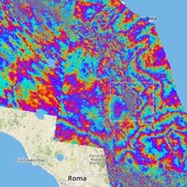
Earthquake area in Italy

“Our plan next year is to gradually scale up to cover the entire world’s tectonic regions, which adds up to a quarter of Earth’s land surface.
“Such wide-area coverage is really unprecedented. It is a crucial step towards empowering society at large to reduce the risk from earthquakes and volcanoes.”
The satellites take successive radar images of the same location which are then combined to reveal the slightest shift.
Today, it is a well-established technique used to give authoritative snapshots of ground movements following events such as the recent earthquakes in central Italy.
Earth scientists were surprised in the 1980s when centimetre-accuracy GPS networks revealed previously unsuspected motion along tectonic plates, occurring between larger-scale seismic events. 
 
Ground displacement from Italy’s earthquake

Combined radar scans are sensitive down to a level of millimetres and over wide areas, compared to point-by-point GPS measurements, but the process demands heavy computing power.
“The real step change here is that they are being produced across extended areas on an entirely automated basis,” adds Fabrizio.
The service is processing an average 50 image pairs per day across Europe from the Sentinel-1A and Sentinel-1B satellites, with six days between coverage.
Next year, this will increase to 130 pairs per day, with a maximum of 24 days and potentially 12 days between acquisitions outside Europe, involving the daily processing of 1 terabyte of data, with additional higher resolution produced on request.
Processing on such a grand scale is enabled by the online, cloud-based Geohazards Exploitation Platform, specifically tailored for working with vast amounts of satellite data.
 
Geohazards TEP
 

Related articles

29 August 2016
 On 24 August, an earthquake struck central Italy, claiming at least 290 lives and causing widespread damage. Satellite images are being used to help emergency aid organisations, while scientists have begun to analyse ground movement.
12 May 2016
While the growing volume information from satellites observing Earth offers a unique opportunity for science and applications, it is sometimes difficult to make sure these complex data streams are exploited to their full potential. ESA is addressing t... 
ESA
Guillermo Gonzalo Sánchez Achutegui
ayabaca@gmail.com
ayabaca@hotmail.com
ayabaca@yahoo.com
Inscríbete en el Foro del blog y participa : A Vuelo De Un Quinde - El Foro!

Mi lista de blogs