Mostrando entradas con la etiqueta the Gulf of Alaska. Mostrar todas las entradas

domingo, 5 de marzo de 2017

The National Science Foundation (NSF) : NSF announces new Long-Term Ecological Research sites off Alaska, New England coasts .- NSF anuncia nuevos sitios de Investigación Ecológica a Largo Plazo frente a Alaska, y en las costas de Nueva Inglaterra

https://www.nsf.gov/news/news_summ.jsp?cntn_id=191149&WT.mc_id=USNSF_51&WT.mc_ev=click

Scientists will expand research on ocean food webs in ecosystems that include recreational and commercial fisheries
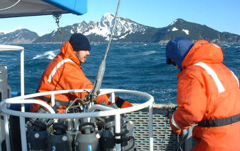
Scientists at the Northern Gulf of Alaska LTER site conduct research off the coast of Alaska.

Scientists at the Northern Gulf of Alaska LTER site conduct research off the coast of Alaska.
Credit and Larger Version

March 1, 2017
National Science Foundation (NSF) grants will support two new Long-Term Ecological Research (LTER) sites. Scientists will conduct research along the Northeast U.S. continental shelf and in the northern Gulf of Alaska, regions known for productive fisheries and abundant marine resources.
The new LTER sites were each awarded $5.6 million over five years, adding to 25 existing LTER sites in ecosystems including the open ocean, coral reefs, deserts and grasslands. The complex food webs in these regions are affected by human activities, short-term environmental variability and long-term ecosystem changes.
"The new LTER sites will bring new locations, technologies and scientists to the challenge of understanding our coastal oceans," says Rick Murray, director of NSF's Division of Ocean Sciences. "The sites are in areas where there's much recreational and commercial fishing, and both sites are in the midst of significant environmental changes."
Murray adds that "research at the new sites will matter to everyone who eats U.S. seafood, is involved in coastal industries, or depends on the coastal oceans in any way. That includes all of us, through the oceans' importance in weather and climate and a long list of other 'ecosystem services' the sea provides."
Researchers at the Woods Hole Oceanographic Institution (WHOI), along with scientists at the University of Massachusetts, Wellesley College and the University of Rhode Island, will lead the Northeast U.S. Shelf LTER site.
Scientists at the University of Alaska Fairbanks, in collaboration with researchers at Western Washington University, Oregon State University and the University of California, Santa Cruz, will manage the Northern Gulf of Alaska LTER site.

Northeast U.S. Shelf LTER site

Scientists have documented environmental changes in the Atlantic Ocean off the U.S. Northeast coast, but they've lacked an understanding of the links among the ocean environment, plankton food webs and fish stocks. That has limited their ability to predict how this ecosystem will respond to environmental change. Research at the new LTER site will fill that gap.
The NSF Northeast U.S. Shelf LTER site spans the continental shelf across an area connecting the WHOI-operated Martha's Vineyard Coastal Observatory with the Pioneer Array, part of NSF's Ocean Observatories Initiative. The Pioneer Array, a group of moorings and other instruments, is located off the coast of southern New England where coastal waters meet the open ocean.
These instruments collect continuous data and, along with samples retrieved by scientists aboard ships, will become integral parts of ecological models of the changing Atlantic ecosystem.
"This is an exciting opportunity to develop a much more detailed understanding of the ocean," says WHOI biologist Heidi Sosik, principal investigator of the project. "We want to know how different pathways in the food web may shift seasonally or with environmental change. Ultimately, we hope this knowledge can help promote science-based stewardship of marine ecosystems and be applied to the ocean beyond the waters of the Northeast."

Northern Gulf of Alaska LTER site

Two decades of research along Alaska's Seward Line -- a series of ocean sampling stations extending from Resurrection Bay near Seward, Alaska to the continental slope 150 miles offshore -- are the foundation of the new NSF Northern Gulf of Alaska LTER site.
"We've monitored Prince William Sound and the continental shelf long enough to know where many of the important features are," says Russ Hopcroft, a scientist at the University of Alaska Fairbanks and the principal investigator of the new LTER site. "But until now, we haven't been able to study the processes and mechanisms in-depth behind what we've been observing."
The new LTER site will allow researchers to make observations across a larger geographic region. It will also give scientists an opportunity to undertake studies aboard the NSF research vessel Sikuliaq, operated by the University of Alaska Fairbanks.
Researchers at the Northern Gulf of Alaska LTER site will study the gulf's waters, which support the well-known fish, crabs, seabirds and marine mammals of Alaska.
The scientists say that the addition of the Northern Gulf of Alaska site to the LTER network will lead to a better understanding of an ecosystem with many of the nation's largest fisheries.
-NSF-
Media Contacts Cheryl Dybas, NSF, (703) 292-7734,
 cdybas@nsf.gov
Stephanie Murphy, WHOI - Northeast U.S. Shelf LTER Site, (508) 289-3340,
 samurphy@whoi.edu
Lauren Frisch, University of Alaska Fairbanks - Northern Gulf of Alaska LTER Site, (907) 474-5350, lcfrisch@alaska.edu
Related WebsitesNSF LTER Network:
 https://lternet.edu/
NSF LTER Discovery Article Series:
https://www.nsf.gov/news/newsmedia/ENV-discoveries/LTREB-discovery-series.jsp

The National Science Foundation (NSF) is an independent federal agency that supports fundamental research and education across all fields of science and engineering. In fiscal year (FY) 2016, its budget is $7.5 billion. NSF funds reach all 50 states through grants to nearly 2,000 colleges, universities and other institutions. Each year, NSF receives more than 48,000 competitive proposals for funding and makes about 12,000 new funding awards. NSF also awards about $626 million in professional and service contracts yearly.
 Get News Updates by Email 

Useful NSF Web Sites:
NSF Home Page:
 https://www.nsf.gov
NSF News:
https://www.nsf.gov/news/
For the News Media:
https://www.nsf.gov/news/newsroom.jsp
Science and Engineering Statistics:
https://www.nsf.gov/statistics/
Awards Searches:
https://www.nsf.gov/awardsearch/

                                    Researchers at the Northeast U.S. Shelf LTER site deploy instruments off the coast of Massachusetts.
Credit and Larger Version
Alewives, a species of river herring, make their way from the Atlantic Ocean to a pond on land.
Credit and Larger Version
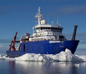
Researchers at the Northern Gulf of Alaska LTER site will study the gulf from aboard the Sikuliaq.
Credit and Larger Version
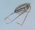
A subarctic copepod species is one of the keystone zooplankton species in the Gulf of Alaska.
Credit and Larger Version
View of a diatom chain through an automated submersible microscope operating off Massachusetts.
Credit and Larger Version
The National Science Foundation (NSF)
  Researchers at the Northeast U.S. Shelf LTER site deploy instruments off the coast of Massachusetts.
Researchers at the Northeast U.S. Shelf LTER site deploy instruments off the coast of Massachusetts.
Credit and Larger Version
Alewives, a species of river herring, make their way from the Atlantic Ocean to a pond on land.
Credit and Larger Version
Researchers at the Northern Gulf of Alaska LTER site will study the gulf from aboard the Sikuliaq.
Credit and Larger Version
A subarctic copepod species is one of the keystone zooplankton species in the Gulf of Alaska.
Credit and Larger Version
View of a diatom chain through an automated submersible microscope operating off Massachusetts.
Credit and Larger Version
Guillermo Gonzalo Sánchez Achutegui
ayabaca@gmail.com
ayabaca@hotmail.com
ayabaca@yahoo.com
Inscríbete en el Foro del blog y participa : A Vuelo De Un Quinde - El Foro!

sábado, 28 de noviembre de 2015

NSF: Climate can grind down mountains faster than they can rebuild .- El clima puede moler abajo de las montañas más rápido de lo que pueden reconstruir

Hola amigos: A VUELO DE UN QUINDE EL BLOG., Por primera vez, los investigadores han tratado de medir todo el material que entran y salen de una cadena montañosa a lo largo de más de un millón de años.
Han descubierto que la erosión causada por la glaciación durante las edades de hielo puede, en las circunstancias adecuadas, desgastar a las montañas más rápido que la tectónica de placas pueden construirlos.
El estudio, realizado por Integrated Océano Drilling Program (IODP) investigadores y liderado por científicos de la Universidad de Texas en Austin, la Universidad de Florida y la Universidad Estatal de Oregon, añade una idea de un debate de larga data sobre el equilibrio del clima y de las fuerzas tectónicas que la influencia formación de montañas.
More information............

Erosion caused by glaciation can wear down mountains faster than plate tectonics can form them

The coast of Alaska and the Bering Glacier viewed from the ocean drillship JOIDES Resolution.
Credit and Larger Version
November 23, 2015
For the first time, researchers have attempted to measure all the material leaving and entering a mountain range over the course of more than a million years.
They've discovered that erosion caused by glaciation during ice ages can, in the right circumstances, wear down mountains faster than plate tectonics can build them.
The study, conducted by Integrated Ocean Drilling Program (IODP) researchers and led by scientists from the University of Texas at Austin, the University of Florida and Oregon State University, adds insight into a longstanding debate over the balance of climate and tectonic forces that influence mountain building.
The findings are published today in a paper in the journal Proceedings of the National Academy of Sciences. The study was funded by the National Science Foundation (NSF) and IODP.
The geoscientists studied the St. Elias Mountains on the Alaska coast. They found erosion accelerated sharply about one million years ago when global climate cooling triggered stronger and more persistent ice ages than in times past.
Used seismic equipment, the researchers imaged and mapped a huge fan of sediment deep in the Gulf of Alaska, caused by the erosion of nearby mountains. They then took sediment cores to understand the system.
 
Earth's systems interconnected
 
"This study demonstrates how interconnected Earth's systems are, showing that glaciers, tectonics and erosion cannot be considered as independent processes," said Rick Murray, director of NSF's Division of Ocean Sciences. "The results clearly show that extracting sediment cores from a series of single locations allows for insight into global-scale processes."
In IODP Expedition 341, a three-month voyage in 2013, the scientists collected and dated almost 2.5 miles of sediment from the floor of the Gulf of Alaska and the Alaskan continental shelf, revealing millions of years' worth of geological history.
"It turned out that most sediments were younger than we anticipated and most rates of sediment production and thus erosion were higher than we anticipated," said lead paper author Sean Gulick of the University of Texas at Austin's Institute for Geophysics.
Between 1.25 million and 700,000 thousand years ago, Earth experienced a climate change known as the mid-Pleistocene transition, when the planet's cycle changed from short ice ages of about 40,000 years to super-long ice ages of about 100,000 years. Since that transition, Gulick said, "Erosion became much greater. In fact, there was more erosion than tectonics has replaced."
"The composition of the sediment gave clear evidence of when the glaciation started, then expanded, in sync with global climate trends over the past several million years," said paper co-author Alan Mix of Oregon State University. "Only by drilling the sea floor where the sediment accumulates could we see these details."
 
Climate vs. tectonic processes
 
Mountain ranges form when tectonic plates thrust into one another over millions of years and crunch the Earth's outer crust. But even as mountains are built by these forces, other agents--a combination of tectonic and climate processes--work to remove the accumulating crust.
Since the mid-Pleistocene, erosion rates have continued to exceed tectonic inputs by 50 to 80 percent, demonstrating that climate processes, such as the movement of glaciers, can outstrip mountain building over the span of a million years.
The findings highlight the pivotal role climate fluctuations play in shaping Earth's landforms.
"Humans often see mountain ranges as static, unyielding parts of the landscape," said geoscientist John Jaeger of the University of Florida, a co-author of the paper. "But they are actively evolving along with and responding to Earth's climate, which demonstrates how dynamic and coupled this planet is."
-NSF-
Media Contacts Cheryl Dybas, NSF, (703) 292-7734,
cdybas@nsf.gov
Anton Caputo, University of Texas, (512) 232-9623,
 anton.caputo@jsg.utexas.edu

Related WebsitesNSF Grant: Collaborative Research: Linking climate-driven changes in erosion to tectonic processes along the southern Alaska Margin:
http://www.nsf.gov/awardsearch/showAward?AWD_ID=1435121&HistoricalAwards=false
IODP Expedition 341:
http://1.usa.gov/1TahW5n


The National Science Foundation (NSF) is an independent federal agency that supports fundamental research and education across all fields of science and engineering. In fiscal year (FY) 2015, its budget is $7.3 billion. NSF funds reach all 50 states through grants to nearly 2,000 colleges, universities and other institutions. Each year, NSF receives about 48,000 competitive proposals for funding, and makes about 11,000 new funding awards. NSF also awards about $626 million in professional and service contracts yearly.
 Get News Updates by Email 
Useful NSF Web Sites:
NSF Home Page:
 http://www.nsf.gov
NSF News:
http://www.nsf.gov/news/
For the News Media:
 http://www.nsf.gov/news/newsroom.jsp
Science and Engineering Statistics:
http://www.nsf.gov/statistics/
Awards Searches:
http://www.nsf.gov/awardsearch/
The scientific drilling vessel JOIDES Resolution
The scientific drilling vessel JOIDES Resolution and its crew work in the Gulf of Alaska.
Credit and Larger Version
A glacier in Icy Bay, Alaska
A glacier in Icy Bay, Alaska, erodes geologically young rocks like those found in sea floor samples.
Credit and Larger Version
Twop scientists in a lab working on sediment cores
Scientists conduct research on sediment cores collected from beneath the Gulf of Alaska sea floor.
Credit and Larger Version
Five sediment cores
Cores must equilibrate to lower pressures at the surface; sometimes cracks form in the process.
Credit and Larger Version
St. Elias Mountains along the Alaska coast.
Geoscientists from several institutions studied the St. Elias Mountains along the Alaska coast.
Credit and Larger Version
The National Science Foundation (NSF)
Guillermo Gonzalo Sánchez Achutegui
ayabaca@gmail.com
ayabaca@hotmail.com
ayabaca@yahoo.com
Inscríbete en el Foro del blog y participa : A Vuelo De Un Quinde - El Foro!

viernes, 22 de agosto de 2014

NASA : Retreat of Yakutat Glacier


Retreat of Yakutat Glacier
Located in the Brabazon Range of southeastern Alaska, Yakutat Glacier is one of the fastest retreating glaciers in the world. It is the primary outlet for the 810-square kilometer (310-square mile) Yakutat ice field, which drains into Harlequin Lake and, ultimately, the Gulf of Alaska.
The Operational Land Imager on the Landsat 8 satellite captured this image of the glacier and lake on Aug. 13, 2013. Snow and ice appear white and forests are green. The brown streaks on the glaciers are lateral and medial moraines.
Over the past 26 years, the glacier’s terminus has retreated more than 5 kilometers (3 miles). What is causing the rapid retreat? University of Alaska glaciologist Martin Truffer and colleagues pointed to a number of factors in their 2013 study published in the Journal of Glaciology. The chief cause is the long-term contraction of the Yakutat Ice Field, which has been shrinking since the height of the Little Ice Age.
Once part of a much larger ice field, Yakutat has been contracting for hundreds of years. As other nearby glaciers retreated, Yakutat ice field was cut off from higher-elevation areas that once supplied a steady flow of ice from the north. With that flow cut off, there simply is not enough snow falling over the low-elevation Yakutat ice field to prevent it from retreating.
Beyond this natural change, human-caused global warming has hastened the speed of the retreat. Between 1948–2000, mean annual temperatures in Yakutat increased by 1.38° Celsius (2.48° Fahrenheit). Between 2000 and 2010, they rose by another 0.48°C (0.86°F). The warmer temperatures encourage melting and sublimation at all ice surfaces exposed to the air.
In the past few years, the breakdown of a long, floating ice tongue has triggered especially dramatic changes in the terminus of Yakutat glacier. For many years, Yakutat’s two main tributaries merged and formed a 5-kilometer (3-mile) calving face that extended far into Harlequin Lake. In the past decade, satellites observed a rapid terminus retreat and the breakup of the ice tongue in 2010. As a result, the calving front divided into two sections, with one running east-west and another running north-south. 
Image Credit: NASA Earth Observatory image by Robert Simmon, using Landsat data from the U.S. Geological Survey
Caption: Adam Voiland
NASA
Guillermo Gonzalo Sánchez Achutegui

Mi lista de blogs