Colorado's Boulder Creek watershed: where rushing streams, raging blazes and the Rockies meet.
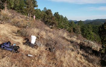
Research in Gordon Gulch, Colo., part of NSF's Boulder Creek Critical Zone Observatory.
Credit: Suzanne Anderson, University of Colorado at Boulder
Download the high-resolution JPG version of the image. (963 KB)
See a video of "Where Rock Meets Life" in Boulder Creek, Colo.
Credit: NSF Boulder Creek Critical Zone Observatory
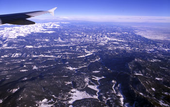
Bird's eye view: Boulder Creek and the Rocky Mountains from the skies above.
Credit: Robert Anderson, University of Colorado at Boulder
Download the high-resolution JPG version of the image. (1.9 MB)
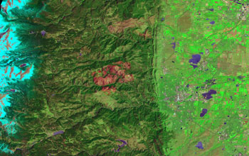
Location of Boulder Creek, and tributary Fourmile Creek, with red burn scar from a wildfire
Credit: NASA
Download the high-resolution JPG version of the image. (2.5 MB)
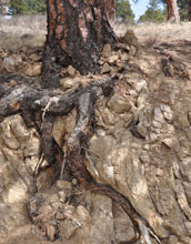
A tree grows near Boulder Creek: a ponderosa pine extends its roots into rock below.
Credit: Suzanne Anderson, University of Colorado at Boulder
Download the high-resolution JPG version of the image. (2.8 MB)
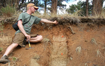
Scientist Ken Nelson studies the soils beneath trees at the Boulder Creek CZO.
Credit: Suzanne Anderson, University of Colorado at Boulder
Download the high-resolution JPG version of the image. (1.9 MB)

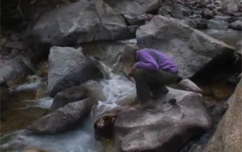
Researcher T. Joe Mills samples winter snows in the Boulder Creek watershed.
Credit: Suzanne Anderson, University of Colorado at Boulder
Download the high-resolution JPG version of the image. (64 KB)
The following is part four in a series on the National Science Foundation's Critical Zone Observatories (CZOs). Part one describes the work of the Susquehanna Shale Hills CZO. Part two focuses on the Southern Sierra CZO. Part three highlights research at the Christina River Basin CZO.
Fire and water. One scorches the other, only to be drowned in return. Could their effects on a watershed be related?
Scientists
conducting research in Colorado's Rocky Mountains at the National
Science Foundation (NSF) Boulder Creek Critical Zone Observatory (CZO)
are finding out.
Boulder Creek is a 31-mile-long stream draining
the Rocky Mountains to the west of Boulder, Colo., as well as the city
itself and surrounding plains.
At the Boulder Creek CZO,
scientists see fire and water as being closely tied to the
landscape--and to what's below that landscape in the subsurface
environment.
"Ultimately, it's the landscape that controls where
fires are most likely," says scientist Suzanne Anderson of the
University of Colorado at Boulder, director of the Boulder Creek CZO.
"It all begins with the presence of the mountains," she says, "with the landscape beneath the forests and streams."
The Colorado Front Range, whose mountains Boulder Creek plummets down, are the stage upon which fire, water and forests are set.
Take
the Fourmile Canyon Fire of September 2010. It burned 6,400 acres,
destroyed 169 homes and caused more than $217 million in damages.
The
wildfire raged through the Boulder Creek watershed's rugged terrain.
The resulting deforestation, CZO scientists have found, left the area at
risk of flooding and erosion, including debris flows from the fire.
NSF's Critical Zone Observatories: where rock meets water meets life
The Boulder Creek CZO is one of six NSF CZOs in watersheds across the nation.
In
addition to the Boulder Creek site, CZOs are located in the Southern
Sierra Nevada, Christina River Basin on the border of Delaware and
Pennsylvania, Susquehanna Shale Hills in Pennsylvania, Luquillo riparian
zone in Puerto Rico, and the Jemez River and Santa Catalina Mountains
in New Mexico and Arizona.
They're providing researchers with a
new understanding of the critical zone--the region between the top of
the forest canopy and the base of unweathered rock.
"The critical
zone is our living environment," says Enriqueta Barrera, program
director in NSF's Division of Earth Sciences, which funds the CZO
network. "The CZOs offer us new knowledge about the critical zone and
its response to climate and land-use change."
They're the first
systems-based observatories dedicated to understanding how Earth's
surface processes are coupled, she says. "They will help us predict how
the critical zone affects the ecosystem services on which society
depends."
The water cycle, the breakdown of rocks and eventual
formation of soil, the evolution of rivers and valleys, patterns of
plant growth and landforms all result from processes that take place in
the critical zone.
"The CZOs," says Barrera, "are fostering a new view of the critical zone as one holistic system."
Fast-moving water--and fire--in the critical zone
What are the long-term effects of the Fourmile Canyon Fire and other wildfires on watersheds such as Boulder Creek?
Studies
of streams after wildfires have yielded conflicting results. Some show
increases in pH (water that's more basic vs. acidic), turbidity,
nutrients, sulfate and metals. Other research reports few effects.
"Many
of these studies sampled water chemistry at intervals that didn't catch
rapid changes," says Anderson. "At the Boulder Creek CZO, we're
conducting high-frequency stream sampling, and evaluating how upland
hydrologic and biogeochemical processes affected by fire influence
downstream water quality."
Since the Fourmile Canyon Fire,
scientists at the Boulder Creek CZO and the U.S. Geological Survey have
been tracking discharge rates, nutrients, metals and ecosystem
characteristics such as numbers and species of invertebrates that live
in streams.
Runoff from burned north- and south-facing slopes is being measured to assess how hillslopes respond differently following fire.
Instruments
have been placed on the hillslopes, and in soils along Boulder Creek's
banks, to record changes. Stream water and soil chemistry are being
compared with those of nearby unburned areas.
Monitoring continues during snowmelt when water levels are high, and during "gully washer" summer thunderstorms.
In
the summer of 2011, for example, a severe storm led to an 8,100 percent
increase in stream discharge in Fourmile Creek, a tributary of Boulder
Creek. "That was some three times higher than had ever been measured,"
says Anderson.
The storm flooded homes and blocked roads with
sediment. It also resulted in concentrations of in-stream total
suspended solids that were 4,000-fold above baseline.
Some of that sediment remains in the creek channel, then flows downstream when more rain falls in the area.
"Such
precipitation events can lead to catastrophic erosion that affects
long-term sediment loads," says Anderson. "Increases in turbidity,
nitrate and what's called dissolved organic carbon in turn may affect
drinking water treatment processes."
These studies are but a few
of "many taking place at the Boulder Creek CZO on everything from how
the 'architecture' of the critical zone affects its hydrology, to the
role trees play in the critical zone's evolution," says Anderson.
The Front Range: a regional water tower
With
its high peaks, the Colorado Front Range "harvests" precipitation from
the atmosphere. Most of that precipitation falls as snow. The snowpack
becomes a reservoir, and the mountains act as a water tower.
"The
distribution of water resources in western North America is actually
controlled by the geologic history of the region," says Anderson. "It
sets the location, height and width of the moisture-trapping and
moisture-holding mountain ranges."
Forests near Boulder Creek--and
everywhere in the West--are found in mountain ranges. Moisture is high
enough there for trees to flourish, and precipitation evaporates more
slowly.
But where forests grow, fires often aren't far behind.
"With more droughts in recent years," says Anderson, "we're more at risk
of fires."
The role of erosion
The Front Range--more than 10,000 feet high at its crest--is eroding, says Anderson, but very slowly.
For
the most part, "it's cool and moist there," she says, "and
'soil-mantled'--the soil wasn't scraped away by the glaciers that
covered the region in the distant past."
Most of this slowly eroding terrain has been sliced by rivers, which have hollowed out deep canyons such as Boulder Canyon.
"The
canyons are giant drains carved into the terrain," says Anderson. "They
lower the water table of surrounding slopes. Their erosion history sets
up broad regions of well-drained forested landscape."
That well-drained landscape is the corridor where big fires, such as the one in Fourmile Canyon, have happened.
"The topography of the Front Range is interconnected with water and fire in the landscape," says Anderson.
Past is prologue?
At
Boulder Creek, scientists are looking down into the subsurface,
Anderson says, "to understand how the landscape evolved into its present
state, and how that controls everything from where forests are found,
to how fast weathering of subsurface rock takes place, to a watershed's
ability to collect and store water." And, perhaps, to put a fire out.
Meanwhile, the creek flows onward, cutting into the mountain landscape as it goes--and carrying parts of the Rockies with it.
"Amber and white and black in the arrested spaces," wrote H.H. Jackson in 1878 in Bits of Travel at Home,
"[Boulder Creek] whirls under bridges and round the corners, doubles on
itself, leaps over and high above a hundred rocks in a rod, breaks into
sheafs and showers of spray, foams and shines and twinkles and
glistens; and if there be any other thing which water at its swiftest
and sunniest can do, that it does also, even to jumping rope with
rainbows."
A perfect description, says Anderson, of the role of fast-flowing streams in the critical zone.
| -- | Cheryl Dybas, NSF (703) 292-7734 cdybas@nsf.gov |
Related Websites
NSF Critical Zone Observatories: Where Rock Meets Life: http://www.criticalzone.org/
NSF Boulder Creek Critical Zone Observatory: http://czo.colorado.edu/
NSF Awards Grants for Three Critical Zone Observatories:
NSF Critical Zone Observatories: Where Rock Meets Life: http://www.criticalzone.org/
NSF Boulder Creek Critical Zone Observatory: http://czo.colorado.edu/
NSF Awards Grants for Three Critical Zone Observatories:
http://www.nsf.gov/news/news_summ.jsp?cntn_id=110586
NSF Science, Engineering and Education for Sustainability Investment:
NSF Science, Engineering and Education for Sustainability Investment:
http://www.nsf.gov/sees
NSF Discovery Article: Science on the Graveyard Shift:
NSF Discovery Article: Science on the Graveyard Shift:
http://www.nsf.gov/discoveries/disc_summ.jsp?cntn_id=125882&org=NSF
NSF Discovery Article: A Tree Stands in the Sierra Nevada:
NSF Discovery Article: A Tree Stands in the Sierra Nevada:
http://www.nsf.gov/discoveries/disc_summ.jsp?cntn_id=125091&org=NSF
NSF Discovery Article: Can Marcellus Shale Gas Development and Healthy Waterways Sustainably Coexist?: http://www.nsf.gov/discoveries/disc_summ.jsp?cntn_id=122543
NSF Discovery Article: Can Marcellus Shale Gas Development and Healthy Waterways Sustainably Coexist?: http://www.nsf.gov/discoveries/disc_summ.jsp?cntn_id=122543
The National Science Foundation.
Guillermo Gonzalo Sánchez Achutegui
ayabaca@gmail.com
ayabaca@hotmail.com
ayabaca@yahoo.com
Inscríbete en el Foro del blog y participa : A Vuelo De Un Quinde - El Foro!

No hay comentarios:
Publicar un comentario