Mount Pinatubo eruption predated start of satellite observation record
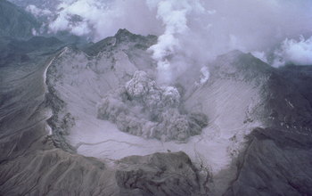 Mount Pinatubo's 1991 eruption and its effects masked sea level rise. Credit and Larger Version |
August 10, 2016
The cataclysmic 1991 eruption of Mount Pinatubo in the Philippines masked the full impact of greenhouse gases on accelerating sea level rise, according to a new study.
"These scientists have disentangled the major role played by the volcanic eruption of Mount Pinatubo on trends in global mean sea level," said Anjuli Bamzai, program director in the National Science Foundation's Division of Atmospheric and Geospace Sciences, which funded the research. "This research is vital as society prepares for the potential effects of climate change."
Satellite observations of the ocean surface, which began in 1993, indicated the rate of sea level rise was holding fairly steady at about 3 millimeters per year. As the pace of warming oceans and melting glaciers and ice sheets accelerated, scientists expected to see a corresponding increase in the rate of sea level rise. Analysis of the satellite record has not borne that out, however.
Researchers have now determined that the expected increase in sea level rise due to climate change was likely hidden because of a happenstance of timing: Pinatubo erupted in 1991, two years before the first satellite observations of the ocean began. The eruption, which temporarily cooled the planet, caused sea levels to drop and effectively distorted calculations of sea level rise in subsequent decades.
The study lends support to climate model projections that show the rate of sea level rise escalating over time as the climate warms. The findings were published today in the open-access journal Scientific Reports, published by Nature Publishing Group.
"When we used climate model runs designed to remove the effect of the Pinatubo eruption, we saw the rate of sea level rise accelerating in our simulations," said National Center for Atmospheric Research (NCAR) scientist John Fasullo, who led the study. "Now that the impacts of Pinatubo have faded, this acceleration should become evident in the satellite measurements in the coming decade, barring another major volcanic eruption."
Study co-author Steve Nerem of the University of Colorado Boulder, added: "The study shows that large volcanic eruptions can significantly impact the satellite record of global average sea level change. So we must be careful to consider these effects when we look for the effects of climate change in the satellite-based sea level record."
The findings have implications for the extent of sea level rise this century and may be useful to coastal communities planning for the future. Decision-makers have debated whether communities should make plans based on the steady rate of sea level rise as measured by satellites in recent decades, or based on the accelerated rate expected in the future as predicted by climate scientists.
Reconstructing a pre-Pinatubo world
Fasullo and Nerem, along with Benjamin Hamlington of Old Dominion University, wanted to pin down how quickly sea levels were rising in the decades before the satellite record began.
Prior to the launch of the international TOPEX/Poseidon satellite mission in late 1992, sea level was mainly measured using tide gauges. For the researchers, variations in measurement technique and location meant that the pre-satellite record was best used to get a ballpark estimate of global mean sea level.
To complement the historic record, the research team ran the NCAR-based Community Earth System model 40 times with slightly different -- but historically plausible -- starting conditions. The resulting simulations characterize the range of natural variability in the factors that affect sea levels. The model was run on the Yellowstone system at the NCAR-Wyoming Supercomputing Center.
A separate set of model runs that omitted volcanic aerosols -- particles spewed into the atmosphere by an eruption -- was also assessed. By comparing the two sets of runs, the scientists were able to pick out a signal (in this case, the effect of Mount Pinatubo's eruption) from the noise (natural variations in ocean temperature and other factors that affect sea level).
"You can't do it with one or two model runs -- or even three or four," Fasullo said. "There's just too much accompanying climate noise to understand precisely what the effect of Pinatubo was. We could not have done it without large numbers of runs."
Using models to understand observations
Analyzing the simulations, the research team found that Pinatubo's eruption caused the oceans to cool and sea levels to drop by about 6 millimeters immediately before TOPEX/Poseidon began making observations.
As the sunlight-blocking aerosols from Mount Pinatubo dissipated in the simulations, sea levels began to slowly rebound to pre-eruption levels. This rebound swamped the acceleration caused by the warming climate and made the rate of sea level rise higher in the mid- and late 1990s than it otherwise would have been.
This higher-than-normal rate of sea level rise in the early part of the satellite record made it appear as though the rate of sea level rise was not accelerating over time. In fact, according to the study, if the Pinatubo eruption had not occurred -- leaving sea level at a higher starting point in the early 1990s -- the satellite record would have shown a clear acceleration.
"The satellite record is unable to account for everything that happened before the first satellite was launched," Fasullo said. "This study is a great example of how computer models can give us the historical context that's needed to understand some of what we're seeing in the satellite record."
Understanding whether the rate of sea level rise is accelerating or remaining constant is important because it drastically changes what sea levels might look like in 20, 50 or 100 years.
Because the study's findings suggest that acceleration due to climate change is already under way, the acceleration should become evident in the satellite record in the coming decade, Fasullo said.
Since the original TOPEX/Poseidon mission, newer satellites, including the recently launched Jason-3, will continue to track sea level.
"Sea level rise is potentially one of the most damaging effects of climate change, so it's critical that we understand how quickly it will rise in the future," Fasullo said. "Measurements from Jason-3 will help us evaluate what we've learned in this study and help us better plan for the future."
NASA and the U.S. Department of Energy also funded the study.
-NSF-
Media Contacts Cheryl Dybas, NSF, (703) 292-7734,
cdybas@nsf.gov
Laura Snider, NCAR, (303) 497-8605,
lsnider@ucar.eduLaura Snider, NCAR, (303) 497-8605,
The National Science Foundation (NSF) is an independent federal agency that supports fundamental research and education across all fields of science and engineering. In fiscal year (FY) 2016, its budget is $7.5 billion. NSF funds reach all 50 states through grants to nearly 2,000 colleges, universities and other institutions. Each year, NSF receives more than 48,000 competitive proposals for funding and makes about 12,000 new funding awards. NSF also awards about $626 million in professional and service contracts yearly.
Useful NSF Web Sites:
NSF Home Page:
https://www.nsf.gov
NSF News:
https://www.nsf.gov/news/
For the News Media:
https://www.nsf.gov/news/newsroom.jsp
Science and Engineering Statistics:
https://www.nsf.gov/statistics/
Awards Searches:
https://www.nsf.gov/awardsearch/

Earth, with a sea level rise of 19.7 feet. Imagine a possible future rise of several times that.
Credit and Larger Version

How far will sea levels rise? The rate is increasing over time.
Credit and Larger Version

Sea level rise puts wetlands along U.S. coastlines and around the world at risk.
Credit and Larger Version

Virginia Beach and other cities and towns built on barrier islands may be swamped by rising seas.
Credit and Larger Version

Louisiana's coast is underwater in this simulation of rising seas.
Credit and Larger Version
The National Science Foundation (NSF)
Guillermo Gonzalo Sánchez Achutegui
ayabaca@gmail.com
ayabaca@hotmail.com
ayabaca@yahoo.com
Inscríbete en el Foro del blog y participa : A Vuelo De Un Quinde - El Foro!

No hay comentarios:
Publicar un comentario