https://www.nasa.gov/topics/earth/features/yellowstone-heat.html
 ISTOCK
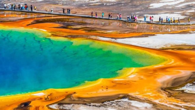
Dormido bajo los tranquilos paisajes del parque nacional de Yellowstone, en Estados Unidos, se esconde uno de los mayores misterios geológicos del mundo.
Es una enorme cámara de lava volcánica, un río de magma responsable de los géiseres y aguas termales que caracterizan el área.
Pero para los científicos de la NASA, es también una de las más preocupantes amenazas naturales para la civilización humana.
Es, en realidad, un supervolcán, el mayor de todos cuantos existen en el planeta, el más peligroso. Pero no el único.
El peligro de los supervolcanes
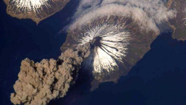
Hay alrededor de 20 supervolcanes conocidos en la Tierra, con grandes erupciones que ocurren en promedio cada 100.000 años.
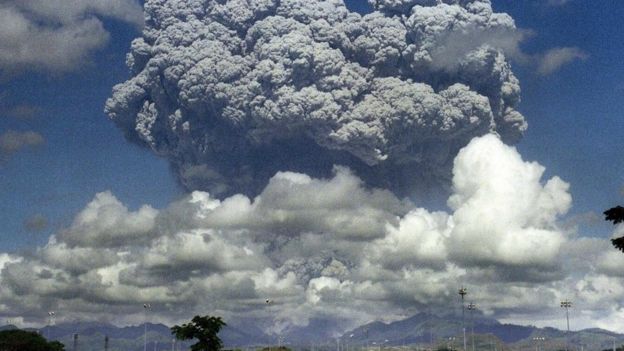
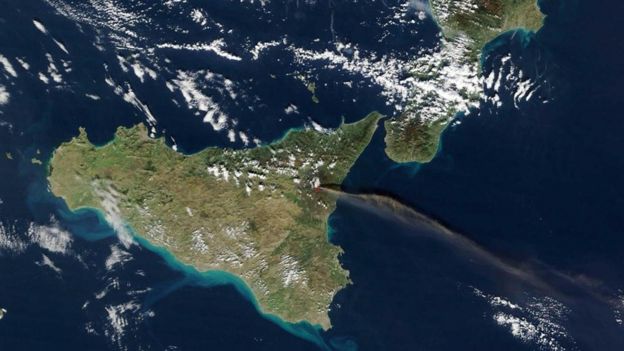
Uno de sus mayores peligros es que una erupción puede provocar un "invierno volcánico" prolongado, una nube de ceniza que trastoca el clima e impide a la civilización de tener suficiente acceso a los recursos naturales y a la comida.
(Prevenir la erupción del supervolcán de Yellowstone) requiere que la comunidad científica invierta el poder de su mente, pero tiene que hacerlo ya"
En 2012, Naciones Unidas estimó que las reservas de alimentos en todo el mundo durarían solo 74 días.
Es por eso que, para la NASA, Yellowstone representa un peligro mayor que cualquier otro que pueda venir desde el espacio.
"Yo era miembro del Consejo Asesor de Defensa Planetaria de la NASA, un grupo que estudiaba formas de defender el planeta de asteroides y cometas. Pero llegué a la conclusión de que la amenaza de un supervolcán es sustancialmente mayor ", le explica a BBC Future Brian Wilcox, del Laboratorio de Propulsión a Chorro de la NASA en el Instituto de Tecnología de California.
Por eso, la agencia espacial estadounidense se puso manos a la obra desde hace años para enfrentar el problema.
La estrategia de la NASA
Cuando los científicos de la NASA comenzaron considerar la amenaza y buscarle respuestas, pensaron que la solución más lógica podría ser, simplemente, enfriar el supervolcán, de arriba hacia abajo.
¿En qué consiste esa extraña idea?
Un volcán del tamaño de Yellowstone es, esencialmente, un generador gigantesco de calor, equivalente a seis plantas industriales de energía.
En la actualidad, Yellowstone filtra hacia la atmósfera aproximadamente el 60-70% del calor que produce a través del agua que se cuela por las grietas de la cámara del magma.
El resto se acumula dentro de la lava, lo que actúa como combustible para disolver más y más gases volátiles y rocas circundantes.
 GETTY IMAGES
Cuando este calor alcanza un determinado umbral, una erupción es inevitable.
Pero si se pudiera extraer más calor, entonces el supervolcán nunca entraría en erupción.
La NASA estima que si lograra reducir en un 35% el calor que se genera dentro de la cámara de magma, Yellowstone ya no representaría una amenaza.
La pregunta es cómo hacerlo.
Acueducto volcánico
La primera alternativa, según la NASA, estaría simplemente en aumentar la cantidad de agua que se filtra hacia el interior del .
Pero desde una perspectiva práctica, sería tal vez imposible convencer a los políticos de aprobar tal iniciativa.
"Construir un gran acueducto cuesta arriba en una región montañosa sería costoso y difícil con la crisis del agua a nivel internacional; no creo que a la gente le agrade la idea de desperdiciarla para enfriar un volcán", asegura Wilcox.
En cambio, la NASA propuso perforar hasta 10km hacia las entrañas del supervolcán y bombear el agua a alta presión.
El líquido en circulación volvería a la superficie en forma de vapor, a una temperatura de alrededor de 350 °C. Así, lentamente, día por día, se extraería calor del volcán.
A simple vista, podría parecer un proyecto similar al anterior. Si a eso le añadimos que costaría alrededor de US$3.500 millones, es sencillo imaginar que la idea podría quedar también en la nada.
Pero la agencia espacial encontró una atractiva solución para convencer a los políticos de hacer la inversión.
"Yellowstone actualmente gotea alrededor de 6 gigavatios en calor. Con la perforación, esto podría ser utilizado para crear una planta geotérmica, que geneRAría energía eléctrica a precios muy competitivos de alrededor de US$0,10/kWh", asegura Wilcox.
 GETTY IMAGES
Para este investigador, la solución permitiría recuperar la inversión inicial, generaría electricidad suficiente para alimentar el área circundante durante un período potencial de decenas de miles de años y se evitarían futuras erupciones de supervolcán que devastaría a la humanidad.
Riesgos
Pero la perforación de un supervolcán no vendría sin ciertos riesgos. De hecho, podría desencadenar la erupción que desea prevenir.
En otras palabras, podría despertar al monstruo que duerme hace miles y miles de años.
¿Qué hacer entonces?
"Lo más importante es no hacer daño a la estructura de la cámara de magma. Si perforas en la parte superior de la cámara y tratas de enfriar desde allí, esto sería muy arriesgado", sostiene Wilcox.
En opinión del experto, eso podría hacer que la tapa sobre la cámara del magma se vuelva más frágil y propensa a la fractura. Así sería más fácil que se active la liberación de gases volátiles nocivos.
Por eso, la idea es perforar el supervolcán desde sus laterales, que se encuentran incluso fuera de los límites de Yellowstone.
Sin embargo, aquellos que inviertan o trabajen en el proyecto no vivirán para saber si dio resultado o no. Ni siquiera lo verán terminado.
El enfriamiento de Yellowstone de esta manera ocurriría a una velocidad de un metro por año, por lo que tardaría decenas de miles de años hasta que la cámara de magma se convirtiera en una masa de roca fría.
Pero aunque la cámara de Yellowstone no necesitaría ser congelada totalmente para llegar al punto en el que ya no represente una amenaza, no habría tampoco garantías de que el esfuerzo finalmente tendría éxito por lo menos durante cientos y posiblemente miles de años.
Entonces, ¿para qué hacerlo?
Los beneficios de domar el volcán
Según Wilcox, los beneficios de esta estrategia a largo plazo no solo incluirían la posibilidad de domar al volcán, sino también que garantizaría en términos cotidianos una nueva fuente de suministro de energía eléctrica.
 GETTY IMAGES
Tal plan podría aplicarse potencialmente a cada supervolcán activo en el planeta y los expertos de la NASA esperan que estas ideas fomenten también un debate científico más práctico para abordar la amenaza.
"Cuando la gente consideró por primera vez la idea de defender la Tierra del impacto de asteroides, reaccionaron de manera similar a la amenaza de un supervolcán", sostiene Wilcox.
"La gente pensó: ¿cómo pueden los humanos impedir que un asteroide golpee la Tierra? Bueno, resulta que si inventas algo que empuje al asteroide muy ligeramente durante mucho tiempo, puedes hacerlo cambiar de rumbo".
Por eso, Wilcox considera que resolver el problema de la amenaza de los supervolcanes resulta más fácil de lo que la gente piensa.
"En ambos casos requiere que la comunidad científica invierta el poder de su mente, pero tiene que hacerlo ya. Yellowstone hace erupción aproximadamente cada 600.000 años y hace unos 600.000 años desde que lo hizo por última vez", explica.
La cuenta regresiva ha comenzado.
Contenido relacionado
Landsat satellites Track Yellowstone's Underground Heat :
Yellowstone National Park sits on top of a vast, ancient, and still active
volcano. Heat pours off its underground magma chamber, and is the fuel for
Yellowstone’s famous features -- more than 10,000 hot springs, mud pots,
terraces and geysers, including Old Faithful.
But expected development by
energy companies right outside Yellowstone’s borders have some fearing that Old
Faithful could be cheated out of its energy.
"If that geothermal
development outside of the park begins, we need to know whether that's going to
cause Old Faithful to suddenly stop spewing," says Rick Lawrence of Montana
State University.
Geothermal energy development is here to stay, says
Yellowstone Park geologist Cheryl Jaworowski, but it has also raised some big
questions for the National Park Service, which is tasked by Congress to monitor
and protect Yellowstone's unique landscape.
 Yellowstone National Park is outlined by
red in each of the Landsat scenes. On the left is a true color image with
vegetation shown in green. On the right, is the thermal image with higher heat
emitted shown in white. (Credit: NASA's Goddard Space Flight Center)
Yellowstone National Park is outlined by
red in each of the Landsat scenes. On the left is a true color image with
vegetation shown in green. On the right, is the thermal image with higher heat
emitted shown in white. (Credit: NASA's Goddard Space Flight Center)
The park funded a study by Lawrence and
his co-author Shannon Savage to apply a new perspective to the problem of
tracking geothermal activity. Their work is being presented at the American
Geophysical Union conference in San Francisco on Friday, December 9. Lawrence
and Savage used both visible light and heat-sensitive Landsat data channels to
get a broad view of the park’s geothermal activity.
Their project is part
of a new monitoring plan the park implemented in 2005. The plan uses remote
sensing and airborne reconnaissance to observe geothermal changes across all of
Yellowstone in a systematic and scientific manner. In the past, scientific
studies on the ground tended to focus on individual features, and the only park
wide estimate of Yellowstone's heat was derived from a chemical product of
geothermal systems that appears in the river system. But with different
technology available today, says Jaworowski, the park wants to expand its
monitoring options.
To understand Yellowstone's geothermal system, "we
need to start looking at the forest rather than the individual trees," says
Jawrorski. And one way to see Yellowstone's geothermal "forest" is to get a view
from space.
Circling Earth from a height of 438 miles, the Landsat
satellites have been gathering for decades a huge amount of data about the land
surface. A single scene can take in the entirety of Yellowstone National Park,
and the data it gathers is much more than a pretty picture. In addition to
measuring the visible light in the electromagnetic spectrum -- what we can see
-- the Landsat satellites each have an instrument that detects waves in the
thermal band -- heat energy.
Earth radiates heat all the time because it
is warmed by the sun. Like a sponge, the ground absorbs solar energy, and like
when you squeeze off excess water, the Earth reemits some of that solar energy
at a longer wavelength back into space. But in Yellowstone, the total energy
picked up by the satellite includes energy produced by the Earth itself,
geothermal energy.

Minerva Terrace and Spring, part of Mammoth Hot
Springs in Yellowstone National Park, photographed in 1963. Credit:
National Park Service
› Larger
image “It’s very hard to tease out the geothermal energy,” says
Lawrence. The amount of solar energy reemitted depends on air temperature,
vegetation cover, and soil moisture among other variables, and geothermal energy
is only a small fraction of the total. To estimate changes in the geothermal
system, Lawrence and Savage looked back in time and selected one image per year
from 1986 to 2007 (with a few gaps due to cloudy days). Because solar effects
vary from year to year and with weather conditions, they subtracted out the
average heat emitted from the surface of Yellowstone for each year. The observed
changes from year to year would then be primarily attributable to geothermal
changes. The scientists then compared these images with known geothermal events
during that time period.
Minerva Terraces in the Mammoth Basin was one
of those geothermal events. In 1998, mineral-rich, near-boiling water bubbled
over the Minerva's broad steps, depositing calcite on the face of each terrace.
Heat-loving organisms colored the white surface a dozen shades of pink, yellow,
and green. A year later, the Terraces were a ghost town. "There was no steam, no
color, and then it started crumbling away because it was very soft calcite,"
says Savage. Minerva’s colorful ecosystem collapsed when the hot water stopped
flowing.
That collapse was reflected in the satellite data Lawrence says.
In the Landsat scenes from 1998 and 1999, "the amount of energy coming off the
Minerva Terrace area went down."
 This series of geothermal emittance data from the
Mammoth Hot Springs area shows a general trend of increased emittance to 2000,
and then decreased emittance from 2000 to 2007. This general trend occurred in
all sites in the study and is thought to be part of a larger cyclical trend of
uplift and subsidence of the hot magma beneath Yellowstone. (Credit: Shannon
Savage)
This series of geothermal emittance data from the
Mammoth Hot Springs area shows a general trend of increased emittance to 2000,
and then decreased emittance from 2000 to 2007. This general trend occurred in
all sites in the study and is thought to be part of a larger cyclical trend of
uplift and subsidence of the hot magma beneath Yellowstone. (Credit: Shannon
Savage)
But not all the changes were expected. A lone
hiker on a boardwalk at Jewel Geyser snapped a picture of rocks flying
everywhere in a geothermal explosion. But in the Landsat data where the
scientists would have expected more heat, "the temperature actually went down,
then it went back up afterward," says Lawrence. At the time no ground
temperature measurements were made so the science team doesn't know
why.
What this means for real-time monitoring at this stage of the
project, says Lawrence, is that the satellite data can tell Park managers when
big changes occur in a geothermal area, but not necessarily what is happening,
or exactly where. Landsat thermal pixels used in this study are 120 meters on a
side, much bigger than many of Yellowstone’s geothermal landmarks, many of which
can be as small or smaller than a one meter.
This relatively large pixel
size is one of the limiting factors on Landsat's usefulness, says Savage. Many
small events, like a hiking trail to Beaver Ponds that disappeared by Narrow
Gauge Spring in the summer of 1998, are too small to appear in the Landsat data.
Despite these uncertainties, Landsat data’s long-term record, going back
to 1984, gives scientists clues as to how geothermal events could be
interconnected underground. If two areas tend to change in similar patterns,
that suggests they might share the same plumbing. While geothermal sites outside
the park were outside Lawrence and Savage’s study area, by using this type of
analysis, scientists may be able to see if there are -- or are not -- any
connections to areas inside the park. For example, two areas that were long
thought to be connected, the Norris Geyser Basin and Mammoth Hot Springs, did
not show any similar trends and so may not be connected underground in any
way.
Using satellites to monitor changes in Yellowstone's geothermal
activity is still in its early stages, says Park geologist Cheryl Jaworowski.
"We have some initial numbers but a lot more work needs to be done," she says,
particularly in further resolving geothermal from solar energy, which remains
one of the biggest challenges. One thing she wants to try is to take Landsat
thermal scenes at night to try to reduce the amount of solar energy obscuring
the geothermal signal.
If they can resolve that problem and perhaps
eventually get higher resolution thermal data in the future, Savage says that
Landsat as a monitoring tool has a lot of potential. The next Landsat satellite,
the Landsat Data Continuity Mission is scheduled to launch in early 2013, and it
has a new thermal instrument that will add to the Yellowstone geothermal record
in the coming decade.
The Landsat Program is a series of Earth
observing satellite missions jointly managed by NASA and the U.S. Geological
Survey. Landsat satellites have been consistently gathering data about our
planet since 1972. They continue to improve and expand this unparalleled record
of Earth's changing landscapes for the benefit of all.
For more
information on Landsat, visit:
Ellen Gray
NASA's Earth
Science News TeamGuillermo Gonzalo Sánchez Achutegui
ayabaca@gmail.com
ayabaca@hotmail.com
ayabaca@yahoo.com
Inscríbete en el Foro del blog y participa : A Vuelo De Un Quinde - El Foro!