Mostrando entradas con la etiqueta Wyoming. Mostrar todas las entradas

viernes, 28 de septiembre de 2018

YELLOWSTONE : NATIONAL GEOGRAPHIC .- MEDIO AMBIENTE .- Yellowstone, el primer Parque Nacional del mundo ............... Yellowstone, el emblemático parque norteamericano

Hola amigos: A VUELO DE UN QUINDE EL BLOG., la Revista National Geographic, nos halaga con un importante despliegue de fotografías del Parque Nacional de Yellowstone, que viene hacer el parque emblemático de Los Estados Unidos de América, por su riqueza en flora, fauna y sus géiseres y cañones únicos en el mundo, aquí todo es gigantesco, por que su atractivo principal es su caldera volcánica.
National Geographic .- dice : "Situado entre los estados de Wyoming, Montana y una pequeña porción de Idaho, Yellowstone abarca casi 9.000 kilómetros cuadrados –algo más que la Comunidad de Madrid– y dispone de cinco entradas. Por el acceso Sur se llega a Grant Village, localidad con todos los servicios instalada a orillas del lago Yellowstone. La riqueza geológica del parque empieza a manifestarse al poco de dejar Grant Village rumbo oeste, en la minicaldera West Thumb Pool. A pesar de ser una de las más pequeñas del parque, contiene manantiales de aguas termales, pozas de barro hirviendo, géiseres y fumarolas...."
National Geographic.- añade : " La carretera que conduce a Old Faithful cruza la región de Geyser Country, donde se localizan 180 de los 300 géiseres de la reserva. Varios senderos circulan entre estas fuentes que expulsan columnas de agua caliente, con el géiser Old Faihtful como gran atractivo por la altura que alcanza, entre 30 y 60 metros...."

https://www.nationalgeographic.com.es/viajes/grandes-reportajes/yellowstone-el-emblematico-parque-norteamericano_6502/1
Un itinerario circular entre los géiseres y cañones de esta gigantesca caldera volcánica del noroeste de Estados Unidos

https://www.nationalgeographic.com.es/fotografia/foto-del-dia/yellowstone-primer-parque-nacional-mundo_10075
«Hoy me hallo en Yellowstone, y quiero morirme.» Así describía Rudyard Kipling en un relato de 1889 su estancia en el parque más antiguo del mundo

Parque Nacional de Yellowstone, Estados Unidos

Yellowstone, el primer Parque Nacional del mundo
«Hoy me hallo en Yellowstone, y quiero morirme.» Así describía Rudyard Kipling en un relato de 1889 su estancia en el parque más antiguo del mundo. Su crítica se debía sobre todo a la «muchedumbre vociferante» de turistas con la que compartió su visita. Maravillas como el géiser Old Faithful - en la imagen- atraen hoy a más de tres millones de visitantes al año; la mayoría no se aventura a más de cien metros de las carreteras asfaltadas.
Si Kipling se hubiese adentrado en los 8.992 kilómetros cuadrados del parque para admirar el esplendor de sus valles fluviales y prados de montaña, tal vez su lamento se habría convertido en loa.
Yellowstone, naturaleza a la americana
Más información

Naturaleza a la americana

10
Fotografías
 Redacción
20 de septiembre de 2018

Yellowstone, el emblemático parque norteamericano

Un itinerario circular entre los géiseres y cañones de esta gigantesca caldera volcánica del noroeste de Estados Unidos

Lower Falls
Vierte las aguas del río Yellowstone en un profundo cañón desde una altura de 93 metros. A mediados del siglo XIX, fotógrafos y pintores las dieron a conocer al resto del país.
AVRAHAM KUSHNIROV / AGE FOTOSTOCK

West Thumb
Esta laguna de agua hirviendo es el primer contacto con la actividad termal del parque si se accede por el sur.
DOMINIQUE DELFINO / GTRES

Geyser Country
La carretera principal pasa junto a los grandes enclaves de esta región de géiseres y ríos caudalosos como el Madison.
M& J MILLER / AGE FOTOSTOCK

El reino de la fauna
Yellowstone no es únicamente un paraíso natural por sus bosques, ríos y lagunas termales, sino también por albergar la gran fauna de las montañas Rocosas. La constitución en parque nacional a finales del siglo XIX y la declaración de Reserva de la Biosfera por parte de la Unesco en 1976, contribuyeron enormemente a la conservación del hábitat de osos, wapitis, pumas, linces y alces, los denominados big five. Fotografiarlos es el mayor trofeo del viaje por esta reserva.
ANTONIO VAZQUEZ

Canyon Country
El paisaje que envuelve el cañón del río Yellowstone, con las cascadas Lower y Upper Falls, es uno de los más identificativos de las Rocosas estadounidenses.
HENRYK SADURA / AGE FOTOSTOCK

Grand Prismatic
Un anillo de tonos ocres, que van del amarillo al naranja, rodea la laguna de aguas termales
JEFF VANUGA / CORBIS

Mammoth Hot Springs
Un circuito de sendas sobre pasarelas recorre las distintas zonas de terrazas calcáreas. El centro de visitantes, un edificio de 1900, explica el origen de este espacio.
MICHELE FALZONE / ACI

Mamoth Hot Springs
Es la región del parque más antigua en cuanto a actividad térmica. En la imagen, las plataformas calcáreas de Angel Terrace.
ADAM JONES / AGE FOTOSTOCK
 
Las cinco regiones del parque Yellowstone
1 Lake Country. Es la zona que se extiende en torno al lago Yellowstone. Lake Village y Grant Village son sus centros de visitantes.
2 Geyser Country. Se accede por Grant Village y por Madison. West Thumb Pool, Grand Prismatic y Old Faithful son sus atractivos más famosos.
3 Canyon Country. Las estrellas de esta región son el cañón del río Yellowstone y las cataratas Upper y Lower Falls.
4 Roosevelt Country. Abarca el norte del parque, una zona de praderas y bosques con gran abundancia de fauna.
5 Mammoth Hot Springs. Zona de manantiales termales.
Mapa: BLAUSET
Diego Sáinz
6 de noviembre de 2012
 
Yellowstone, el emblemático parque norteamericano
Yellowstone, el parque nacional más antiguo del mundo (1872), es una gran caldera volcánica que concentra un sinfín de fenómenos geotérmicos, dos tercios de los géiseres del planeta y numerosas fuentes calientes. Pero además, el recorrido por sus cinco regiones descubre que es el hogar de osos negros y grizzlys, coyotes, lobos, alces y ciervos canadienses o wapitis, así como de manadas de bisontes.
Más información

El Parque de Adirondack, al norte de Nueva York

15
Fotografías
Situado entre los estados de Wyoming, Montana y una pequeña porción de Idaho, Yellowstone abarca casi 9.000 kilómetros cuadrados –algo más que la Comunidad de Madrid– y dispone de cinco entradas. Por el acceso Sur se llega a Grant Village, localidad con todos los servicios instalada a orillas del lago Yellowstone. La riqueza geológica del parque empieza a manifestarse al poco de dejar Grant Village rumbo oeste, en la minicaldera West Thumb Pool. A pesar de ser una de las más pequeñas del parque, contiene manantiales de aguas termales, pozas de barro hirviendo, géiseres y fumarolas.

La carretera que conduce a Old Faithful cruza la región de Geyser Country, donde se localizan 180 de los 300 géiseres de la reserva. Varios senderos circulan entre estas fuentes que expulsan columnas de agua caliente, con el géiser Old Faihtful como gran atractivo por la altura que alcanza, entre 30 y 60 metros.
Penetrar en lo más profundo de Yellowstone es un reto factible para la mayoría, aunque es recomendable ir con un guía ya que es posible no cruzarse con nadie durante días
De camino a Madison, el centro de información de la entrada Oeste, la carretera pasa junto a un lugar imprescindible: Grand Prismatic, una laguna termal que mide 112 metros de diámetro y cuyas dimensiones dieron pie al escritor británico Ruydard Kipling a calificarlo de «infernal» en 1889. Su despliegue de colores es lo más hipnótico: el turquesa del agua está rodeado por un anillo de ocres que van del amarillo al naranja.

Algo más adelante se llega a Madison. Es un buen lugar para alojarse, aunque en realidad toda la reserva cuenta con numerosas opciones, desde campings, hoteles y lujosas cabañas, hasta acampadas en plena montaña si se realiza un trekking y se pide el permiso correspondiente. Penetrar en lo más profundo de Yellowstone es un reto factible para la mayoría, aunque es recomendable ir con un guía ya que es posible no cruzarse con nadie durante días, incluso en temporada alta. Las normas son claras: no hay que dejar rastro y es obligatorio comunicar el plan de viaje a los guardas (rangers). Una de las rutas senderistas más emocionantes es la que en seis días se aproxima a la base del Electric Peak (3.378 m) y después se adentra en el Bear Country a través de la senda Sportsman Lake Trail hasta el campamento del lago Sportsman.

La gran catarata

El centro Canyon Village, en el corazón del parque, aparece tras recorrer 42 kilómetros desde Madison. En este sector el gran reclamo son las Lower Falls o Great Falls, una catarata de 93 metros que precipita las aguas del río Yellowstone en medio de un abrupto cañón.

De los diversos miradores que se asoman a este colosal espectáculo, Artist Point es el más famoso porque se dice que aquí Thomas Moran pintó las acuarelas que convencieron al Congreso de Estados Unidos de crear el parque nacional en 1872. Las primeras noticias sobre Yellowstone habían llegado a través de tramperos francocanadienses a mitad del siglo XVIII, pero las informaciones más fiables las aportó la expedición cartográfica de Meriwether Lewis y William Clark en 1806.

Roosevelt aparece 31 kilómetros al norte de Canyon Village. Este pequeño núcleo alberga un centro de interpretación de la naturaleza y un museo histórico que explica las raíces indígenas de Yellowstone, territorio de los indios kiowa, crow y shoshone –estos últimos dan nombre a uno de los lagos del parque–. Fascina imaginarse a aquellas gentes viviendo rodeadas por un paisaje tan fantástico y a la vez tan extremo, donde los cálidos veranos apenas duran dos meses, mientras que la nieve y el frío, con temperaturas de hasta -40 ºC, permanecen desde noviembre hasta marzo.

Roosevelt se encuentra en la carretera que conecta las dos entradas Norte del parque, y cualquier camino que se tome conduce a enclaves indispensables. Hacia el oeste se alcanzan las rosadas terrazas calcáreas de Mammoth Hot Springs. Y hacia el este se extiende el valle de Lamar, una extensión de praderas y bosques donde pastan los bisontes –reintroducidos hace pocos años– y donde es muy posible ver lobos o alguno de los big five de Norteamérica: el oso negro, el grizzly, el alce, el puma y el lince. En este tramo final del viaje queda confirmado que Yellowstone es uno de los santuarios naturales más asombrosos del planeta, por su actividad geotérmica, por su densidad de fauna y por su diversidad de hábitats, pero hay algo que lo hace todavía más especial: el respeto que el hombre ha demostrado aquí a la naturaleza.

PARA SABER MÁS

Documentación: pasaporte electrónico y el formulario
Idioma: inglés.
Moneda: dólar.
Diferencia horaria: 8 horas menos.
Recomendaciones: Seguir los consejos de los guardas acerca de la fauna salvaje. Llevar ropa y calzado de montaña.
Cómo llegar: Lo habitual desde España es volar a Salt Lake City (a 497 km) y allí alquilar un coche o una autocaravana, o bien tomar un vuelo a alguno de los aeropuertos más cercanos al parque: Cody (a 84 km) y Jackson Hole (a 90 km).
Cómo moverse: Para viajar por libre lo mejores es alquilar un coche o una autocaravana. La única carretera que permanece abierta a partir del 4 de noviembre es la Norte, de Gardiner a Cooke City. La mayoría de carreteras son estrechas y están frecuentadas por ciclistas y caminantes. No hay servicio de autobús en el parque.
Permisos: La entrada de 7 días para Yellowstone sirve también para acceder al P.N. Grand Teton, al sur. Es imprescindible solicitar un permiso para dormir en la montaña.
NATIONAL GEOGRAPHIC
Guillermo Gonzalo Sánchez Achutegui
ayabaca@gmail.com
ayabaca@hotmail.com
ayabaca@yahoo.com
Inscríbete en el Foro del blog y participa : A Vuelo De Un Quinde - El Foro!
domingo, 5 de junio de 2016

NSF: Discovery.- Supervolcanoes like Yellowstone may have been more active in the past.- Los supervolcanes en Yellowstone pueden haber sido muy activos en el pasado....

Hola amigos: A VUELO DE UN QUINDE EL BLOG., hemos recibido información de la Fundación Nacional de Ciencias de Los Estados Unidos, sobre un descubrimiento en sentido que en la pasado;  hubieron super volcanes muy activos en el Parque Nacional de Yellowstone, lamentablemente esa amenaza telúrica se mantiene y hay estudios que cada 600,000 mil años hay erupciones gigantescas de volcanes en apariencia que están dormidos, y que al despertar pueden afectar con una erupción toda la atmósfera terrestre y la vida sobre La Tierra. Según los estudios de los vulcanólogos ya estamos en ese trayecto y puede ser hoy, mañana, pasado o 50 mil años que erupcionará el Gigante Yellowstone.
More information....
http://www.nsf.gov/discoveries/disc_summ.jsp?cntn_id=138519&WT.mc_id=USNSF_51&WT.mc_ev=click

Geologists go 'back to the past'
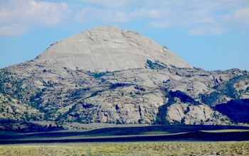
Lankin Dome, one of the research sites, from the south along the Sweetwater River in Wyoming.
Credit and Larger Version
June 2, 2016
Geophysical monitoring of the ground above active supervolcanoes, like the one located in Yellowstone National Park, shows that it rises and falls as magma moves beneath the surface of the Earth.
Magma located under areas that include the Yellowstone region and the western margin of North and South America can erupt violently, spewing vast quantities of ash into the air, followed by slower flows of glassy, viscous magma.
But what do these subterranean magma chambers look like, and where does the magma originate? Modern, active volcanoes cannot answer those questions, scientists say.

Back to the past

Instead, a new study by University of Wyoming researchers suggests scientists can go back to the past to study present-day solidified magma chambers where the erosion has removed overlying rock, exposing granite underpinnings.
The study, funded by the National Science Foundation (NSF), and its findings are outlined in a paper published in the June issue of American Mineralogist, the journal of the Mineralogical Society of America.
"Every geology student is taught that the present is the key to the past," says geologist Carol Frost, director of NSF's Division of Earth Sciences, on leave from the University of Wyoming. "In this study, we used the record from the past to understand what's happening in modern magma chambers."
 
Secrets in a batholith
 
One such large granite body, the 2.62 billion-year-old Wyoming batholith, extends more than 125 miles across central Wyoming.
University of Wyoming earth scientist Davin Bagdonas traversed the Granite, Shirley and Laramie Mountains to examine the batholith. He found remarkable uniformity, with similar minerals throughout.
Says Bagdonas, who worked on the project with Frost, "only minor variations were observed in granite near the roof and margins."
That homogeneity, or sameness, indicates the crystallizing magma was well-mixed. However, more subtle variations across the batholith show that the magma formed by the melting of multiple rock sources that rose through several conduits.
Large bodies composed of biotite granite, such as the Wyoming batholith, are more common in the Neoarchean era (2.8 billion-2.5 billion years ago) than in younger terrains. The reason may relate to higher radioactive heat production in the past, which provided power to drive extensive granite formation.
"If these ancient rocks are analogs for the magma systems underlying modern supervolcanoes, then explosive volcanism may have been far more abundant in Earth's past than it is today," the researchers conclude in their paper.
-- Cheryl Dybas, NSF (703) 292-7734
  cdybas@nsf.gov
-- Chad Baldwin, University of Wyoming (307) 766-3257
 cbaldwin@uwyo.edu
Investigators Carol Frost
B. Ronald Frost
Kevin Chamberlain
Related Institutions/Organizations University of Wyoming
Related Programs Tectonics
Total Grants $225,135
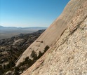
View from below the summit of Lankin Dome, showing granite that caps the peak.
Credit and Larger Version
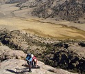
Scientists Carol Frost and Davin Bagdonas prepare for the next pitch up Lankin Dome.
Credit and Larger Version
Carol Frost and Davin Bagdonas making observations near the summit of Lankin Dome.
Credit and Larger Version
Granite of the Wyoming batholith exposed in Wyoming's Granite Mountains.
Credit and Larger Version
The National Science Foundation (NSF)
Guillermo Gonzalo Sánchez Achutegui
ayabaca@gmail.com
ayabaca@hotmail.com
ayabaca@yahoo.com
Inscríbete en el Foro del blog y participa : A Vuelo De Un Quinde - El Foro!

domingo, 24 de marzo de 2013

NASA - First Images Released From Newest Earth Observation Satellite


A Closer Look at LDCM's First Scene
03.21.13
 
Turning on new satellite instruments is like opening new eyes. This week, the Landsat Data Continuity Mission (LDCM) released its first images of Earth, collected at 1:40 p.m. EDT on March 18. The first image shows the meeting of the Great Plains with the Front Ranges of the Rocky Mountains in Wyoming and Colorado. The natural-color image shows the green coniferous forest of the mountains coming down to the dormant brown plains. The cities of Cheyenne, Fort Collins, Loveland, Longmont, Boulder and Denver string out from north to south. Popcorn clouds dot the plains while more complete cloud cover obscures the mountains.
http://www.nasa.gov/images/content/736089main_fortcollins_oli_2013077_1080_labeled.jpg
http://www.nasa.gov/images/content/736092main_fortcollins_oli_2013077_swir_1080_labeled.jpg 
 
http://www.nasa.gov/images/content/736089main_fortcollins_oli_2013077_1080_labeled.jpg  
Click and drag the slider bar to compare these LDCM images, which zoom into the area around Fort Collins, Colo. On the left, the image is shown in natural color, created using data from OLI spectral bands 2 (blue), 3 (green), and 4 (red). The image on the right was created using data from OLI bands 3 (green), 5 (near infrared), and 7 (short wave infrared 2) displayed as blue, green and red, respectively. In the left-hand natural color image, the city's elongated Horsetooth Reservoir, a source of drinking water, lies west of the city. A dark wildfire burn scar from the Galena Fire is visible just to the left of the reservoir. The scar shows up bright, rusty red in the false color image.
Credit: USGS/NASA Earth Observatory
› Download left image | unlabeled version
› Download right image | unlabeled version

LDCM is a joint mission of NASA and the Department of Interior's U.S. Geological Survey.

"It's a really great day," said Jeff Pedelty, an instrument scientist at NASA's Goddard Space Flight Center in Greenbelt, Md., who worked on the LDCM Operational Land Imager, or OLI instrument, that took the natural color image. He's very impressed with the level of detail they can see with the advancements to the sensor. "It's wonderful to see, there's no doubt about it, and it's a relief to know that this is going to work wonderfully in orbit."

The natural color image showed the landscape in the colors our eyes would see, but Landsat sensors also have the ability to see wavelengths of light that our eyes cannot see. LDCM sees eleven bands within the electromagnetic spectrum, the range of wavelengths of light. OLI collects light reflected from Earth's surface in nine of these bands. Wavelengths on the shorter side include the visible blue, green, and red bands. Wavelengths on the longer side include the near infrared and shortwave infrared.

LDCM's second instrument, the Thermal Infrared Sensor (TIRS) detects light emitted from the surface in two even longer wavelengths called the thermal infrared. The intensity of the emitted light at the longer wavelengths measured by TIRS is a function of surface temperature. In the black-and-white image of the first thermal band on TIRS, warmer areas on the surface are brighter while cooler areas are dark.

The first thermal images seen by Dennis Reuter, TIRS instrument scientist at Goddard, were forwarded to him from the data processors. "To say it was exciting was an understatement," said Reuter, who was blown away by the data quality. "Wow! This is beautiful!" he wrote in an email. "Look at those amazing clouds! And the detail!"

Clouds in the colder upper atmosphere stand out as black in stark contrast to a warmer ground surface background. The TIRS images were collected at exactly the same time and place as the OLI data, so all eleven bands can be used together.

diagram illustrating how LDCM observations at different wavelengths are combined to create one image
This diagram illustrates how LDCM's observations at different wavelengths are combined to create one image.
Credit: NASA's Goddard Space Flight Center
› Larger image

The infrared bands on both TIRS and OLI complement the visible bands, said Reuter. "You're seeing things in the visible that you don't necessarily see in the infrared, and vice versa," he said.

Different characteristics on the ground dictate the intensity of the reflection and emission of light in different bands from the surface, ultimately allowing scientists to distinguish between different surface features. To highlight differences across an image, analysts sometimes assign artificial colors to data from different spectral bands for display.

For example, zooming in to the area around Fort Collins, Colo., the natural color image was created from OLI bands 2 (blue), 3 (green), and 4 (red) data. In the image, a dark stripe can be seen just west of the Horsetooth Reservoir, a source of drinking water for the city. The stripe is a scar left in the aftermath of the Galena wildfire. That same burned area bursts out of the image as a bright, rusty red scar with greater contrast between the surrounding areas in the false color image. The false color image was created using data from OLI bands 3 (green), 5 (near infrared), and 7 (short wave infrared 2), assigned the colors blue, green and red respectively. These types of LDCM images and the accompanying data will be used by multi-agency Burned Area Emergency Response teams to plan and carry out wildfire recovery measures.

Similarly, the thermal bands that detect wavelengths dependent on surface temperature show more than just high altitude clouds. This ability to measure differences in temperature across the land surface is essential to one of the major applications of LDCM data: water management. Analysts in western states will use TIRS data in conjunction with OLI data to determine the amount of water being used in irrigated agricultural fields.

black-and-white LDCM scene of Boulder-Fort Collins area in Colorado
This black-and-white Landsat scene shows the area where the Great Plains meet the Front Range of the Rocky Mountains in Wyoming and Colorado. The image was created using data from the first TIRS thermal infrared band. Warmer surfaces appear light gray to white in the thermal image while cooler areas appear dark gray to black. Clouds in the colder upper atmosphere, for instance, appear black against the lighter background of the warmer ground surface. When the satellite begins normal operations, data products will contain co-registered (simultaneous) data for all of the OLI and TIRS.

Note to Landsat data users: This scene is slightly off set from the standard Path 33, Row 32 Landsat scene as LDCM has not yet reached its nominal 438-mile (705-kilometer) operational orbit.

Credit: USGS/NASA Earth Observatory
› Larger image (12 MB tif)

"When you water plants they take it in through their roots and it comes up to their leaves, and if they have a plentiful water supply, they transpire," said Reuter. Transpiration, as well as evaporation from the soil, means that the water goes back into the atmosphere.

"It's just like when we sweat, we cool down. [Plants] cool down when they have a lot of water," said Reuter. "It's a beautiful illustration of the physics of radiative transfer and also the usefulness of the data." This application of LDCM data will be essential to the effective management of scarce water resources in our arid and semi-arid states.

LDCM image of the Fort Collins/Boulder area LDCM captured this image on March 18, 2013, the first day that OLI observed Earth from space. This natural color Landsat scene was created using data from OLI spectral bands 2 (blue), 3 (green) and 4 (red), and it emulates the true colors the human eye would see from space. The data were collected at the same time as the TIRS data in the black-and-white image. Both Reuter and Pedelty were impressed with the level of detail they see in the OLI and TIRS data. Part of that detail comes from the push broom design of both instruments. Instead of instruments that scan back and forth across a swath on the ground, push broom data collection looks across whole swath at once, allowing the sensors to observe each patch of ground longer. "It's like taking a thermometer and letting it sit there longer to get a more stable measurement," said Reuter. But the work is only beginning for validating the data quality and getting ready for normal mission operations. These images were processed using pre-launch settings, which must be checked and adjusted now that LDCM is in orbit to ensure that the data accurately measure the intensity of reflected and emitted light received by the instruments. The mission operations team also needs to ensure that each pixel is accurately located on Earth's surface. Among the first activities planned in the next two months are reference checks for both OLI and TIRS. OLI will look indirectly at the sun with its solar diffuser panel. "We let the sun shine on the panel so it makes a bright uniform target and we image that," said Pedelty, who adds that while it may seem mundane compared to an image of Earth, it's a key reference measurement for updating OLI's calibration. In addition, for both OLI and TIRS calibration, LDCM will view deserts, the ocean and the moon, surfaces with relatively stable and well-known reflectance and emittance properties. The mission operations team also plans to fly underneath the currently orbiting Landsat 7 to collect data at the same time in order to cross-calibrate the two LDCM sensors with the Landsat 7 Enhanced Thematic Mapper-Plus (ETM+) instrument. "Everything has been very exciting," said Reuter. These first images are the culmination of a lot of hard work from the people at NASA and USGS, the Landsat Science Team and their industry partners at Ball Aerospace Corp. in Boulder, Colo., that built OLI, and Orbital Science Corp. of Gilbert, Ariz., that built and tested the spacecraft, he said. "As a tool for science, for looking at the whole planet and seeing how we're affecting it, and how it's affecting us, it's gratifying in all ways." Pedelty agrees. "I was privileged to work onsite at Ball Aerospace as they designed, built and tested the OLI. Then I moved to Orbital Sciences to help test the LDCM observatory. A lot of talented people worked very hard and everything had to work. And it has." LDCM's normal operations are scheduled to begin in late May when the instruments have been calibrated and the spacecraft has been fully checked out. At that time, NASA will hand over control of the satellite to the USGS, which will operate the satellite throughout its planned five-year mission life. The satellite will be renamed Landsat 8, and data from OLI and TIRS will be processed and added to the Landsat Data Archive at the Earth Resources Observation and Science Center in South Dakota, where it will be distributed for free over the Internet.


Note to Landsat data users: This scene is slightly off set from the standard Path 33, Row 32 Landsat scene as LDCM has not yet reached its nominal 438-mile (705-kilometer) operational orbit.


Credit: USGS/NASA Earth Observatory

› Larger image (32 MB jpg)


LDCM image of Boulder, Colo., area
The area around Boulder, Colo., is shown here in a true color image collected by the OLI aboard LDCM on March 18, 2013. The OLI and an important component of TIRS, its cryocooler, were built at the Ball Aerospace & Technologies Corporation facility in Boulder.
Credit: USGS/NASA Earth Observatory
› Download larger image | unlabeled version


Related Links


› NASA press release: "First Images Released from Newest Earth Observation Satellite"
› NASA Earth Observatory: "First View from the New Landsat Satellite"
› NASA's LDCM website
› USGS Landsat website


Ellen Gray
NASA's Earth Science News TeamNASA
Guillermo Gonzalo Sánchez Achutegui
ayabaca@gmail.com
ayabaca@hotmail.com
ayabaca@yahoo.com
Inscríbete en el Foro del blog y participa : A Vuelo De Un Quinde - El Foro!
Mi lista de blogs