Mostrando entradas con la etiqueta Yosemite National Park. Mostrar todas las entradas

domingo, 23 de julio de 2017

The National Science Foundation (NSF) :Researchers discover how wildfires create their own weather .- Los investigadores descubren cómo los incendios forestales crean su propio clima

https://www.nsf.gov/discoveries/disc_summ.jsp?cntn_id=242554&WT.mc_id=USNSF_1


In a season of fast-spreading western U.S. and Canada fires, information is timely
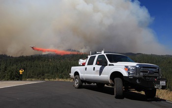
Doppler LiDAR is measuring winds near the plume of the King Fire in California in September, 2014.

Doppler LiDAR is measuring winds near the plume of the King Fire in California in September, 2014.
Credit and Larger Version

July 20, 2017
Find related stories on NSF's geosciences risk and resilience interest area.
Scientists working close to the line of wildfires are obtaining a new understanding of the fires' smoke plumes. The results are providing real-time information, such as vertical wind profiles, to firefighters battling blazes.
Through this National Science Foundation (NSF)-funded research, Craig Clements, a meteorologist at San José State University (SJSU), and researcher Neil Lareau, also of SJSU, have discovered that wildfires can create their own weather, leading to extreme fire behavior.
In a paper recently published in the Journal of Applied Meteorology and Climatology, the scientists report findings from inside wildfire plumes, information previously obtained only from computer simulations.
"This research offers rare observations of the behavior of wildfire smoke plumes," says Nick Anderson, program director in NSF's Division of Atmospheric and Geospace Sciences, which supported the research. "Improved understanding of wildfire plumes is important for determining whether smoke will stay near the ground and affect air quality and visibility, or whether it will rise into the atmosphere and potentially affect clouds and the amount of sunlight reaching the ground."
The SJSU researchers mounted Doppler LiDAR (Light Detection and Ranging, a remote-sensing method that uses light in the form of a pulsed laser to measure distances) instruments onto a pickup truck, which they placed near wildfires. "Until now," says Clements, "it has been difficult to sample wildfires with such sophisticated instruments because of logistical and safety concerns."
The team overcame that by obtaining firefighter credentials, which allowed them access to active wildfires, and by using a nimble, truck-mounted system that could be rapidly deployed. "Our work is providing new information about fire-atmosphere interactions and how wildfires spread," says Clements.
In addition to conducting research at active wildfires in the western U.S., the scientists performed controlled field experiments, setting fires and monitoring their rapid spread through an array of atmospheric instrumentation.
These studies gave the researchers information on how wildfires create their own weather systems. Those weather systems, in turn, fuel extreme fire behavior.
In their journal paper, the scientists present observations from the El Portal Fire of July, 2014, in Yosemite National Park, California.
The results revealed vigorous, fire-generated updrafts, says Clements, and strongly turbulent eddies that formed along the fire plume's edges. The data also showed that fire-modified winds extended more than one mile from the fire itself.
The findings confirm longstanding, but previously unvalidated, predictions for how plumes rise from fires, and offer new insights into the processes that control how high and how far wildfire smoke will spread. a vuelo
In addition to the El Portal Fire, the team has studied 22 other large wildfires in the western U.S.
"We're seeing a large number of fires," says Clements. "Many are extreme in terms of intensity. Higher-intensity fires cause deeper plumes, which can help spread fires by lofting embers and causing spot fires.
"That situation is dangerous for both firefighters and communities that are in the paths of fires -- like those in British Columbia and California this summer. We need more sophisticated models to better predict fire behavior, especially in a changing climate."
-- Cheryl Dybas, NSF (703) 292-7734
  cdybas@nsf.gov
-- Robin McElhatton, SJSU (408) 924-1749
  robin.mcelhatton@sjsu.edu

Investigators Craig Clements
Related Institutions/Organizations San Jose State University Foundation
Total Grants $900,337
An experimental grass fire spreads under a meteorological tower.
Credit and Larger Version
The experimental grass fire spreads through instrumentation placed in a research plot.
Credit and Larger Version
Researchers watch the El Portal Fire plume's evolution in Yosemite National Park in July, 2014.
Credit and Larger Version
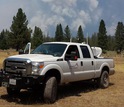
The plume of California's Bald Fire is sampled with mobile Doppler LiDAR in August, 2014.
Credit and Larger Version
Scientists use a mobile atmospheric profiling system near the Eiler Fire in Calif. in July, 2014.
Credit and Larger Version
National Science Foundation (NSF)
Guillermo Gonzalo Sánchez Achutegui
ayabaca@gmail.com
ayabaca@hotmail.com
ayabaca@yahoo.com
Inscríbete en el Foro del blog y participa : A Vuelo De Un Quinde - El Foro!

lunes, 10 de septiembre de 2012

Science: Study Ties Forest "Greenness" in Western U.S. to Snowpack Extent

Hi My Friends: A VUELO DE UN QUINDE EL BLOG., Results of a new study tie forest "greenness" in the western United States to fluctuating year-to-year snowpack extent.
Mid-elevation mountain ecosystems most sensitive to rising temperatures and changes in snowmelt
 A Sierra Nevada forest in Sequoia National Park: snow depth and forest pattern are related.
Credit: University of Colorado, Boulder
 Taking snow depth measurements in Sequoia National Park requires snowshoes.
Credit: University of Colorado, Boulder
 Forests influence snow distribution. Snowmelt in turn affects forest productivity.
 
Credit: University of Colorado, Boulder

 A snow depth sensor in Yosemite National Park provides information about the snowpack.
Credit: University of Colorado, Boulder
 Scientist Noah Molotch samples snow density in a snow pit used to estimate water content.
Credit: University of Colorado, Boulder
 Noah Molotch, Danielle Perot and Ty Atkins study snow properties from inside a snow pit.
Credit: University of Colorado, Boulder

Results of a new study tie forest "greenness" in the western United States to fluctuating year-to-year snowpack extent.
The results show that mid-elevation mountain ecosystems are the most sensitive to rising temperatures and to changes in precipitation and snowmelt.
University of Colorado-Boulder scientist Noah Molotch and colleagues used satellite images and ground measurements to identify the threshold at which mid-level forests sustained by moisture change to higher-elevation forests sustained by sunlight.
A paper reporting the results was published yesterday in the journal Nature Geoscience.
Molotch is the lead author. Co-authors are Ernesto Trujillo of the University of Colorado-Boulder and Ecole Polytechnique Fédérale de Lausanne in Switzerland; Michael Golden and Anne Kelly of the University of California, Irvine; and Roger Bales of the University of California, Merced.
"The research demonstrates yet another complexity in the response of mountain ecosystems to increasing temperatures," says hydrologist Tom Torgersen, program director in the National Science Foundation's Division of Earth Sciences, which funded the research. "High-elevation mountain forests are typically temperature-stressed and low-elevation mountain forests are often water-stressed.
"At mid-elevations, 'everything is just right'--until it goes wrong." Torgersen says, "Higher temperatures lead to reduced snowpack and reduced water availability, leaving trees at mid-elevations more stressed and more prone to fires."
The ability to identify this "tipping point" is important, Molotch says, because mid-level forests--at altitudes from roughly 6,500 feet to 8,000 feet--are where many people live and visit. They're also linked with increasing wildfires, beetle outbreaks and rising tree mortality.
"These results provide the first direct observations of snowpack-forest connections across broad scales," says Molotch.
"Finding the tipping point between water-limited [mid-elevation] forests and energy-limited [high-elevation] forests defines the region of the greatest sensitivity to climate change--the mid-elevation forests--which is where we should focus future research," he says.
Although the research took place in the Sierra Nevada mountain range in California, it's applicable to other mountain ranges across the West.
Climate studies show that the snowpack in mid-elevation forests in the western United States and other forests around the world has been decreasing over the past 50 years because of regional warming.
"We found that mid-elevation forests show a dramatic sensitivity to snow that fell the previous winter in terms of accumulation and subsequent melt," said Molotch, also a scientist at NASA's Jet Propulsion Laboratory in Pasadena.
"If snowpack declines, forests become more stressed, which can lead to ecological changes in the distribution and abundance of plant and animal species, and to more vulnerability to fires and to beetle kill."
Molotch says that about 50 percent of the greenness seen by satellites in mid-elevation forests is linked with maximum snow accumulation from the previous winter, with the other 50 percent related to soil depth, soil nutrients, temperature and sunlight.
"The strength of the relationship between forest greenness and snowpack from the previous year is very surprising," Molotch says.
The researchers initially set out to identify the various components of drought that lead to vegetation stress.
"We went after mountain snowpacks in the western U.S. because they provide about 60 to 80 percent of the water in high-elevation mountains," says Molotch.
The team used 26 years of continuous data from the Advanced Very High Resolution Radiometer, a space-borne sensor flying on a National Oceanic and Atmospheric Administration satellite, to measure the forest greenness.
The researchers compared it with long-term data from 117 snow stations maintained by the California Cooperative Snow Survey, a consortium of state and federal agencies.
In addition, the scientists used information gathered from "flux towers" in the southern Sierra Nevada mountain range. Instruments on these towers measure the exchanges of carbon dioxide, water vapor and energy between the land and the atmosphere.
Instruments on the towers, which are some 100 feet high, allowed scientists to measure the sensitivity of both mid-level and high-level mountainous regions to both wet and dry years--data that matched up well with the satellite and ground data.
"The implications of this study are profound when you think about the potential for ecological change in mountain environments in the West," says Molotch.
"If we look ahead to the time when climate models are calling for warming and drying conditions, the implication is that forests will be increasingly water-stressed in the future and more vulnerable to fires and insect outbreaks."
In the context of recent forest losses to fire in Colorado and elsewhere, the findings are something that really deserve attention, Molotch says.
"This tipping-point elevation is very likely going to migrate up the mountainsides as climate warms."
The research was also funded by NASA.
-NSF-

Media Contacts Cheryl Dybas, NSF (703) 292-7734 cdybas@nsf.gov
Jim Scott, University of Colorado-Boulder (303) 492-3114 jim.scott@colorado.edu
Related WebsitesNSF discovery article: A Tree Stands in the Sierra Nevada: http://www.nsf.gov/discoveries/disc_summ.jsp?cntn_id=125091&org=NSF
NSF Southern Sierra Critical Zone Observatory: https://eng.ucmerced.edu/czo/index.html
NSF Critical Zone Observatories: Where Rock Meets Life: http://www.criticalzone.org/
The National Science Foundation (NSF) is an independent federal agency that supports fundamental research and education across all fields of science and engineering. In fiscal year (FY) 2012, its budget is $7.0 billion. NSF funds reach all 50 states through grants to nearly 2,000 colleges, universities and other institutions. Each year, NSF receives over 50,000 competitive requests for funding, and makes about 11,000 new funding awards. NSF also awards nearly $420 million in professional and service contracts yearly.
Useful NSF Web Sites:
NSF Home Page: http://www.nsf.gov
NSF News: http://www.nsf.gov/news/
For the News Media: http://www.nsf.gov/news/newsroom.jsp
Science and Engineering Statistics: http://www.nsf.gov/statistics/
Awards Searches: http://www.nsf.gov/awardsearch/
 The National Science Foundation (NSF)
Guillermo Gonzalo Sánchez Achutegui
ayabaca@hotmail.com
ayabaca@gmail.com
ayabaca@yahoo.com 
 Inscríbete en el Foro del blog y participa : A Vuelo De Un Quinde - El Foro!

Mi lista de blogs