Hi My Friends: A VUELO DE UN QUINDE EL BLOG., We have received information of the scientific of the National Science Foundation(NSF) about the origin of the forest fires, which happened in New Mexico's Jemez River Basin on June 26, 2011, at 1 p.m. local time......
They said........."The following is part seven in a series on the National Science Foundation's Critical Zone Observatories (CZO) Network. Visit part one, part two, part three, part four, part five and part six.
If a tree falls in a forest and no one is around to hear it, does it make a sound?
The answer is yes, if it happened in New Mexico's Jemez River Basin on June 26, 2011, at 1 p.m. local time.
The
tipping of one tree as it creaked and fell hinted at a crackle soon to
come, a fast-burning wildfire. Ultimately, the fire blazed through a
large part of a 1.5 million-acre national forest...."
Also they said......."To find out, scientists at the National Science Foundation (NSF)
Jemez River Basin and Santa Catalina Mountains Critical Zone Observatory
(CZO), one of six such NSF CZOs in watersheds across the country, lit
out for the hills.
The Jemez River Basin and Santa Catalina
Mountains CZO is formed by twin sites: one in the Jemez River Basin in
the Valles Caldera National Preserve north of Albuquerque, N.M., in the
greater Rio Grande Basin; the other in the Santa Catalina Mountains
northeast of Tucson, Ariz., in the Colorado River Basin....."
I invite them to read the original version in its entirety............
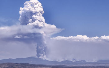
New Mexico's 2011 Las Conchas Fire as it races down the flanks of the Jemez Mountains.
Credit: Wikimedia Commons
Download the high-resolution JPG version of the image. (247 KB)
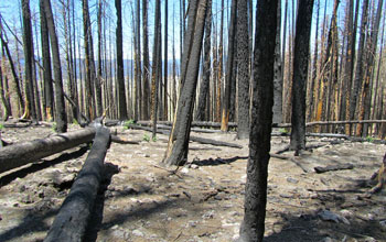
Ghosts of the forest stand guard over NSF's Jemez River Basin Critical Zone Observatory and the Valles Caldera National Preserve.
Credit: Valles Caldera National Preserve
Download the high-resolution JPG version of the image. (690 KB)
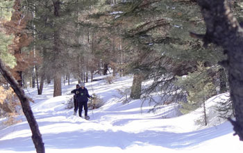
On Rabbit Mountain, N.M., scientists survey slopes with unburned healthy forests.
Credit: Paul Brooks
Download the high-resolution JPG version of the image. (157 KB)
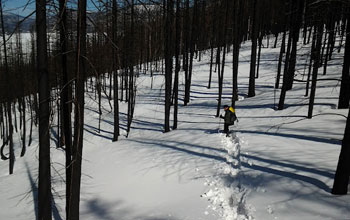
A comparison survey of Rabbit Mountain's badly burned forests.
Credit: Paul Brooks
Download the high-resolution JPG version of the image. (102 KB)
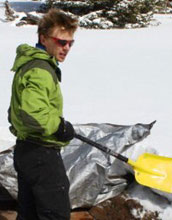
Scientist Adrian Harpold digs out an instrument used to measure snowmelt chemistry.
Credit: Allison Peterson
Download the high-resolution JPG version of the image. (27 KB)
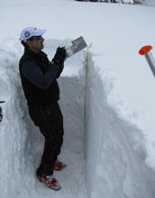
Paul Brooks collects samples for snow density, chemistry, and physical structure.
Credit: Brian Chaszar
Download the high-resolution JPG version of the image. (1 MB)
The following is part seven in a series on the National Science Foundation's Critical Zone Observatories (CZO) Network. Visit part one, part two, part three, part four, part five and part six.
If a tree falls in a forest and no one is around to hear it, does it make a sound?
The answer is yes, if it happened in New Mexico's Jemez River Basin on June 26, 2011, at 1 p.m. local time.
The
tipping of one tree as it creaked and fell hinted at a crackle soon to
come, a fast-burning wildfire. Ultimately, the fire blazed through a
large part of a 1.5 million-acre national forest.
On the day the
fire started, strong, unpredictable winds blew through the trees,
rustling leaves and creaking dead wood. Perhaps in a gust, a lone tree
fell. On the way down, it took out a power line and sparked a fire
that--by high noon the next day--had burned 43,000 acres, an acre every
two seconds.
At sundown that next day, the Las Conchas Fire, as it
came to be called, still ran wild. The toll had climbed to more than
61,000 acres of forest. Egged on by north winds, it jumped the trails
of Pajarito Mountain Ski Area. Then it turned and raged south,
threatening the town of Cochiti, N.M.
Within four days, it had singed more than 103,000 acres, making it the largest fire in New Mexico history at the time.
The forest and the watershed--the critical zone--left behind
What happened to the forests, rivers and streams the Las Conchas Fire left behind?
To
find out, scientists at the National Science Foundation (NSF) Jemez
River Basin and Santa Catalina Mountains Critical Zone Observatory
(CZO), one of six such NSF CZOs in watersheds across the country, lit
out for the hills.
The Jemez River Basin and Santa Catalina
Mountains CZO is formed by twin sites: one in the Jemez River Basin in
the Valles Caldera National Preserve north of Albuquerque, N.M., in the
greater Rio Grande Basin; the other in the Santa Catalina Mountains
northeast of Tucson, Ariz., in the Colorado River Basin.
In
addition to the Jemez River Basin and Santa Catalina Mountains site in
New Mexico and Arizona, NSF CZOs are located in the Southern Sierra
Nevada, Christina River Basin on the border of Delaware and
Pennsylvania, Susquehanna Shale Hills in Pennsylvania, Boulder Creek in
the Colorado Rockies, and Luquillo National Forest in Puerto Rico.
CZO
scientists provide a new understanding of the critical zone--the thin
veneer of Earth that extends from the top of the forest canopy to the
base of weathered bedrock.
At the Jemez River and Santa Catalina
Mountains CZO, researchers are asking questions such as: How does
climate variation affect arid and semi-arid ecosystems? And, how do
feedbacks between critical zone structure and the cycling of water and
carbon alter short-term hydrology and long-term landscape evolution?
The
water cycle, the breakdown of rocks and the eventual formation of soil,
the evolution of rivers and valleys, the patterns of plant growth and
landforms, all result from processes that take place in the critical
zone.
"The critical zone is our living environment," says
Enriqueta Barrera, program director in NSF's Division of Earth Sciences,
which funds the CZO network. "The CZOs offer us new knowledge about
this important zone and its response to climate and land-use change."
The
CZOs are the first systems-based observatories dedicated to
understanding how Earth's surface processes are coupled, she says. "They
will help us predict how the critical zone affects the ecosystem
services on which society depends."
Fire burns long after it's out
Water is at the top of that list of ecosystem services.
The freshwater supplies of the American West rely, for the most part, on snow.
As
snow melts into water, it begins a journey that starts in the mountains
and ends in faucets. When people turn on the shower or the sprinkler,
they're watering themselves, lawns and food crops with melted snow.
The
Colorado River, the Rio Grande and other rivers in the intermountain
west are the main sources of water for some of the driest parts of the
country, say Jemez River Basin and Santa Catalina Mountains CZO
scientists Jon Chorover and Paul Brooks of the University of Arizona and
Adrian Harpold of the University of Colorado.
"Their flows are predominantly fed by snowmelt from high-elevation forests and meadows," says Brooks.
Snow-covered
forests are "a critical source of water in the western U.S.," agrees
Chorover. "Forests' ability to 'hold snow' can be affected by fires,
tree diseases, insect-caused die-offs and other factors."
The Las
Conchas Fire provided a unique opportunity to "evaluate how forest fires
interact with a changing climate," says Harpold, first author of a
recent paper on the fire's effects on winter snow and spring snowmelt
published in the journal Ecohydrology. Brooks and other scientists are co-authors.
"Forest
fires have been increasing in size and severity for the last several
decades," Harpold says. "Drier and warmer than average conditions in
New Mexico in 2011 contributed to fires like Las Conchas.
"When
the fire removed the forest canopy, more water vapor was lost from the
snow surface to the dry atmosphere, reducing the amount of water stored
in the snowpack and released the following spring."
In essence, the scientists found, areas not burned in the fire retained more snow--and snowmelt water.
Into the Valles Caldera
The
Valles Caldera National Preserve, it's called, a parkland that
surrounds the Valles Caldera, a 13.7 mile wide volcanic caldera in the
Jemez Mountains of northern New Mexico. The preserve overlaps the Jemez
River Basin CZO.
Valles Caldera National Preserve was the site of
the scientists' study; their research was conducted on Rabbit Mountain
near the park's southern boundary.
In November 2011, the
researchers placed instruments in several catchments, or river basins,
on Rabbit Mountain. The resulting information is being used to better
understand the effects of fire on the water, carbon and energy cycles of
the entire Jemez River Basin.
"The Jemez River Basin CZO is perfectly situated to learning how fire affects water resources," says Brooks.
In
the winter and spring of 2012, Brooks and Harpold, along with other
researchers and students, collected and analyzed thousands of data
points on snow depth and density in burned and unburned forests on
Rabbit Mountain.
"We obtained one of the most complete data sets to date on snow hydrology and fire," says Brooks.
Spruce-fir forests dominate Rabbit Mountain's heights; ponderosa pines and oak scrublands cover the lower mountain.
Whether
in spruce-fir or pine-oak, the Las Conchas Fire left much of Rabbit
Mountain with severe burns. Dead, limbless trees, ghosts of the forest,
line the horizon.
In unburned forests, about one-third of the
fresh snow that fell in the winter of 2012 was caught in trees before it
reached the ground. There shade and wind protection allowed it to
accumulate over the winter.
Where trees were lost to the fire,
more fresh snowfall made it to the ground. In the end, however, that
was a double-edged sword: lack of shelter from the forest canopy
resulted in more of the snowpack disappearing over the winter.
"Such
changes in snowpack depth have important ramifications," says Chorover,
"for ecological health and for downstream water resources."
After the Las Conchas Fire, if a tree falls in the forest and no one is around to hear it, does it make a sound?
If
you're listening for burbling spring brooks or streaming kitchen
faucets, you may hear nothing but drip, drip, drip. Or silence.
| -- | Cheryl Dybas, NSF (703) 292-7734 | cdybas@nsf.gov |
Related Websites
NSF Critical Zone Observatory Network:
NSF Critical Zone Observatory Network:
http://criticalzone.org/national/
NSF Jemez River Basin and Santa Catalina Mountains CZO:
NSF Jemez River Basin and Santa Catalina Mountains CZO:
http://criticalzone.org/jemez-catalina/
NSF News Release: How Is Earth's Water System Linked With Land Use, Climate Change and Ecosystems?:
NSF News Release: How Is Earth's Water System Linked With Land Use, Climate Change and Ecosystems?:
http://www.nsf.gov/news/news_summ.jsp?cntn_id=125434&org=NSF&from=news
NSF Publication: Discoveries in Sustainability:
NSF Publication: Discoveries in Sustainability:
The National Science Foundation (NSF)
Guillermo Gonzalo Sánchez Achutegui
ayabaca@gmail.com
ayabaca@hotmail.com
ayabaca@yahoo.com
Inscríbete en el Foro del blog y participa : A Vuelo De Un Quinde - El Foro!

No hay comentarios:
Publicar un comentario