Anvil-shaped promontory formed inside an ancient supervolcano
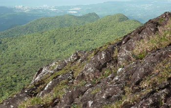
The peak El Yunque presides over the island of Puerto Rico.
Credit: Gilles Brocard
Download the high-resolution JPG version of the image. (183 KB)
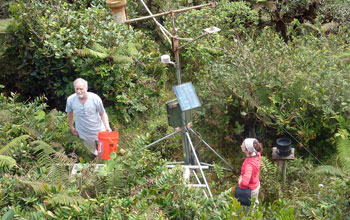
Scientist Fred Scatena (left) and colleagues near a weather station on East Peak.
Credit: Gilles Brocard
Download the high-resolution JPG version of the image. (1.7 MB)
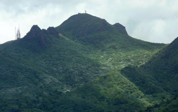
El Yunque and East Peak from below. The U.S. Navy once had a facility on East Peak.
Credit: Gilles Brocard
Download the high-resolution JPG version of the image. (1 MB)
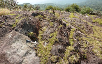
Geoscientists are studying erosion on El Yunque--a hard-headed "cap" on the island.
Credit: Gilles Brocard
Download the high-resolution JPG version of the image. (220 KB)
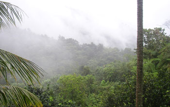
Morning mist hides the rocky face of El Yunque.
Credit: Wikimedia Commons
Download the high-resolution JPG version of the image. (1.2 MB)
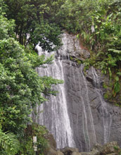
Waterfalls cascade down El Yunque's steep sides.
Credit: Wikimedia Commons
Download the high-resolution JPG version of the image. (1.4 MB)
The following is part five in a series on the National Science Foundation's Critical Zone Observatories (CZOs). Part one describes the work of the Susquehanna Shale Hills CZO. Part two focuses on the Southern Sierra CZO. Part three highlights research at the Christina River Basin CZO. Part four features the Boulder Creek CZO.
El Yunque. It could be the name of an ancient chieftain. On the island of Puerto Rico, in a sense it is.
El
Yunque, Spanish for "the anvil," is a majestic, flat-topped promontory.
It stands high above rivers and streams below, and has been an icon
since pre-Columbian times.
With Puerto Rico's humid tropical
climate, El Yunque should be covered with plant life--and should be
eroding rapidly, say scientists. But it isn't.
To solve this
mystery, researchers from the National Science Foundation's (NSF)
Luquillo Critical Zone Observatory (CZO) set out to measure the current
rate of the rock's erosion.
El Yunque is usually shrouded by mist
from clouds. Swept by the trade winds, it's often buffeted by
hurricanes. The barren rock, some 3,412 feet tall, lords it over miles
of rainforest that surround it on all sides.
It's showered with
rain an average of three times a day--in total, more than 14 feet of
rain every year. That rain cascades down El Yunque's headland, then
flows through the Luquillo watershed in rivers and rivulets.
The
Luquillo CZO is one of six NSF CZOs in watersheds across the nation. In
addition to the Luquillo site, CZOs are located in the Southern Sierra
Nevada, Christina River Basin on the border of Delaware and
Pennsylvania, Susquehanna Shale Hills in Pennsylvania, Boulder Creek in
the Colorado Rockies, and the Jemez River and Santa Catalina Mountains
in New Mexico and Arizona.
NSF-supported scientists are providing a
new understanding of the critical zone--the thin veneer of Earth that
extends from the top of the forest canopy to the base of weathered
bedrock.
The water cycle, the breakdown of rocks and the eventual
formation of soil, the evolution of rivers and valleys, the patterns of
plant growth and landforms, all result from processes that take place
in the critical zone.
"The critical zone is our living
environment," says Enriqueta Barrera, program director in NSF's Division
of Earth Sciences, which funds the CZO network. "The CZOs offer us new
knowledge about this important zone and its response to climate and
land-use change."
The CZOs are the first systems-based
observatories dedicated to understanding how Earth's surface processes
are coupled, she says. "They will help us predict how the critical zone
affects the ecosystem services on which society depends."
Peak of endurance
To
find an answer to El Yunque's slow erosion rate, scientists Jane
Willenbring, Gilles Brocard and the late Frederick Scatena of the
University of Pennsylvania used a new approach to calculate how it has
changed over time.
The method involved counting isotopes, or
variants, of chemical elements that accumulate in rocks when they're hit
by cosmic rays from space.
Using these particular isotopes,
called cosmogenic nuclides, the researchers confirmed that forest soils
that aren't disturbed by human activity erode at rates of 250 to 500
feet per million years.
Undisturbed forested areas in Puerto Rico,
for example, have eroded some 1.6 to 3.2 inches since Europeans first
landed there in 1498.
The scientists also found that the presence
of forests can greatly reduce erosion, even in a steep environment
frequently visited by hurricanes.
An ecological view from El Yunque
The
Luquillo critical zone is chemically weathering at a wide range of
rates. "But its thick weave of matted roots and vegetation holds in the
soil and stabilizes the hillslopes such that they erode more slowly than
one would expect," says Willenbring.
On the other hand, Puerto
Rico waterfalls such as the well-known La Coca Falls are eroding
comparatively quickly. Water rushes in torrents through steep canyons
and gullies there, carrying gravel and boulders with it.
"A wave
of erosion--whether fast or slow--affects all parts of the critical
zone," says Willenbring. "It sets the tempo for how quickly minerals and
nutrients are ferried to the surface, which in turn feed the forest
above.
"We were surprised by how connected the landscape is. It seems as though even the trees understand geomorphology."
How
passive are soil microbes and trees? Do they position themselves where
it's best to live, or do they actively change the environment they're
already in?
Glimpse of El Yunque's past...and future?
To
answer these questions as they apply to El Yunque, cosmogenic nuclides
allowed researchers to make the first measurements of the erosion rate
of the peak.
El Yunque's surface is eroding about 13 feet every
million years; it has lost only 0.08 inches since the Europeans first
arrived.
Its relatively slow rate of erosion explains why El Yunque juts above the forest.
"The
texture and composition of the rocks that form El Yunque are more
erosion-resistant than those of the surrounding landscape," says
Willenbring.
Why? El Yunque is a remnant of an ancient
supervolcano named Hato Puerco. The volcano was one of the region's
largest and most active volcanoes during the Cretaceous period 145-66
million years ago.
"El Yunque's hardness and chemical properties
came from being 'cooked' in the chamber of the volcano," says
Willenbring. Other rocks weren't subjected to this same heating; they're
"softer" and less resistant to chemical breakdown and erosion.
Puerto
Rico's icon is a hard-headed cap atop the island, Willenbring says, one
that escaped the geologic fate of all other rocks there.
This article is dedicated to the memory of the late Fred Scatena, former principal investigator of the Luquillo CZO.
| -- | Cheryl Dybas, NSF (703) 292-7734 cdybas@nsf.gov |
Related Websites
NSF Luquillo Critical Zone Observatory: http://criticalzone.org/luquillo/
NSF Critical Zone Observatory Network: http://criticalzone.org/national/
NSF Luquillo Long-Term Ecological Research Site: http://luq.lternet.edu/
The National Science Foundation (NSF)NSF Luquillo Critical Zone Observatory: http://criticalzone.org/luquillo/
NSF Critical Zone Observatory Network: http://criticalzone.org/national/
NSF Luquillo Long-Term Ecological Research Site: http://luq.lternet.edu/
Guillermo Gonzalo Sánchez Achutegui
ayabaca@hotmail.com
ayabaca@gmail.com
ayabaca@yahoo.com
Inscríbete en el Foro del blog y participa : A Vuelo De Un Quinde - El Foro!

No hay comentarios:
Publicar un comentario