Hidden magma layer could play role in shaping the geologic face of our planet.-

Marine scientists haul in a successfully recovered marine electromagnetic receiver.
Credit: Kerry Key
Download the high-resolution JPG version of the image. (465 KB)

Map of the survey region where the research was conducted.
Credit: Scripps Institution of Oceanography
Download the high-resolution JPG version of the image. (499 KB)

Crew deploying an ocean bottom electromagnetic receiver in the ocean off Nicaragua's shores.
Credit: Kerry Key
Download the high-resolution JPG version of the image. (2 MB)
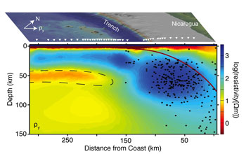
Orange-colored area enclosed by dashed line denotes recently discovered magma layer.
Credit: Scripps Institution of Oceanography
Download the high-resolution JPG version of the image. (149 KB)

Researchers pull an ocean bottom electromagnetic receiver onto the vessel Melville's deck.
Credit: Kerry Key
Download the high-resolution JPG version of the image. (533 KB)
Scientists have discovered a layer of liquified molten rock in
Earth's mantle that may be responsible for the sliding motions of the
planet's massive tectonic plates.
The finding may carry
far-reaching implications, from understanding basic geologic functions
of the planet to new insights into volcanism and earthquakes.
The research was funded by the National Science Foundation (NSF), and is reported in this week's issue of the journal Nature
by Samer Naif, Kerry Key, and Steven Constable of the Scripps
Institution of Oceanography (SIO), and Rob Evans of the Woods Hole
Oceanographic Institution.
"This new image greatly enhances our
understanding of the role that fluids, both seawater and deep subsurface
melts, play in controlling tectonic and volcanic processes," said Bil
Haq, program director in NSF's Division of Ocean Sciences, which funded
the work through the NSF Directorate for Geosciences' MARGINS (now
GeoPRISMS) Program.
The scientists discovered the magma layer at the Middle America trench off Nicaragua's shores.
Using
advanced seafloor electromagnetic imaging technology pioneered at SIO,
the scientists imaged a 25-kilometer- (15.5-mile-) thick layer of
partially melted mantle rock below the edge of the Cocos plate where it
moves beneath Central America.
The new images of magma were captured during a 2010 expedition aboard the research vessel Melville.
After
deploying a vast array of seafloor instruments that recorded natural
electromagnetic signals to map features of the crust and mantle, the
scientists realized they had found magma in a surprising place.
"This
was completely unexpected," said Key. "We went out looking to get an
idea of how fluids are interacting with plate subduction, but we
discovered a melt layer we weren't expecting to find."
For decades scientists have debated the forces that allow the planet's tectonic plates to slide across the Earth's mantle.
Studies
have shown that dissolved water in mantle minerals results in a more
ductile mantle that would facilitate tectonic plate motions, but for
many years clear images and data required to confirm or deny this idea
were lacking.
"Our data tell us that water can't accommodate the
features we are seeing," said Naif. "The information from the new
images confirms the idea that there needs to be some amount of melt in
the upper mantle. That's what's creating this ductile behavior for
plates to slide."
The marine electromagnetic technology employed
in the study was originated by Charles "Chip" Cox, an emeritus
oceanographer at SIO, and in recent years further advanced by Constable
and Key.
They have been working with the energy industry to apply this technology to map offshore oil and gas reservoirs.
The
researchers say their results will help geologists better understand
the structure of the tectonic plate boundary and how that affects
earthquakes and volcanism.
"One of the longer-term implications of
our results is that we are going to understand more about the plate
boundary, which could lead to a better understanding of earthquakes,"
said Key.
The researchers are now trying to find the source that supplies the magma in the newly discovered layer.
The Seafloor Electromagnetic Methods Consortium at SIO also supported the research.
-NSF-
Media Contacts
Cheryl Dybas, NSF (703) 292-7734 cdybas@nsf.gov
Mario Aguilera, SIO (858) 534-3624 maguilera@ucsd.edu
Mario Aguilera, SIO (858) 534-3624 maguilera@ucsd.edu
Related WebsitesNSF MARGINS (now GeoPRISMS) Program: http://www.nsf-margins.org/
NSF GeoPRISMS Program: http://www.geoprisms.org/
NSF GeoPRISMS Program: http://www.geoprisms.org/
The National Science Foundation (NSF) is an independent federal
agency that supports fundamental research and education across all
fields of science and engineering. In fiscal year (FY) 2012, its budget
is $7.0 billion. NSF funds reach all 50 states through grants to nearly
2,000 colleges, universities and other institutions. Each year, NSF
receives over 50,000 competitive requests for funding, and makes about
11,000 new funding awards. NSF also awards nearly $420 million in
professional and service contracts yearly.
Useful NSF Web Sites:
NSF Home Page: http://www.nsf.gov
NSF News: http://www.nsf.gov/news/
For the News Media: http://www.nsf.gov/news/newsroom.jsp
Science and Engineering Statistics: http://www.nsf.gov/statistics/
Awards Searches: http://www.nsf.gov/awardsearch/
The National Science Foundation (NSF)NSF Home Page: http://www.nsf.gov
NSF News: http://www.nsf.gov/news/
For the News Media: http://www.nsf.gov/news/newsroom.jsp
Science and Engineering Statistics: http://www.nsf.gov/statistics/
Awards Searches: http://www.nsf.gov/awardsearch/
Guillermo Gonzalo Sánchez Achutegui
ayabaca@gmail.com
ayabaca@hotmail.com
ayabaca@yahoo.com
Inscríbete en el Foro del blog y participa : A Vuelo De Un Quinde - El Foro!

No hay comentarios:
Publicar un comentario