Hola amigos: A VUELO DE UN QUINDE EL BLOG., la Agencia Espacial Europea - ESA, nos muestra esta espectacular vista desde el espacio del Monte Pinatubo, un temible volcán ubicado en la Isla Luzón de las Filipinas; que erupcionó en el 15 s junio de 1,991, y produjo tantas partículas contaminantes en la atmósfera como lo fue el Krakatoa en 1,883, La atmósfera alrededor de La Tierra se llenó de ácido sulfúrico que produjo un calentamiento de hasta de 0.5 Co.
Los invito a leer la información en inglés....
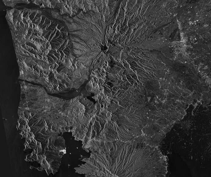
Details
- Title Mount Pinatubo, Philippines
- Released 04/07/2014 10:05 am
- Copyright ESA
- Description This image from the Sentinel-1A radar satellite on 6 June shows part of the Philippine island of Luzon with Mount Pinatubo.This active volcano experienced a major eruption on 15 June 1991 that injected more particulate matter into the atmosphere than any eruption since Krakatoa in 1883. In the months following, aerosols formed a layer of sulphuric acid haze around the globe, ozone depletion increased and global temperatures dropped by about 0.5°C.In the upper-central part of the image, the dark area is Lake Pinatubo, which formed in the summit crater after the 1991 eruption. The water level has been rapidly increasing since its formation, putting pressure on the crater walls, which threaten to collapse and cause flash floods. The Philippine government has taken measures to alleviate the pressure with controlled draining.South of Lake Pinatubo near the centre of the image is Mapanuepe Lake, which also formed as a result of the 1991 eruption. When mud mixed with water and volcanic rock fragments flowed down from Pinatubo, it blocked the drainage of the river. The valley – including the settlements – was inundated. These mud and volcanic debris flows are still visible reaching west towards the South China Sea.Other features visible in this image include the bright radar reflections from a shipyard on the Subic Bay to the south, and the vast expanse of aquaculture on the edge of Manila Bay in the lower-right corner.Sentinel-1A was launched on 3 April, and is the first in a fleet of Sentinel satellites developed for Europe’s Copernicus environment monitoring programme. Although the satellite is still being commissioned, images like this early example illustrate the kind of data the mission will provide.This image is featured on the Earth from Space video programme.
- Id 313471
Guillermo Gonzalo Sánchez Achutegui
ayabaca@gmail.com
ayabaca@yahoo.com
ayabaca@Hotmail.com
Inscríbete en el Foro del blog y participa : A Vuelo De Un Quinde - El Foro!

No hay comentarios:
Publicar un comentario