Results are applicable to metropolitan areas across the country, around the world
 Credit and Larger Version |
July 15, 2014
It's July, a hot time in the city of Denver and in urban areas across the United States.
Summertime is also ozone time, a period when ozone pollution peaks. As global temperatures rise with climate change, summertime ozone--an invisible but harmful pollutant--will become more difficult to keep in check, scientists have found.
By 2050, heavily polluted locations in parts of the East, Midwest and West Coast, where ozone already frequently exceeds federally recommended levels, could face unhealthy summer air in most years.
How and where does summertime ozone begin?
Tracking the origins of summertime ozone
This month, scientists at the National Center for Atmospheric Research (NCAR), University of Colorado Boulder and other organizations are launching a field project across the northern Front Range of Colorado to track the origins of summertime ozone.
The researchers will use specially-equipped aircraft, mobile radars, balloon-mounted sensors and sophisticated computer simulations to measure local and far-flung air pollution sources.
Results from the study will provide needed information to officials working to ensure that air in the region is healthy to breathe.
Reasons summertime ozone pollution on the northern Front Range often exceeds standards include:
- Man-made emissions from human activities such as transportation, energy generation, oil and gas activities and agriculture;
- Natural emissions from vegetation and wildfires;
- Long-range transport of pollution from other western states or cross-continental transport from Asia;
- Downward transport of air from the stratosphere.
The scientists will investigate how these sources, along with unique meteorology and air flow patterns in the region, contribute to ground level ozone.
Ground-level ozone isn't directly emitted. It's formed by the reaction of hydrocarbons and carbon monoxide in the presence of nitrogen oxides and sunlight: ozone precursors.
"Our goal is to produce an accurate and detailed view of all the diverse sources of ozone pollution along the Front Range," says NCAR scientist Gabriele Pfister, a lead scientist on the project.
"We want to fingerprint where the pollution comes from and analyze what happens when it mixes in the atmosphere."
Ozone: From human activities, natural sources
Known as the Front Range Air Pollution and Photochemistry Experiment (FRAPPÉ), the study will focus on the urban corridor from south of Denver north to Fort Collins as well as the adjacent plains and mountains.
Scientists also want to determine how much pollution comes from upwind areas, including other states and countries.
Funded through a federal-state partnership, FRAPPÉ is supported by the Colorado Department of Public Health and Environment and the National Science Foundation (NSF), NCAR's sponsor.
"FRAPPÉ will provide a detailed look at the sources of pollution that affect the air quality of the Colorado Front Range and the health of both people and ecosystems," says Linnea Avallone, a program director in NSF's Division of Atmospheric and Geospace Sciences.
"The data gathered will be used to better understand the unique combination of chemistry and meteorology that leads to poor air quality and will help in developing solutions to the problem."
Two major projects converge
To provide additional detail across the region, scientists will closely coordinate FRAPPÉ with a second air quality mission taking place on the Front Range at the same time.
DISCOVER-AQ (Deriving Information on Surface conditions from Column and Vertically Resolved Observations Relevant to Air Quality) is a study led by NASA to improve the ability of satellites to assess air quality.
DISCOVER-AQ flights and ground observations will focus on the northern Front Range, while FRAPPÉ will gather measurements from the surrounding region.
In all, some 200 scientists, technicians and pilots from around the country will converge on the Front Range for the combined projects.
The researchers will quantify emissions from industrial facilities, power plants, motor vehicles, agricultural operations, oil and gas drilling, fires and other sources.
They also will measure naturally-occurring emissions from trees and other plants that combine with emissions generated by human activities to form ozone and other pollutants.
Developing a 3-D picture
Colorado, like other states, relies on a limited number of ground-based stations to monitor air quality and help guide statewide policies and permitting.
But a full, three-dimensional picture of the processes that affect air quality, including conditions far upwind and high up in the atmosphere, requires a three-pronged approach with measurements from aircraft, satellites and the ground.
"By bringing together aircraft, satellites and ground-based instruments, we can analyze the amounts and types of pollutants that are emitted in the Front Range as well as [those] transported from other places, how they evolve and how air circulation patterns near the mountains move them around," says NCAR scientist Frank Flocke, a lead scientist on FRAPPÉ.
During the projects, which run from July 16 through mid-August, Front Range residents may notice occasional low-flying research aircraft taking measurements of the atmosphere.
The aircraft will spiral down at times, taking samples of air as they fly directly above ground instruments that measure air at the surface and observe the atmosphere above.
The data gathered by the projects will go through a quality assurance process, then become publicly available in about six months. Scientists will use the data to begin publishing research results in about a year.
An armada of instruments
FRAPPÉ and DISCOVER AQ will use similar payloads for their aircraft. The teams will conduct wingtip-to-wingtip intercomparison flights several times during the project, sampling air in the same places to make sure the instrument readings are comparable.
A network of instruments on towers, rooftops and other sites will continuously monitor ozone and the gases that react to form it.
Other activities, such as measurements from tethered balloons and from laser-based radars, will be closely coordinated with the flights.
The researchers will draw on forecasts and nowcasts of both weather and air quality from a large number of computer models to assess daily conditions and make final decisions on when to fly and where to gather atmospheric samples.
"FRAPPÉ is a major collaborative study that will produce the most complete picture ever of summertime air pollution on the Front Range," says Thomas Bogdan, president of the University Corporation for Atmospheric Research, which manages NCAR.
"This effort will dramatically advance our understanding of air quality and its potential effects. The results have the potential to help not only people living on Colorado's Front Range, but residents of other metropolitan areas with similar conditions."
In addition to NCAR, the University of Colorado Boulder and the Colorado Department of Public Health and Environment, the FRAPPÉ team includes scientists from the National Oceanic and Atmospheric Administration; National Park Service; Regional Air Quality Council; Global Ozone Project; Western Regional Air Partnership; Environmental Protection Agency; Colorado State University; Cooperative Institute for Research in the Environmental Sciences; University of California, Berkeley; University of Wisconsin; University of Cincinnati; George Institute of Technology; University of California, Riverside; Aerodyne Inc.; U.S. Naval Academy; University of Rhode Island; University of California, Irvine and Princeton University.
| -- | Cheryl Dybas, NSF (703) 292-7734 cdybas@nsf.gov |
| -- | David Hosansky, NCAR (303) 497-8611 hosansky@ucar.edu |
Related Programs Atmospheric Chemistry
Related WebsitesNSF News: Climate change may worsen summertime ozone pollution:
http://www.nsf.gov/news/news_summ.jsp?cntn_id=131307
NSF Grant: RAPID: Measurements of Hydroxyl Radicals, Sulfuric Acid, sCIs, Hydroperoxy Radicals and Organic Peroxy Radicals on the C-130 during FRAPPE:
NSF Grant: RAPID: Measurements of Hydroxyl Radicals, Sulfuric Acid, sCIs, Hydroperoxy Radicals and Organic Peroxy Radicals on the C-130 during FRAPPE:

FRAPPÉ scientists will study atmospheric conditions across the Colorado Front Range.
Credit and Larger Version

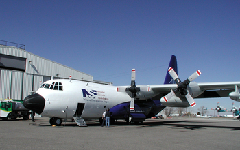
The NSF/NCAR C-130 aircraft includes pods on each wing where air-sampling instruments are mounted.
Credit and Larger Version

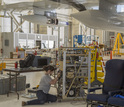
Scientists work on a data analysis console that will fly aboard the aircraft during FRAPPÉ.
Credit and Larger Version

How does ground level ozone form? Through complex chemistry from atmosphere to city street.
Credit and Larger Version

If you breathe the air, this alert is for you: Ozone levels affect all of us.
Credit and Larger Version
the National Science Foundation(NSF),
Guillermo Gonzalo Sánchez Achutegui

No hay comentarios:
Publicar un comentario