http://www.esa.int/esl/ESA_in_your_country/Spain/Sevilla
http://www.esa.int/spaceinimages/Images/2016/12/Siles_dam_subsidence
http://www.esa.int/spaceinimages/Images/2016/12/Proba-V_images_Mount_Everest
23 December 2016 – 10:00 CET
Earth from Space is presented by Kelsea Brennan-Wessels from the ESA Web-TV virtual studios. Join us every Friday at 10:00 CET for an 800 km-high tour of our planet.
23 December 2016 – 10:00 CET
Earth from Space is presented by Kelsea Brennan-Wessels from the ESA Web-TV virtual studios. Join us every Friday at 10:00 CET for an 800 km-high tour of our planet.

Sevilla
16 diciembre 2016
En esta imagen tomada por el satélite Sentinel-2A se contempla la zona oeste de la provincia de Sevilla, España, y su capital homónima (a la derecha).
La ciudad, que también es capital de la Comunidad Autónoma de Andalucía, se encuentra ubicada junto al río Guadalquivir. Además del curso original del río, que atravesaba serpenteante la ciudad por la derecha, a la izquierda podemos ver cómo el río fue reencauzado trazando una línea más recta.
El fértil valle del Guadalquivir destaca en la imagen por su multitud de estructuras agrícolas, especialmente apreciables en la esquina superior derecha de la fotografía. La cordillera de Sierra Morena, que se extiende al norte de la cuenca del Guadalquivir, nos muestra sus estribaciones en la esquina superior izquierda.
Otra formación que se aprecia claramente en la parte superior central de la imagen es una mina de cobre a cielo abierto, en color blanco. Este tipo de minería se suele practicar cuando hay depósitos de rocas o minerales cerca de la superficie.
Al oeste de esta mina, encontramos otras dos, llenas de agua.
Al sur de estas últimas vemos dos estructuras circulares que recuerdan a conchas. Se trata de grandes plantas solares, en las que los paneles se encuentran dispuestos mirando a una torre situada en la punta sur de las estructuras vistas en la imagen, que recibe la luz del sol concentrada y funciona a modo de caldera para producir energía.
Esta imagen, que también aparece en la galería de vídeos del programa Earth from Space, fue tomada por el satélite Sentinel-2A de Copernicus el 26 de julio de 2016.
Super moon

Details
- Title Super moon
- Released 16/12/2016 2:50 pm
- Copyright ESA/NASA
- DescriptionESA astronaut Thomas Pesquet took this image from on board the International Space Station. He posted it on social media, commenting: "This is tonight’s 'super moon' seen from space! The last one I saw was in Baikonur... I like this one better! ;)"Thomas' Proxima mission is the ninth long-duration mission for an ESA astronaut. It is named after the closest star to the Sun, continuing a tradition of naming missions with French astronauts after stars and constellations.During Proxima, Thomas will perform around 50 scientific experiments for ESA and France’s space agency CNES as well as take part in many research activities for the other Station partners. The mission is part of ESA’s vision to use Earth-orbiting spacecraft as a place to live and work for the benefit of European society while using the experience to prepare for future voyages of exploration further into the Solar System.Connect with Thomas Pesquet:
- Id 371078
TAGS
- Click on the tags to find the matching images.
- Activity Human Spaceflight
- Mission Proxima
- Keywords Moon
Siles dam subsidence
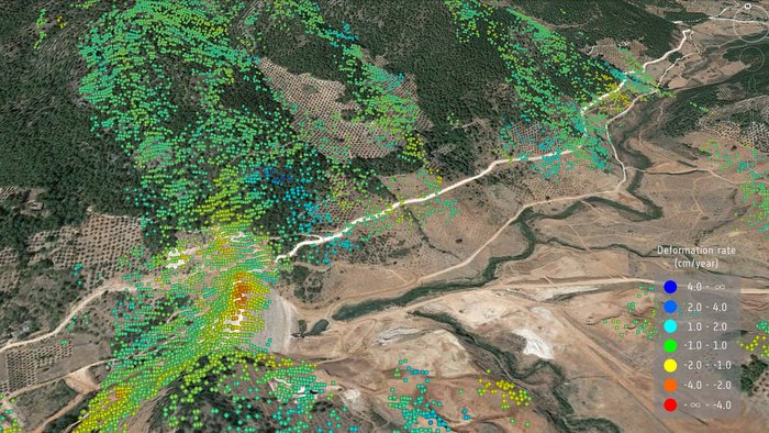
Details
- Title Siles dam subsidence
- Released 15/12/2016 12:00 pm
- Copyright IGEO, CSIC, UCM, DARES, Spanish research project RTC-2014-1922-5, Google Earth, contains modified Copernicus Sentinel data (2016)
- DescriptionThe Siles dam sits on the Guadalimar River in Spain’s Sierras de Cazorla natural park. Construction began in 2007 and was expected to be completed within three years but, through instabilities in the land, it was not completed until 2015.Using scans from the Sentinel-1 radar satellites between February and July 2016, scientists from Spain’s Institute of Geosciences – a joint centre of the Spanish Council for Scientific Research and the University Complutense of Madrid – in cooperation with the company Dares Technology, monitored subsidence of the dam.Some areas sank up to 3.6 cm over the five-month period, likely reflecting the settlement of the dam.The study demonstrates the viability of using Sentinel-1 radar data for monitoring critical hydrological infrastructures. While this kind of study is not new, this is the first time that a dam has been studied with Sentinel-1 data in Spain.These results were presented at the American Geophysical Union’s 2016 Fall Meeting held in San Francisco, USA.
- Id 370928
TAGS
- Click on the tags to find the matching images.
- Activity Observing the Earth
- Mission Sentinel-1
- System Copernicus
- Location Spain
- Keywords Dams and water basins , Radar
Proba-V images Mount Everest

Details
- Title Proba-V images Mount Everest
- Released 15/12/2016 1:36 pm
- Copyright ESA/Belspo – produced by VITO
- DescriptionProba-V – ESA’s smallest Earth-observing mission – overflies Mount Everest, the highest mountain in the world, its peak seen left of centre in this false-colour image.In honour of World Mountain Day on 11 December, this image depicts the snow-capped Himalayas, with Nepal to the south (with vegetation shown in red) and the bleaker Tibetan Plateau to the north.Mount Everest, the tallest mountain of the world at nearly 8850 m, is shown in white along with a few of its 8000 m-plus neighbours, including Kangchenjunga (8586 m), the third tallest mountain of the world, to the east of Everest. The Himalayas, which can be translated from Sanskrit as ‘abode of snow’, are the source of many major Asian rivers.Launched on 7 May 2013, Proba-V is a miniaturised ESA satellite tasked with a full-scale mission: to map land cover and vegetation growth across the entire planet every two days.Its main camera’s continent-spanning 2250 km swath width collects light in the blue, red, near-infrared and mid-infrared wavebands at 300 m resolution and down to 100 m resolution in its central field of view.VITO Remote Sensing in Belgium processes and then distributes Proba-V data to users worldwide. An online image gallery highlights some of the mission’s most striking images so far, including views of storms, fires and deforestation.This 100 m-resolution image was acquired by Proba-V on 27 October 2016.
- Id 370952
TAGS
- Click on the tags to find the matching images.
- Set Technology image of the week
TAGS
Spain

Siles dam subsidence
Asentamiento de la presa de Siles
16 diciembre 2016
La presa de Siles, que recoge las aguas del río Guadalimar, se encuentra dentro del Parque Natural de las Sierras de Cazorla, Segura y Las Villas, en España. Su construcción comenzó en 2007 y, pese a que debía completarse en tres años, no quedó acabada hasta 2015 debido a una serie de inestabilidades del terreno.
Empleando imágenes de barrido de los satélites Sentinel-1 entre febrero y julio de 2016, los científicos del Instituto de Geociencias —centro mixto del Consejo Superior de Investigaciones Científicas (CSIC) y la Universidad Complutense de Madrid— en cooperación con la empresa Dares Technology monitorizaron la subsidencia de la presa.
En algunas áreas, esta es de hasta 3,6 cm a lo largo de un periodo de cinco meses, lo que probablemente refleja que la presa se ha asentado.
El estudio demuestra la viabilidad del empleo de datos de Sentinel-1 para vigilar infraestructuras hidrológicas críticas. Aunque este tipo de estudios no es algo nuevo, es la primera vez que se estudia una presa mediante datos de Sentinel-1 en España.
Los resultados se presentaron en la Reunión de Otoño de la Unión Geofísica Americana (AGU), que tuvo lugar este mes de diciembre en San Francisco, Estados Unidos.
ESA
Guillermo Gonzalo Sánchez Achutegui
Inscríbete en el Foro del blog y participa : A Vuelo De Un Quinde - El Foro!

No hay comentarios:
Publicar un comentario