Hola amigos: A VUELO DE UN QUINDE EL BLOG., la Fundación Nacional de Ciencias de Los Estados Unidos, nos informan que huracanes gigantescos o monstruosos golpearon el Nor Este de los EE,UU.: The National Science Foundation (NSF). Huracanes intensos posiblemente más poderoso que cualquier tormenta de Nueva Inglaterra ha experimentado en la historia escrita con frecuencia golpean la región durante el primer milenio, desde el pico del Imperio Romano hasta la altura de la Edad Media, según los resultados de un nuevo estudio.
El hallazgo podría tener implicaciones para la comprensión de la intensidad y frecuencia de los huracanes los EE.UU. Noreste puede experimentar en el futuro.
El hallazgo podría tener implicaciones para la comprensión de la intensidad y frecuencia de los huracanes los EE.UU. Noreste puede experimentar en el futuro.
Scientists find clues in sediment deposits on Cape Cod
 Credit and Larger Version |
February 11, 2015
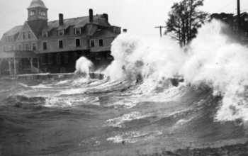
Intense hurricanes possibly more powerful than any storms New England has experienced in recorded history frequently pounded the region during the first millennium, from the peak of the Roman Empire to the height of the Middle Ages, according to results of a new study.
The finding could have implications for understanding the intensity and frequency of hurricanes the U.S. Northeast may experience in the future.
Looking back to see into the future
A record of sediment deposits from Cape Cod, Mass., shows evidence that 23 severe hurricanes hit New England between the years 250 and 1150, the equivalent of a severe storm about once every 40 years on average.
Many of these hurricanes were likely more intense than any that have hit the area in recorded history.
"The ability to produce and synthesize thousands of years of data on hurricane paths and frequencies is revolutionizing our understanding of what controls where and how often these dangerous storms make landfall," said Candace Major, program director in the National Science Foundation's Division of Ocean Sciences, which funded the research.
The prehistoric hurricanes were likely category 3 storms (such as Hurricane Katrina) or category 4 storms (Hurricane Hugo) that would be catastrophic if they hit the region today, according to Jeff Donnelly, a scientist at the Woods Hole Oceanographic Institution in Massachusetts, and lead author of a paper on the results published online today in Earth's Future, a journal of the American Geophysical Union.
Hurricane record extended by centuries
The study is the first to find evidence of historically unprecedented hurricane activity along the northern East Coast of the United States.
It also extends the hurricane record for the region by hundreds of years, back to the first century.
"These records suggest that the pre-historical interval was unlike what we've seen in the last few hundred years," said Donnelly.
The most powerful storm to hit Cape Cod in recent times was Hurricane Bob in 1991, a category 2 storm that was one of the costliest in New England history.
Storms of that intensity have only reached the region three times since the 1600s, according to Donnelly.
Warmer sea surface temperaturas
The intense prehistoric hurricanes were fueled in part by warmer sea surface temperatures in the Atlantic Ocean than have been the norm off the U.S. East Coast over the last few hundred years.
However, as ocean temperatures have slowly inched upward in recent decades, tropical North Atlantic sea surface temperatures have surpassed the warmth of prehistoric levels--and are expected to warm more over the next century as the climate heats up, Donnelly said.
"We hope this study broadens our sense of what is possible and what we should expect in a warmer climate," Donnelly said. "We may need to begin planning for a category 3 hurricane landfall every decade or so rather than every 100 or 200 years.
"The risk may be much greater than we anticipated."
Buried in sediment: hurricane remains
Donnelly and colleagues examined sediment deposits from Salt Pond near Falmouth on Cape Cod. The pond is separated from the ocean by a 1.3- to 1.8-meter (4.3 to 5.9-foot) high sand barrier.
Over hundreds of years, strong hurricanes have deposited sediment over the barrier and into the pond where it has remained undisturbed.
The researchers extracted nine-meter (30-foot) deep sediment cores, which they then analyzed in a laboratory.
Similar to reading a tree ring to tell the age of a tree and the climate conditions that existed in a given year, scientists can read a sediment core to determine when intense hurricanes occurred.
The paper's authors found evidence of 32 prehistoric hurricanes, along with the remains of three documented storms that occurred in 1991, 1675 and 1635.
The sediments showed that there were two periods of intense hurricane activity on Cape Cod -- from 150 to 1150, and 1400 to 1675.
The earlier period of powerful hurricane activity matched previous studies that found evidence of hurricanes during the same period in more southerly areas of the western North Atlantic Ocean basin--from the Caribbean to the Gulf Coast.
Powerful storms also battered more southerly U.S. coasts
The new study suggests that these powerful southern storms also battered the coast farther north through New England from 250 to 1150.
These early storms were more frequent, and in some cases were likely more intense, than the most severe hurricanes Cape Cod has seen in historical times, including Hurricane Bob in 1991 and a 1635 hurricane that generated a 20-foot storm surge, according to Donnelly.
The hurricane activity continued in the Caribbean and Gulf of Mexico until 1400, although there was a lull during this time in New England.
A shift in hurricane activity in the North Atlantic occurred around 1400, when activity picked up from the Bahamas to New England, until about 1675.
Co-authors of the paper are: Andrea Hawkes of the University of North Carolina Wilmington; Philip Lane (deceased); Dana MacDonald, University of Massachusetts, Amherst; Bryan Shuman, University of Wyoming; Michael Toomey, The University of Texas at Austin; Peter van Hengstum, Texas A&M University at Galveston; and Jonathan Woodruff, University of Massachusetts, Amherst.
-NSF-
Media Contacts Cheryl Dybas, NSF, (703) 292-7734, cdybas@nsf.gov
Nanci Bompey, AGU, (202) 777-7524, nbompey@agu.org
Stephanie Murphy, WHOI, (508) 289-2271, samurphy@whoi.edu
Nanci Bompey, AGU, (202) 777-7524, nbompey@agu.org
Stephanie Murphy, WHOI, (508) 289-2271, samurphy@whoi.edu
Related WebsitesNSF Grant: Tracking Sea-level Source Contributions: A Hemispheric Approach to High Resolution Sea-level Variation Over the Last Two Millennia:
The National Science Foundation (NSF) is an independent federal agency that supports fundamental research and education across all fields of science and engineering. In fiscal year (FY) 2015, its budget is $7.3 billion. NSF funds reach all 50 states through grants to nearly 2,000 colleges, universities and other institutions. Each year, NSF receives about 48,000 competitive proposals for funding, and makes about 11,000 new funding awards. NSF also awards about $626 million in professional and service contracts yearly.
Useful NSF Web Sites:
NSF Home Page:
http://www.nsf.gov
NSF News:
http://www.nsf.gov/news/
For the News Media:
http://www.nsf.gov/news/newsroom.jsp
Science and Engineering Statistics:
http://www.nsf.gov/statistics/
Awards Searches:
http://www.nsf.gov/awardsearch/

Scientists collect a sediment core; the sediment shows intense storms going back 2,000 years.
Credit and Larger Version

Sediment core section; light-colored sand at 22.7 feet down is evidence of an intense past storm.
Credit and Larger Version

Home in Union Beach, N.J., destroyed by a Hurricane Sandy storm tide in 2012.
Credit and Larger Version

Satellite view of Hurricane Earl as it threatens the U.S. East Coast in 2010.
Credit and Larger Version

Aerial image of Dauphin Island, Ala., following Hurricane Katrina in 2005.
Credit and Larger Versión
The National Science Foundation (NSF)
Guillermo Gonzalo Sánchez Achutegui
ayabaca@gmail.com
ayabaca@hotmail.com
ayabaca@yahoo.com
Inscríbete en el Foro del blog y participa : A Vuelo De Un Quinde - El Foro!

No hay comentarios:
Publicar un comentario