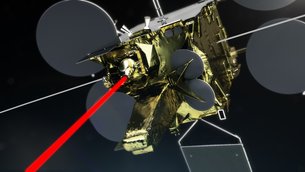
EDRS-A
23 noviembre 2016
El Sistema Europeo de Retransmisión de Datos (EDRS) comenzó ayer a dar servicio a Copernicus, el programa europeo de observación de la Tierra, transmitiendo las observaciones en tiempo casi real mediante la más moderna tecnología láser.
Marcando un hito sin precedentes, el EDRS, conocido como la ‘autopista espacial de la información’, ahora comenzará a prestar servicios comerciales a los satélites Sentinel del programa Copernicus de la Comisión Europea. Se trata de una colaboración público-privada entre la ESA y Airbus Defence and Space, en la que la agencia se ocupa del desarrollo tecnológico inicial y la compañía ofrece el servicio comercial. La Comisión Europea es el cliente de referencia del EDRS a través de sus misiones Sentinel-1 y Sentinel-2.
El EDRS agiliza la transmisión de datos desde satélites en órbita baja, como los Sentinel, hasta el usuario final en tierra. Para ello, intercepta los satélites en su paso mediante un haz láser, para retransmitir inmediatamente la información a las estaciones terrestres europeas por radio de alta velocidad.
Los satélites en órbita baja normalmente tienen que esperar a pasar por encima de una estación terrestre para poder enviar los datos recopilados, por lo que el retardo puede ser de hasta 90 minutos por cada 100 minutos de órbita. Esto se debe a que la mayoría de estaciones que sirven a estos satélites se encuentran en las regiones polares, aunque los Sentinel cuentan con estaciones adicionales en Italia y España.
Información espacial sin retraso
No obstante, los datos satelitales de observación de la Tierra se emplean cada vez más en aplicaciones en las que la rapidez es esencial, como la respuesta a desastres o la vigilancia y la seguridad marítima.
El EDRS ayudará a resolver este problema. Se trata de la primera red de comunicación mediante satélites ópticos en órbita geoestacionaria —órbita en la que los satélites tardan 24 horas en rodear la Tierra, por lo que parece que estuvieran parados en el espacio— y proporcionará cada día y en tiempo casi real una cantidad inaudita de datos con capacidad de salvar vidas.
El primer nodo, EDRS-A, ya va a comenzar a recopilar datos de Sentinel-1A. Los dos satélites se comunicrán mediante un haz láser hasta 15 veces al día.
El segundo, EDRS-C, será lanzado en 2017 y ayudará a transmitir la enorme cantidad de datos enviados y recibidos en Europa.
A diferencia del EDRS-A, alojado en un satélite comercial Eutelsat, el EDRS-C es un satélite dedicado, construido específicamente para el sistema.
Ambos transportan una carga útil TESAT con un terminal intersatelital láser desarrollado con financiación del Centro Aeroespacial Alemán (DLR). El EDRS-A también incorpora una carga útil intersatelital en banda Ka de alta velocidad que retransmite datos desde y hacia la Estación Espacial Internacional.

GlobeNet
Se prevé que en 2020 los dos primeros satélites se vean complementados por un tercer nodo, el EDRS-D, situado sobre Asia.
El EDRS-D forma parte del programa GlobeNet, que ampliará de Europa al resto del mundo la cobertura de retransmisión de datos en tiempo casi real del EDRS.
GlobeNet también establecerá contacto con naves tripuladas y pilotadas remotamente, ofreciendo comunicaciones bidireccionales que podrán utilizarse para comandar, controlar y descargar con rapidez datos de sensores, sumándose así a los datos obtenidos desde los satélites de observación de la Tierra.
Como resultado, se podrán recibir datos de observación de la Tierra en cualquier punto del planeta en tiempo casi real, lo que incrementará el valor de una gran variedad de aplicaciones en las que la velocidad es clave, como las de respuesta en caso de desastres o emergencias.
“Al ser el primer servicio comercial de retransmisión de datos que emplea láseres, el EDRS representa la innovación orientada al futuro al máximo nivel. La ESA va a seguir colaborando con Airbus Defence and Space y la Comisión Europea para superar los límites del progreso tecnológico, llevando el éxito del programa al resto del mundo con GlobeNet”, explica Magali Vaissiere, directora de Telecomunicaciones y Aplicaciones Integradas de la ESA.
Por su parte, Josef Aschbacher, director de los Programas de Observación de la Tierra de la ESA, comenta: “El EDRS abre una nueva dimensión de acceso a los datos a través de nuestros satélites Sentinel, permitiendo llegar más rápidamente a las imágenes y ofreciendo capacidad de respaldo a las estaciones receptoras terrestres. Algo cada vez más importante para satisfacer la creciente demanda de nuestras comunidades de usuarios”.
“La autopista espacial de la información ya no es ciencia ficción, sino que va a revolucionar las comunicaciones por satélite —añade Evert Dudok, director de Comunicaciones, Inteligencia y Seguridad de Airbus Defence and Space—. Va a cambiar radicalmente la forma en que se pueden gestionar las crisis humanitarias, la seguridad marítima y la protección del medio ambiente”.
Gerd Gruppe, miembro de la junta ejecutiva del DLR y responsable de la administración espacial, admite: “Alemania ha invertido estratégicamente en las comunicaciones ópticas y pretende continuar esta tendencia con el programa ‘ScyLight’ de la ESA. Esta es nuestra oportunidad de convertir el liderazgo tecnológico europeo en liderazgo en el mercado”.
Start of service for Europe’s SpaceDataHighway
EDRS-A
23 November 2016
The European Data Relay System began servicing Europe’s Earth observing Copernicus programme yesterday, transferring observations in quasi-real time using cutting-edge laser technology.
The EDRS–SpaceDataHighway will now begin providing a commercial service to the European Commission’s Copernicus Sentinels – the first and only of its kind. EDRS is a public–private partnership between ESA and Airbus Defence and Space, with ESA supporting the initial technology development and the company providing the commercial service. The European Commission is EDRS’s anchor customer through its Sentinel-1 and -2 missions.
EDRS accelerates the transmission of data from low-orbiting satellites like the Sentinels to the end user on the ground. It does so by locking onto the satellites with a laser beam as they pass below, and immediately relaying the information to European ground stations via a high-speed radio beam.
Low-orbiting satellites must usually wait until they travel within view of a ground station to downlink the data they have gathered, resulting in a delay of up to 90 minutes per 100-minute orbit. This is because most ground stations that serve low-orbiting satellites are located in the polar regions, although the Sentinels have additional stations in Italy and Spain.
Nevertheless, Earth observation satellite data are increasingly being used for time-sensitive applications like disaster response, maritime surveillance and security, where speed is of the essence.
EDRS will help to solve this problem. As the world’s first optical satellite communication network in ‘geostationary’ orbit – where satellites takes 24hr to circle Earth and thus appear to ‘hang’ in the sky – it will relay unprecedented amounts of potentially life-saving data per day in near-real time.
The EDRS-A first node will now start collecting data from Sentinel-1A. The two satellites will link via laser beam up to 15 times per day.
The EDRS-C second node will be launched in 2017 to help transfer the massive amounts of data being sent back and forth over Europe.
Unlike EDRS-A, which is hosted on a Eutelsat commercial satellite, EDRS-C is a dedicated satellite built specifically for the system.
Both nodes carry a TESAT payload with a laser intersatellite terminal developed under funding by the DLR German Aerospace Center. EDRS-A also carries a high-speed Ka-band intersatellite payload to relay data to and from the International Space Station.
GlobeNet
The first two satellites are planned to be complemented by the EDRS-D third node over Asia in 2020.
EDRS-D is part of a programme called GlobeNet, which will extend the EDRS quasi-realtime data relay coverage from Europe to worldwide.
GlobeNet will also link to both manned and remotely piloted aircraft, providing two-way communications that can be used for command, control and the rapid download of sensor data, complementing those obtained from Earth observation satellites.
The net result will be that Earth observation data can be received anywhere on Earth in near-real time, greatly increasing its value for a host of time-critical applications such as disaster and emergency response.
“As the first commercial data relay service in the world to use lasers, the EDRS–SpaceDataHighway represents forward-thinking innovation at its best. ESA will continue working with our partners, Airbus Defence and Space and the European Commission, to keep pushing the envelope of technological progress by extending this success to worldwide coverage with GlobeNet,” said Magali Vaissiere, ESA’s Director of Telecommunications and Integrated Applications.
“The EDRS–SpaceDataHighway offers a new dimension of data access from our Sentinel satellites, allowing faster access to images as well as a back-up capacity to classical ground receiving stations. This becomes increasingly important to satisfy the increasing demands of our user communities,” says Josef Aschbacher, ESA’s Director of Earth Observation Programmes.
“SpaceDataHighway is no longer science fiction, it will revolutionise satellite communications,” added Evert Dudok, Head of Communications, Intelligence & Security at Airbus Defence and Space.
“It will totally change the way humanitarian crisis, maritime safety and the protection of environment can be managed.”
“Germany has strategically invested in optical communication and intends to continue with the evolution in the ESA ‘ScyLight’ programme. Now we have chance to transform the European technological leadership into a market leadership,” said Dr Gerd Gruppe of DLR’s Executive Board, responsible for space administration.
Guillermo Gonzalo Sánchez Achutegui
ayabaca@gmail.com
ayabaca@yahoo.com
ayabaca@hotmail.com
Inscríbete en el Foro del blog y participa : A Vuelo De Un Quinde - El Foro!

No hay comentarios:
Publicar un comentario