Mostrando entradas con la etiqueta High-Resolution Stereo Camera (HRSC). Mostrar todas las entradas

jueves, 4 de octubre de 2012

Mars: Ice-coated beauty in Mars’ Silver Island


Download:
 HI-RES JPEG (Size: 2457 kb)  HI-RES TIFF (Size: 21 449 kb)
 High-Resolution Stereo Camera (HRSC) nadir and colour channel data taken during revolution 10743 on 8 June 2012 by ESA’s Mars Express have been combined to form a natural-colour view of Hooke Crater region in Argyre. Centred at around 45°S and 314°E, this image has a ground resolution of about 22 m per pixel. The image shows the western half of the 138 km-wide Hooke Crater, with wind formed dunes at its heart, while to the left of the crater, the ice-covered plains of Argyre Planitia are coated with a thin dusting of frozen carbon dioxide. The very large Argyre impact basin brought materials from the deeper martian crust and mantle to the surface. It provides scientists with one of the locations on Mars with a greater mixture of young/old and deep/surface terrains, providing a window into the planet’s past. 
Credits: ESA/DLR/FU Berlin (G. Neukum)

 On 8 June, the high-resolution stereo camera on Mars Express captured a region within the 1800 km-wide and 5 km-deep Argyre basin, which was created by a gigantic impact in the planet’s early history.
After Hellas, the Argyre impact basin is the second largest on the Red Planet. 
 
Download:
 HI-RES JPEG (Size: 564 kb)  HI-RES TIFF (Size: 15 690 kb)
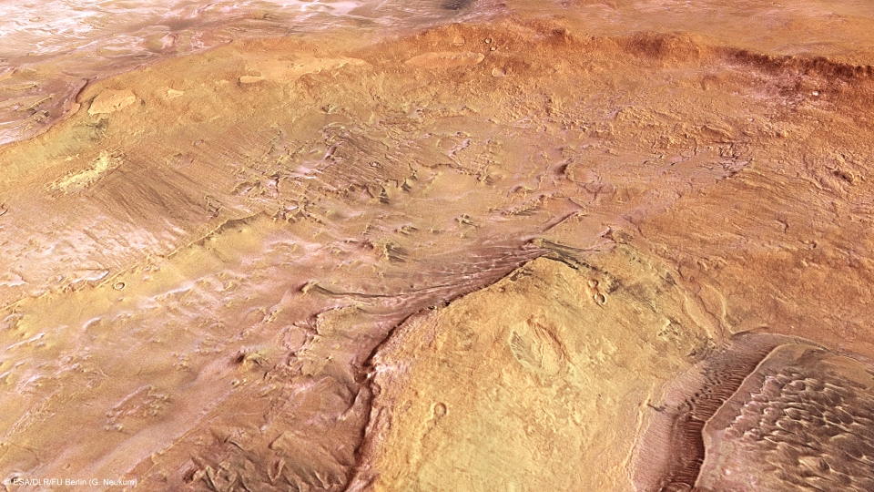
This computer-generated perspective view was created using data obtained from the High-Resolution Stereo Camera (HRSC) on ESA’s Mars Express. Centred at around 45°S and 314°E, this image has a ground resolution of about 22 m per pixel. The lower right of the image shows the wind-formed dunes within Hooke Crater, while small deposits of frozen carbon dioxide ice lie within the crater, the top left of the image starts to show the more extensive ice lying on the surrounding Argyre Planitia. 
Credits: ESA/DLR/FU Berlin (G. Neukum) 

The name stems from the Greek word ‘argyros’ (silver) and Argyre was an ‘island of silver’ in Greek and Roman mythology. Giovanni Schiaparelli, the famed Italian astronomer, gave the name to this bright region on Mars in his detailed 1877 map.
At the centre of the larger impact basin is a flat region known as Argyre Planitia. The Mars Express images in this release all show a portion of the northern part of this plain, with a large portion of each image dominated by the western half of the 138 km-wide Hooke Crater, named after the British physicist and astronomer Robert Hooke.


Download:
 HI-RES JPEG (Size: 178 kb)  HI-RES TIFF (Size: 3717 kb)
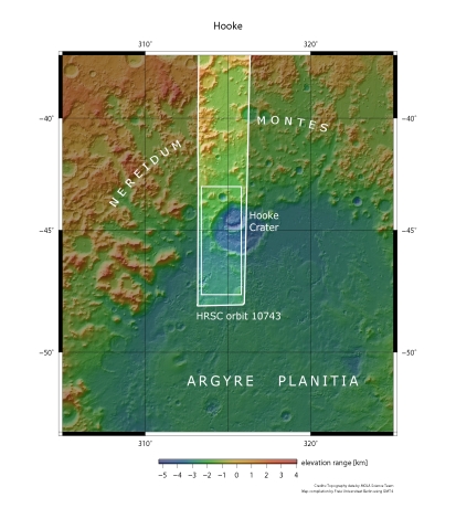
Hooke Crater and the surrounding Argyre Planitia are seen in broader context. The smaller rectangle shows the region covered in this ESA Mars Express HRSC image release. 
Credits: NASA MGS MOLA Science Team
Most of Argyre Planitia has been shaped by wind, glacial and lacustrine (lake-based) processes, creating the smoother appearance of the landscape surrounding Hooke Crater. Inside Hooke Crater itself, prevailing wind activity has formed dunes and helped to create linear erosion features, clearly seen in the following topographic image.


Download:
 HI-RES JPEG (Size: 2145 kb)  HI-RES TIFF (Size: 22 058 kb)
 This colour-coded plan view is based on a digital terrain model of the region, from which the topography of the landscape can be derived. The colour coding highlights the difference between the elevation of the hills to the right of the image and the depth of the Argyre Planitia region as well as Hooke Crater itself. This topographic map also increases the visibility and contrast of the dune features within Hooke Crater. Centred at around 45°S and 314°E, the image has a ground resolution of about 22 m per pixel. 
Credits: ESA/DLR/FU Berlin (G. Neukum)
 The most striking feature of this image release, shown clearly in the first image at the top of the page, is the icing sugar-like covering of the surface to the south (left) of the image. This is frost, but made of carbon dioxide, not water. Carbon dioxide ice is commonly seen on the surface of Mars, and has long been thought to form only at ground level, freezing out of the atmosphere as frost, which is most likely the case here.

 
Download:
 HI-RES JPEG (Size: 2187 kb)  HI-RES TIFF (Size: 17 817 kb)
 Argyre Planitia and Hooke Crater imaged during revolution 10743 on 8 June 2012 by ESA’s Mars Express using the High-Resolution Stereo Camera (HRSC). Data from HRSC’s nadir channel and one stereo channel are combined to produce this anaglyph 3D image that can be viewed using stereoscopic glasses with red–green or red–blue filters. Centred at around 45°S and 314°E, the image has a ground resolution of about 22 m per pixel. 
Credits: ESA/DLR/FU Berlin (G. Neukum)

 The lowlands to the south (left in the first image) of Hooke and regions within the crater are covered by a thin ice layer. However, it is lacking on the inner north-facing crater wall. It was probably melted there by the Sun, as indicated by the timing of the image.
Taken at around 4:30 in the local afternoon and during the southern hemisphere’s mid-winter, the Sun would have been just over 20 degrees above the horizon. It should then have been able to melt ice on the steeper north-facing slopes, but would probably not have had enough time to warm and melt any on low-lying horizontal surfaces.
Schiaparelli would doubtless have marvelled at the exquisite images coming back from Mars Express, which continues to provide today’s scientists with a bounty of wonderful data.
ESA
Guillermo Gonzalo Sánchez Achutegui
ayabaca@gmail.com
ayabaca@hotmail.com
ayabaca@yahoo.com
  Inscríbete en el Foro del blog y participa : A Vuelo De Un Quinde - El Foro!

sábado, 8 de septiembre de 2012

MARTE: El cráter Hadley proporciona nuevos datos sobre la geología marciana

Hola amigos: A VUELO DE UN QUINDE EL BLOG., Tras su reciente participación en el aterrizaje del laboratorio rodante ‘Curiosity’ de la NASA, la sonda Mars Express de la ESA ha retomado su misión principal, estudiando la geología y la atmósfera del Planeta Rojo.
 El cráter Hadley
Download:
 HI-RES JPEG (Size: 1310 kb)  HI-RES TIFF (Size: 75 289 kb)
High-Resolution Stereo Camera (HRSC) nadir and colour channel data taken during revolution 10572 on 9 April 2012 by ESA’s Mars Express have been combined to form a natural-colour view of Hadley Crater. Centred at around 19°S and 157°E, the image has a ground resolution of about 19 m per pixel. The image shows the main 120 km wide crater, with subsequent impacts at later epochs within it. Evidence of these subsequent impacts occurring over large timescales is shown by some of the craters being buried. 
Credits: ESA/DLR/FU Berlin (G. Neukum)
Tras su reciente participación en el aterrizaje del laboratorio rodante ‘Curiosity’ de la NASA, la sonda Mars Express de la ESA ha retomado su misión principal, estudiando la geología y la atmósfera del Planeta Rojo.

El pasado mes de abril la sonda estudió el cráter Hadley, de 120 km de diámetro, en el que descubrió nuevos datos sobre la estructura de la corteza marciana. Sus fotografías muestran un gran número de impactos salpicando las paredes del cráter principal, que alcanzan profundidades de hasta 2600 metros por debajo del nivel de la superficie circundante.  
 Vista en perspectiva del cráter Hadley
Download:
 This computer-generated perspective view of Hadley Crater was created using data obtained from the High-Resolution Stereo Camera (HRSC) on ESA’s Mars Express. Centred at around 19°S and 157°E, this image has a ground resolution of about 19 m per pixel. The ejecta blanket emanating from the deep crater in the middle of the image shows evidence for volatiles, possibly water ice, while the main crater rim to the top (south) of the image shows evidence for so-called “mass wasting”. This is a geomorphic process by which surface materials can move down a slope under the force of gravity. In this case, this process made the southern side of the crater shallower than its northern counterpart. 
Credits: ESA/DLR/FU Berlin (G. Neukum)
Estas imágenes, tomadas el 9 de abril de 2012 por la Cámara Estéreo de Alta Resolución (HRSC) de Mars Express, muestran la región al oeste del Valle Al-Qahira, en la zona de transición entre las antiguas tierras altas del sur y las tierras bajas del norte de Marte.
El cráter Hadley lleva el nombre del abogado y meteorólogo británico George Hadley (1685-1768), descubridor del sistema de circulación atmosférica responsable del transporte de calor y humedad entre el ecuador y los trópicos, conocido como las ‘células convectivas de Hadley’.
Estas fotografías revelan que el cráter Hadley continuó recibiendo impactos de asteroides y/o cometas tras su formación y posterior relleno con lava y sedimentos.
Algunos de estos impactos también han quedado parcialmente enterrados. En la parte superior (oeste) de la primera imagen de este artículo se pueden distinguir los bordes de varios cráteres, y en la parte derecha (norte) se aprecia un sistema de crestas sinuosas surcando la base del cráter principal.
 Entorno del cráter Hadley
Download:
 Hadley Crater in broader context. The smaller rectangle shows the region covered in this ESA Mars Express HRSC image release. Hadley Crater is west of the Al-Qahira Vallis in the transition zone between the old, southern highlands and the younger northern lowlands. 
Credits: NASA MGS MOLA Science Team
En esta primera imagen, parece que la cara sur (izquierda) del cráter es menos profunda que la norte. Esta diferencia podría ser el resultado de un proceso de erosión conocido como ‘remoción de masa’, que se produce cuando el material de la parte superior se desliza ladera abajo por acción de la gravedad. La remoción de masa puede desencadenarse por una serie de procesos, como terremotos, gelifracción, la erosión de la base de la ladera o la hidratación de los materiales que la componen. En este caso en concreto se desconoce cuál pudo haber sido la causa, o cuánto tiempo tardó en colapsar la ladera.
 Vista en perspectiva del cráter Hadley
Download:
 This computer-generated perspective view was created using data obtained from the High-Resolution Stereo Camera (HRSC) on ESA’s Mars Express. Centred at around 19°S and 157°E, the image has a ground resolution of about 19 m per pixel. This view shows several of the later craters within the main perimeter of Hadley. Fluidised ejecta can be seen both in the bottom right and top left craters, the latter crater reaching a depth of around 2600 m. Credits: ESA/DLR/FU Berlin (G. Neukum)
 Lo que ha despertado el interés de los científicos han sido los escombros arrancados de los cráteres más pequeños. Dos de ellos, uno al oeste (arriba) del cráter principal y otro próximo a su punto medio, están rodeados por una estructura que parece indicar la presencia de materiales volátiles bajo la superficie del planeta, probablemente agua helada. Los impactos que crearon estos cráteres habrían arrancado y fundido el hielo del subsuelo, mezclándose con los materiales de su entorno para formar una especie de ‘barro’ que se desparramó sobre la superficie que los rodea
 Vista topográfica del cráter Hadley
Download:
This colour-coded plan view is based on a digital terrain model of the region, from which the topography of the landscape can be derived. The colour coding highlights the depth of the central impact crater, reaching down almost 2600 m compared to the region surrounding Hadley Crater itself. Deep craters like these provide scientists with a view through the historical timeline of Mars’ formation. Centred at around 19°S and 157°E, the image has a ground resolution of about 19 m per pixel. 
Credits: ESA/DLR/FU Berlin (G. Neukum) 
 Los científicos piensan que estas estructuras podrían indicar la existencia de agua helada bajo la superficie de Marte, a una profundidad de varios cientos de metros. El estudio de estos cráteres nos ayudará a comprender mejor la historia de Marte, una historia que misiones como las que ya se encuentran en el Planeta Rojo (y las que les seguirán) nos permitirán seguir desvelando.

Vista en 3D del cráter Hadley
Download:
 Hadley Crater imaged during revolution 10572 on 9 April 2012 by ESA’s Mars Express using the High-Resolution Stereo Camera (HRSC). Data from HRSC’s nadir channel and one stereo channel are combined to produce this anaglyph 3D image that can be viewed using stereoscopic glasses with red–green or red–blue filters. The image shows the buried craters within the main Hadley Crater perimeter, as well as wrinkle ridges, created when the crust cools and contracts. Centred at around 19°S and 157°E, the image has a ground resolution of about 19 m per pixel. Credits: ESA/DLR/FU Berlin (G. Neukum)
 ESA
Guillermo Gonzalo Sánchez Achutegui
ayabaca@gmail.com
ayabaca@hotmail.com
ayabaca@yahoo.com
Inscríbete en el Foro del blog y participa : A Vuelo De Un Quinde - El Foro!

jueves, 5 de julio de 2012

Astronomy: Melas Dorsa reveals a complex geological history on Mars

Hi My Friends: A VUELO DE UN QUINDE EL BLOG., ESA’s Mars Express has imaged an area to the south of the famed Valles Marineris canyon on the Red Planet, showing a wide range of tectonic and impact features.

Download:
 HI-RES JPEG (Size: 508 kb)  HI-RES TIFF (Size: 86 750 kb)
High-Resolution Stereo Camera (HRSC) nadir and colour channel data taken during revolution 10532 on 17 April 2012 by ESA’s Mars Express have been combined to form a natural-colour view of the Melas Dorsa region. Centred at around 18°S and 288°E, this image has a ground resolution of about 18 m per pixel. The image shows the wrinkle ridges bisected by crustal displacement faults known as ‘en-echelon’ faults along with the large impact crater with its butterfly-shaped fluidised ejecta blanket. En-echelon faults are closely spaced, parallel overlapping or step-like fault structures, which in this view can be seen at the far left of the image, intersecting the wrinkle ridges.
Credits: ESA/DLR/FU Berlin (G. Neukum)
 ESA’s Mars Express has imaged an area to the south of the famed Valles Marineris canyon on the Red Planet, showing a wide range of tectonic and impact features.

On 17 April, the orbiter pointed its high-resolution stereo camera at the Melas Dorsa region of Mars. This area sits in the volcanic highlands of Mars between Sinai and Thaumasia Plana, 250 km south of Melas Chasma. Melas Chasma itself is part of the Valles Marineris rift system. The image captures wrinkle ridges, some unusual intersecting faults and an elliptical crater surrounded by ejecta in the shape of a butterfly and with a strange ‘fluid-like’ appearance. 

Download:
 This computer-generated perspective view was created using data obtained from the High-Resolution Stereo Camera (HRSC) on ESA’s Mars Express. Centred at around 18°S and 288°E, this image has a ground resolution of about 18 m per pixel. The 16 km-wide impact crater and its associated butterfly-shaped ejecta blanket takes up most of this image. The shape of the crater and ejecta blanket indicates a low-angle impact by a comet or asteroid. 
Credits: ESA/DLR/FU Berlin (G. Neukum)

Melas Dorsa impact crater perspective view

Elliptical craters like this 16 km-wide example are formed when asteroids or comets strike the surface of the planet at a shallow angle. Scientists have suggested that a fluidised ejecta pattern indicates the presence of subsurface ice which melted during the impact. Subsequent impacts have created a number of smaller craters in the ejecta blanket. 

Download:
 HI-RES JPEG (Size: 229 kb)
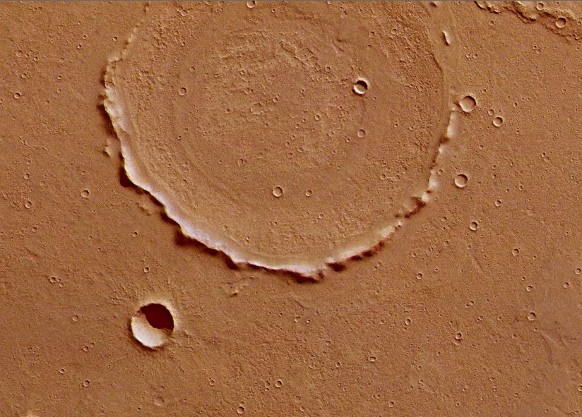
Zoom view of the flooded crater seen in the upper centre part of the main image. Credits: ESA/DLR/FU Berlin (G. Neukum)
The rim of another large crater is visible in the upper centre part of the image, but it appears mostly to have been almost buried during some distant epoch by volcanic dust and ash. This makes any detailed study of it almost impossible. However, its centre shows
concentric deposits that could provide insights into the composition of the volcanic material that buried it.  


Download:
 HI-RES JPEG (Size: 436 kb)  HI-RES TIFF (Size: 92 506 kb)
This colour-coded plan view is based on a digital terrain model of the region, from which the topography of the landscape can be derived. Notable here is the almost complete lack of relief change in the crater at the top of the image, which has been filled in by volcanic activity. Centred at around 18°S and 288°E, the image has a ground resolution of about 18 m per pixel.

Credits: ESA/DLR/FU Berlin (G. Neukum)
 
Melas Dorsa topography

Several wrinkle ridges can be seen across the image. These form when horizontal compression forces in the crust pushes the crust upwards. To the left, the ridges are bisected by crustal displacement faults. These have cut into the ridges and the surrounding surface at some later epoch. This highlights the different tectonic phases responsible the formation of this region.

Download:
 Melas Dorsa is seen here in broader context. The smaller rectangle shows the region covered in this ESA Mars Express HRSC image release. Melas Dorsa is located in the volcanic highlands of Mars between Sinai and Thaumasia Plana, approximately 250 km south of Melas Chasma. Melas Chasma itself belongs to the Valles Marineris rift system. 
Credits: NASA MGS MOLA Science Team


Download:
 Melas Dorsa imaged during revolution 10532 on 17 April 2012 by ESA’s Mars Express using the High-Resolution Stereo Camera (HRSC). Data from HRSC’s nadir channel and one stereo channel are combined to produce this anaglyph 3D image that can be viewed using stereoscopic glasses with red–green or red–blue filters. The image clearly shows the wrinkle ridges bisected by the en echelon fault lines. Centred at around 18°S and 288°E, the image has a ground resolution of about 18 m per pixel.

Credits: ESA/DLR/FU Berlin (G. Neukum)
 ESA
 Guillermo Gonzao Sánchez Achutegui
ayabaca@gmail.com 
ayabaca@hotamil.com
 ayabaca@yahoo.com
Inscríbete en el Foro del blog y participa : A Vuelo De Un Quinde - El Foro!

Mi lista de blogs