Mostrando entradas con la etiqueta Copernicus Sentinel-2. Mostrar todas las entradas

domingo, 26 de marzo de 2017

ESA : Deforestation in Rio Branco .- Deforestación en Rio Branco...

http://www.esa.int/spaceinvideos/Videos/2017/03/Deforestation_in_Rio_Branco


  • Watch in:
  • en
  • DOWNLOADMP4(3.01 MB)
    SOURCEMP4(36.14 MB)

    Details

    Open/Close
    • Title Deforestation in Rio Branco
    • Released: 21/03/2017
    • Length 00:12:00
    • Language English
    • Footage Type Animation
    • Copyright USGS/ESA/contains modified Copernicus Sentinel data (2016), processed by ESA
    • Description
      Deforestation near the northwestern Brazilian city of Rio Branco has made its mark on the rainforest over the last 30 years. By comparing a Landsat-5 image from 1985 with a Copernicus Sentinel-2 image from 2016, we can see where vegetation has been cleared away for logging, farming and other activities.
      Rainforests worldwide are being destroyed at an alarming rate. This is of great concern because they play an important role in global climate, and are home to a wide variety of plants, animals and insects. More than a third of all species in the world live in the Amazon Rainforest.
      Unlike other forests, rainforests do not grow back when they are destroyed and, owing to their composition, their soils are not suitable for long-term agricultural use.
      With their unique view from space, Earth observation satellites have been instrumental in highlighting the vulnerability of the rainforests by documenting the scale of deforestation, particularly in remote areas.
      In these false-colour images, vegetation appears red to help us better distinguish between vegetated and non-vegetated areas.

    ESA
    Guillermo Gonzalo Sánchez Achutegui
    ayabaca@gmail.com
    ayabaca@hotmail.com
    ayabaca@yahoo.com
    Inscríbete en el Foro del blog y participa : A Vuelo De Un Quinde - El Foro!

    domingo, 22 de enero de 2017

    ESA : Big Island, Hawaii .- Isla gigante de Hawaii

    http://www.esa.int/spaceinimages/Images/2017/01/Big_Island_Hawaii


    Details

    Open/Close
    • Title Big Island, Hawaii
    • Released 20/01/2017 10:00 am
    • Copyright contains modified Copernicus Sentinel data (2016), processed by ESA
    • Description
      The volcanic landscape of the largest island in the Hawaiian archipelago is pictured in this Sentinel-2A satellite image.
      Located in the central Pacific Ocean, the islands, atolls and islets of Hawaii developed from a hotspot in Earth’s mantle that leaked magma as the Pacific tectonic plate moved northwest, creating a trail of exposed rock.
      The island pictured here is the southeastern-most island – and therefore youngest of the chain – and is volcanically active. We can clearly see the Mauna Loa volcano in the upper left with the darker remnants of lava flows down its gentle slopes. The other active volcano, Kīlauea, can be seen smoking near the centre of the image. Both active volcanos sit within the Hawaii Volcanoes National Park.
      Throughout the image, the brown and black lava flows – the darker being younger – are interspersed with green forests and fields. The clouds in this very high-rainfall area are formed by trade winds from the northeast being blocked by the mountains in the middle of the ocean, which also leads to frequent heavy rainfall.
      On the centre-right side of the image along the coast, we can see a plume of steam where lava flows into the ocean. The lava is seeping out of a fissure in a nearby lava lake and making its way into the ocean.  Nearby, we can also see the discontinuation of a road, cut off by a lava flow.
      This image, also featured on the Earth from Space video programme, was captured by the Copernicus Sentinel-2A satellite on 27 October 2016.
      The Sentinel-2 mission comprises two satellites. Sentinel-2A has been in orbit since 2015; its twin, Sentinel-2B, is set for launch during the night of 6/7 March. Together, the satellites will revisit the same spot over the equator every five days, and even more often at higher latitudes.
    • Id 372014

    TAGS

    Open/Close

    ESA
    Guillermo Gonzalo Sánchez Achutegui
    ayabaca@gmail.com
    ayabaca@hotmail.com
    ayabaca@yahoo.com
    Inscríbete en el Foro del blog y participa : A Vuelo De Un Quinde - El Foro!

    domingo, 1 de enero de 2017

    ESA : China’s Tian Shan mountains.- Montañas de Tian Shan de China

    http://www.esa.int/spaceinimages/Images/2016/12/China_s_Tian_Shan_mountains


    Details

    Open/Close
    • Title China’s Tian Shan mountains
    • Released 23/12/2016 10:00 am
    • Copyright contains modified Copernicus Sentinel data (2016), processed by ESA
    • Description
      Sentinel-2A takes us over northwestern China near the border with Kazakhstan and Kyrgyzstan in this false-colour image.
      The mountains pictured are part of the Tian Shan range, which stretches about 2800 km across this border region, making it one of the longest mountain ranges in Central Asia.
      The glaciers of Tian Shan have lost about a quarter of their ice mass since the 1960s, and scientists estimate that half of the remaining glaciers will have melted by 2050. Glaciers are a key indicator of climate change, and their melting poses threats to communities living downstream.
      We know well that snow and clouds are both white – had this image been in true colour, we wouldn’t be able to differentiate between the two. But Sentinel-2’s imager can view the area in different parts of the spectrum, and can separate clouds from snow. In this image, clouds are white while snow appears blue. This is particularly important for mapping snow cover.
      A few clouds can been seen over the mountains near the centre of the image, with thicker cloud cover in the valleys to the north.
      The orange area on the right side of the image is part of the Bayanbulak Basin, a large grassland area of about 24 000 sq km. Although not pictured, the basin also hosts an important wetland and China’s very own ‘Swan lake’ – the highest-altitude breeding ground for swans in the world.
      This area of the Tian Shan mountains in China's Xinjiang Region became a UNESCO World Heritage Site in 2013.
      This image from the Copernicus Sentinel-2A satellite was captured on 18 November 2016, and is also featured on the Earth from Space video programme.
    • Id 371189

    TAGS

    Open/Close
    ESA
    Guillermo Gonzalo Sánchez Achutegui
    ayabaca@gmail.com
    ayabaca@hotmail.com
    ayabaca@yahoo.com
    Inscríbete en el Foro del blog y participa : A Vuelo De Un Quinde - El Foro!

    domingo, 27 de noviembre de 2016

    ESA : Comienza a funcionar la autopista espacial de la información europea

    http://www.esa.int/esl/ESA_in_your_country/Spain/Comienza_a_funcionar_la_autopista_espacial_de_la_informacion_europea

    EDRS-A
     
    23 noviembre 2016
    El Sistema Europeo de Retransmisión de Datos (EDRS) comenzó ayer a dar servicio a Copernicus, el programa europeo de observación de la Tierra, transmitiendo las observaciones en tiempo casi real mediante la más moderna tecnología láser.
    Marcando un hito sin precedentes, el EDRS, conocido como la ‘autopista espacial de la información’, ahora comenzará a prestar servicios comerciales a los satélites Sentinel del programa Copernicus de la Comisión Europea. Se trata de una colaboración público-privada entre la ESA y Airbus Defence and Space, en la que la agencia se ocupa del desarrollo tecnológico inicial y la compañía ofrece el servicio comercial. La Comisión Europea es el cliente de referencia del EDRS a través de sus misiones Sentinel-1 y Sentinel-2.
    El EDRS agiliza la transmisión de datos desde satélites en órbita baja, como los Sentinel, hasta el usuario final en tierra. Para ello, intercepta los satélites en su paso mediante un haz láser, para retransmitir inmediatamente la información a las estaciones terrestres europeas por radio de alta velocidad.
    Los satélites en órbita baja normalmente tienen que esperar a pasar por encima de una estación terrestre para poder enviar los datos recopilados, por lo que el retardo puede ser de hasta 90 minutos por cada 100 minutos de órbita. Esto se debe a que la mayoría de estaciones que sirven a estos satélites se encuentran en las regiones polares, aunque los Sentinel cuentan con estaciones adicionales en Italia y España. 
     
    Información espacial sin retraso
     
    No obstante, los datos satelitales de observación de la Tierra se emplean cada vez más en aplicaciones en las que la rapidez es esencial, como la respuesta a desastres o la vigilancia y la seguridad marítima.  
    El EDRS ayudará a resolver este problema. Se trata de la primera red de comunicación mediante satélites ópticos en órbita geoestacionaria —órbita en la que los satélites tardan 24 horas en rodear la Tierra, por lo que parece que estuvieran parados en el espacio— y proporcionará cada día y en tiempo casi real una cantidad inaudita de datos con capacidad de salvar vidas.
    El primer nodo, EDRS-A, ya va a comenzar a recopilar datos de Sentinel-1A. Los dos satélites se comunicrán mediante un haz láser hasta 15 veces al día.
    El segundo, EDRS-C, será lanzado en 2017 y ayudará a transmitir la enorme cantidad de datos enviados y recibidos en Europa.
    A diferencia del EDRS-A, alojado en un satélite comercial Eutelsat, el EDRS-C es un satélite dedicado, construido específicamente para el sistema.
    Ambos transportan una carga útil TESAT con un terminal intersatelital láser desarrollado con financiación del Centro Aeroespacial Alemán (DLR). El EDRS-A también incorpora una carga útil intersatelital en banda Ka de alta velocidad que retransmite datos desde y hacia la Estación Espacial Internacional.
     
    GlobeNet
     
    Se prevé que en 2020 los dos primeros satélites se vean complementados por un tercer nodo, el EDRS-D, situado sobre Asia.
    El EDRS-D forma parte del programa GlobeNet, que ampliará de Europa al resto del mundo la cobertura de retransmisión de datos en tiempo casi real del EDRS.
    GlobeNet también establecerá contacto con naves tripuladas y pilotadas remotamente, ofreciendo comunicaciones bidireccionales que podrán utilizarse para comandar, controlar y descargar con rapidez datos de sensores, sumándose así a los datos obtenidos desde los satélites de observación de la Tierra.
    Como resultado, se podrán recibir datos de observación de la Tierra en cualquier punto del planeta en tiempo casi real, lo que incrementará el valor de una gran variedad de aplicaciones en las que la velocidad es clave, como las de respuesta en caso de desastres o emergencias.
     “Al ser el primer servicio comercial de retransmisión de datos que emplea láseres, el EDRS representa la innovación orientada al futuro al máximo nivel. La ESA va a seguir colaborando con Airbus Defence and Space y la Comisión Europea para superar los límites del progreso tecnológico, llevando el éxito del programa al resto del mundo con GlobeNet”, explica Magali Vaissiere, directora de Telecomunicaciones y Aplicaciones Integradas de la ESA.
    Por su parte, Josef Aschbacher, director de los Programas de Observación de la Tierra de la ESA, comenta: “El EDRS abre una nueva dimensión de acceso a los datos a través de nuestros satélites Sentinel, permitiendo llegar más rápidamente a las imágenes y ofreciendo capacidad de respaldo a las estaciones receptoras terrestres. Algo cada vez más importante para satisfacer la creciente demanda de nuestras comunidades de usuarios”. 
    “La autopista espacial de la información ya no es ciencia ficción, sino que va a revolucionar las comunicaciones por satélite —añade Evert Dudok, director de Comunicaciones, Inteligencia y Seguridad de Airbus Defence and Space—. Va a cambiar radicalmente la forma en que se pueden gestionar las crisis humanitarias, la seguridad marítima y la protección del medio ambiente”.
    Gerd Gruppe, miembro de la junta ejecutiva del DLR y responsable de la administración espacial, admite: “Alemania ha invertido estratégicamente en las comunicaciones ópticas y pretende continuar esta tendencia con el programa ‘ScyLight’ de la ESA. Esta es nuestra oportunidad de convertir el liderazgo tecnológico europeo en liderazgo en el mercado”.
     

    Start of service for Europe’s SpaceDataHighway

    EDRS-A
     
    23 November 2016
    The European Data Relay System began servicing Europe’s Earth observing Copernicus programme yesterday, transferring observations in quasi-real time using cutting-edge laser technology. 
    The EDRS–SpaceDataHighway will now begin providing a commercial service to the European Commission’s Copernicus Sentinels – the first and only of its kind. EDRS is a public–private partnership between ESA and Airbus Defence and Space, with ESA supporting the initial technology development and the company providing the commercial service. The European Commission is EDRS’s anchor customer through its Sentinel-1 and -2 missions.
    EDRS accelerates the transmission of data from low-orbiting satellites like the Sentinels to the end user on the ground. It does so by locking onto the satellites with a laser beam as they pass below, and immediately relaying the information to European ground stations via a high-speed radio beam. 
    Low-orbiting satellites must usually wait until they travel within view of a ground station to downlink the data they have gathered, resulting in a delay of up to 90 minutes per 100-minute orbit. This is because most ground stations that serve low-orbiting satellites are located in the polar regions, although the Sentinels have additional stations in Italy and Spain.
     

    Nevertheless, Earth observation satellite data are increasingly being used for time-sensitive applications like disaster response, maritime surveillance and security, where speed is of the essence.   
    EDRS will help to solve this problem. As the world’s first optical satellite communication network in ‘geostationary’ orbit – where satellites takes 24hr to circle Earth and thus appear to ‘hang’ in the sky – it will relay unprecedented amounts of potentially life-saving data per day in near-real time. 
    The EDRS-A first node will now start collecting data from Sentinel-1A. The two satellites will link via laser beam up to 15 times per day.
    The EDRS-C second node will be launched in 2017 to help transfer the massive amounts of data being sent back and forth over Europe.
    Unlike EDRS-A, which is hosted on a Eutelsat commercial satellite, EDRS-C is a dedicated satellite built specifically for the system.
    Both nodes carry a TESAT payload with a laser intersatellite terminal developed under funding by the DLR German Aerospace Center. EDRS-A also carries a high-speed Ka-band intersatellite payload to relay data to and from the International Space Station.
     
    GlobeNet
     
    The first two satellites are planned to be complemented by the EDRS-D third node over Asia in 2020.
    EDRS-D is part of a programme called GlobeNet, which will extend the EDRS quasi-realtime data relay coverage from Europe to worldwide.
    GlobeNet will also link to both manned and remotely piloted aircraft, providing two-way communications that can be used for command, control and the rapid download of sensor data, complementing those obtained from Earth observation satellites.
    The net result will be that Earth observation data can be received anywhere on Earth in near-real time, greatly increasing its value for a host of time-critical applications such as disaster and emergency response.
     
    “As the first commercial data relay service in the world to use lasers, the EDRS–SpaceDataHighway represents forward-thinking innovation at its best. ESA will continue working with our partners, Airbus Defence and Space and the European Commission, to keep pushing the envelope of technological progress by extending this success to worldwide coverage with GlobeNet,” said Magali Vaissiere, ESA’s Director of Telecommunications and Integrated Applications.
    “The EDRS–SpaceDataHighway offers a new dimension of data access from our Sentinel satellites, allowing faster access to images as well as a back-up capacity to classical ground receiving stations. This becomes increasingly important to satisfy the increasing demands of our user communities,” says Josef Aschbacher, ESA’s Director of Earth Observation Programmes. 
    “SpaceDataHighway is no longer science fiction, it will revolutionise satellite communications,” added Evert Dudok, Head of Communications, Intelligence & Security at Airbus Defence and Space.
    “It will totally change the way humanitarian crisis, maritime safety and the protection of environment can be managed.”
    “Germany has strategically invested in optical communication and intends to continue with the evolution in the ESA ‘ScyLight’ programme. Now we have chance to transform the European technological leadership into a market leadership,” said Dr Gerd Gruppe of DLR’s Executive Board, responsible for space administration.
    ESA
    Guillermo Gonzalo Sánchez Achutegui
    ayabaca@gmail.com
    ayabaca@yahoo.com
    ayabaca@hotmail.com
    Inscríbete en el Foro del blog y participa : A Vuelo De Un Quinde - El Foro!

    ESA : Gibson Desert .- Desierto de Gibson

    http://www.esa.int/spaceinimages/Images/2016/11/Gibson_Desert

    Details

    Open/Close
    • Title Gibson Desert
    • Released 18/11/2016 10:00 am
    • Copyright contains modified Copernicus Sentinel data (2015), processed by ESA
    • Description
      The Sentinel-2A satellite takes us over the Gibson Desert in Western Australia in this false-colour image.
      Covering an area of over 150 000 sq km, the desert sports gravel terrains covered by desert grasses, as well as red sandy plains and dunefields. A drought in the 1980s forced the indigenous Pintupi people to the central-eastern area of the desert, where they made contact with Australian society in what is believed to be one of the last first-contact events in Australia.
      On the left side of this false-colour image we see many strange shapes in varying shades of blue. These are the remnants of areas purposefully burned by the Pintupi people to encourage plant growth or drive game animals into the open.
      Many of the Pintupi people moved to settlements when the British military began testing missile in the region in the 1950s. The areas that they had burned became overgrown, becoming even more susceptible to manmade or lightning-caused fires, which then burn out of control, leaving behind large burn scars.
      In the lower-right corner of the image we can make out a circular structure. This is the Connolly Basin impact crater, believed to have been formed around 60 million years ago. Some 9 km across, the rim rises 25–30 m above the crater’s basin.
      This image was captured by the Copernicus Sentinel-2A satellite on Christmas Day in 2015, and is also featured on the Earth from Space video programme.
    • Id 369124

    TAGS

    Open/Close

    TAGS

    Open/Close

    ESA
    Guillermo Gonzalo Sánchez Achutegui
    ayabaca@gmail.com
    ayabaca@hotmail.com
    ayabaca@yahoo.com
    Inscríbete en el Foro del blog y participa : A Vuelo De Un Quinde - El Foro!

    domingo, 2 de octubre de 2016

    ESA : Ouarkziz crater .- El Cráter Uarkziz en Argelia

    http://www.esa.int/spaceinimages/Images/2016/09/Ouarkziz_cráter

    Details

    Open/Close
    • Title Ouarkziz crater
    • Released 30/09/2016 10:00 am
    • Copyright Contains modified Copernicus Sentinel data (2016), processed by ESA
    • Description Part of the Anti-Atlas mountains bordering the Sahara Desert in western Algeria is pictured in this satellite image.
      The Anti-Atlas range was born from continental collision, and geologists believe it was once higher than the Himalayas, but was reduced through erosion.
      Here the land is mostly dry and barren as the mountains belong to the Saharan climate zone. But some stream channels created by occasional water runoff or from when the climate was much wetter than today, are visible.
      The circle at the centre of the image is the Ouarkziz crater. Some 3.5 km across, the crater was created when a meteor hit Earth less than 70 million years ago, when dinosaurs still roamed the planet.
      This image was captured by the Copernicus Sentinel-2A satellite on 9 March.
    • Id 365959

    TAGS

    Open/Close
    ESA
    Guillermo Gonzalo Sánchez Achutegui
    ayabaca@gmail.com
    ayabaca@hotmail.com
    ayabaca@yahoo.com
    Inscríbete en el Foro del blog y participa : A Vuelo De Un Quinde - El Foro!

    viernes, 30 de septiembre de 2016

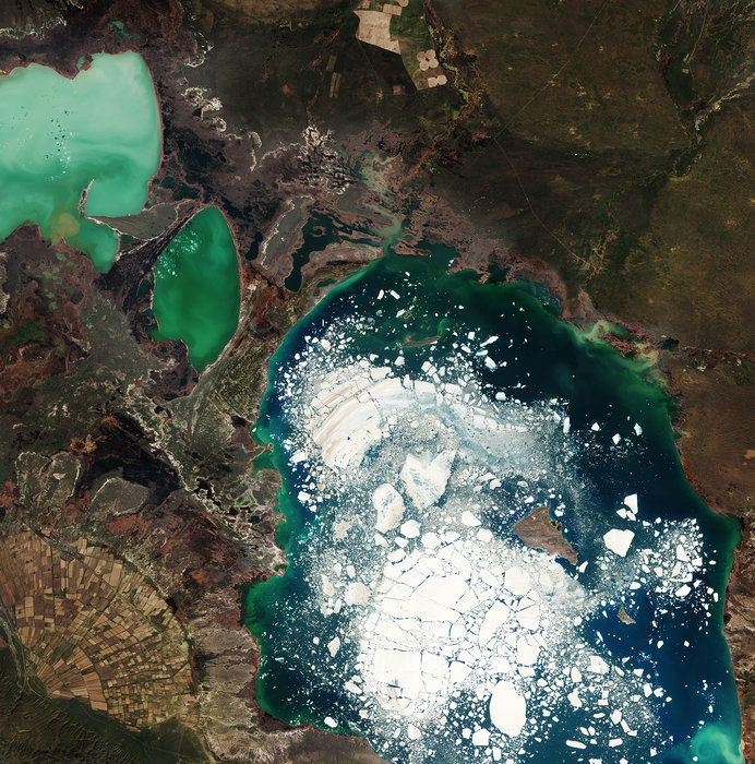
    ESA : Alakol Lake .- Lago Alakol en Kazajstán

    http://www.esa.int/spaceinimages/Images/2016/09/Alakol_Lake

    Details

    Open/Close
    • Title Alakol Lake
    • Released 23/09/2016 10:00 am
    • Copyright Contains modified Copernicus Sentinel data (2016), processed by ESA
    • Description Large chunks of broken ice float in east-central Kazakhstan’s Alakol Lake in this Copernicus Sentinel-2 image from 5 April 2016.
      This salt lake usually freezes for about two months at the end of winter, and breaks up in early spring – as we can see happening here. The lake’s mineral-rich water and mud is considered to be therapeutic, and tourists often visit the lake’s northern shores to remedy skin ailments.
      Alakol means ‘multicoloured lake’ – and we can clearly see varying shades of green and blue depending on the depth, sediments flowing in from rivers and streams and phytoplankton. The two smaller, shallower lakes to the northwest are Kosharkol and Sasykkol.
      The Alakol–Sasykkol lake system is both a Ramsar Wetland of International Importance and a UNESCO Biosphere Reserve. It is an important migratory stop and nesting area for a variety of water birds, including the Dalmatian Pelican and Greater Flamingo.
      In the lower-left corner of the image we can see agricultural structures in an alluvial fan. The triangular fan is formed when water runoff from the Dzungarian Alatau mountains (not pictured) hits the plain and spreads out, leaving behind fertile soil.
      This image is featured on the Earth from Space video programme.
    • Id 365539

    TAGS

    Open/Close

    ESA
    Guillermo Gonzalo Sánchez Achutegui
    ayabaca@gmail.com
    ayabaca@hotmail.com
    ayabaca@yahoo.com
    Inscríbete en el Foro del blog y participa : A Vuelo De Un Quinde - El Foro!

    Mi lista de blogs