Mostrando entradas con la etiqueta Italy. Mostrar todas las entradas

sábado, 25 de marzo de 2017

NASA : Space Station View of Mount Etna Erupting .- Vista desde la Estación Espacial Internacional de la erupción del Monte Etna....

https://www.nasa.gov/image-feature/space-station-view-of-mount-etna-erupting

     
Nighttime view from orbit of Sicily with red lines showing volcano eruption
The Expedition 50 crew aboard the International Space Station had a nighttime view from orbit of Europe's most active volcano, Mount Etna, erupting on March 19, 2017. Astronaut Thomas Pesquet of the European Space Agency captured this image and shared it with his social media followers, writing, "Mount Etna, in Sicily. The volcano is currently erupting and the molten lava is visible from space, at night! (the red lines on the left)."
Image Credit: ESA/NASA
Last Updated: March 22, 2017
Editor: Sarah Loff
NASA
Guillermo Gonzalo Sánchez Achutegui
ayabaca@gmail.com
ayabaca@hotmail.com
ayabaca@yahoo.com
Inscríbete en el Foro del blog y participa : A Vuelo De Un Quinde - El Foro!

domingo, 19 de marzo de 2017

ESA : Etna erupts .- El Etna estalla o erupciona.....

http://www.esa.int/spaceinimages/Images/2017/03/Etna_erupts

Details

Open/Close
  • Title Etna erupts
  • Released 16/03/2017 4:54 pm
  • Copyright contains modified Copernicus Sentinel data (2017), processed by ESA
  • Description
    This image of the lava flowing from Mount Etna in Sicily, Italy, was captured today at 10:45 GMT (11:45 CET) by the Copernicus Sentinel-2A satellite.
    Mount Etna is the largest active volcano in Europe and has one of the world’s longest records for continuous eruption. Today, however, there was a sudden explosion resulting in several people being injured.
    The red hot lava flowing from Mount Etna can be seen clearly in the image from Sentinel-2A. The surrounding snow has been processed in blue to distinguish from the clouds.
    Launched in June 2015, Sentinel-2A carries an innovative wide swath high-resolution multispectral imager with 13 spectral bands to monitor changes in land cover and vegetation.
    The mission is designed as a constellation of two satellites and its identical twin, Sentinel-2B, was launched just a few days ago, on 7 March.
  • Id 374715

TAGS

Open/Close
ESA
Guillermo Gonzalo Sánchez Achutegui
ayabaca@gmail.com
ayabaca@hotmail.com
ayabaca@yahoo.com
Inscríbete en el Foro del blog y participa : A Vuelo De Un Quinde - El Foro!

ESA : A ‘toast’ to Copernicus Sentinel-2B as it delivers its first images.- Un 'brindis' a Copernicus Sentinel-2B, ya que entrega sus primeras imágenes..


Brindisi, Italy
 
15 March 2017
Just over a week after being lofted into orbit, the European Union’s Sentinel-2B satellite delivered its first images of Earth, offering a glimpse of the ‘colour vision’ it will provide for the Copernicus environmental monitoring programme.
With a swath width of 290 km, the satellite’s first acquisition began over the Baltic Sea and made a strip-like observation through eastern Europe, ending in northern Libya.
The data were relayed in real time to the Matera ground station in Italy, where the images were then processed.
While eastern Europe was mostly cloudy, Italy’s sunny skies allowed the teams to get their first glimpse of the multispectral instrument’s capabilities over southern Italy’s Calabria and Apulia regions, the latter often referred to as the ‘heel of the boot’.
One of more distinctive features of this first acquisition is Apulia’s port city of Brindisi – appropriately the same word for the ‘toast’ ritual in Italian. Other areas captured in the first pass include the town of Crotone in Calabria and part of Albania's coast.
 

Crotone, Italy
 
The multispectral imager is being calibrated during the commissioning phase – which will take about three months.
Sentinel-2B is the second in the two-satellite mission for Europe’s Copernicus programme. Its twin Sentinel-2A was launched in June 2015. Now that both are in orbit, Sentinel-2 provides repeat coverage every five days.
In addition to demonstrating the high resolution of 10 m per pixel, these initial data foreshadow the mission’s land-monitoring applications in areas such as agriculture, coastal waters and land-cover mapping.
“Sentinel-2B will be one of the workhorses of Copernicus, as it will enable a whole range of applications with a focus on land,” said Josef Aschbacher, Director of ESA’s Earth Observation Programmes.
“With the second Sentinel-2 satellite in orbit, we now have much better coverage – which is especially important for monitoring areas frequently covered by clouds.
“This will further improve data availability of the Copernicus Services and increase the usage of the Copernicus data.”
 

Karavasta Lagoon, Albania
 
“The Copernicus Services in the areas of land and coastal monitoring rely on Sentinel-2 data,” said Philippe Brunet, Director for Space Policy, Copernicus and Defence at the European Commission.
“With the launch of the B-unit, the quality of the data products will increase and Copernicus can better manage and protect the environment and natural resources, as well as improve civil security.
Six families of Sentinel satellites will make up the core of EU’s Copernicus environmental monitoring network. An EU flagship space initiative, Copernicus provides operational information on the world’s land surfaces, oceans and atmosphere to support environmental and security policymaking, and meet the needs of citizens and service providers. 
ESA
Guillermo Gonzalo Sánchez Achutegui
ayabaca@gmail.com
ayabaca@hotmail.com
ayabaca@yahoo.com

domingo, 30 de octubre de 2016

ESA : Keep an automatic eye on seismic zones .- Mantengqa un ojo automático en las zonas sismicas

http://www.esa.int/Our_Activities/Observing_the_Earth/Copernicus/Sentinel-1/Keep_an_automatic_eye_on_seismic_zones

Keep an automatic eye on seismic zones

European seismic zones
 
28 October 2016
The Copernicus Sentinel-1 twin radar satellites combined with cloud computing are monitoring Europe’s earthquake zones by searching for ground shifts as small as a millimetre. 
Radar was developed in the last century to pick up aircraft moving at hundreds of kilometres per hour. Today’s satellite radar can reveal otherwise invisible shifts in the ground taking place as slowly as the growth of your fingernails.
The new, automatic radar service covers Europe’s seismic regions, monitoring an area of three million square kilometres in 200 m blocks.
Once any motion of interest has been identified, more detailed checks can be made through ESA’s Geohazards Exploitation Platform.
“The quick-browse service has been under way across European tectonic regions since January, harnessing automated processing developed by the DLR German Aerospace Center,” explains Fabrizio Pacini of Terradue, overseeing the Platform. 
 
Earthquake area in Italy

“Our plan next year is to gradually scale up to cover the entire world’s tectonic regions, which adds up to a quarter of Earth’s land surface.
“Such wide-area coverage is really unprecedented. It is a crucial step towards empowering society at large to reduce the risk from earthquakes and volcanoes.”
The satellites take successive radar images of the same location which are then combined to reveal the slightest shift.
Today, it is a well-established technique used to give authoritative snapshots of ground movements following events such as the recent earthquakes in central Italy.
Earth scientists were surprised in the 1980s when centimetre-accuracy GPS networks revealed previously unsuspected motion along tectonic plates, occurring between larger-scale seismic events. 
 
Ground displacement from Italy’s earthquake

Combined radar scans are sensitive down to a level of millimetres and over wide areas, compared to point-by-point GPS measurements, but the process demands heavy computing power.
“The real step change here is that they are being produced across extended areas on an entirely automated basis,” adds Fabrizio.
The service is processing an average 50 image pairs per day across Europe from the Sentinel-1A and Sentinel-1B satellites, with six days between coverage.
Next year, this will increase to 130 pairs per day, with a maximum of 24 days and potentially 12 days between acquisitions outside Europe, involving the daily processing of 1 terabyte of data, with additional higher resolution produced on request.
Processing on such a grand scale is enabled by the online, cloud-based Geohazards Exploitation Platform, specifically tailored for working with vast amounts of satellite data.
 
Geohazards TEP
 

Related articles

29 August 2016
 On 24 August, an earthquake struck central Italy, claiming at least 290 lives and causing widespread damage. Satellite images are being used to help emergency aid organisations, while scientists have begun to analyse ground movement.
12 May 2016
While the growing volume information from satellites observing Earth offers a unique opportunity for science and applications, it is sometimes difficult to make sure these complex data streams are exploited to their full potential. ESA is addressing t... 
ESA
Guillermo Gonzalo Sánchez Achutegui
ayabaca@gmail.com
ayabaca@hotmail.com
ayabaca@yahoo.com
Inscríbete en el Foro del blog y participa : A Vuelo De Un Quinde - El Foro!

domingo, 2 de octubre de 2016

domingo, 4 de septiembre de 2016

ESA : Sentinel-1 provides new insight into Italy’s earthquake .- Sentinel-1 proporciona nuevos conocimientos sobre el terremoto de Italia

http://www.esa.int/Our_Activities/Observing_the_Earth/Copernicus/Sentinel-1/Sentinel-1_provides_new_insight_into_Italy_s_earthquake

Ground displacement from Italy’s earthquake
29 August 2016
On 24 August, an earthquake struck central Italy, claiming at least 290 lives and causing widespread damage. Satellite images are being used to help emergency aid organisations, while scientists have begun to analyse ground movement.
The Italian peninsula is prone to earthquakes because of the continuing collision of the African and Eurasian tectonic plates. Under the Apennine mountain chain, the regional collision is causing the African slab to flex and dip under the Tyrrhenian Sea, while at the same time retreating northeastwards.
The slab's retreat is the main process driving the present tectonic extension which causes earthquakes like this one and the 2009 quake that devastated L'Aquila.
Under the coordination of the Italian Department of Civil Protection, scientists from Italy’s National Institute for Geophysics and Volcanology and the Institute for Electromagnetic Sensing of the Environment of the National Research Council are studying data from the Sentinel-1 satellite mission and other spaceborne radar missions to map surface deformations caused by the earthquake.
 
Italy earthquake deformation

The team found that the main deformation pattern shows subsidence reaching about 20 cm in the Accumoli area, and sideways movement of up to 16 cm.
The scientists use a technique that allows them to map surface deformations by comparing radar images over the affected area taken before and after the event.
The team has benefited from the availability of both Sentinel-1A and Sentinel-1B scans. The scientists were able to quantify the ground movement in both vertical and east–west directions by combining the radar scans obtained as the satellites flew both south to north and north to south.
Sentinel-1 is not the only satellite providing information on this recent quake: scientists are also relying on data from the Italian space agency’s Cosmo-SkyMed satellites, as well as satellite imagery from other space agencies.
In addition, data from a multitude of Copernicus contributing missions are being used to produce maps through the Copernicus Emergency Management Service for damage assessment.
 
Source fault of Italy’s earthquake
 
Sentinel-1 is a two-satellite mission for Europe’s Copernicus environment monitoring programme, led by the European Commission. The first satellite – Sentinel-1A – was launched in 2014, while its sister Sentinel-1B is still in its commissioning phase following launch just four months ago.
With its 250 km-wide swatch over land surfaces, Sentinel-1 gives scientists a broad view of the displacement, allowing them to examine the ground displacement caused by this earthquake and develop the scientific knowledge of quakes.
Once Sentinel-1B is operational next month, it will be possible to perform routine scans over critical areas like Italy every six days with the two-satellite constellation.

Related articles

Envisat interferogram over the L'Aquila area


ESA
Guillermo Gonzalo Sánchez Achutegui
ayabaca@gmail.com
ayabaca@hotmail.com
ayabaca@yahoo.com
Inscríbete en el Foro del blog y participa : A Vuelo De Un Quinde - El Foro!

lunes, 27 de agosto de 2012

CAVES: Astronauts searching for life – underground

Hi My Friends: A VUELO DE UN QUINDE EL BLOG., Astronauts dream of finding new life and for a select crew that dream might be within reach this week - albeit deep underground instead of in outer space.

Download:
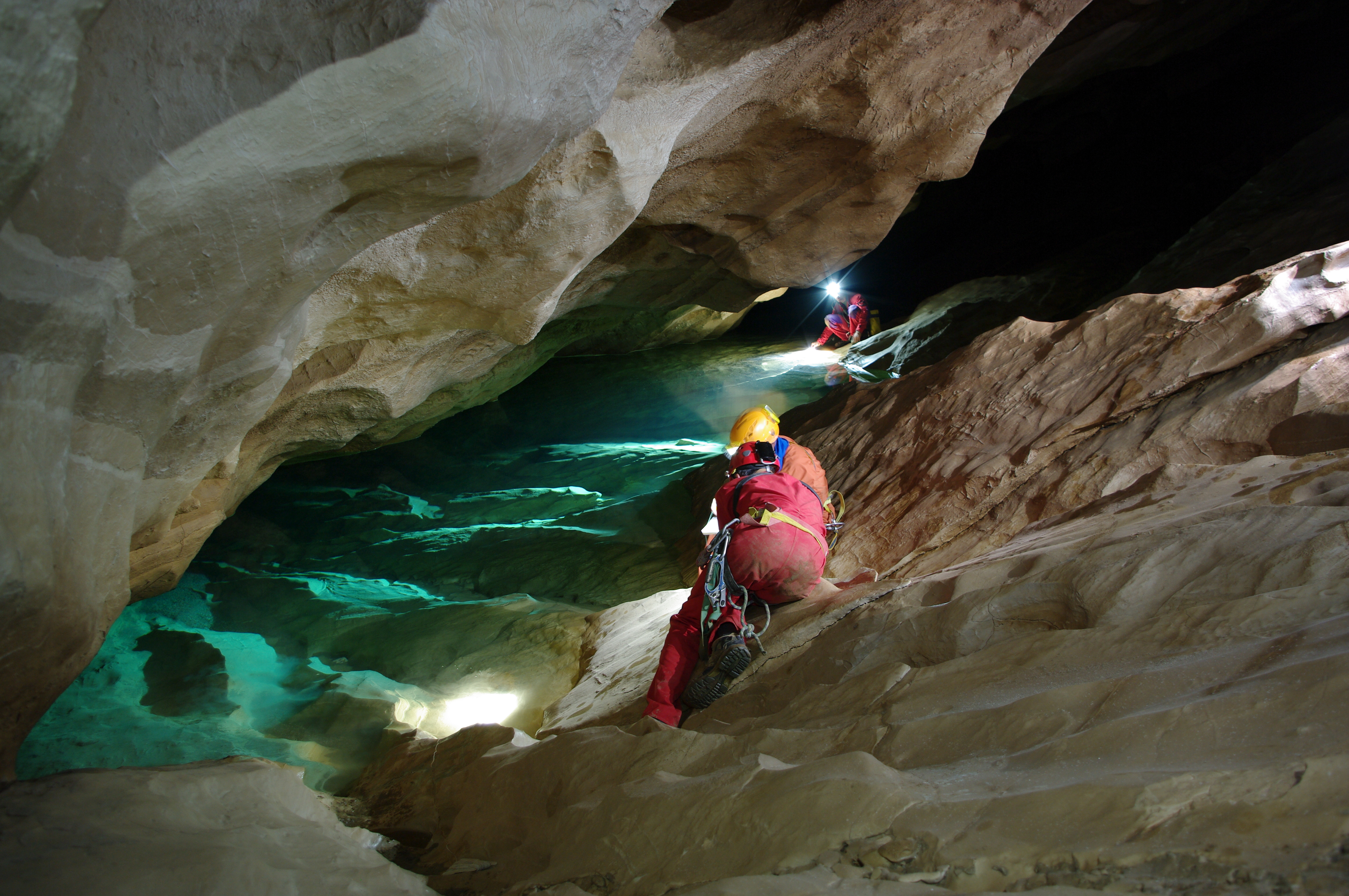
 Astronauts exploring Sardinian caves.
ESA’s cave training prepares astronauts to work as an international team in real exploration conditions. Sending astronauts underground to survive and explore Sardinian caves in Italy for almost a week is just one element of their long training.
The caves are isolated from the outside world. The astronauts need to get used to confined spaces, minimal privacy, technical challenges and limited equipment and supplies for hygiene and comfort – just as in space. Credits: ESA–R. Bresnik
 
An international crew of six astronauts will start training for a caving adventure designed to prepare them for spaceflight.
CAVES, an abbreviation of Cooperative Adventure for Valuing and Exercising human behaviour and performance Skills, prepares astronauts to work safely and effectively and solve problems as a multicultural team while exploring uncharted areas using space procedures.
The sunny island of Sardinia in Italy will welcome the astronauts from all the partners of the International Space Station. After a week spent learning the safety procedures and basics of exploring caves, the astronauts will venture underground on 7 September for six days.  
Download:
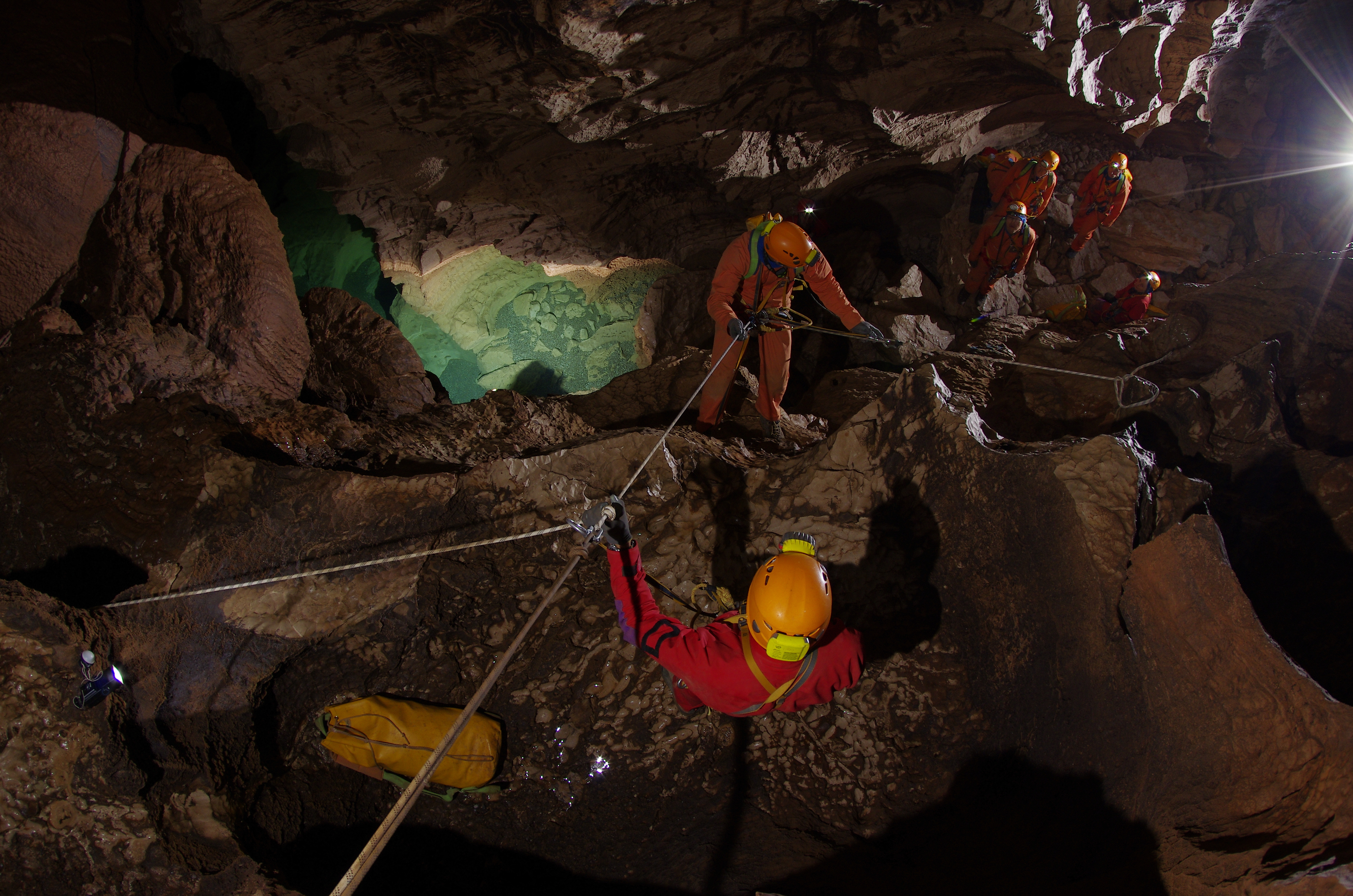
A ‘cavewalk’. Moving in a cave is similar to a spacewalk. It requires safety tethering, 3D orientation, with no-touch areas (speleothemes) and exclusion zones (dangerous paths). As in a spacewalk the view is stunning.
ESA’s cave training prepares astronauts to work as an international team in real exploration conditions. Sending astronauts underground to survive and explore Sardinian caves in Italy for almost a week is just one element of their long training.
The caves are isolated from the outside world. The astronauts need to get used to confined spaces, minimal privacy, technical challenges and limited equipment and supplies for hygiene and comfort – just like in space. 
Credits: ESA–V. Crobu
 Caves offer many similarities to space travel. Working in isolation from the outside world in confined spaces with minimal privacy as well as coping with technical challenges and limited supplies are conditions that astronauts have to live with in space – and underground.
The experience is designed to be as realistic as possible. A dedicated mission control will monitor the crew from a base station at the entrance of the cave. Briefings are held twice a day as they are on the International Space Station.
The crew is allowed only one shipment of supplies during their stay underground. They will have to choose the equipment carefully and give mission control at least 24 hours’ notice to prepare the cargo.
Orientation phase of CAVES 2011.
ESA’s cave training prepares astronauts to work as an international team in real exploration conditions. Sending astronauts underground to survive and explore Sardinian caves in Italy for almost a week is just one element of their long training.
The caves are isolated from the outside world. The astronauts need to get used to confined spaces, minimal privacy, technical challenges and limited equipment and supplies for hygiene and comfort – just like in space. Credits: ESA–V. Crobu
Looking for life

The opportunity to conduct research will not be lost. Just as in space, the astronauts have a busy schedule performing scientific work as well as testing new equipment and procedures.
A large part of the Sardinian caves are unexplored or uncharted. The ‘cavenauts’ will have to navigate safely through passages while deciding which areas to explore. They will draw detailed maps of their progress to ensure they make it back to base camp and to help future cave explorers.
This year the astronauts will be searching for life-forms as well. “Nobody has systematically looked for life in these caves,” says ESA astronaut trainer and CAVES course designer Loredana Bessone.


Life spotted in cave. ESA’s cave training prepares astronauts to work as an international team in real exploration conditions. Sending astronauts underground to survive and explore Sardinian caves in Italy for almost a week is just one element of their long training.
The Sardinian caves are isolated from the outside world. The astronauts need to get used to confined spaces, minimal privacy, technical challenges and limited equipment and supplies for hygiene and comfort – just like in space. 
Credits: ESA–F. Sauro
 “Finding life big and small is always good, so I am very excited we will be looking for exotic bacteria and cave dwellers such as anthropods.”
The astronauts will use the same safety protocols as used on spacewalks and they will also test a new communication system.
With support from their trainers, the astronauts will analyse their team-working skills and leadership qualities during the two-week course.
  ESA
G
 
Guillermo Gonzalo Sánchez Achutegui

 ayabaca@gmail.com
 ayabaca@hotmail.com
 ayabaca@yahoo.com
 Inscríbete en el Foro del blog y participa : A Vuelo De Un Quinde - El Foro!

domingo, 24 de junio de 2012

Earth from Space: Glacial shapes and waters

Hi My Friends: A VUELO DE UN QUINDE EL BLOG., Italy’s Lake Garda and the city of Verona south of the Italian Alps are pictured in this image from Japan’s ALOS observation satellite.
Download:
Italy’s Lake Garda and the city of Verona south of the Italian Alps are pictured in this image from ALOS observation satellite. With an area of 370 sq km, Garda is the largest lake in Italy and the third largest in the Alpine region. East of the lake is the Adige River, flowing south before curving east toward Verona. The city of Verona has been awarded World Heritage Site status by UNESCO because of its urban structure and architecture – among them the circular Roman amphitheatre, visible when zooming in.
The Advanced Land Observation Satellite captured this image on 21 October 2010 with its AVNIR-2 Advanced Visible and Near Infrared Radiometer. ALOS was supported as a Third Party Mission, which means that ESA used its multi-mission ground systems to acquire, process, distribute and archive data from the satellite to its user community. 
Credits: JAXA, ESA

Italy’s Lake Garda and the city of Verona south of the Italian Alps are pictured in this image from Japan’s ALOS observation satellite.

With an area of 370 sq km, Garda is the largest lake in Italy and the third largest in the Alpine region. It was formed by glaciers flowing out of the Alps during the last Alpine ice age, which ended around 12 000 years ago.
East of the lake is the Adige River, flowing south before curving east toward Verona. At 410 km in length, it is the second longest river in the country after the River Po.
If the water level in the river is too high, excess water is diverted to Lake Garda through a tunnel at the northern tip of the lake. This reduces the risk of flooding in Verona and the surrounding areas.
The tunnel is used only when absolutely necessary since the sudden influx of the river’s water, which is both colder than the lake's and more polluted, causes a temperature shock and degrades the habitat for fish.
The city of Verona has been awarded World Heritage Site status by UNESCO because of its urban structure and architecture – among them the circular Roman amphitheatre, visible when zooming in. The city is also the setting of William Shakespeare’s Romeo and Juliet.
The Advanced Land Observation Satellite captured this image on 21 October 2010 with its AVNIR-2 Advanced Visible and Near Infrared Radiometer.
ALOS was supported as a Third Party Mission, which means that ESA used its multi-mission ground systems to acquire, process, distribute and archive data from the satellite to its user community.
In April 2011 the satellite abruptly lost power while mapping Japan’s tsunami-hit coastline.  

The Image of the Week is featured on ESA Web-TV, broadcast online every Friday at 10:00 CEST.
ESA
Guillermo Gonzalo Sánchez Achutegui
ayabaca@gmail.com 
 ayabaca@hotmail.com
 ayabaca@yahoo.com
 Inscríbete en el Foro del blog y participa : A Vuelo De Un Quinde - El Foro!

domingo, 6 de mayo de 2012

The Earth: Spotlight on Sentinel-2

Hi My Friends: A VUELO DE UN QUINDE EL BLOG., The vast potential of ESA’s upcoming Sentinel-2 satellites came into focus last week at a symposium in Italy on how they will benefit current and future projects that exploit Earth observation data.

Download:
 HI-RES JPEG (Size: 644 kb)

Forest cover maps of Gabon in 1990, 2000 and 2010 derived from Landsat data. Green areas represent forests, while yellow areas depict no forest cover. Grey represents no data coverage.
Credits: SIRS
The vast potential of ESA’s upcoming Sentinel-2 satellites came into focus last week at a symposium in Italy on how they will benefit current and future projects that exploit Earth observation data.

The humid and moist tropical climate of Gabon yields immense forests that cover over 85% of the land, making them the number-two driver of the national economy – and deforestation a subject of concern.
The GMES project on Forest Monitoring Reducing Emissions from Deforestation and Degradation mapped deforestation in Gabon from 1990 to 2010 using NASA’s Landsat satellite.
But the Equatorial African country’s heavy cloud cover means that imagery is often difficult to acquire over some areas.
While it takes Landsat 1.5–3.5 years to obtain imagery of the entire country, the future Sentinel-2 mission would require less than a year because of its more frequent coverage.
The future monitoring of land cover by Sentinel-2 was just one of the many topics covered at the Sentinel-2 Preparatory Symposium, hosted this week at ESA’s ESRIN centre for Earth observation in Frascati, Italy.  

Download:
 HI-RES JPEG (Size: 1952 kb)
  HI-RES TIFF (Size: 25 250 kb)


A mockup of the high-resolution images that the future Sentinel-2 mission will deliver, with a swath of 290 km and a resolution of 10 m per pixel. Using 82 observations from the German RapidEye satellites, the image covers the border area of northern Switzerland, southern Germany and eastern France, and includes a small portion of Austria and Lichtenstein. Sentinel-2, envisaged for launch in 2013, is one of five Sentinel missions that ESA is developing for Europe’s Global Monitoring for Environment and Security (GMES) programme.
Credits: RapidEye

Other applications discussed include forestry, agriculture, cartography and the mapping of glaciers and wetlands.
“Sentinel-2 will fill the gap from both a research and operations perspective,” said Chris Steenmans, Head of Programme at the European Environment Agency’s Shared Environmental Information System.
“We are currently struggling with fragmented satellite data, so the timely information that Sentinel-2 will provide is important. The mission will also complement other Earth observation investments on a global level.”
Sentinel-2, planned for launch next year, is one of five Sentinel missions that ESA is developing for Europe’s Global Monitoring for Environment and Security (GMES) programme.
Through GMES, decision-makers will have access to reliable, timely and accurate information services to manage the environment, understand and mitigate the effects of climate change and ensure civil security.
At the recent symposium, Medhavy Thankappan, Director of Science and Strategy at Geoscience Australia’s National Earth Observation Group, presented a national land cover dataset based on analysis of satellite data acquired over an eight-year period.

Download:
 HI-RES JPEG (Size: 1582 kb)


Sentinel-2 will provide systematic global acquisitions of high-resolution multispectral imagery for Europe's Global Monitoring for Environment and Security (GMES) programme.
Credits: Astrium GmbH

The dataset will provide the basis for monitoring Australia’s water resources, agricultural practices, soil erosion and forests.
“The next step is to update the land cover information with new data from a consistent source – to move from mapping to monitoring,” said Mr Thankappan.
“We would also like to move to a higher spatial resolution – that’s where Sentinel-2 comes in.”
Owing to its high resolution of 10 m per pixel, and wide swath of 290 km, global products from Sentinel-2 will be able to be applied locally.
The mission will adhere to the Sentinel Data Policy, which establishes full and open access to data acquired by all five of the upcoming Sentinels.
Participants at the symposium, however, expressed concern over the data delivery arrangement.
“Sentinel-2 is like a dream come true for the forest remote sensing community,” said Tuomas Häme, Research Professor at the VTT Technical Research Centre of Finland.
“It is of utmost importance that the mission can be fully utilised by organising data delivery to the users as smoothly as it is organised for the similar missions with a free and open data policy.”
ESA.
Guillermo Gonzalo Sánchez Achutegui
ayabaca@gmail.com
ayabaca@hotmail.com
ayabaca@yahoo.com
Inscríbete en el Foro del blog y participa : A Vuelo De Un Quinde - El Foro!

Mi lista de blogs