Mostrando entradas con la etiqueta High Resolution Stereo Camera (HRSC). Mostrar todas las entradas

viernes, 27 de diciembre de 2013

ESA : Mars Express se dirige a un atrevido encuentro con Fobos


Vista de Fobos en 360 grados

Mars Express se dirige a un atrevido encuentro con Fobos

26 diciembre 2013
A finales de este mes la sonda Mars Express de la ESA se acercará más que nunca a la mayor luna de Marte: Fobos, sobrevolando su superficie a tan sólo 45 kilómetros de altitud.
El próximo día 29 de diciembre Mars Express pasará tan cerca de Fobos y tan rápido que no va a ser capaz de tomar imágenes, pero la maniobra servirá para tomar los datos más precisos hasta la fecha del campo gravitatorio de esta luna, que nos ayudarán a conocer mejor su estructura interna.
El campo gravitatorio de Fobos alterará levemente la trayectoria de la sonda europea, variando su velocidad unos pocos centímetros por segundo. Estas pequeñas variaciones se reflejarán en las señales de radio que Mars Express envía a la tierra, y los científicos las podrán relacionar con la densidad y con la distribución de masa en el interior de la luna.
Imagen de Fobos tomada por la cámara HRSC de Mars Express el 7 de marzo de 2010
Las aproximaciones anteriores, como la de marzo de 2010, cuando la sonda se acercó a 67 km de Fobos, sugieren que entre un cuarto y un tercio de la luna están vacíos – Fobos es básicamente una pila de escombros con grandes espacios entre las rocas que componen su interior.
El estudio de la estructura de esta luna de 27 x 22 x 18 kilómetros nos ayudará a resolver el gran misterio que rodea su origen y el de su hermano Deimos, que orbita alrededor de Marte a una distancia tres veces superior.
Las principales teorías sugieren que estas dos lunas podrían ser asteroides capturados por Marte, o que se formaron a partir de los escombros desprendidos por grandes impactos en el planeta.
“Al acercarnos tanto a Fobos, podremos acotar las teorías sobre el origen de estas misteriosas lunas”, explica Olivier Witasse, científico del proyecto Mars Express para la ESA.
Además de estudiar el campo gravitatorio de Fobos, Mars Express también medirá la interacción del viento solar con la superficie de esta luna.
“A tan sólo 45 kilómetros de la superficie, nuestra sonda pasará casi rozando a Fobos”, comenta Michel Denis, Responsable de las Operaciones de Mars Express.
“Hemos realizado maniobras cada pocos meses para situar al satélite en la trayectoria adecuada para este encuentro. Con la ayuda de las estaciones de seguimiento que van a monitorizar la aproximación, estamos preparados para tomar datos extremadamente precisos de Fobos”.
Fobos en 3D
Para poder calcular con precisión las características internas de esta luna es necesario conocer con gran precisión la posición de la sonda y la de Fobos. Para ello, la Cámara Estéreo de Alta Resolución de Mars Express ha estado fotografiando a Fobos sobre el fondo de estrellas durante las semanas anteriores a la aproximación, y lo seguirá haciendo tras el encuentro.
Mientras tanto, una serie de estaciones de seguimiento repartidas por todo el mundo monitorizarán al satélite durante 35 horas, antes, durante y después de la aproximación, para determinar la posición de Mars Express con gran precisión.
“Esta semana se cumplen diez años de la llegada de Mars Express a la órbita de Marte - ¡esta maniobra es una forma muy emocionante de celebrarlo!”, concluye Olivier.
Puedes encontrar los últimos detalles sobre la aproximación del día 29 de diciembre en el blog de Mars Express. Se tardarán varias semanas en analizar los resultados científicos de esta campaña.

ESA
Guillermo Gonzalo Sánchez Achutegui
ayabaca@gmail.coom
ayabaca@hotmail.com
ayabaca@yahoo.com
Inscríbete en el Foro del blog y participa : A Vuelo De Un Quinde - El Foro!

viernes, 3 de agosto de 2012

MARTE: El lecho agrietado de la cuenca Ladon

Hola amigos: A VUELO DE UN QUINDE EL BLOG., La sonda Mars Express de la ESA nos muestra la parte sur de un cráter parcialmente enterrado de unos 440 km de diámetro, conocido como la cuenca Ladon. Estas imágenes, tomadas cerca de donde Ladon Valles desemboca en esta gran cuenca de impacto, presentan un gran número de singularidades, entre las que destaca el lecho agrietado de los cráteres Sigli y Shambe.

Download:
High-Resolution Stereo Camera (HRSC) nadir and colour channel data taken during revolution 10602 on 27 April 2012 by ESA’s Mars Express have been combined to form a natural-colour view of the Ladon Valles region. Centred at around 18°S and 329°E, this image has a ground resolution of about 20 m per pixel. The image shows the interconnected craters Sigli and Shambe, believed to have formed when a large meteorite fragmented in to two pieces just before impact. Extensive fracturing can be seen within the craters. Above the craters (west), creek-like flow channels can be seen leading in to the wider impact basin region to the right (north). 
Credits: ESA/DLR/FU Berlin (G. Neukum)


 La sonda Mars Express de la ESA nos muestra la parte sur de un cráter parcialmente enterrado de unos 440 km de diámetro, conocido como la cuenca Ladon. Estas imágenes, tomadas cerca de donde Ladon Valles desemboca en esta gran cuenca de impacto, presentan un gran número de singularidades, entre las que destaca el lecho agrietado de los cráteres Sigli y Shambe.

Estas fotografías fueron tomadas el pasado día 27 de abril por la Cámara Estéreo de Alta Resolución (HRSC) de Mars Express, y son de gran interés para la comunidad científica, ya que muestran antiguos lechos de lagos y ríos en la superficie de Marte.

Los cráteres Holden y Eberswalde se encontraban entre los cuatro candidatos para el lugar de aterrizaje de la sonda MSL (Mars Science Laboratory) de la NASA, que finalmente se posará sobre el cráter Gale el próximo lunes 6 de agosto.
Esta región está marcada por el flujo de grandes cantidades de agua, que en un pasado remoto descendían desde las tierras altas del sur de Marte. El agua excavó el gran Ladon Valles, hasta desembocar en la cuenca Ladon, una antigua cuenca de impacto de impresionantes dimensiones. 

Download:
 HI-RES JPEG (Size: 1039 kb)  HI-RES TIFF (Size: 16 088 kb)
This computer-generated perspective view was created using data obtained from the High-Resolution Stereo Camera (HRSC) on ESA’s Mars Express. Centred at around 18°S and 329°E, this image has a ground resolution of about 20 m per pixel. Sigli and Shambe dominate this image, which highlights the deep fracturing within the crater walls. The shape of the craters leads scientists to believe they were formed from the same impactor, which fragmented into two pieces just before hitting Mars. 
Credits: ESA/DLR/FU Berlin (G. Neukum)
 
Los cráteres elípticos como los que se pueden ver en esta imagen son el resultado del impacto oblicuo de asteroides o cometas contra la superficie del planeta. Los científicos han sugerido que el patrón fluidificado que se puede distinguir sobre la capa de material que fue arrancado del cráter podría indicar la presencia de hielo bajo la superficie del planeta, que se fundió en el momento del impacto. Choques posteriores dieron lugar a los cráteres más pequeños que salpican la capa original de escombros.

Download:
 Ladon basin is seen here in broader context. The smaller rectangle shows the region covered in this ESA Mars Express HRSC image release. Ladon Valles, which flows in to Ladon basin, is north of the well-known craters Holden and Eberswalde, which were potential landing-site candidates for NASA’s Mars Science Laboratory. 
Credits: NASA MGS MOLA Science Team


 Se piensa que los cráteres superpuestos Sigli y Shambe se formaron más tarde, cuando un asteroide se partió en dos instantes antes de chocar contra el suelo. Estos dos cráteres se fueron llenando de sedimentos con el paso del tiempo. 


Download:
This computer-generated perspective view was created using data obtained from the High-Resolution Stereo Camera (HRSC) on ESA’s Mars Express. Centred at around 18°S and 329°E, this image has a ground resolution of about 20 m per pixel. Above the interconnected craters of Sigli and Shambe (west), flow channels can be seen leading in to the large impact basin. The outflow of Ladon Valles itself can be seen towards the bottom of the image (east). Scientists have detected clay minerals within these deposits, suggesting the relatively long-lasting presence of liquid water in the past. 
Credits: ESA/DLR/FU Berlin (G. Neukum)


El fondo de estos cráteres está marcado por profundas grietas, que contrastan con las líneas más sutiles y redondeadas que surcan la parte central y derecha de la imagen. Estas últimas se extienden más allá de los límites de la imagen, formando patrones concéntricos, y se piensa que son el resultado de la compactación de la región bajo el peso de la inmensa cantidad de sedimentos que el tiempo fue depositando en el interior de la cuenca de impacto.


Download:
 HI-RES JPEG (Size: 753 kb)  HI-RES TIFF (Size: 88 435 kb)
This colour-coded plan view is based on a digital terrain model of the region, from which the topography of the landscape can be derived. The colour coding brings in to stark relief the fracturing inside Sigli and Shambe and the winding flow channels above (west) of the craters leading in to the relatively flat impact basin. Centred at around 18°S and 329°E, the image has a ground resolution of about 20 m per pixel. Credits: ESA/DLR/FU Berlin (G. Neukum)
 

 La desembocadura de Ladon Valles en la cuenca de Ladon se encuentra al este de los cráteres Sigli y Shambe, cerca de la parte inferior de esta imagen. Aquí, al igual que en otros puntos de la región, se pueden distinguir depósitos estratificados de un tono más claro. Los investigadores han descubierto que están formados por minerales arcillosos, lo que sugiere que hubo agua líquida en la región durante un periodo de tiempo considerable.


Download:
Ladon Valles imaged during revolution 10602 on 27 April 2012 by ESA’s Mars Express using the High-Resolution Stereo Camera (HRSC). Data from HRSC’s nadir channel and one stereo channel are combined to produce this anaglyph 3D image that can be viewed using stereoscopic glasses with red–green or red–blue filters. The image shows the concentric arc-shaped fractures in the wider impact basin, as well as the more extensive fracturing inside the interconnected craters Sigli and Shambe. Centred at around 18°S and 329°E, the image has a ground resolution of about 20 m per pixel. 
Credits: ESA/DLR/FU Berlin (G. Neukum)


 Finalmente, también se pueden distinguir estructuras dendríticas serpenteando hacia la cuenca de impacto, por encima de los cráteres Sigli y Shambe, una muestra más de la acción del agua en la región.
ESA
Guillermo Gonzalo Sánchez Achutegui
ayabaca@gmail.com
ayabaca@hotmail.com
ayabaca@yahoo.com 

 Inscríbete en el Foro del blog y participa : A Vuelo De Un Quinde - El Foro!

miércoles, 27 de junio de 2012

Astronomy: Article Images Exhumed rocks reveal Mars water ran deep

Hi My Friends: A VUELO DE UN QUINDE EL BLOG., By studying rocks blasted out of impact craters, ESA’s Mars Express has found evidence that underground water persisted at depth for prolonged periods during the first billion years of the Red Planet’s existence.
 The large 25 km-diameter crater in the foreground of this High Resolution Stereo Camera (HRSC) perspective view has excavated rocks which have been altered by groundwater in the crust before the impact occurred. Using OMEGA (Visible and Infrared Mineralogical Mapping Spectrometer) on ESA’s Mars Express and CRISM (Compact Reconnaissance Imaging Spectrometer for Mars) on NASA’s Mars Reconnaissance Orbiter (MRO), scientists have identified hydrated minerals in the central mound of the crater, on the crater walls and on the large ejecta blanket around the crater. Hydrated minerals were found in 175 locations associated with other nearby craters in the Tyrrhena Terra region of Mars. 
Credits: Mars Express HRSC, ESA/DLR/FU Berlin (G. Neukum); NASA/MOLA Science Team; D. Loizeau et al.

 Impact craters are natural windows into the history of planetary surfaces – the deeper the crater, the further back in time you can probe.
In addition, rocks blasted out during the impact offer a chance to study material that once lay hidden beneath the surface.
In a new study, ESA’s Mars Express and NASA’s Mars Reconnaissance Orbiter zoomed in on craters in a 1000 x 2000 km region of the ancient southern highlands, called Tyrrhena Terra, to learn more about the history of water in this region.
Focusing on the chemistry of rocks embedded in the crater walls, rims and central uplifts, as well as the surrounding exhumed material, scientists identified 175 sites bearing minerals formed in the presence of water. 

Download:
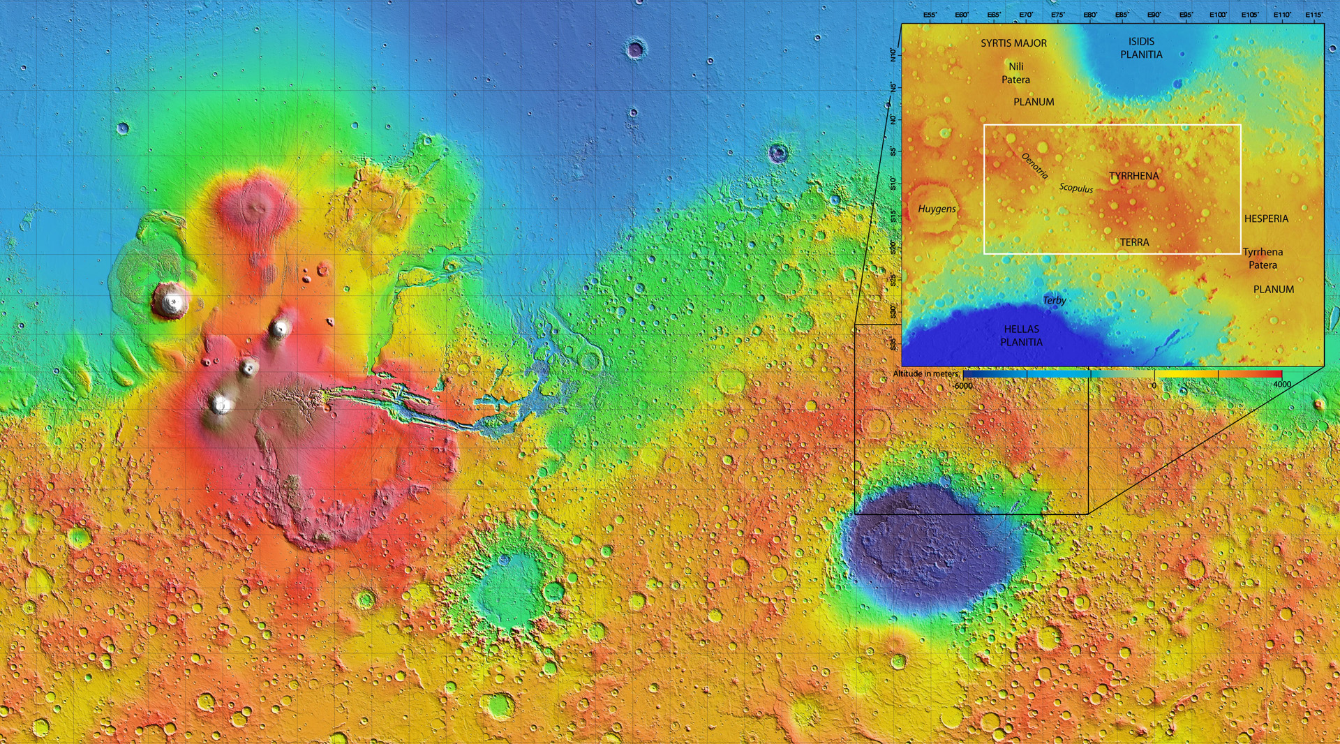
 The 1000 x 2000 km area region of Tyrrhena Terra (outlined by the white box in the inset) sits between two regions of low altitude – Hellas Planitia and Isidis Planitia – in Mars’ southern hemisphere, as shown in this global topography map. Hydrated minerals were found in 175 locations associated with impact craters in Tyrrhena Terra, such as inside the walls of craters, along crater rims, or in material excavated by the impact. Analysis suggests that these minerals were formed in the presence of water that persisted at depth for an extended period of time. 
Credits: NASA/MOLA Science Team /D. Loizeau et al.

 “The large range of crater sizes studied, from less than 1 km to 84 km wide, indicates that these hydrated silicates were excavated from depths of tens of metres to kilometres,” says Damien Loizeau, lead author of the study.
“The composition of the rocks is such that underground water must have been present here for a long period of time in order to have altered their chemistry.”
While the material excavated by impacts appears to have been in close contact with water, there is little evidence for rocks on the surface lying between the craters in Tyrrhena Terra having been altered by water.
“Water circulation occurred several kilometres deep in the crust some 3.7 billion years ago, before the majority of craters formed in this region,” says co-author Nicolas Mangold.
“The water generated a diverse range of chemical changes in the rocks that reflect low temperatures near the surface to high temperatures at depth, but without a direct relationship to the surface conditions at that time.”
By comparison, Mawrth Vallis, one of the largest identified clay-rich regions of Mars, displays a more uniform aqueous mineralogy that indicates a closer link with surface processes.
“The role of liquid water on Mars is of great importance for its habitability and this study using Mars Express describes a very large zone where groundwater was present for a long time,” says Olivier Witasse, ESA’s Mars Express project scientist.
  ESA
 Guillermo Gonzalo Sánchez Achutegui
 ayabaca@gmail.com
 ayabaca@hotmail.com
 ayabaca@yahoo.com
 Inscríbete en el Foro del blog y participa : A Vuelo De Un Quinde - El Foro!

domingo, 6 de mayo de 2012

Astronomía: Nuevos indicios de erosión hídrica en Marte

Hola amigos: A VUELO DE UN QUINDE EL BLOG., La sonda Mars Express de la ESA nos muestra esta semana una región del Planeta Rojo que parece haber sido esculpida por el flujo del agua. Estas imágenes se suman a la larga lista de pruebas de la existencia de grandes masas de agua en la superficie de Marte en algún momento de su pasado.


Download:
 HI-RES JPEG (Size: 324 kb)
  HI-RES TIFF (Size: 61 500 kb)

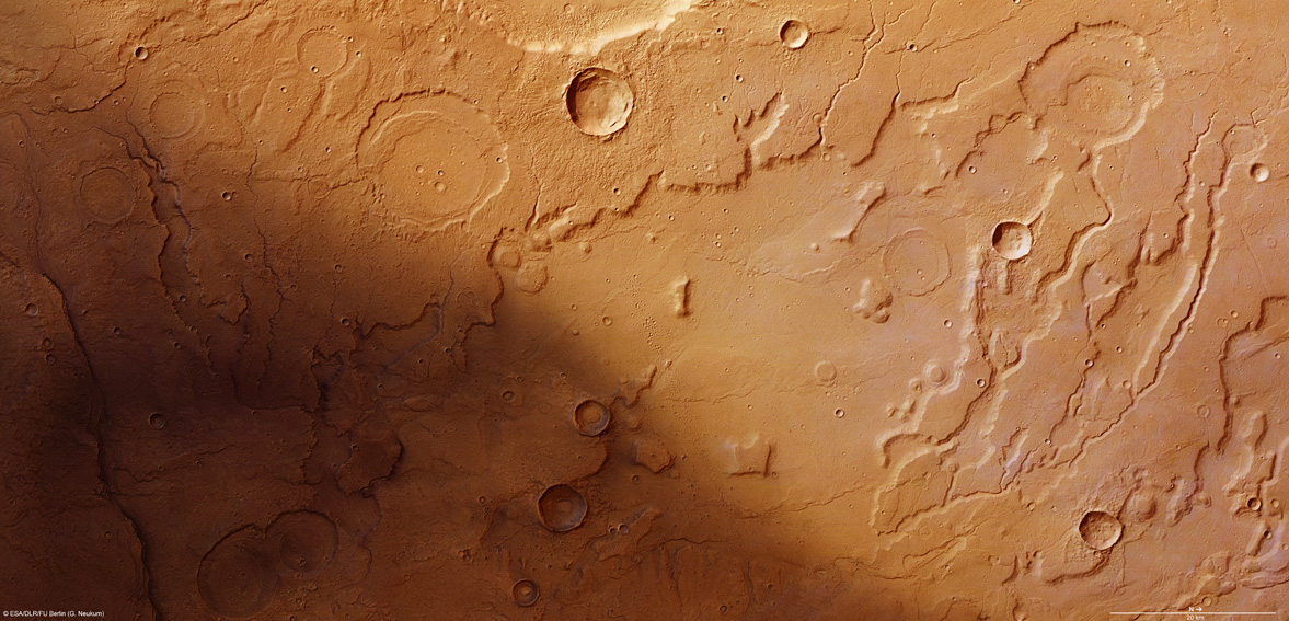
The transition between Acidalia Planitia and Tempe Terra from the Mars Express High-Resolution Stereo Camera (HRSC) nadir and colour channels, combined to form a natural colour view of the region. Centred at around 37°N and 306°E, this image has a ground resolution of about 15 m per pixel. The dendritic channels found commonly on Earth have analogues in the far-flung reaches of the Solar System. Here, it is strong evidence for the existence of water in Mars’ past.
Credits: ESA/DLR/FU Berlin (G. Neukum)


Download:
 HI-RES JPEG (Size: 500 kb)
 HI-RES TIFF (Size: 3180 kb)


The transition between Acidalia Planitia and Tempe Terra is shown here in a computer-generated perspective view. The image was created using data obtained from the High-Resolution Stereo Camera (HRSC) on ESA’s Mars Express spacecraft. Centred at around 37°N and 306°E, this image has a ground resolution of about 15 m per pixel. The foreground craters are believed to come from a younger phase in Mars history, evidenced by a lack of erosion and infilling seen in the background craters, which are believed to have once held liquid water.
Credits: ESA/DLR/FU Berlin (G. Neukum)

Download:
 HI-RES JPEG (Size: 577 kb)
  HI-RES TIFF (Size: 44 444 kb)


The transition between Acidalia Planitia and Tempe Terra was imaged during orbit 9534 of Mars Express by the HRSC. Centred at around 37°N and 306°E, this 3D image has a ground resolution of about 15 m per pixel. Data from HRSC’s nadir channel and one stereo channel are combined to produce this 3D image, which can be viewed using stereoscopic glasses, with red–green or red–blue filters. This anaglyph image clearly shows the difference between the youngest and oldest craters, with the younger craters having a deep interior and sharp slopes, whereas the older craters show a filled interior and shallow slope.
Credits: ESA/DLR/FU Berlin (G. Neukum)


Download:
 HI-RES JPEG (Size: 511 kb)
 HI-RES TIFF (Size: 2870 kb)


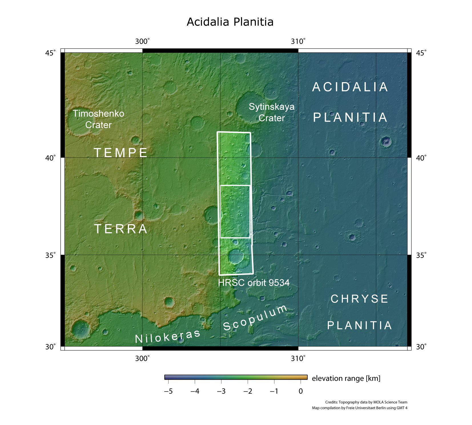
Acidalia Planitia in a broader context. Here we see Acidalia Planitia in a wider context, and the interface between it and Tempe Terra. The smaller rectangle shows the region covered in this Mars Express HRSC image release.
Credits: NASA MGS MOLA Science Team


Download:
 HI-RES JPEG (Size: 356 kb)
  HI-RES TIFF (Size: 75 300 kb)


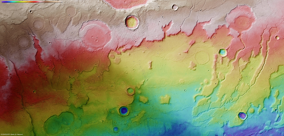
The transition between Acidalia Planitia and Tempe Terra in a colour-coded plan view based on a digital terrain model of the region, from which the topography of the landscape can be derived. Note the variance in depth between the older craters at the top of the image and the younger smaller craters to the lower part. Centred at around 37°N and 306°E, this image has a ground resolution of about 15 m per pixel. The upper craters are believed to have once held liquid water and have been subsequently filled in by sediments.
Credits: ESA/DLR/FU Berlin (G. Neukum)


Nuevos indicios de erosión hídrica en Marte:
La sonda Mars Express de la ESA nos muestra esta semana una región del Planeta Rojo que parece haber sido esculpida por el flujo del agua. Estas imágenes se suman a la larga lista de pruebas de la existencia de grandes masas de agua en la superficie de Marte en algún momento de su pasado.

El 21 de junio del año pasado, Mars Express apuntó su cámara estéreo de alta resolución (HRSC) hacia la parte occidental de Acidalia Planitia, una gigantesca cuenca en las tierras bajas del norte de Marte, cerca de dónde se encuentra con Tempe Terra, un terreno más elevado y de mayor antigüedad.
Acidalia Planitia es una región tan extensa que se puede observar desde la Tierra con un telescopio amateur.
El famoso astrónomo Giovanni Schiaparelli bautizó a esta gran mancha oscura con el nombre de la mítica fuente Acidalia, en Beocia, donde según la mitología griega se bañaba Venus con las tres Gracias.  
 Estas imágenes abarcan parte del límite occidental de la región. En ellas se pueden apreciar sutiles patrones de drenaje ‘dendríticos’ partiendo de los numerosos valles que descienden por la ladera de Tempe Terra.
La palabra ‘dendrítico’ procede del griego δένδρον, que significa ‘árbol’. Se piensa que los canales que se pueden ver en estas imágenes fueron formados por la escorrentía de aguas pluviales o de aguas procedentes del deshielo, en algún momento del pasado de Marte.
La profundidad de estos valles, unida al hecho de que presentan muy pocos afluentes en su curso bajo, sugiere que la región se transformó a través de un mecanismo de erosión conocido como ‘minado’ o ‘socavación’, que es el que tiene lugar cuando el agua arrastra los materiales más blandos de la base de un acantilado.
El proceso de socavación retira el apoyo de las capas superiores, formadas por rocas más duras, que terminan resquebrajándose en grandes bloques que se desprenden por la ladera del desnivel.
De esta forma, el proceso de erosión va avanzando hacia el curso superior del cauce, haciéndolo más profundo, de forma similar a lo que ocurre en la Meseta del Colorado aquí en la Tierra.
La esquina inferior izquierda de la imagen parece estar a la sombra, pero este oscurecimiento se debe en realidad a los distintos materiales que conforman la superficie: la parte izquierda está cubierta por arena oscura, probablemente de origen volcánico, mientras que la derecha está cubierta por una capa de polvo, más brillante.
En estas imágenes también se pueden distinguir varias fallas en la corteza marciana, extendiéndose hacia la región de Idaeus Fossae. Se piensa que estas formaciones pudieron jugar un papel fundamental a la hora de traer agua a la región. Al formarse, pudieron haber dejado al descubierto acuíferos subterráneos, que fluirían creando lagos en los cráteres de sus alrededores.
Los científicos están especialmente interesados en lo que parecen ser sedimentos cubriendo el fondo de algunos de los cráteres más antiguos y erosionados, ya que podrían ser nuevas pruebas de la existencia de agua líquida en la superficie de Marte en algún momento de su historia.
En algunos casos los valles arrancan del borde de un cráter, lo que sugiere que en algún momento el agua se desbordó y fluyó hacia los terrenos colindantes.
En el centro de la imagen se pueden distinguir cráteres más jóvenes, que se caracterizan por estar menos erosionados y por encontrarse sobre estructuras más antiguas.
 Estas imágenes de Mars Express aportan nuevas pruebas de la existencia de agua en la superficie de Marte en algún momento de su pasado, y ayudarán a descifrar cómo el agua surgió, fluyó, erosionó y se retiró de la superficie del Planeta Rojo en distintas épocas de su historia.
ESA.
Guillermo Gonzalo Sánchez Achutegui
ayabaca@gmail.com
ayabaca@hotmail.com
ayabaca@yahoo.com
Inscríbete en el Foro del blog y participa : A Vuelo De Un Quinde - El Foro!

jueves, 9 de febrero de 2012

ASTRONOMY: Mars Express reveals wind-blown deposits on Mars

Hi My Friends: A VUELO DE UN QUINDE EL BLOG., New images from ESA’s Mars Express show the Syrtis Major region on Mars. Once thought to be a sea of water, the region is now known to be a volcanic province dating back billions of years.A wider contextual image of Syrtis Major. The smaller rectangle shows the region covered in this Mars Express HRSC image release. Credits: NASA MGS MOLA Science Team


HI-RES TIFF (Size: 62 224 kb)
A wider contextual image of Syrtis Major. The smaller rectangle shows the region covered in this Mars Express HRSC image release.

Credits: NASA MGS MOLA Science Team

Syrtis Major, discovered in 1659 by Christaan Huygens, is a volcanic province on Mars. The image is centred on approximately 16°N/73°E. The High-Resolution Stereo Camera (HRSC) on ESA’s Mars Express collected the data for this image on 8 June 2011 during orbit 9487. The image has a ground resolution of approximately 19 m per pixel. The image size is approximately 90x180 km.

Credits: ESA/DLR/FU Berlin (G. Neukum)Syrtis Major is a volcanic province on Mars. This image from the High-Resolution Stereo Camera on ESA’s Mars Express orbiter shows lava flows in box 1. Filled craters and partly filled craters can be seen in box 2. The prevailing wind direction can be judged from the dispersal of the lighter-toned material. The smaller craters illustrate this clearly. The largest crater in the picture, highlighted in box 3, has a small central peak and contains a small dune field of darker-toned dunes. ESA’s Mars Express collected the data for this image on 8 June 2011 during orbit 9487. The image has a ground resolution of approximately 19 m per pixel.
Credits: ESA/DLR/FU Berlin (G. Neukum)


Syrtis Major, discovered in 1659 by Christaan Huygens, is a volcanic province on Mars. The image is centred on approximately 16°N/73°E. The image was created using a Digital Terrain Model (DTM) obtained from the High-Resolution Stereo Camera on ESA’s Mars Express spacecraft. Elevation data from the DTM is colour coded: purple indicates the lowest-lying regions and grey the highest. The scale is in metres. The data for these images were collected on 8 June 2011 during orbit 9487. The images have a ground resolution of approximately 19 m per pixel. Credits: ESA/DLR/FU Berlin (G. Neukum)
Syrtis Major, discovered in 1659 by Christaan Huygens, is a volcanic province on Mars. The image is centred on approximately 16°N/73°E. The High-Resolution Stereo Camera on ESA’s Mars Express collected the data for these images on 8 June 2011 during orbit 9487. The images have a ground resolution of approximately 19 m per pixel. It was derived from the nadir channel, which provides the highest detail of all the channels. Credits: ESA/DLR/FU Berlin (G. Neukum
Syrtis Major, discovered in 1659 by Christaan Huygens, is a volcanic province on Mars. The image is centred on approximately 16°N/73°E. The High-Resolution Stereo Camera on ESA’s Mars Express collected the data for these images on 8 June 2011 during orbit 9487. The images have a ground resolution of approximately 19 m per pixel. This perspective view has been calculated from the Digital Terrain Model derived from the stereo channels. Some ancient lava flow fronts are seen in the foreground and a lighter-toned butte is emerging on the right. Credits: ESA/DLR/FU Berlin (G. Neukum)
Syrtis Major, discovered in 1659 by Christaan Huygens, is a volcanic province on Mars. The image is centred on approximately 16°N/73°E. The High-Resolution Stereo Camera on ESA’s Mars Express collected the data for these images on 8 June 2011 during orbit 9487. The image combines data from the nadir channel and one stereo channel to produce this 3D image. Stereoscopic glasses are required to see the 3D effect. Credits: ESA/DLR/FU Berlin (G. Neukum)
New images from ESA’s Mars Express show the Syrtis Major region on Mars. Once thought to be a sea of water, the region is now known to be a volcanic province dating back billions of years. Syrtis Major can be spotted from Earth even with relatively small telescopes – the near-circular dark area on the planet stretches over 1300 x 1500 km.
Christiaan Huygens discovered this area in 1659 and by repeated observations he used it to time the length of day on Mars.
Early ideas held that it was a sea with a water level that rose and fell, causing the markings to change.
Now, however, we know that the region is volcanic in origin, devoid of water and that the changes in its shape are due to dust and sand being blown around in the wind.
Newly released images of a part of Syrtis Major seen from ESA’s Mars Express orbiter show lava flows that flooded the older highland material, leaving behind buttes – isolated hills with steep sides that were too high to be affected.
They can be identified by their lighter colours and their eroded state, and some even show ancient valleys on their flanks.
Individual lava flows, filled craters and partly-filled craters can be made out in the images. The prevailing wind direction can be seen from the dispersal of the lighter-toned dust and darker-toned sand in and around the craters and buttes. The smaller craters illustrate this clearly.
The largest crater in the pictures has a small central peak and contains a small dune field of darker-toned dunes to the east of its floor.
The number and size of craters can be used to date surfaces in the Solar System because craters slowly accumulate as impacts occur over time. This information can be used to date the volcanic province and suggests an age of over 3 billion years. ESA.
Guillermo Gonzalo Sánchez Achutegui
ayabaca@gmail.com
ayabaca@hotmail.com
ayabaca@yahoo.com
Inscríbete en el Foro del blog y participa : A Vuelo De Un Quinde - El Foro!

Mi lista de blogs