Mostrando entradas con la etiqueta European Space Agency. Mostrar todas las entradas

martes, 13 de agosto de 2013

ESA - First morning at Concordia


Daylight is not far away

First morning at Concordia

9 August 2013
After three months of continuous night, morning will break on Saturday at the Concordia research station in Antarctica.
The Sun last set there in May and since then, the crew have watched for the faintest glow on the horizon that hinted at the position of the Sun and that separates nighttime from day. This glow dwindled into complete darkness at deepest point of winter in mid-June, and it has been gradually reappearing, slowly but steadily building up to the first real sunrise.
According previous crews, the difference between the bright glow and direct sunlight is huge; for the current crew, Saturday’s daybreak will be the most magnificent sunrise ever, revealing once more the icy panorama around their station.

Extreme conditions

The darkness of winter in polar regions is well known by people living in the far north. But the isolation and solitude of winter on the research station – located on the most distant and climatically challenging continent – is extreme. Spending a year in Antarctica and experiencing the long, cold and dark winter is comparable to carrying out space missions in many ways, which is why ESA takes part in activities at the Concordia station.
For ex
Concordia in the dark
ample, bright light lamps are needed to regulate the crew’s body clocks at the station, and some crew members resort to medication to adjust their body clocks after they fall into an effect called ‘free-run’, when the actual time and their body clocks differ too much, and their bodies fail to regulate sleep. In space, the problem is actually the reverse: the astronauts on the Space Station experience 16 sunrises and sunsets a day, which is also severely disturbing.
The crew dynamics in a confined space under constant pressure is also like being on the Space Station. And after months of isolation, the Antarctica ‘hivernauts’ and International Space Station astronauts face the same issues: they have all but forgotten what it is like to see other people around, to smell the fresh scents of nature and to be outside without special protective clothing.
Concordia’s research doctors are sponsored by ESA, and this year the Greek Evangelos Kaimakamis has this role. In addition, Frenchman Olivier Delanoe is working with the grey water recycling system of Concordia, which is based on ESA developments for life support in spacecraft.
Evangelos and Concordia’s Italian technician Antonio Litterio have been blogging during the winter, and you can read about their experiences on the ESA Concordia blog.

Towards nightless night

 
After the first morni


It's dark and cold outside!
ng, the days will grow longer and longer until by December, the Sun will stay above the horizon for 24 hours a day. Then the base will be busy with visiting researchers and preparations for the next long winter. By then, the temperature will have risen to comfortable –25°C – a warm summer’s day by Concordia’s standards.
For the crew who live through the winter at the base, the arrival of the Sun is an important milestone, but the following months will be hard. They will have lot to do, for example cleaning up their base and preparing the summer camp. Even though the first plane does not arrive until November, opening officially the summer season and linking them to the outside world again, now it will be like the last leg of an endurance race: the worst is over.
ESA
Guillermo Gonzalo Sánchez Achutegui

domingo, 7 de julio de 2013

NASA - Cassini Probe to Take Photo of Earth From Deep Space


Wave at Saturn banner art

Wave at Saturn -- Introduction
Cassini is Going to Compose a Special Portrait of Saturn … and You!
By Linda Spilker
June 18, 2013
One of the most exciting Cassini events in 2013 will be the unusual opportunity on July 19 to image the whole Saturn system as it is backlit by the sun. With Saturn covering the harsh light of the sun, we will be gathering unique ring science and also catching a glimpse of our very own home planet.
A computer simulated  view of Saturn from Cassini on July 19.
This simulated view from NASA's Cassini spacecraft shows the expected positions of Saturn and Earth on July 19, 2013, around the time Cassini will take Earth's picture. Cassini will be about 898 million miles (1.44 billion kilometers) away from Earth at the time. That distance is nearly 10 times the distance from the sun to Earth. Image credit: NASA/JPL-Caltech
 
The main science goal for the mosaic we are making of the Saturn system is to look at the more diffuse rings that encircle Saturn and check for change over time. A previous mosaic of the Saturn system Cassini made in 2006 revealed that the dusty E ring, which is fed by the water-ice plume of the moon Enceladus, had unexpectedly large variations in brightness and color around its orbit. We'll want to see how that looks seven Earth years and a Saturnian season later, giving us clues to the forces at work in the Saturn system. We'll do this analysis by collecting data from our visual and infrared mapping spectrometer, composite infrared mapping spectrometer and ultraviolet imaging spectrograph in addition to the imaging cameras.
But one of the best parts of the mosaic we're making on July 19 is that we'll be able to take a picture of Earth – and all of you -- from about 898 million miles (1.44 billion kilometers) away. The Earth will appear to be just a pixel, but you can see in this simulated close-up what parts of it will be illuminated.
A computer simulated,  close-up view of Earth from Cassini on July 19.
North America and part of the Atlantic Ocean are expected to be illuminated when NASA's Cassini spacecraft takes a snapshot of Earth on July 19, 2013. This view is a close-up simulation. Image credit: NASA/JPL-Caltech
 
Opportunities to image Earth from the outer solar system are few and far between and special care must be taken so we don't blind our cameras by looking in the direction of the sun, where Earth is. There have been only two images of Earth from the outer solar system in all the time humankind has been venturing out into space. The first and most distant was one was taken 23 years ago by NASA's Voyager 1 spacecraft from 4 billion miles (6 billion kilometers away), showing
The other opportunity was 
We think Cassini's July image is a special opportunity for Earthlings to wave at our photographer in the Saturn system and learn more about my favorite planet, its rings and moons. We hope you'll go outside, look in the direction of Saturn and send us pictures of yourselves waving. You can share your pictures by joining our Flickr group Wave at Saturn, adding them to our Wave at Saturn Facebook event page or tagging pictures on Twitter #waveatsaturn. We hope to make a special collage of all these images if we get enough of them.
The Cassini portrait session of Earth will last about 15 minutes from 2:27 to 2:42 p.m. PDT (21:27 to 21:42 UTC).
Another blog post by Jane Houston Jones, provides more information about where to look in the sky.

Linda Spilker is the Cassini project scientist, based at NASA's Jet Propulsion Laboratory, Pasadena, Calif.


  • Blend space exploration with reading and writing -- Reading, Writing & Rings!
  • Cassini Scientist for a Day -- Students get involved
  • Cassini Raw Images

Cassini Probe to Take Photo of Earth From Deep Space
WASHINGTON - NASA's Cassini spacecraft, now exploring Saturn, will take a picture of our home planet from a distance of hundreds of millions of miles on July 19. NASA is inviting the public to help acknowledge the historic interplanetary portrait as it is being taken.

Earth will appear as a small, pale blue dot between the rings of Saturn in the image, which will be part of a mosaic, or multi-image portrait, of the Saturn system Cassini is composing.

"While Earth will be only about a pixel in size from Cassini's vantage point 898 million (1.44 billion kilometers) away, the team is looking forward to giving the world a chance to see what their home looks like from Saturn," said Linda Spilker, Cassini project scientist at NASA's Jet Propulsion Laboratory (JPL) in Pasadena, Calif. "We hope you'll join us in waving at Saturn from Earth, so we can commemorate this special opportunity."

Cassini will start obtaining the Earth part of the mosaic at 5:27 p.m. EDT (2:27 p.m. PDT or 21:27 UTC) and end about 15 minutes later, all while Saturn is eclipsing the sun from Cassini's point of view. The spacecraft's unique vantage point in Saturn's shadow will provide a special scientific opportunity to look at the planet's rings. At the time of the photo, North America and part of the Atlantic Ocean will be in sunlight.

Unlike two previous Cassini eclipse mosaics of the Saturn system in 2006, which captured Earth, and another in 2012, the July 19 image will be the first to capture the Saturn system with Earth in natural color, as human eyes would see it. It also will be the first to capture Earth and its moon with Cassini's highest-resolution camera. The probe's position will allow it to turn its cameras in the direction of the sun, where Earth will be, without damaging the spacecraft's sensitive detectors.

"Ever since we caught sight of the Earth among the rings of Saturn in September 2006 in a mosaic that has become one of Cassini's most beloved images, I have wanted to do it all over again, only better," said Carolyn Porco, Cassini imaging team lead at the Space Science Institute in Boulder, Colo. "This time, I wanted to turn the entire event into an opportunity for everyone around the globe to savor the uniqueness of our planet and the preciousness of the life on it."

Porco and her imaging team associates examined Cassini's planned flight path for the remainder of its Saturn mission in search of a time when Earth would not be obstructed by Saturn or its rings. Working with other Cassini team members, they found the July 19 opportunity would permit the spacecraft to spend time in Saturn's shadow to duplicate the views from earlier in the mission to collect both visible and infrared imagery of the planet and its ring system.

"Looking back towards the sun through the rings highlights the tiniest of ring particles, whose width is comparable to the thickness of hair and which are difficult to see from ground-based telescopes," said Matt Hedman, a Cassini science team member based at Cornell University in Ithaca, N.Y., and a member of the rings working group. "We're particularly interested in seeing the structures within Saturn's dusty E ring, which is sculpted by the activity of the geysers on the moon Enceladus, Saturn's magnetic field and even solar radiation pressure."

This latest image will continue a NASA legacy of space-based images of our fragile home, including the 1968 "Earthrise" image taken by the Apollo 8 moon mission from about 240,000 miles (380,000 kilometers) away and the 1990 "Pale Blue Dot" image taken by Voyager 1 from about 4 billion miles (6 billion kilometers) away.

The Cassini-Huygens mission is a cooperative project of NASA, the European Space Agency and the Italian Space Agency. JPL manages the Cassini-Huygens mission for NASA's Science Mission Directorate in Washington, and designed, developed and assembled the Cassini orbiter and its two onboard cameras. The imaging team consists of scientists from the United States, the United Kingdom, France and Germany. The imaging operations center is based at the Space Science Institute in Boulder, Colo.

To learn more about the public outreach activities associated with the taking of the image, visit:
 

For more information about Cassini, visit
 
 
 NASA
Guillermo Gonzalo Sánchez Achutegui
ayabaca@gmail.com
ayabaca@hotmail.com
ayabaca@yahoo.com
Inscríbete en el Foro del blog y participa : A Vuelo De Un Quinde - El Foro!

martes, 21 de agosto de 2012

Astronomy: Fourth Galileo satellite reaches French Guiana launch site

Hi My Friends: A VUELO DE UN QUINDE EL BLOG., The next two Galileo satellites are now in place at Europe’s Spaceport in French Guiana, being prepared for their shared launch this autumn.
The fourth Galileo flight model satellite being unloaded at Cayenne Airport in French Guiana on 17 August 2012 
Credits: ESA/EADS Astrium - Raoul Kieffer

The next two Galileo satellites are now in place at Europe’s Spaceport in French Guiana, being prepared for their shared launch this autumn.

The fourth Galileo satellite flight model arrived at Cayenne Airport in French Guiana on Friday 17 August, flown from the Thales Alenia Space facility in Rome aboard an Ilyushin aircraft. Cocooned inside a protective air-conditioned container, the satellite was then transported to the preparation facility at the Guiana Space Centre to join the third Galileo satellite, which arrived there 10 days earlier.   
 The fourth Galileo flight model satellite being unloaded from its Ilyushin aircraft at Cayenne Airport in French Guiana on 17 August 2012 
Credits: ESA/EADS Astrium - Raoul Kieffer

 These third and fourth Galileo ‘In-Orbit Validation’ (IOV) satellites are due to be launched aboard a Soyuz ST-B vehicle in October. These new satellites will join the first two Galileo satellites – launched last year – in medium Earth orbit at 23 222 km. This will mark a significant step in Europe’s programme because it will complete the deployment of infrastructure required for the IOV phase and will allow for the first time a computation of on-ground position based solely on Galileo satellites.

Download:
 The four Galileo In-Orbit Validation satellites in their orbits 
Credits: ESA - P. Carril

 The IOV phase is being followed by the deployment of additional satellites and ground segment as required to achieve the ‘Full Operational Capability’, leading to provision of services.
The first 22 of these FOC satellites are currently being built by OHB in Germany, responsible for the platforms and final satellite integration, and UK-based Surrey Satellite Technology Ltd, producing the payloads.
The first four Galileo IOV satellites have been built by a consortium led by EADS Astrium, Germany, with Astrium producing the platforms and Astrium UK responsible for the payloads.
 ESA
Guillermo Gonzalo Sánchez Achutegui
ayabaca@gmail.com
ayabaca@hotmail.com
ayabaca@yahoo.com
 Inscríbete en el Foro del blog y participa : A Vuelo De Un Quinde - El Foro!

Astronomy: Fantastic Phobos

Hi My Friends: A VUELO DE UN QUINDE EL BLOG., Some 135 years after its discovery, Mars’ largest moon Phobos is seen in fantastic detail – and in 3D – in an image taken by ESA’s Mars Express spacecraft as it passed just 100 km by.

Download:
Mars Express HRSC (High Resolution Stereo Camera) image of Phobos taken on 9 January 2011 at a distance of 100 km with a resolution of 8.1 m/pixel. Use red-blue glasses to fully appreciate this image.
Phobos is approximately 27 × 22 × 18 km and orbits Mars at a distance of 6000 km above the planet’s surface, or 9400 km from the centre of the planet. 
Credits: ESA/DLR/FU Berlin (G. Neukum)

 Some 135 years after its discovery, Mars’ largest moon Phobos is seen in fantastic detail – and in 3D – in an image taken by ESA’s Mars Express spacecraft as it passed just 100 km by.
This view is much different to the faint object that astronomer Asaph Hall would have just been able to make out as he observed the Red Planet through the United States Naval Observatory’s 66 cm telescope in 1877. Through this telescope he discovered Mars’ smaller, outermost moon Deimos on 12 August and the larger, innermost moon Phobos on 18 August.
More than a century later later, spacecraft in orbit around Mars are studying Phobos in unprecedented detail.
In this image, a bite-sized chunk appears to be missing from the right edge of the irregular shaped moon – this is a side-on view of the rim of large impact crater Stickney, so-called after the maiden name of the discoverer’s wife.
Families of grooves appear to emanate from Stickney, carving channels across the approximately 27 km length of the moon. Initially thought to be associated with the Stickney impact crater, one recent theory suggests that they were instead formed when Phobos passed through debris clouds thrown up from the surface of Mars by asteroid impacts onto the planet’s surface.
Orbiting Mars at just 6000 km from the planet’s surface, it is closer to its parent planet than any other known moon in our Solar System. The moon’s proximity means that it hurtles around Mars faster than the planet rotates: for an observer on the surface of Mars, Phobos would appear to rise and set twice a day.
The moon’s orbit is decreasing and in some 50 million years time it will likely break up to form a debris ring around Mars, before colliding with the planet’s surface. 
 ESA
Guillermo Gonzalo Sánchez Achutegui
ayabaca@gmail.com
ayabaca@hotmail.com
ayabaca@yahoo.com
 Inscríbete en el Foro del blog y participa : A Vuelo De Un Quinde - El Foro!

lunes, 13 de agosto de 2012

Olympic Games 2012: Proba-1 microsat snaps Olympic neighbourhood

Hi My Friends: A VUELO DE UN QUINDE EL BLOG., This Olympics has been watched from all over the world – and beyond. Benefiting from a cloudless sky, this view of London’s Olympic Park was captured by the smallest imager aboard ESA’s smallest mission: the High Resolution Camera on the Proba-1 microsatellite.
 Great Britain's gold medalists stand on the roof of Team GB House to celebrate on the last day of the Olympics. Photograph: Georgie Gillard/NOPP
 Proba-1 HRC image of London Olympic Park neighbourhood
Download:
 The London Olympic Park including Olympic Stadium is visible towards the base of this Proba-1 High Resolution Camera image of East London, acquired on 11 August 2012. The 5-m resolution black and white image covers 25 sq km. 
Credits: ESA
 This Olympics has been watched from all over the world – and beyond. Benefiting from a cloudless sky, this view of London’s Olympic Park was captured by the smallest imager aboard ESA’s smallest mission: the High Resolution Camera on the Proba-1 microsatellite.

The Olympic Park, dominated by the circular Olympic Stadium, is visible towards the base of this 5 m-resolution image, with Victoria Park to its west and Hackney Marsh to the northwest.
This image was acquired by the High Resolution Camera (HRC). This black and white digital camera incorporates a Cassegrain telescope miniaturised to fit aboard Proba-1. Orbiting at 720 km altitude, the entire satellite’s volume is less than a cubic metre.
HRC operates alongside Proba-1’s larger CHRIS (Compact High Resolution Imaging Spectrometer) hyperspectral imager, which returns 15 m-resolution scenes across a programmable selection of up to 62 spectral bands, from a variety of viewing angles. This HRC image was acquired on 11 August. 

 Marking 10 years in orbit in October 2011, Proba-1, ESA's first Project for On Board Autonomy micro-satellite, demonstrates the potential and feasibility of small satellites for advanced scientific and Earth observation missions 
Credits: ESA

 About Proba-1

Operational for more than a decade, Proba-1 was the first in ESA’s series of satellites aimed at providing in-orbit testing of new space technologies. Smaller than a cubic metre, Proba-1’s many experiments include the compact HRC, acquiring monochromatic images with an area of 25 sq km.
Proba stands for ‘Project for Onboard Autonomy’ – both cameras are largely autonomous. Controllers at ESA’s Redu station in Belgium send up the location to be imaged – latitude, longitude and altitude – then the satellite itself does the rest, lining up its instruments with its target on the ground.
 

Proba-1 was launched back in October 2001 as an experimental mission but is still going strong, having since been reassigned to ESA’s Earth observation team. This year a software fix returned its radiation-damaged star trackers to full operations.
In November 2009 Proba-1 was joined in orbit by Proba-2, focused on solar monitoring. Proba-V, to monitor global vegetation, is due to launch next year.
 ESA
Guillermo Gonzalo Sánchez Achutegui
ayabaca@gmail.com
ayabaca@hotmail.com
ayabaca@yahoo.com
 Inscríbete en el Foro del blog y participa : A Vuelo De Un Quinde - El Foro!

lunes, 6 de agosto de 2012

MARS: ESA spacecraft records crucial NASA signals from Mars

Hi My Friends: A VUELO DE UN QUINDE EL BLOG., This morning at 7:14 CEST, ESA’s Mars Express acquired signals from NASA’s Mars Science Laboratory as it delivered the car-sized Curiosity rover onto the Red planet’s surface. ESA’s New Norcia tracking station also picked up signals directly from the NASA mission, 248 million km away at Mars.
 Curiosity's first view of Mars 
Credits: NASA

The open-loop recording of radio Doppler and signal spectrum transmitted by the NASA mission were stored on Mars Express and then downloaded to Earth starting at 08:15 CEST.
Animation: Mars Express tracks NASA MSL
 The recorded signals were transferred to NASA’s Jet Propulsion Laboratory, Pasadena, California, for analysis immediately upon receipt at ESOC. Similar direct-to-Earth recordings made at ESA’s New Norcia ground station in Australia were also sent to NASA.  

Curiosity’s descent was also tracked by NASA’s own Odyssey and Mars Reconnaissance Orbiter (MRO) spacecraft; confirmation of touchdown was provided by Odyssey directly to NASA at 07:31 CEST.
 

ESA welcomes new friend at Mars

"Congratulations to our NASA colleagues on a hugely successful landing,” said Paolo Ferri, ESA’s Head of Solar and Planetary Mission Operations. “The Mars Express team welcomes a new friend in the neighbourhood."
Mars Express picked up MSL signals about 10 minutes before it entered the atmosphere, travelling at 21 000 km/h, for its critical descent and landing phase.
 
Download:
 ESOC serves as the Operations Control Centre for ESA missions, and hosts our Main Control Room (shown here), combined Dedicated Control Rooms for specific missions and the ESTRACK Control Centre - which manages our worldwide ground tracking stations. ESOC also hosts facilities for satellite communications, navigation, networks and other special functions.
Credits: ESA - J. Mai

“We tracked MSL for about 28 minutes then lost contact as expected just a few moments before Curiosity’s touchdown in Gale Crater,” said Michel Denis, Mars Express Spacecraft Operations Manager.

“NASA now have this valuable data and everyone here is delighted to have helped support Curiosity’s arrival at Mars.”
 

The signal recordings made by Mars Express and New Norcia station include information on MSL’s velocity and direction. They record the sequential critical events during descent, including parachute deployment, heat shield separation and rover separation.
They will prove valuable to scientists as they reconstruct MSL’s descent profile, helping to improve and refine models of the martian atmosphere and assess landing accuracy.
The signals recorded by Mars Express will be automatically downloaded two more times later today via New Norcia and ESA’s Cebreros station, in Spain, to ensure redundancy.   
  ESA’s first step in continuing Curiosity support
 New Norcia antenna
Credits: ESA
ESA’s first step in continuing Curiosity support

In the coming weeks, Mars Express and the operations team at ESOC will perform several data relay overflights during the first phases of Curiosity’s mission on the surface of Mars.
Then, ESA will offer a standby capability to provide dedicated support at short notice, if requested by NASA, by relaying data from Curiosity to Earth.
 

This could become necessary if Odyssey or MRO were to experience any technical problems, for example.
ESA’s tracking station network can support NASA missions, due in part to long-standing technical and operational cooperation between the two agencies.
“Supporting Curiosity is an excellent example of inter-agency cooperation not only on Earth but also in deep space,” said Manfred Warhaut, ESA’s Head of Mission Operations.
“No one likes going to Mars on their own; it takes cooperation and partnership to reduce risk and boost scientific return on investment.”
ESA


 Guillermo Gonzalo Sánchez Achutegui


Inscríbete en el Foro del blog y participa : A Vuelo De Un Quinde - El Foro!

sábado, 4 de agosto de 2012

MARTE: Mars Express marca el lugar donde aterrizará Curiosity

Hola amigos: A VUELO DE UN QUINDE EL BLOG., Al igual que en el mapa de un tesoro, en el que la ‘X’ marca el lugar donde se esconde un cofre enterrado, el rover Curiosity de la NASA ha puesto rumbo hacia su propia ‘X’ en el interior del cráter Gale, donde tratará de encontrar indicios de la existencia de agua – y puede que de vida – en el pasado del Planeta Rojo.

Download:
Gale Crater is 154 km wide and is located at latitude 5.4 degrees south and longitude 137.9 degrees east. This image, taken by the High Resolution Stereo Camera (HRSC) of Mars Express, has a resolution of 100 metres per pixel. It is colour-coded based on a digital terrain model derived from stereo image data. 
Credits: ESA/DLR/FU Berlin (G. Neukum).
Al igual que en el mapa de un tesoro, en el que la ‘X’ marca el lugar donde se esconde un cofre enterrado, el rover Curiosity de la NASA ha puesto rumbo hacia su propia ‘X’ en el interior del cráter Gale, donde tratará de encontrar indicios de la existencia de agua – y puede que de vida – en el pasado del Planeta Rojo.

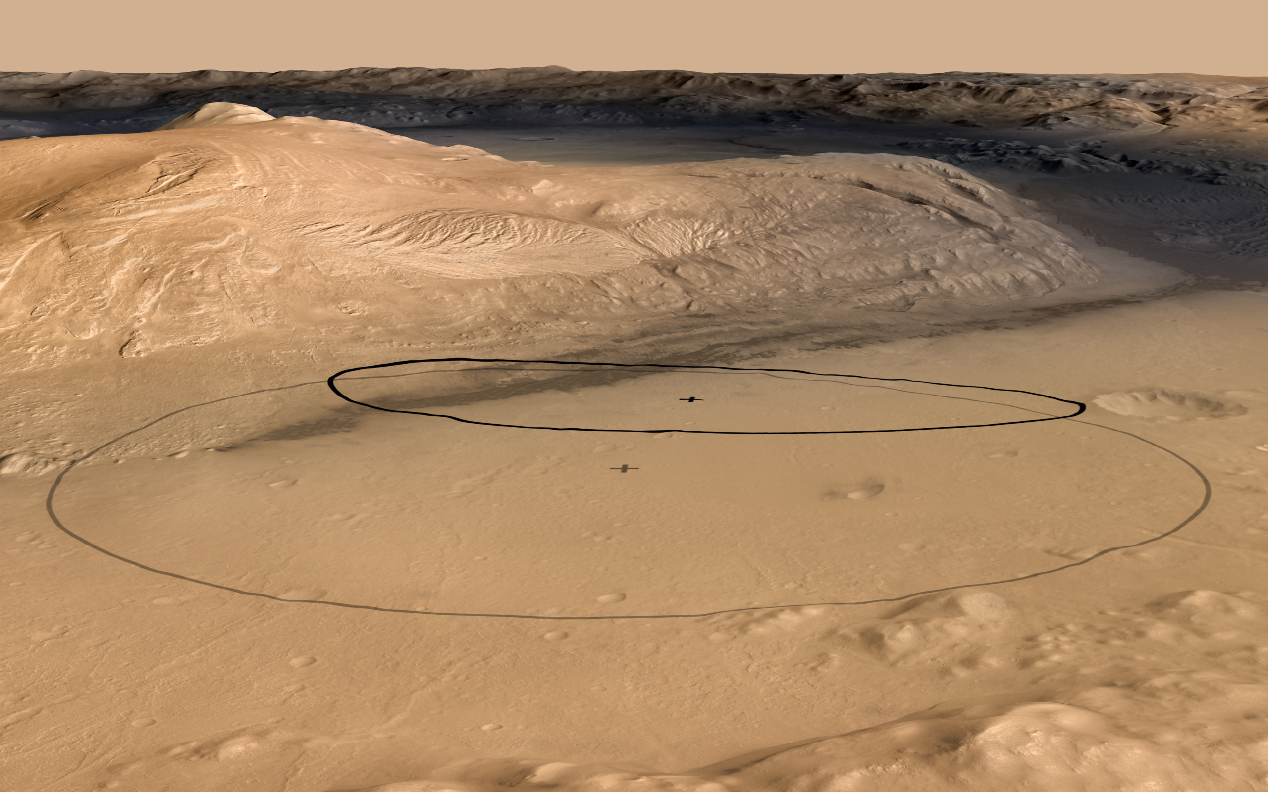
Mars Express jugará un papel muy importante durante los ‘siete minutos de terror’ que durará la maniobra de entrada, descenso y aterrizaje sobre la superficie de Marte de Curiosity, monitorizando la maniobra y registrando las señales de la nave. La sonda europea ha estado tomando imágenes del cráter Gale que han permitido afinar el lugar previsto para el aterrizaje de este rover del tamaño de un coche. 
Download:
 Oblique view of Mount Sharp inside Gale Crater, with the original and revised landing ellipses marked. Credits: NASA/JPL-Caltech/ESA/DLR/FU Berlin/MSSS
 El rover Curiosity, parte de la misión MSL (Mars Science Laboratory) de la NASA, tenía previsto aterrizar en el interior de una elipse de 20 x 25 kilómetros, una diana bastante más pequeña que la de cualquiera de sus predecesores, gracias a los sofisticados sistemas de aterrizaje de precisión que incorpora MSL. Los datos de la elevación del terreno obtenidos gracias a la Cámara Estéreo de Alta Resolución (HRSC) de Mars Express, combinados con las imágenes de la Cámara Contextual del satélite MRO de la NASA y con las tomadas por las sondas Viking en los años setenta han permitido reducir el tamaño de la elipse a tan sólo 20 x 7 km.
 

Download:

This artist's concept depicts the moment that NASA's Curiosity rover touches down onto the Martian surface. The entry, descent, and landing (EDL) phase of the Mars Science Laboratory mission begins when the spacecraft reaches the Martian atmosphere, about 81 miles (131 kilometers) above the surface of the Gale crater landing area, and ends with the rover safe and sound on the surface of Mars.
Entry, descent, and landing for the Mars Science Laboratory mission will include a combination of technologies inherited from past NASA Mars missions, as well as exciting new technologies. Instead of the familiar airbag landing systems of the past Mars missions, Mars Science Laboratory will use a guided entry and a sky crane touchdown system to land the hyper-capable, massive rover.
The sheer size of the Mars Science Laboratory rover (over one ton, or 900 kilograms) would preclude it from taking advantage of an airbag-assisted landing. Instead, the Mars Science Laboratory will use the sky crane touchdown system, which will be capable of delivering a much larger rover onto the surface. It will place the rover on its wheels, ready to begin its mission after thorough post-landing checkouts.
The new entry, descent and landing architecture, with its use of guided entry, will allow for more precision. Where the Mars Exploration Rovers could have landed anywhere within their respective 93-mile by 12-mile (150 by 20 kilometer) landing ellipses, Mars Science Laboratory will land within a 12-mile (20-kilometer) ellipse! This high-precision delivery will open up more areas of Mars for exploration and potentially allow scientists to roam "virtually" where they have not been able to before.
In the depicted scene, Curiosity is touching down onto the surface, suspended on a bridle beneath the spacecraft's descent stage as that stage controls the rate of descent with four of its eight throttle-controllable rocket engines. The rover is connected to the descent stage by three nylon tethers and by an umbilical providing a power and communication connection. When touchdown is detected, the bridle will be cut at the rover end, and the descent stage flies off to stay clear of the landing site.
NASA's Jet Propulsion Laboratory, a division of the California Institute of Technology, Pasadena, Calif., manages the Mars Science Laboratory Project for the NASA Science Mission Directorate, Washington.
More information about Curiosity is at http://mars.jpl.nasa.gov/msl/.
Credits: NASA/JPL-Caltech
Curiosity aterrizará cerca de la montaña Gale

Este ajuste desplazó el centro de la elipse hacia la montaña que se encuentra en el centro del cráter Gale, de 154 kilómetros de diámetro.
El pico central de Gale – conocido coloquialmente como Monte Sharp – se eleva 5.5 km sobre el fondo del cráter, y es el principal objetivo de la misión de Curiosity.
Los satélites en órbita a Marte han identificado minerales arcillosos en esta región que parecen indicar que contuvo grandes cantidades de agua en algún momento de su pasado. Curiosity analizará muestras de estos materiales en su propio laboratorio de a bordo en busca de su propio tesoro: los componentes fundamentales de la vida.
ESA
Guillermo Gonzalo Sánchez Achutegui
ayabaca@gmail.com
ayabaca@hotmail.com
ayabaca@yahoo.com  
 Inscríbete en el Foro del blog y participa : A Vuelo De Un Quinde - El Foro!

viernes, 3 de agosto de 2012

MARTE: El lecho agrietado de la cuenca Ladon

Hola amigos: A VUELO DE UN QUINDE EL BLOG., La sonda Mars Express de la ESA nos muestra la parte sur de un cráter parcialmente enterrado de unos 440 km de diámetro, conocido como la cuenca Ladon. Estas imágenes, tomadas cerca de donde Ladon Valles desemboca en esta gran cuenca de impacto, presentan un gran número de singularidades, entre las que destaca el lecho agrietado de los cráteres Sigli y Shambe.

Download:
High-Resolution Stereo Camera (HRSC) nadir and colour channel data taken during revolution 10602 on 27 April 2012 by ESA’s Mars Express have been combined to form a natural-colour view of the Ladon Valles region. Centred at around 18°S and 329°E, this image has a ground resolution of about 20 m per pixel. The image shows the interconnected craters Sigli and Shambe, believed to have formed when a large meteorite fragmented in to two pieces just before impact. Extensive fracturing can be seen within the craters. Above the craters (west), creek-like flow channels can be seen leading in to the wider impact basin region to the right (north). 
Credits: ESA/DLR/FU Berlin (G. Neukum)


 La sonda Mars Express de la ESA nos muestra la parte sur de un cráter parcialmente enterrado de unos 440 km de diámetro, conocido como la cuenca Ladon. Estas imágenes, tomadas cerca de donde Ladon Valles desemboca en esta gran cuenca de impacto, presentan un gran número de singularidades, entre las que destaca el lecho agrietado de los cráteres Sigli y Shambe.

Estas fotografías fueron tomadas el pasado día 27 de abril por la Cámara Estéreo de Alta Resolución (HRSC) de Mars Express, y son de gran interés para la comunidad científica, ya que muestran antiguos lechos de lagos y ríos en la superficie de Marte.

Los cráteres Holden y Eberswalde se encontraban entre los cuatro candidatos para el lugar de aterrizaje de la sonda MSL (Mars Science Laboratory) de la NASA, que finalmente se posará sobre el cráter Gale el próximo lunes 6 de agosto.
Esta región está marcada por el flujo de grandes cantidades de agua, que en un pasado remoto descendían desde las tierras altas del sur de Marte. El agua excavó el gran Ladon Valles, hasta desembocar en la cuenca Ladon, una antigua cuenca de impacto de impresionantes dimensiones. 

Download:
 HI-RES JPEG (Size: 1039 kb)  HI-RES TIFF (Size: 16 088 kb)
This computer-generated perspective view was created using data obtained from the High-Resolution Stereo Camera (HRSC) on ESA’s Mars Express. Centred at around 18°S and 329°E, this image has a ground resolution of about 20 m per pixel. Sigli and Shambe dominate this image, which highlights the deep fracturing within the crater walls. The shape of the craters leads scientists to believe they were formed from the same impactor, which fragmented into two pieces just before hitting Mars. 
Credits: ESA/DLR/FU Berlin (G. Neukum)
 
Los cráteres elípticos como los que se pueden ver en esta imagen son el resultado del impacto oblicuo de asteroides o cometas contra la superficie del planeta. Los científicos han sugerido que el patrón fluidificado que se puede distinguir sobre la capa de material que fue arrancado del cráter podría indicar la presencia de hielo bajo la superficie del planeta, que se fundió en el momento del impacto. Choques posteriores dieron lugar a los cráteres más pequeños que salpican la capa original de escombros.

Download:
 Ladon basin is seen here in broader context. The smaller rectangle shows the region covered in this ESA Mars Express HRSC image release. Ladon Valles, which flows in to Ladon basin, is north of the well-known craters Holden and Eberswalde, which were potential landing-site candidates for NASA’s Mars Science Laboratory. 
Credits: NASA MGS MOLA Science Team


 Se piensa que los cráteres superpuestos Sigli y Shambe se formaron más tarde, cuando un asteroide se partió en dos instantes antes de chocar contra el suelo. Estos dos cráteres se fueron llenando de sedimentos con el paso del tiempo. 


Download:
This computer-generated perspective view was created using data obtained from the High-Resolution Stereo Camera (HRSC) on ESA’s Mars Express. Centred at around 18°S and 329°E, this image has a ground resolution of about 20 m per pixel. Above the interconnected craters of Sigli and Shambe (west), flow channels can be seen leading in to the large impact basin. The outflow of Ladon Valles itself can be seen towards the bottom of the image (east). Scientists have detected clay minerals within these deposits, suggesting the relatively long-lasting presence of liquid water in the past. 
Credits: ESA/DLR/FU Berlin (G. Neukum)


El fondo de estos cráteres está marcado por profundas grietas, que contrastan con las líneas más sutiles y redondeadas que surcan la parte central y derecha de la imagen. Estas últimas se extienden más allá de los límites de la imagen, formando patrones concéntricos, y se piensa que son el resultado de la compactación de la región bajo el peso de la inmensa cantidad de sedimentos que el tiempo fue depositando en el interior de la cuenca de impacto.


Download:
 HI-RES JPEG (Size: 753 kb)  HI-RES TIFF (Size: 88 435 kb)
This colour-coded plan view is based on a digital terrain model of the region, from which the topography of the landscape can be derived. The colour coding brings in to stark relief the fracturing inside Sigli and Shambe and the winding flow channels above (west) of the craters leading in to the relatively flat impact basin. Centred at around 18°S and 329°E, the image has a ground resolution of about 20 m per pixel. Credits: ESA/DLR/FU Berlin (G. Neukum)
 

 La desembocadura de Ladon Valles en la cuenca de Ladon se encuentra al este de los cráteres Sigli y Shambe, cerca de la parte inferior de esta imagen. Aquí, al igual que en otros puntos de la región, se pueden distinguir depósitos estratificados de un tono más claro. Los investigadores han descubierto que están formados por minerales arcillosos, lo que sugiere que hubo agua líquida en la región durante un periodo de tiempo considerable.


Download:
Ladon Valles imaged during revolution 10602 on 27 April 2012 by ESA’s Mars Express using the High-Resolution Stereo Camera (HRSC). Data from HRSC’s nadir channel and one stereo channel are combined to produce this anaglyph 3D image that can be viewed using stereoscopic glasses with red–green or red–blue filters. The image shows the concentric arc-shaped fractures in the wider impact basin, as well as the more extensive fracturing inside the interconnected craters Sigli and Shambe. Centred at around 18°S and 329°E, the image has a ground resolution of about 20 m per pixel. 
Credits: ESA/DLR/FU Berlin (G. Neukum)


 Finalmente, también se pueden distinguir estructuras dendríticas serpenteando hacia la cuenca de impacto, por encima de los cráteres Sigli y Shambe, una muestra más de la acción del agua en la región.
ESA
Guillermo Gonzalo Sánchez Achutegui
ayabaca@gmail.com
ayabaca@hotmail.com
ayabaca@yahoo.com 

 Inscríbete en el Foro del blog y participa : A Vuelo De Un Quinde - El Foro!

Mi lista de blogs