Mostrando entradas con la etiqueta Ariane 5. Mostrar todas las entradas

domingo, 11 de septiembre de 2016

ESA : Fantastic four: November’s Galileos reach Europe’s Spaceport.- Cuatro fantásticos satélites GALILEOS, ya se encuentran en el Puerto Europeo de Lanzamientos Espaciales para lanzarlos en noviembre....

 http://www.esa.int/Our_Activities/Navigation/Galileo/Launching_Galileo/Fantastic_four_November_s_Galileos_reach_Europe_s_Spaceport                                                                                           
Un vuelo trasatlántico entregó cuatro satélites Galileo a la Guayana francesa el martes, en preparación para el lanzamiento compartido  de este mes de noviembre  por Ariane 5 - la primera constelación de navegación por satélite europeo..................
 

Galileo quartet landing

Fantastic four: November’s Galileos reach Europe’s Spaceport

9 September 2016 A transatlantic flight delivered four Galileo satellites to French Guiana on Tuesday, in preparation for a shared launch this November by Ariane 5 – the first for Europe’s satnav constellation.
The satellites’ odyssey began the previous day, when they left ESA’s technical centre in Noordwijk, the Netherlands, where every Galileo satellite is tested.
Each satellite was placed into protective containers before leaving the cleanroom environment of the test facility. These containers incorporate sophisticated environmental control, satellite monitoring systems and shock absorbers.
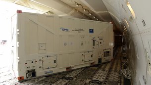
 

Galileo container unloaded
 
They were then driven by separate lorries to Luxembourg Findel Airport. On Tuesday morning they were flown by 747 aircraft to Cayenne–Félix Eboué Airport in French Guiana, touching down around 10:30 local time.
They were taken to the S1A payload preparation building of the Guiana Space Centre, to be unboxed the following day.
The building will remain their home as their launch campaign begins. The first activity is a ‘fit check’ with the dispenser that will release them into orbit from the rocket’s upper stage.
The modified Ariane 5 that will carry the four Galileos into orbit arrived in French Guiana a fortnight ago.
In development since 2012, this new variant has evolved from the Ariane 5 used to place ESA’s 20 tonne supply ferry for the International Space Station into low orbit.
This new version will carry a lighter payload – four fully fuelled 738 kg Galileo satellites plus their dispenser – but must take it up to the much higher altitude of 23 222 km.
 

Satellites leaving ESTEC
 
November’s launch is a major step up for Galileo. The 14 Galileo satellites already in orbit have been launched two at a time, by Soyuz from French Guiana.
Having 18 satellites in orbit should enable initial Galileo operational services to begin, a decision that will be taken by the European Commission, the system’s owner.
Two more Galileo launches by Ariane 5 are due in the next two years.

About Galileo
 

Galileos on the road

Galileo is Europe’s civil global satellite navigation system. It will allow users worldwide to know their exact position in time and space with great precision and reliability. Once complete, the system will consist of 24 operational satellites and the ground infrastructure for the provision of positioning, navigation and timing services.
The Galileo programme is funded and owned by the EU. The European Commission has the overall responsibility for the programme, managing and overseeing the implementation of all programme activities.
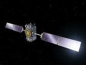
 

Galileo
 
Galileo’s deployment, the design and development of the new generation of systems and the technical development of infrastructure are entrusted to ESA. The definition, development and in-orbit validation phases were carried out by ESA, and co-funded by ESA and the European Commission.
The European Global Navigation Satellite System Agency (GSA) is ensuring the uptake and security of Galileo. Galileo operations and provision of services will be entrusted to the GSA from 2017.

VERSIÓN EN ESPAÑOL :
Spain
http://www.esa.int/esl/ESA_in_your_country/Spain/Los_cuatro_fantasticos_el_Puerto_Espacial_Europeo_recibe_a_los_nuevos_satelites_Galileo

Los cuatro Galileo a punto de aterrizar

Los cuatro fantásticos: el Puerto Espacial Europeo recibe a los nuevos satélites Galileo

9 septiembre 2016 El martes pasado, cuatro satélites Galileo llegaron a la Guayana Francesa en un vuelo trasatlántico, dentro de los preparativos para su lanzamiento conjunto el próximo noviembre a bordo de un Ariane 5. Será la primera vez que se ponen en órbita cuatro satélites de esta constelación al mismo tiempo.
Su odisea comenzó el día antes, cuando salieron del centro tecnológico de la ESA en Noordwijk, Países Bajos, donde se prueban todos los satélites.
Cada satélite se introdujo en un contenedor de protección antes de abandonar el entorno de sala limpia de las instalaciones de ensayo. Estos contenedores incorporan un sofisticado sistema de control ambiental, así como sistemas de monitorización y amortiguadores. 
 

Un contenedor antes de su descarga

A continuación, se dirigieron en camiones independientes hasta el aeropuerto luxemburgués de Findel, desde donde volaron el martes por la mañana a bordo de un 747 con destino al aeropuerto Félix Eboué de Cayenne, en la Guayana Francesa, aterrizando sobre las 10:30 hora local.
Desde allí se trasladaron al edificio de preparación de carga útil S1A del Centro Espacial de la Guayana, donde fueron desembalados al día siguiente.
El edificio acogerá los cuatro satélites hasta que se inicie su campaña de lanzamiento. Lo primero será comprobar su estado con el dispensador que los pondrá en órbita desde la etapa superior del cohete. 
Este cohete, un Ariane 5 modificado, llegó a la Guayana Francesa dos semanas antes. En desarrollo desde 2012, se trata de una versión modificada del Ariane 5 utilizado para situar en órbita baja las 20 toneladas de la nave de suministro de la Estación Espacial Internacional.
Esta nueva versión transportará una carga útil menor —cuatro satélites Galileo de 738 kg llenos de combustible, además del dispensador correspondiente— pero tendrá que alcanzar una altitud mucho mayor, de 23.222 km. 
 

Los satélites salen de ESTEC

El lanzamiento de noviembre será un hito clave para el programa Galileo. Los 14 satélites ya en órbita fueron lanzados de dos en dos a bordo de cohetes Soyuz desde la Guayana Francesa.
La presencia de 18 satélites en órbita permitiría dar comienzo a los servicios iniciales de Galileo, pero la decisión depende de la Comisión Europea, propietaria del sistema.
En los próximos dos años se llevarán a cabo otros dos lanzamientos mediante cohetes Ariane 5 dentro del programa Galileo. 


Los satélites en camino

Galileo es el sistema global de navegación por satélite de carácter civil de la Unión Europea. Permite a usuarios de todo el mundo conocer su posición en el tiempo y en el espacio con gran precisión y fiabilidad. Una vez completado, el sistema estará formado por 24 satélites operativos y una infraestructura de tierra para la provisión de servicios de posicionamiento, navegación y determinación de la hora.
Galileo es financiado por la UE, que es la propietaria del programa. Su responsable es la Comisión Europea, que gestiona y supervisa la implementación de todas sus actividades.
 

Galileo

La Comisión ha encargado a la ESA el diseño, el desarrollo y la implantación de la nueva generación de sistemas, así como el desarrollo técnico de las infraestructuras. La ESA ha llevado a cabo las fases de definición, desarrollo y validación en órbita, financiadas conjuntamente por la ESA y la Comisión Europea.
La Autoridad Europea de Supervisión del sistema global de navegación por satélite (GSA) garantiza el uso y la seguridad de Galileo. A partir de 2017, la GSA se encargará de todas las operaciones de Galileo y de la provisión de servicios.
ESA
Guillermo Gonzalo Sánchez Achutegui
ayabaca@gmail.com
ayabaca@hotmail.com
ayabaca@yahoo.com
Inscríbete en el Foro del blog y participa : A Vuelo De Un Quinde - El Foro!

viernes, 2 de septiembre de 2016

ESA : Imágenes Semanales de ESA

http://www.esa.int/spaceinimages/Images/2016/08/Stellar_shrapnel">http://www.esa.int/spaceinimages/Images/2016/08/Stellar_shrapnel
http://esaintouch.net/
http://www.esa.int/spaceinimages/Images/2016/08/Ariane_5_liftoff_VA232
https://soundcloud.com/esa
http://www.esa.int/Highlights/Week_In_Images_22_26_August_2016
http://www.esa.int/Our_Activities/Telecommunications_Integrated_Applications/First_satellite-based_wildlife_monitoring_tool_for_airports

Stellar shrapnel

Details

Open/Close
  • Title Stellar shrapnel
  • Released 19/08/2016 12:41 pm
  • Copyright ESA/Hubble & NASA, Y. Chu
  • Description
    Several thousand years ago, a star some 160 000 light-years away from us exploded, scattering stellar shrapnel across the sky. The aftermath of this energetic detonation is shown here in this striking image from the NASA/ESA Hubble Space Telescope’s Wide Field Camera 3.
    The exploding star was a white dwarf located in the Large Magellanic Cloud, one of our nearest neighbouring galaxies. Around 97% of stars within the Milky Way that are between a tenth and eight times the mass of the Sun are expected to end up as white dwarfs. These stars can face a number of different fates, one of which is to explode as supernovae, some of the brightest events ever observed in the Universe. If a white dwarf is part of a binary star system, it can siphon material from a close companion. After gobbling up more than it can handle — and swelling to approximately one and a half times the size of the Sun — the star becomes unstable and ignites as a Type Ia supernova.
    This was the case for the supernova remnant pictured here, which is known as DEM L71. It formed when a white dwarf reached the end of its life and ripped itself apart, ejecting a superheated cloud of debris in the process. Slamming into the surrounding interstellar gas, this stellar shrapnel gradually diffused into the separate fiery filaments of material seen scattered across this skyscape.
  • Id 364183

TAGS

Open/Close

The real thing

Details

Open/Close
  • Title The real thing
  • Released 24/08/2016 12:16 pm
  • Copyright Airbus DS
  • Description
    The European Service Module that will power NASA’s Orion spacecraft to the Moon and beyond is taking shape in the assembly hall at Airbus Defence and Space,  Bremen, Germany. The spacecraft module will provide propulsion, electricity, water, oxygen and nitrogen and thermal control.
    Seen here is the primary structure that provides rigidity to the European Service Module much like the chassis of a car. It absorbs the vibrations and energy from launch while a secondary structure protects the module from micrometeoroids and space debris.
    Assembly of the thousands of components needed to build the advanced spacecraft started on 19 May with the arrival of the primary structure that was shipped from Turin, Italy, by Thales Alenia Space. In 2018 this structure will be an element of the European Service Module that will be launched into space, as part of the Orion spacecraft, on its first mission to fly more than 64 000 km beyond the Moon and back.
    In the background is a poster of ESA’s Automated Transfer Vehicle (ATV) that was also assembled in this hall in Bremen. Five ATVs flew to the International Space Station to deliver supplies and raise its orbit.  Developing ATV provided the experience necessary to develop the European Service Module in Europe.
  • Id 364275

TAGS

Open/Close

Ariane 5 liftoff VA232

Details

Open/Close
  • Title Ariane 5 liftoff VA232
  • Released 25/08/2016 12:16 am
  • Copyright ESA
  • Description On 24 August 2016, Ariane 5 flight VA232 lifted off from Europe’s Spaceport in French Guiana and delivered two satellites, Intelsat-33e and Intelsat-36, into their planned orbits.
  • Id 364290

TAGS

Open/Close
  • Click on the tags to find the matching images.
  • Activity Launchers
  • Mission Ariane

Proba-V views Great Salt Lake

Details

Open/Close
  • Title Proba-V views Great Salt Lake
  • Released 26/08/2016 9:14 am
  • Copyright ESA/Belspo – produced by VITO
  • Description Great Salt Lake, the largest salt lake in the western hemisphere, captured by ESA's Proba-V satellite last June.
    Launched on 7 May 2013, Proba-V is a miniaturised ESA satellite – less than a cubic metre – tasked with a full-scale mission: to map land cover and vegetation growth across the entire planet every two days.
    Its main camera’s continent-spanning 2250 km swath width collects light in the blue, red, near-infrared and mid-infrared wavebands at 300 m resolution and down to 100 m resolution in its central field of view.
    VITO Remote Sensing in Belgium processes and then distributes Proba-V data to users worldwide. An online image gallery highlights some of the mission’s most striking images so far, including views of storms, fires and deforestation.
  • Id 364330

TAGS

Open/Close

Italy earthquake displacement

Details

Open/Close
  • Title Italy earthquake displacement
  • Released 26/08/2016 5:31 pm
  • Copyright Contains modified Copernicus Sentinel data (2016)/ESA/ CNR-IREA
  • Description
    Combining two Sentinel-1 radar scans from 20 August (Sentinel-1B) and 26 August 2016 (Sentinel-1A), this interferogram shows changes that occurred during the 24 August earthquake that struck central Italy.
    The seven interferometric ‘fringes’ correspond to about 20 cm of surface deformation in the radar sensor line of sight.  Each fringe (which is associated to a colour cycle) corresponds to approximately 2.8 cm of displacement.
    Although Sentinel-1 has a swath width of 250 km over land surfaces, its pass over Italy on 26 August did not cover the entire area affected. Another acquisition planned for 27 August will cover the entire earthquake zone.
  • Id 364362

TAGS

Open/Close


Ascend - the wildlife management solution for airports

First satellite-based wildlife monitoring tool for airports

29 August 2016
Wildlife habitats close to airports pose a serious risk to safety at takeoff and landing. Thanks to ESA, a new service lets airports use satellites to identify and manage these areas.
Developed by Ascend XYZ in Denmark with ESA’s help, the service uses free images and data from Earth observation satellites combined with smart software.
Several airports in Denmark have tested the Ascend software and found it far easier to use than existing complicated standalone systems.
Focusing on risk sites has increased their efficiency and reduced costs and enabled them to comply with the legal requirement to monitor within a 13 km radius.
 
 
Detecting water via satellite
 
"Using Earth observation data is more efficient than on-ground monitoring, requiring fewer man-hours and lowering demands on resources which cuts costs while increasing flight safety,” commented Peter Hemmingsen, CEO at Ascend.
“This is especially valuable to smaller airports with fewer resources to meet the same safety standards as large airports.
“Free data from the latest Copernicus Sentinel satellites make this an affordable solution for airports.”
Two airports have already signed up to the service.
Several international airports from Germany, England and North America also plan to adopt it.
 
Registering a lake in Ascend
 
In the software, users can identify risk sites such as lakes, golf courses, rubbish dumps, seasonal crops and other areas that attract wildlife – birds in particular. This provides a full overview of all the sites around the airport.
Satellite pictures are updated weekly, so changes in the water levels of lakes and flooded fields can be monitored and the site visited. All actions can be documented in the software.
The software can also generate alerts such as reminders to visit a site, monitor it via the satellite images, or contact the authorities if changes occur.
Sites can be marked on maps and field personnel can visit specific areas guided by satellite navigation data from Ascend.
 
Field personnel locate sites through satnav
 
Reports and images generated in Ascend can also be used for auditing purposes and to create a wildlife management report. Without the Ascend solution, airports require a costly team of specialists to do this.
The cloud- and browser-based management system allows the information to be shared online between airport operators, ground staff, civil aviation authorities, the wildlife management team and others involved in airport operations.
Early next year, Ascend intends to extend their service to identify objects that exceed height restrictions in restricted areas.
“ESA’s ARTES Applications programme merges big space data with smart ideas,” noted Arnaud Runge, Ascend Project Manager at the Agency.
“Ascend is an excellent example of how space can increase efficiency, cuts costs, solve problems and, in this case, make our skies safer.”
ESA
Guillermo Gonzalo Sánchez Achutegui
ayabaca@gmail.com
ayabaca@hotmail.com
ayabaca@yahoo.com
Inscríbete en el Foro del blog y participa : A Vuelo De Un Quinde - El Foro!

domingo, 3 de noviembre de 2013

ESA : El ATV Albert Einstein pone fin por todo lo alto a una misión perfecta


El ATV Albert Einstein pone fin por todo lo alto a una misión perfecta

2 noviembre 2013
El cuarto Vehículo Automatizado de Transferencia de la ESA, el ATV Albert Einstein, ha puesto fin a su exitosa misión de servicio a la Estación Espacial Internacional esta tarde, desintegrándose de forma segura durante su reentrada en la atmósfera terrestre sobre una zona deshabitada del Pacífico Sur.
Los Vehículos Automatizados de Transferencia (ATV) son las naves espaciales más complejas jamás desarrolladas en Europa y los vehículos de reabastecimiento de la Estación Espacial Internacional (ISS) más grandes y versátiles.
ATV-4 launch
Con sus 20 toneladas al despegue, el ATV-4 se convirtió en la carga más pesada jamás lanzada por un Ariane 5 cuando partió el día 5 de junio desde el Puerto Espacial Europeo en la Guayana Francesa. La nave europea atracó en la Estación Espacial Internacional 10 días más tarde, transportando un cargamento de 2.480 kg compuesto por más de 1.400 elementos diferentes.
El Albert Einstein transportó suministros esenciales para mantener el complejo orbital en funcionamiento, y para permitir a los seis astronautas que lo habitan seguir realizando experimentos en condiciones de microgravedad.
El astronauta de la ESA Luca Parmitano supervisó el atraque automático de la nave, y fue el responsable de descargar y almacenar todos los equipos científicos, piezas de repuesto, suministros, ropa y comida que transportaba.
Unloading ATV-4
Entre la carga del ATV-4 se encontraban varios experimentos con emulsiones que ayudarán a la industria a desarrollar alimentos y medicamentos más duraderos, una bomba de agua de repuesto para el laboratorio europeo Columbus, un sistema de reciclaje de agua de la NASA, una antena GPS para el laboratorio japonés Kiboy una serie de herramientas impresas en 3D.
Durante los cinco meses que permaneció unido a la Estación, el ATV-4 encendió sus motores seis veces para elevar la órbita del complejo orbital, contrarrestando los efectos de la resistencia atmosférica. Sin este tipo de maniobras, realizadas tanto por los ATV como por las naves rusas Progress, la Estación terminaría cayendo de vuelta a la Tierra.
ATV-4 undocking
Antes de partir, los astronautas cargaron la bodega presurizada de la nave con equipos y materiales que ya no eran necesarios a bordo, liberando espacio en la Estación. En su viaje de vuelta el ATV-4 batió un nuevo récord, transportando la mayor carga de deshechos de toda la serie.
La nave europea se desacopló de la Estación el pasado día 28 de octubre a las 08:55 GMT (09:55 CET), y realizó una maniobra automática para situarse a 100 km por debajo de la Estación en una trayectoria segura de reentrada.
El Albert Einstein maniobró cuidadosamente para reentrar justo por debajo de la Estación Espacial, lo que ha permitido a los astronautas observar la fragmentación de la nave en la atmósfera superior, aportando una información sin precedentes sobre la física de la reentrada.
El ATV-4 y su cargamento se desintegraron de forma segura en la atmósfera superior el 2 de noviembre a las 12:04 GMT (13:04 CET).
ATV Control Centre
Los vehículos ATV llevan a cabo todas sus maniobras, incluido el atraque, de forma completamente autónoma bajo la supervisión del Centro de Control de ATV en Toulouse, Francia, gestionado conjuntamente por la ESA y por la agencia espacial francesa, CNES.
“La misión transcurrió sin problemas, lo que para mí y para el equipo del ATV, o de cualquier misión espacial, es algo estupendo”, comenta Alberto Novelli, responsable de la misión ATV-4.
“La normalidad con la que transcurrió esta cuarta misión demuestra la madurez del programa ATV e incrementa el registro de éxitos de la ESA de cara a futuros proyectos”.
La próxima nave de la serie, el ATV Georges Lemaître, ya se encuentra en la Guayana Francesa. En marzo del año que viene se empezará a cargar su bodega de suministros, para luego ensamblar los distintos módulos del ATV-5 y colocar el conjunto sobre el lanzador Ariane que lo pondrá en órbita a finales de junio.
Con la serie de cinco vehículos ATV, la ESA habrá pagado su contribución por el uso de la Estación hasta finales de 2017.
La ESA contribuye de forma significativa al mantenimiento de la Estación, cubriendo los gastos relacionados con la operación de sus propios elementos – el laboratorio Columbus y su conjunto de experimentos y equipos científicos – así como con los vuelos periódicos de sus astronautas.

La Agencia Espacial Europea

ATV-4 docked to Station
La Agencia Espacial Europea (ESA) es la puerta de Europa al espacio. Es una organización intergubernamental creada en 1975 con la misión de coordinar el desarrollo de la capacidad espacial europea y de garantizar que la inversión en el sector espacial se traduzca en beneficios para los ciudadanos de Europa, y del mundo en general.
La ESA está compuesta por 20 Estados miembros: Alemania, Austria, Bélgica, Dinamarca, España, Finlandia, Francia, Grecia, Irlanda, Italia, Luxemburgo, Noruega, Países Bajos, Polonia, Portugal, Reino Unido, República Checa, Rumanía, Suecia y Suiza, de los cuales 18 también son miembros de la Unión Europea.
La ESA tiene Acuerdos de Cooperación con otros ocho Estados miembros de la UE. Canadá participa en algunos de los programas de la ESA a través de un Acuerdo de Cooperación.
La ESA colabora con la Unión Europea para la implementación de los programas Galileo y Copérnico.
Al coordinar los recursos financieros e intelectuales de sus miembros, la ESA puede emprender programas y actividades que quedarían fuera del alcance individual de cualquier país europeo.
La ESA desarrolla los lanzadores, los satélites y la infraestructura de tierra necesaria para mantener a Europa en la vanguardia de las actividades espaciales.
La Agencia Espacial Europea lanza satélites para la observación de la Tierra, para la navegación, las telecomunicaciones y la astronomía, envía sondas a los confines del Sistema Solar y colabora en la exploración tripulada del espacio.
Puedes encontrar más información en www.esa.int

Para más información:
ESA Media Relations Office
Tel: +33 1 53 69 72 99
Email: media@esa.int
 
ESA
Guillermo Gonzalo Sánchez Achutegui

jueves, 5 de julio de 2012

Astronomy: MSG-3 set to ensure quality of Europe’s weather service from geostationary orbit

Hi My Friends: A VUELO DE UN QUINDE EL BLOG., The latest weather satellite in Europe’s highly successful Meteosat second-generation series is on its way after lifting off on an Ariane 5 at 21:36 GMT (23:36 CEST) on Thursday, 5 July from Europe’s Spaceport at the Guiana Space Centre in  Kourou,   French Guiana.
 Carried on an Ariane 5, the latest weather satellite in Europe’s highly successful Meteosat Second Generation series, MSG-3, lifted off from Europe's Spaceport in Kourou, French Guiana, on 5 July 2012. The launch of MSG-3 ensures the continuity of meteorological observations to improve weather forecasts from geostationary orbit 36 000 km above Earth. ESA has developed the series of weather satellites in close cooperation with the European Organisation for the Exploitation of Meteorological Satellites, Eumetsat.

Credits: ESA

 The satellite’s sensors will ensure that Europe and Africa continue to receive up-to-date weather coverage.
Some 34 minutes into flight, the third Meteosat Second Generation satellite was released into its targeted elliptical transfer orbit. It is now being controlled from ESA’s European Space Operations Centre, in Darmstadt, Germany.
In ten days, once the initial operations are completed, MSG-3 will be handed over to the satellite’s owner, the European Organisation for the Exploitation of Meteorological Satellites – EUMETSAT – to commission the payload.
After commissioning, when MSG-3 has become Meteosat-10, it will be stationed at 0° longitude, over the Gulf of Guinea on the Equator, in geostationary orbit, where its speed precisely matches Earth’s rotation.
“Tonight’s launch allows EUMETSAT and ESA to continue providing Europeans with high quality observations of weather from space, with MSG-3 being especially valuable in rapid detection and warning of extreme weather situations,” said ESA’s Director General, Jean-Jacques Dordain.
“For more than three decades now, the exemplary cooperation between ESA and EUMETSAT has been the basis of the success of the Meteosat and EPS/Metop programmes.
“These programmes have ensured high-quality weather forecasts, the successive generations have improved these forecasts and they have brought tangible economic benefits for and improving the daily life of every European. Two generations have now been developed by ESA and EUMETSAT.”
“MSG-3 ensures the continuity of the present service. Together with EUMETSAT, ESA is working on the development of the next series of weather satellites, Meteosat Third Generation”, said ESA’s Director of Earth Observation, Volker Liebig.
“Once operational at the end of this decade, this next generation will provide a quantum leap in terms of technology and performance, providing among others faster imaging, more spectral channels and an atmospheric sounding capability allowing for the measurements of trace gas profiles.”
ESA’s role in weather and climate watch is not limited to the Meteosat series of satellites. It has also developed the MetOp series of polar-orbiting weather satellites - also operated by EUMETSAT - planned to be followed by the MetOp Second Generation series– to be submitted to the ESA Ministerial Council in November for approval.
The second MetOp is at the Baikonur Cosmodrome, Kazakhstan, ready for launch on 19 September.
About Meteosat Second Generation
MSG is a joint programme undertaken by ESA and EUMETSAT. ESA is responsible for the development of satellites fulfilling user and system requirements defined by EUMETSAT and of the procurement of recurrent satellites on its behalf. ESA also performs the Launch and Early Orbit Phase operations required to place the spacecraft in geostationary orbit, before handing it over to EUMETSAT for exploitation.
EUMETSAT develops all ground systems required to deliver products and services to users and to respond to their evolving needs, procures launch services and operates the full system for the benefit of users.
MSG-3 is the third in a series of four satellites introduced in 2002. These spin-stabilised satellites carry the primary Spinning Enhanced Visible and Infrared Imager, or SEVIRI.
SEVIRI focuses on Europe and Africa to deliver enhanced weather coverage, in order to improve local forecasts, in particular for rapidly developing storms. It scans Earth’s surface and atmosphere every 15 minutes in 12 different wavelengths, to track cloud development and measure temperatures.
SEVIRI can pick out features as small as a kilometre across in the visible bands, and three kilometres in the infrared.
In addition to its weather-watching mission and collection of climate records, MSG-3 has two secondary payloads.
The Global Earth Radiation Budget sensor will measure the amount of solar energy that is radiated back into space to determine how much energy is introduced into the climate system and to provide insights into the atmospheric circulation between the day and night sides. A Search & Rescue transponder will turn the satellite into a relay for distress signals from emergency beacons.
The MSG satellites were built in Cannes, France, by a European industrial team led by Thales Alenia Space, France. More than 50 subcontractors from 13 European countries are involved.
The last of the series, MSG-4, is planned for launch in 2015.
 

About the European Space Agency
The European Space Agency (ESA) is Europe’s gateway to space.
ESA is an intergovernmental organisation, created in 1975, with the mission to shape the development of Europe’s space capability and ensure that investment in space delivers benefits to the citizens of Europe and the world.
ESA has 19 Member States: Austria, Belgium, the Czech Republic, Denmark, Finland, France, Germany, Greece, Ireland, Italy, Luxem-bourg, the Netherlands, Norway, Portugal, Romania, Spain, Sweden, Switzerland and the United Kingdom, of whom 17 are Member States of the EU. ESA has Cooperation Agreements with nine other Member States of the EU and is negotiating an Agreement with the one remaining (Bulgaria). Poland is in the process of becoming ESA’s 20th Member State. Canada takes part in some ESA programmes under a Cooperation Agreement.
By coordinating the financial and intellectual resources of its members, ESA can undertake programmes and activities far beyond the scope of any single European country.
ESA develops the launchers, spacecraft and ground facilities needed to keep Europe at the forefront of global space activities. Today it launches satellites for Earth observation, navigation, telecommunications and astronomy, sends probes to the far reaches of the Solar System and cooperates in the human exploration of space.
For further information, please contact:
ESA Media Relations Office
 ESA
 Guillermo Gonzalo Sánchez Achutegui
 ayabaca@gmail.com
 ayabaca@hotmail.com
 ayabaca@yahoo.com
 Inscríbete en el Foro del blog y participa : A Vuelo De Un Quinde - El Foro!

miércoles, 16 de mayo de 2012

Astronomía: Segundo lanzamiento de Ariane 5 en 2012

Hola amigos: A VUELO DE UN QUINDE EL BLOG., En la madrugada de hoy, un lanzador Ariane 5 partía del Puerto Espacial Europeo, en la Guayana Francesa, con la misión de poner en una órbita de transferencia geoestacionaria a dos satélites de telecomunicaciones, JCSAT-13 y Vinasat-2
 An Ariane 5 launcher lifted off from Europe’s Spaceport in French Guiana on 16 May 2012 on its mission to place two telecommunications satellites, JCSAT-13 and Vinasat-2, into their planned transfer orbits.
Liftoff of flight VA206, the 62nd Ariane 5 mission, came at 22:13 GMT (00:13 CEST; 19:13 French Guiana). 
Credits: Arianespace

 En la madrugada de hoy, un lanzador Ariane 5 partía del Puerto Espacial Europeo, en la Guayana Francesa, con la misión de poner en una órbita de transferencia geoestacionaria a dos satélites de telecomunicaciones, JCSAT-13 y Vinasat-2.

El despegue del vuelo VA206, el número 206 del programa Ariane y el número 62 de Ariane 5, se produjo a las 22:13 GMT (00:13 CEST; 19:13 hora local en la Guayana Francesa). Los dos satélites fueron inyectados en una órbita de transferencia geoestacionaria con un perigeo de 249.9 km y un apogeo de 35 911 km, y 2° de inclinación con respecto al plano ecuatorial de la Tierra.
Los satélites JCSAT-13 y Vinasat-2 fueron liberados en sus respectivas órbitas de transferencia 26 y 36 minutos después del lanzamiento.
JCSAT-13 se posicionará sobre el ecuador a 124°E de longitud, desde donde proporcionará servicios de retransmisión de televisión a Japón. JCSAT-13 está preparado para atender a la creciente demanda de servicios de telecomunicaciones en los países del Sudeste Asiático.
Vinesat-2 ocupará la posición orbital de 131.8° de longitud Este, proporcionando enlaces de radio, televisión y telefonía a Vietnam.
La masa total de la carga útil para este lanzamiento fue de 8381 kg, 7563 kg de los dos satélites y 818 kg de los adaptadores y mecanismos de separación. 
Secuencia de eventos del vuelo VA204

La secuencia de lanzamiento comenzó con el encendido del motor principal criogénico del lanzador. Siete segundos más tarde empezaron a rugir los dos motores laterales de combustible sólido. El Ariane 5 comenzó a elevarse sobre la plataforma de lanzamiento apenas una fracción de segundo más tarde.
Los motores de combustible sólido se separaron a los 2 min 25 s, y la carena aerodinámica que protegía a los satélites durante la fase atmosférica del vuelo lo hizo a los 3 min 11 s.
El motor principal del lanzador se apagó a los 8 min 54 s; seis segundos más tarde, la etapa principal criogénica se separó del conjunto formado por la etapa superior y por los satélites.
Cuatro segundos después, se encendió el motor de la etapa superior del lanzador, también criogénica. Este motor se apagó a los 25 min 01 s, momento en el que el vehículo alcanzaba las condiciones para la inyección en la órbita de transferencia prevista, viajando a 9339 m/s (33 620.4 km/h), a 669.9 km sobre la superficie de la Tierra.
JCSAT-13 se separó de la etapa superior a los 26 min 35 s, seguido por Vinasat-2 a los 36 min 01 s. Las operaciones de lanzamiento concluyeron a los 48 min 30 s tras el encendido del motor principal de la primera etapa.
ESA. 
Guillermo Gonzalo Sánchez Achutegui
 ayabaca@gmail.com
 ayabaca@hotmail.com
 ayabaca@yahoo.com
 Inscríbete en el Foro del blog y participa : A Vuelo De Un Quinde - El Foro!

Mi lista de blogs