Blog dedicado a cuentos, notas de interés, actividades políticas , sociales, historia, artes culinarias, fiestas patronales, astronomía, ciencia ficción, temas del Medio Ambiente ,y del acontecer Peruano y Mundial desde otro punto de vista muy personal y diferente!!!!!
********** Blog Fundado el 03 de Enero del 2008 **********
La tensión transfronteriza generada por el candidato republicano a la presidencia de Estados Unidos Donald Trump no cesa de intensificarse a medida que avanza la campaña.
Ha llegado a tal punto que esta semana la mera posibilidad de que el magnate gane la carrera a La Casa Blanca ha puesto en tela de juicio hasta un acuerdo que se logró hace 168 años.
El republicano ha prometido expulsar masivamente a mexicanos que se encuentren de forma ilegal en su país y construir un muro fronterizo a expensas de México.
Pero ante la amenaza de Trump de revertir o anular el Tratado de Libre Comercio de Norteamérica (TLCAN, también conocido como NAFTA, por sus siglas en inglés), un senador mexicano propuso revisar todos los acuerdos bilaterales entre los dos países.
Este incluye el Tratado de Paz, Amistad, Límites y Arreglo de 1848, que se puso fin a la guerra mexicano-estadounidense y con la que se transfirió una gran parte del territorio de México a EE.UU., incluyendo lo que hoy es California, Arizona, Nuevo México y Nevada.
Image copyrightThinkstockImage caption El borde superior de la lupa está más cercano a lo que fue la frontera entre México y EE.UU. El conflicto marcó un cambio radical en las relaciones entre los dos países y uno de los momentos significativos ocurrió en septiembre de 1847.
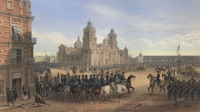
Fue entonces cuando Ciudad de México se convirtió en la primera capital extranjera en ser ocupada por el ejército estadounidense.
Antes del fin, la invasión
Tras una guerra de más de 20 meses, que dejó a su paso miles de bajas en ambos frentes, los soldados estadounidenses hicieron su entrada triunfal a la capital mexicana.
La bandera albiceleste estrellada ondeaba sobre el Palacio Nacional.
"A plena luz del día marchamos y tomamos posesión de la ciudadela. Hubo muchos enfrentamientos callejeros hoy y muchos de los nuestros resultaron heridos o muertos. (El presidente) Santa Anna y su ejército habían dejado la ciudad".
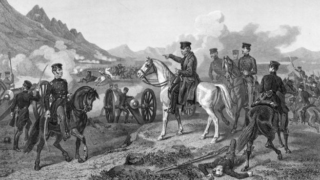
Así narró el suceso en uno de sus diarios Israel Uncapher, uno de los cabos comandados por el General Winfield Scott.
"Las pérdidas en nuestro regimiento son de unos 100 hombres muertos y heridos. 12 hombres en nuestra compañía fueron alcanzados por las balas... la lucha callejera no es tan generalizada como ayer. Algunos lanceros siguen peleando, pero los sacaremos de aquí hoy".
Ataques aéreos
La guerra entre los Estados Unidos de México y los Estados Unidos de América estaba por terminar, pero la inquietante ocupación de la capital mexicana apenas estaba empezando.
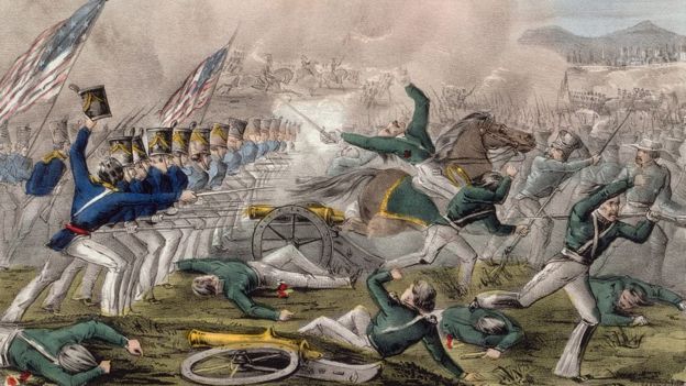
"Cuando entraron en la ciudad, tuvieron que desocupar los techos de las edificaciones, porque había mexicanos atacándolos", le dice a la BBC David Sim, profesor de Historia Norteamericana de la Universidad UCL de Londres.
"Y eso no cesó. Hay muchas historias de soldados estadounidenses alcanzados por rocas o basura". Image copyrightJohn Cameron/Nathaniel Currier/Library of CongressImage caption Para cuando EE.UU. ocupó Ciudad de México, ya habían pasado casi dos años de guerra y miles de muertos. México y EE.UU. habían estado en guerra desde la primavera de 1846 pero la raíz del conflicto se remontaba a la década anterior.
¿La razón? La disputa por el territorio de Texas.
Giro inesperado
En un principio, los mexicanos habían alentado a los colonos de su vecino del norte a que se establecieran en el territorio texano que en aquél entonces estaba bajo su control.
El incentivo era combatir juntos a los nativos americanos.
Pero en 1836 los colonos declararon la independencia y reclamaron la anexión a Estados Unidos.
Gobiernos estadounidenses sucesivos se mostraron reacios a generar el antagonismo de sus vecinos del sur y rechazaron la solicitud de Texas.
Hasta que en 1845 el presidente James Polk la aceptó y, como consecuencia, las tensiones transfronterizas escalaron.
Llamamiento a las armas
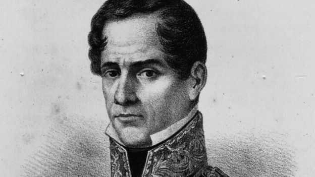
"Soldados, la hora de la verdad ha llegado. ¡A las armas! ¡La nación mexicana por siempre! ¡La independencia por siempre!", exclamó Francisco Mejía Matamoras el 18 de marzo de 1846. Image copyrightHulton ArchiveImage caption El que alguna vez tenía que ser llamado "Alteza Serenísima" no contaba con muchos simpatizantes. Pese al llamamiento a las armas, no muchos mexicanos sentían lealtad por el 11 veces presidente de México,Antonio de Padua María Severino López de Santa Anna y Pérez de Lebrón.
Sin embargo, estaban dispuestos a luchar por las tierras que poseían.
Pero la organización de un ejército nacional coordinado no fue fácil. Entre los estadounidenses, el caso era el contrario: incitados contra de los mexicanos, estaban llenos de fervor patriótico y motivados por la idea de conquistar nuevas tierras.
De Texas al sur
Las primeras batallas tuvieron lugar en el territorio texano, pero poco después las fuerzas estadounidenses cruzaron el Río Grande camino al norte de México.
Otras tropas se movilizaron hacia los territorios mexicanos de California y Nuevo México.
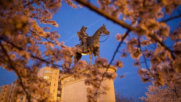
Llegado septiembre de 1846 las tropas estadounidenses ya estaban llegando a Monterrey. Image copyrightGetty ImagesImage caption Estatua de Winfield Scott quien sirvió a su país como general por más tiempo que ningún otro en la historia de Estados Unidos. "El enemigo intentó resistir desesperadamente, con disparos rápidos y constantes de su artillería y armas pequeñas, causando algunas pérdidas en nuestras filas... En la tarde del 22, Ampudia le ordenó a sus tropas que tomaran posiciones defensivas dentro de la ciudad, dando lugar a un amargo combate casa a casa", escribió el comandante Martin Scott luchó con la 5ª infantería estadounidense.
Tras tres días de incesantes luchas, el General mexicano Pedro Ampudia pidió una tregua. Seguida la tregua vino la rendición.
Con Monterrey asegurado, los estadounidenses continuaron su camino al sur.
Agua, viento y polvo
Pese a sentir que llevaban la ventaja, encontraron dificultades en el camino.
Luchar tan lejos de su territorio hacía todo más difícil.
Así se lamentaba un voluntario:
"Recibimos órdenes el miércoles pasado de irnos a Buena Vista, pues el agua era tan mala y el viento y el polvo tan desagradables que hasta afectaron a nuestros caballos y muchos murieron...
"Yo estuve de guardia el día anterior hasta la noche siguiente. Pasar todo un día bajo el caliente sol sin refugio y mantenerse despierto toda la noche con el frío viento no es buena preparación para una marcha difícil". Image copyrightHulton ArchiveImage caption En Buena Vista, los elementos vencieron al ejército estadounidense. No obstante, en marzo de 1874 el General Scott ya tenía 10.000 soldados en la costa este de México, al sur de Veracruz.
Un mes más tarde, en la batalla de Cerro Gordo, 3.000 soldados mexicanos fueron hechos prisioneros. La resistencia de los mexicanos se estaba desmoronando.
La toma del castillo
Para agosto de 1847, miles de soldados estadounidenses estaban en las afueras de la Ciudad de México.
En su reporte de batalla, el General Scott describió la escena.
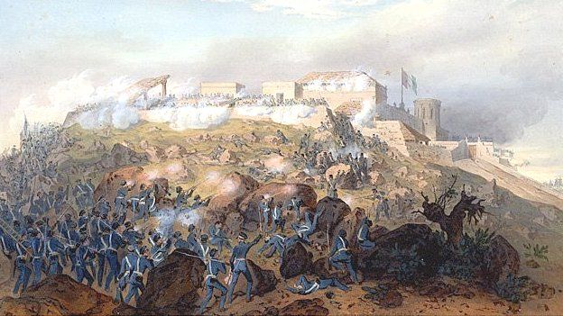
"Esta ciudad se erige en un bajo montículo, cerca del centro de una cuenca irregular y la mayor parte está ceñida a una zanja -un canal navegable de gran amplitud y profundidad- muy difícil de cruzar en presencia de un enemigo". Image copyrightCarl Nebel/Adolphe Jean-Baptiste BayotImage caption La escena que al General Scott le pareció gloriosa. El asalto principal a la ciudad empezó a principios de septiembre, con la toma del Castillo de Chapultepec, el centro de la defensa mexicana.
Desde el punto de vista del General Scott...
"El avance de nuestros valientes hombres, liderados por valientes oficiales, aunque necesariamente lento, fue inquebrantable, sobre las rocas, simas y minas, y bajo el fuego más caliente del cañón y fusilería. (...) El enemigo fue empujado constantemente de un refugio a otro. (...) Por fin llegaron a la zanja y el muro; las escaleras se alzaron (...) Ninguna escena podría haber sido más gloriosa".
Lo de gloriosa depende del lado del muro del Castillo de Chapultepec desde el que el líder de los ejércitos la estuviera observando. Lo que no cabe duda es que fue sangrienta.
Más de 5.000 mexicanos y 1.600 estadounidenses murieron o fueron heridos.
El presidente se retira
Al caer el castillo en manos del enemigo, el presidente Santa Anna se fue de la ciudad, dejando algunos rezagados para que hicieran lo que pudieran contra los victoriosos estadounidenses.
"De ese enemigo, alguna vez tan formidable en número y artillería, unos 20.000 se desbandaron desesperanzados, dejando a unos 2.500 deambulando en diferentes direcciones", reportó el General Scott. Image copyrightThinkstockImage caption Nuevo México dejó de ser parte de México. Durante los siguientes días, francotiradores y turbas aireadas continuaron atacando a los invasores, pero la mayoría de los ataques eran desorganizados y aleatorios.
Según los diario del cabo Israel Unchapher, el aburrimiento y la añoranza era lo que realmente ocupaba la mente de muchos de los soldados estadounidenses.
"Septiembre 18, sábado. Las tiendas están abriendo y la confianza retornando en ambas partes. La ciudad presenta una apariencia agradable desde que los negocios se reanudaron.
Miércoles. Desfile en uniforme. Nada nuevo.
Enero 7. Circulan rumores de que pronto retornaremos a casa".
Pero no retornaron a casa... no en ese momento.
De hecho, la ocupación se extendió hasta junio de 1848, para cuando el tratado de paz había sido firmado.
México fue forzado a renunciar a enormes territorios en Alta California y Nuevo México, así como Texas.
A cambio, recibió US$15 millones y la promesa de respetar los derechos de sus ciudadanos que seguían viviendo en esas áreas.
Desde entonces, son las aguas de Rio Grande las que marcan la frontera entre los dos países.
The remotely controlled Sally Ride EarthKAM aboard the International Space Station acquired this photograph on July 14, 2016, as the orbiting laboratory flew over Lake Powell and the border of Utah and Arizona. Located on the Colorado River, Lake Powell (annotated image) is the second largest artificial reservoir in the United States.
The EarthKAM program allows students to request photographs of specific Earth features, which are taken by a special camera mounted on the space station when it passes over those features. The images are posted online for the public and students in participating classrooms around the world to view.
EarthKAM is the only program providing students with such direct control of an instrument on a spacecraft orbiting Earth, teaching them about environmental science, geography and space communications. The project was initiated by Dr. Sally Ride, America’s first woman in space, in 1995 and called KidSat; the camera flew on five space shuttle flights before moving to the space station on Expedition 1 in 2001.
Hola amigos : A VUELO DE UN QUINDE EL BLOG., la Agencia Espacial NASA, nos informa de una espectacular vista de Glendale y Phoenix, en Arizona, captada desde la Estación Espacial Internacional por miembros de la Expedición 35, el 16 de marzo del 2013. Al igual quemuchas de las grandesáreas urbanas delcentro y oeste deEstadosUnidos, la zonametropolitana de Phoenixse presentaa lo largo deuna malla regulardemanzanasy calles.Si bienvisible durante eldía,esta redse hace más evidenteen la noche,cuando el patróndeiluminación de las calleses claramentevisible desde arriba.
En el caso deesta fotografía,desde elpunto de vistabajola órbita dela Tierrade la Estación EspacialInternacional.La formade cuadrículaurbanafomenta el crecimientode una ciudadhacia el exteriora lo largo desus fronteras,proporcionandoun acceso óptimo anuevos bienes inmuebles.Impulsado porla adopcióndel uso deautomóvil personalgeneralizadadurante el siglo 20, el áreametropolitana de Phoenixhoyincluye a otros25 municipios(muchos de ellosen gran partesuburbano y residencialde carácter) unidos poruna red decalles de la superficiey autopistas......
Super View of Glendale and Phoenix
One of the Expedition 35 crew members on the International Space Station used
a still camera with a 400 millimeter lens to record this nocturnal image of the
Phoenix, Arizona area on March 16, 2013. Like many large urban areas of the
central and western United States, the Phoenix metropolitan area is laid out
along a regular grid of city blocks and streets. While visible during the day,
this grid is most evident at night, when the pattern of street lighting is
clearly visible from above -- in the case of this photograph, from the low Earth
orbit vantage point of the International Space Station. The urban grid form
encourages growth of a city outwards along its borders, by providing optimal
access to new real estate. Fueled by the adoption of widespread personal
automobile use during the 20th century, the Phoenix metropolitan area today
includes 25 other municipalities (many of them largely suburban and residential
in character) linked by a network of surface streets and freeways. The image
area includes parts of several cities in the metropolitan area including Phoenix
proper (right), Glendale (center), and Peoria (left). While the major street
grid is oriented north-south, the northwest-southeast oriented Grand Avenue cuts
across it at image center. Grand Avenue is a major transportation corridor
through the western metropolitan area; the lighting patterns of large industrial
and commercial properties are visible along its length. Other brightly lit
properties include large shopping centers, strip centers, and gas stations which
tend to be located at the intersections of north-south and east-west trending
streets. While much of the land area highlighted in this image is urbanized,
there are several noticeably dark areas. The Phoenix Mountains at upper right
are largely public park and recreational land. To the west (image lower left),
agricultural fields provide a sharp contrast to the lit streets of neighboring
residential developments. The Salt River channel appears as a dark ribbon within
the urban grid at lower right.
A test version of NASA’s Orion spacecraft descends
under its three main parachutes above the U.S. Army Proving Ground in Arizona in
the agency’s most difficult test of the parachutes system’s performance. NASA is
preparing Orion for its first trip to space in December, a two-hour, four-orbit
flight that will send an uncrewed spacecraft more than 3,600 miles into space
before returning it to Earth to test the performance of many of the spacecraft’s
critical systems needed to carry crew to deep space destinations in the
future.
Image Credit: NASA/Rad Sinyak
NASA completed the most complex and flight-like test of the parachute system
for the agency's Orion spacecraft on Wednesday.
A test version of Orion touched down safely in the Arizona desert after being
pulled out of a C-17 aircraft, 35,000 feet above the U.S. Army's Yuma Proving
Ground. It was the first time some parachutes in the system had been tested at
such a high altitude. Engineers also put additional stresses on the parachutes
by allowing the test version of Orion to free fall for 10 seconds, which
increased the vehicle's speed and aerodynamic pressure.
"We've put the parachutes through their paces in ground and airdrop testing
in just about every conceivable way before we begin sending them into space on
Exploration Flight Test (EFT)-1 before the year's done," said Orion Program
Manager Mark Geyer. "The series of tests has proven the system and will help
ensure crew and mission safety for our astronauts in the future."
After Orion's free fall, its forward bay cover parachutes deployed, pulling
away the spacecraft's forward bay cover, which is critical to the rest of the
system performing as needed. The forward bay cover is a protective shell that
stays on the spacecraft until it has reentered Earth's atmosphere. The
parachutes that slow Orion to a safe landing speed are located under the cover,
so the cover must be jettisoned before they can be unfurled.
Engineers also rigged one of the main parachutes to skip the second phase of
a three-phase process of unfurling each parachute, called reefing. This tested
whether one of the main parachutes could go directly from opening a little to
being fully open without an intermediary step, proving the system can tolerate
potential failures.
The test also marked the last time the entire parachute sequence will be
tested before Orion launches into space in December on its first space flight
test, EFT-1. During the flight, an uncrewed Orion will travel 3,600 miles into
space, farther than any spacecraft built to carry humans has been in more than
40 years. Orion will travel at the speed necessary to test many of the systems
critical to NASA's ability to bring astronauts home safely from missions to deep
space, including an asteroid and eventually Mars.
During its return to Earth, Orion will reach a speed of up to 20,000 mph and
experience temperatures near 4,000 degrees Fahrenheit. Once Orion has made it
through the atmosphere, the parachute system, with two drogue parachutes and
three massive main parachutes that together cover almost an entire football
field will be responsible for slowing it down to just 20 mph for a safe
splashdown in the Pacific Ocean.
Orion's next parachute test is set for August and will test the combined
failure of one drogue parachute and one main parachute, as well as new parachute
design features. It is one of three remaining tests needed to demonstrate the
system's capability for human missions, but does not need to be completed before
Orion's first flight later this year.
In this composite image, visible-light
observations by NASA’s Hubble Space Telescope are combined with infrared
data from the ground-based Large Binocular Telescope in Arizona to
assemble a dramatic view of the well-known Ring Nebula.
Credit: NASA, ESA, C.R. Robert O’Dell (Vanderbilt University), G.J.
Ferland (University of Kentucky), W.J. Henney and M. Peimbert (National
Autonomous University of Mexico)
Credit for Large Binocular Telescope data: David Thompson (University of Arizona)
› Larger image
The Ring Nebula's distinctive shape makes it a popular illustration for
astronomy books. But new observations by NASA's Hubble Space Telescope
of the glowing gas shroud around an old, dying, sun-like star reveal a
new twist.
"The nebula is not like a bagel, but rather, it's like a jelly doughnut,
because it's filled with material in the middle," said C. Robert O'Dell
of Vanderbilt University in Nashville, Tenn. He leads a research team
that used Hubble and several ground-based telescopes to obtain the best
view yet of the iconic nebula. The images show a more complex structure
than astronomers once thought and have allowed them to construct the
most precise 3-D model of the nebula.
This planetary nebula's simple, graceful appearance is thought to be due
to perspective: our view from Earth looking straight into what is
actually a barrel-shaped cloud of gas shrugged off by a dying central
star. Hot blue gas near the energizing central star gives way to
progressively cooler green and yellow gas at greater distances with the
coolest red gas along the outer boundary.
"With Hubble's detail, we see a completely different shape than what's
been thought about historically for this classic nebula," O'Dell said.
"The new Hubble observations show the nebula in much clearer detail, and
we see things are not as simple as we previously thought."
The Ring Nebula is about 2,000 light-years from Earth and measures
roughly 1 light-year across. Located in the constellation Lyra, the
nebula is a popular target for amateur astronomers.
Previous observations by several telescopes had detected the gaseous
material in the ring's central region. But the new view by Hubble's
sharp-eyed Wide Field Camera 3 shows the nebula's structure in more
detail. O'Dell's team suggests the ring wraps around a blue,
football-shaped structure. Each end of the structure protrudes out of
opposite sides of the ring.
The nebula is tilted toward Earth so that astronomers see the ring
face-on. In the Hubble image, the blue structure is the glow of helium.
Radiation from the white dwarf star, the white dot in the center of the
ring, is exciting the helium to glow. The white dwarf is the stellar
remnant of a sun-like star that has exhausted its hydrogen fuel and has
shed its outer layers of gas to gravitationally collapse to a compact
object.
O'Dell's team was surprised at the detailed Hubble views of the dark,
irregular knots of dense gas embedded along the inner rim of the ring,
which look like spokes in a bicycle wheel. These gaseous tentacles
formed when expanding hot gas pushed into cool gas ejected previously by
the doomed star. The knots are more resistant to erosion by the wave of
ultraviolet light unleashed by the star. The Hubble images have allowed
the team to match up the knots with the spikes of light around the
bright, main ring, which are a shadow effect. Astronomers have found
similar knots in other planetary nebulae.
All of this gas was expelled by the central star about 4,000 years ago.
The original star was several times more massive than our sun. After
billions of years converting hydrogen to helium in its core, the star
began to run out of fuel. It then ballooned in size, becoming a red
giant. During this phase, the star shed its outer gaseous layers into
space and began to collapse as fusion reactions began to die out. A
gusher of ultraviolet light from the dying star energized the gas,
making it glow.
The outer rings were formed when faster-moving gas slammed into
slower-moving material. The nebula is expanding at more than 43,000
miles an hour, but the center is moving faster than the expansion of the
main ring. O'Dell's team measured the nebula's expansion by comparing
the new Hubble observations with Hubble studies made in 1998.
The Ring Nebula will continue to expand for another 10,000 years, a
short phase in the lifetime of the star. The nebula will become fainter
and fainter until it merges with the interstellar medium.
Studying the Ring Nebula's fate will provide insight into the sun's
demise in another 6 billion years. The sun is less massive than the Ring
Nebula's progenitor star, so it will not have an opulent ending.
"When the sun becomes a white dwarf, it will heat more slowly after it
ejects its outer gaseous layers," O'Dell said. "The material will be
farther away once it becomes hot enough to illuminate the gas. This
larger distance means the sun's nebula will be fainter because it is
more extended."
In the analysis, the research team also obtained images from the Large
Binocular Telescope at the Mount Graham International Observatory in
Arizona and spectroscopic data from the San Pedro Martir Observatory in
Baja California, Mexico.
The
Colorado Plateau spans northern Arizona, southern Utah, northwestern
New Mexico, and southwestern Colorado. This physiographic province is
well known for its striking landscapes and broad vistas—an impression
that is enhanced by the view from the orbital perspective of the
International Space Station. This astronaut photograph highlights part
of the Utah-Arizona border region of the Plateau, and includes several
prominent landforms.
The Colorado River, dammed to form Lake
Powell in 1963, crosses from east to west (which is left to right here
because the astronaut was looking south; north is towards the bottom of
the image). The confluence of the Colorado and San Juan Rivers is also
visible. Sunglint—sunlight reflected off a water surface back towards
the observer—provides a silvery, mirror-like sheen to some areas of the
water surfaces.
The geologic uplift of the Colorado Plateau led
to rapid downcutting of rivers into the flat sedimentary bedrock,
leaving spectacular erosional landforms. One such feature, The Rincon,
preserves evidence of a former meander bend of the Colorado River.
Semana Mundial del Ahorro en Perú
-
Semana Mundial del Ahorro en Perú “No ahorres lo que te queda después de
gastar, gasta lo que te queda después de ahorrar”, éstas son palabras
sabias del g...
EL CUERPO DE CRISTO
-
#lamentedeCristoelprimerdia
Ef 2: 19 Así que ya no sois extranjeros ni advenedizos, sino conciudadanos
de los santos, y miembros de la familia de Dios.
Fo...