Mostrando entradas con la etiqueta Spinning Enhanced Visible and Infrared Imager (SEVIRI). Mostrar todas las entradas

sábado, 16 de febrero de 2013

ESA - Russian asteroid strike


 Chelyabinsk asteroid vapour trail seen by Meteosat
  (82.95 kB)

 An image from the SEVIRI instrument aboard Eumetsat's Meteosat-10 geostationary satellite. The vapour trail visible in the centre of the image was left by an asteroid that struck Earth near Chelyabinsk, Russia, 15 February 2013, around 03:15 UT. Initial media reports included accounts of injuries and property loss. This image uses data from the High Resolution Visible (HRV) channel of SEVIRI that can produce images with both high spatial and temporal resolution.

A space rock a few metres across exploded in Earth’s atmosphere above the city of Chelyabinsk, Russia today at about 03:15 GMT. The numerous injuries and significant damage remind us that what happens in space can affect us all. 
While precise information on the size, mass and composition of the object are yet to be confirmed, videos show a fireball and explosion consistent with an asteroid up to a few metres in size exploding in the atmosphere, possibly several to ten kilometres above the surface.
In this type of event, if the explosion altitude is less than 10 km or so, the resulting shockwave can cause damage on the ground, such as shattering windows. Debris from the object may be found later.
“Current information, which is not yet complete nor confirmed, points to a small asteroid,” said Detlef Koschny, Head of Near-Earth Object activity at ESA’s Space Situational Awareness (SSA) programme office.
“There is no way it could have been predicted with the technical means available today. What can be said with near certainty is that this object has no connection with asteroid 2012 DA14.”
Asteroid 2012 DA14 made a close flyby of Earth at 19:27 GMT (20:27 CET) today. 
Finding objects that pass close to our planet and are large enough to do damage if they enter our atmosphere is a major goal of ESA’s SSA programme.
In addition to conducting its own sky searches using ESA's Optical Ground Station in Tenerife, Spain, SSA is partnering with existing European and international asteroid survey activities.  
It also sponsors astronomer groups in Europe, supporting surveys carried out with their own equipment or allocating observation time on its Tenerife telescope. The office also provides access to orbit predictions, close flyby details and related data via its technical website at http://neo.ssa.esa.int
“Today’s event is a strong reminder of why we need continuous efforts to survey and identify near-Earth objects,” said Thomas Reiter, ESA’s Director of Human Spaceflight and Operations.
“Our SSA programme is developing a system of automated optical telescopes that can detect asteroids and other objects in solar orbits.”
Today’s event is a strong reminder of why we need continuous efforts to survey and identify near-Earth objects.
In cooperation with survey efforts worldwide, ESA’s goal is to spot near-Earth objects larger than 40 m at least three weeks before closest approach to our planet.
To achieve this, ESA, European industry and partner agencies are developing a system of automated 1 m-diameter telescopes capable of imaging the complete sky in one night.
In addition to Russian media, who reported immediately, all media worldwide have published images of notable damage around Chelyabinsk, and reports also mention numerous casualties.
“Our most sincere sympathies are with those suffering injury and property loss due to this event in Russia,” added Thomas Reiter.
 ESA
 RELATED ARTICLES:


Guillermo Gonzalo Sánchez Achutegui
ayabaca@gmail.com
ayabaca@hotmail.com
ayabaca@yahoo.com
Inscríbete en el Foro del blog y participa : A Vuelo De Un Quinde - El Foro!

lunes, 3 de septiembre de 2012

Astronomy: ESA - Observing the Earth - Peek-a-blue Moon


 The second full Moon of the month – known as a ‘blue’ Moon – just before it disappeared from the MSG-3 satellite’s sight behind the southern hemisphere. The image was captured by the Spinning Enhanced Visible and Infrared Imager (SEVIRI) instrument at 11:20 GMT on 31 August 2012. 
Credits: Eumetsat

 Europe’s latest weather satellite got a glimpse of the Moon before our celestial neighbour disappeared from view behind Earth on Friday. Since its launch two months ago, MSG-3 has been working well and is on its way to entering service.

The image shows the second full Moon of the month – known as a ‘blue’ Moon – just before it disappeared from the MSG-3 satellite’s sight behind the southern hemisphere.
Brazil’s eastern coast along the South Atlantic Ocean is also visible, with clouds forming over the water.
The image was captured by the Spinning Enhanced Visible and Infrared Imager (SEVIRI) instrument at 11:20 GMT.
The imager scans Earth’s surface and atmosphere every 15 minutes in 12 different wavelengths to track cloud development and measure temperatures.
Launched on 5 July, the third Meteosat Second Generation satellite is in a six-month commissioning phase by Eumetsat, the European Organisation for Exploitation of Meteorological Satellites.
This includes checking that the imaging service works fully and delivers high-quality products for weather forecasting.
ESA developed the satellite in close cooperation with Eumetsat, and was responsible for initial operations after launch. It was then handed over to Eumetsat on 16 July.
The first satellite in the series, MSG-1 – also known as Meteosat-8 – was launched in 2002. MSG-2 followed three years later. Both have continued the legacy of the operational meteorological satellites that started with Meteosat-1 in 1977.
The MSGs offer more spectral channels and are sensing Earth more frequently and at a higher resolution than their predecessors. 
ESA
Guillermo Gonzalo Sánchez Achutegui
ayabaca@gmail.com
ayabaca@hotmail.com
ayabaca@yahoo.com
 Inscríbete en el Foro del blog y participa : A Vuelo De Un Quinde - El Foro!
jueves, 9 de agosto de 2012

La Tierra: MSG-3, el nuevo satélite meteorológico europeo, envía su primera imagen


Download:
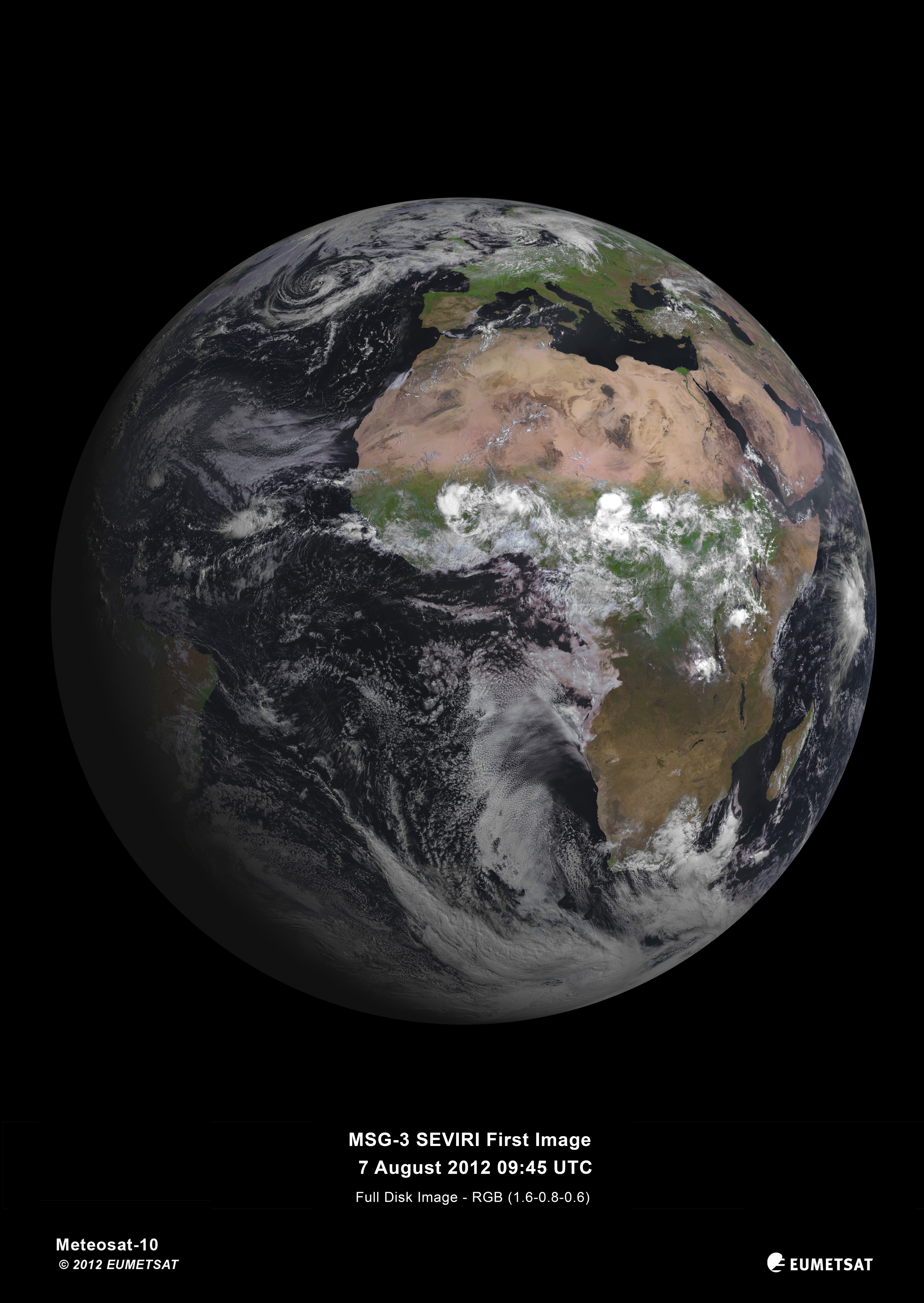
 MSG-3 first image of Earth, acquired on 7 August 2012 by its Spinning Enhanced Visible and Infrared Imager (SEVIRI). 
Credits: Eumetsat

PR 25 2012 – El instrumento SEVIRI de MSG-3 tomó ayer su primera imagen de la Tierra. Esta fotografía demuestra que el nuevo satélite meteorológico europeo en órbita geoestacionaria, lanzado el pasado día 5 de julio, funciona correctamente y avanza según lo previsto en los preparativos para su entrada en servicio.

La Agencia Espacial Europea (ESA) fue la responsable de las operaciones iniciales tras el lanzamiento de MSG-3, una fase conocida como LEOP (Lanzamiento y Operaciones Iniciales). Tras completarla con éxito, la Agencia transfirió el control del satélite a EUMETSAT el pasado día 16 de julio.
Esta primera imagen de SEVIRI es un logro conjunto de la ESA, de EUMETSAT y de la industria espacial europea. Dentro de sus programas obligatorios, EUMETSAT recurre a la ESA para el desarrollo de nuevos satélites y para la contratación de nuevas unidades de una misma serie, como es el caso de MSG-3. Este modelo de cooperación ha convertido a Europa en el líder mundial de la meteorología por satélite, al aprovechar de forma eficaz la experiencia y el conocimiento acumulado por cada una de estas dos agencias.  

Meteosat de Segunda Generación

MSG es un programa conjunto de la ESA y de EUMETSAT. La ESA es la responsable del desarrollo de los satélites, cumpliendo con los requisitos de los usuarios y los del sistema, definidos por EUMETSAT, y de la contratación de nuevas unidades en nombre de este último. La ESA lleva a cabo las operaciones de la fase LEOP, necesaria para posicionar al satélite en órbita geoestacionaria, antes de transferir su control a EUMETSAT.
EUMETSAT desarrolla todos los sistemas de tierra necesarios para procesar los datos y generar productos y servicios que respondan a las necesidades de los usuarios, en continua evolución. Esta organización es también la responsable de la contratación de los servicios de lanzamiento y de las operaciones rutinarias del sistema.
MSG-3 es el tercero en una serie de cuatro satélites, cuyo primer lanzamiento tuvo lugar en el año 2002. Todos estos satélites, estabilizados por rotación sobre su propio eje, están equipados con el instrumento SEVIRI (Spinning Enhanced Visible and Infrared Imager). El contratista principal para el desarrollo de los satélites ha sido Thales Alenia Space, mientras que el del instrumento SEVIRI fue Astrium.
SEVIRI proporciona una mejor cobertura meteorológica sobre Europa y África, lo que ayudará a mejorar las predicciones a corto plazo, detectando fenómenos de rápida evolución como las tormentas o los bancos de niebla. Este instrumento escanea la superficie de la Tierra y la atmósfera en 12 bandas espectrales una vez cada 15 minutos, lo que le permite monitorizar la evolución de las nubes.
SEVIRI puede identificar detalles de tan sólo un kilómetro en las bandas de la luz visible, y de tres kilómetros en el infrarrojo.
Además de su misión de observación meteorológica y de recogida de datos climáticos, MSG-3 transporta dos cargas útiles secundarias. El sensor GERB (Geostationary Earth Radiation Budget) medirá la cantidad de energía solar que refleja la Tierra y la radiación infrarroja emitida por nuestro propio planeta, para comprender mejor los procesos climáticos.
Un transpondedor de Búsqueda y Salvamento convertirá a MSG-3 en un repetidor de las señales de auxilio emitidas por balizas de emergencia.
Los satélites MSG han sido construidos en Cannes, Francia, por un consorcio industrial europeo liderado por Thales Alenia Space Francia, en el que participan más de 50 subcontratas de 13 países europeos.
El último satélite de la serie, MSG-4, se lanzará en 2015.
 

La Agencia Espacial Europea

La Agencia Espacial Europea (ESA) es la puerta de Europa al espacio.
La ESA es una organización intergubernamental, creada en 1975 con la misión de coordinar el desarrollo de la capacidad espacial europea y de garantizar que la inversión en el sector espacial se traduzca en beneficios para los ciudadanos de Europa, y del mundo en general.
La ESA está compuesta por 19 Estados Miembros: Alemania, Austria, Bélgica, Dinamarca, España, Finlandia, Francia, Grecia, Irlanda, Italia, Luxemburgo, Noruega, Países Bajos, Portugal, Reino Unido, República Checa, Rumanía, Suecia y Suiza, de los cuales 17 también son miembros de la Unión Europea. La ESA tiene Acuerdos de Cooperación con otros nueve miembros de la UE, y está negociando un nuevo acuerdo con el décimo (Bulgaria). Polonia está en proceso de convertirse en el Estado número 20 de la ESA. Canadá participa en algunos de los programas de la ESA a través de un Acuerdo de Cooperación.
Al coordinar los recursos económicos e intelectuales de sus miembros, la ESA puede emprender programas y actividades que quedarían fuera del alcance individual de cualquier país europeo.
La ESA desarrolla los lanzadores, los satélites y la infraestructura de tierra necesaria para mantener a Europa en la vanguardia de las actividades espaciales.
La Agencia Espacial Europea lanza satélites para la observación de la Tierra, para la navegación, las telecomunicaciones y la astronomía, envía sondas a los confines del Sistema Solar y colabora en la exploración tripulada del espacio.
Para más información:
Oficina de Relaciones con los Medios de la ESA
Departamento de Comunicación
Tel: +33 1 53 69 72 99
Fax: +33 1 53 69 76 90
 

EUMETSAT

La Organización Europea para la Explotación de los Satélites Meteorológicos es una organización intergubernamental con sede en Darmstadt, Alemania, compuesta por 26 Estados Miembros (Alemania, Austria, Bélgica, Croacia, Dinamarca, Eslovenia, España, Finlandia, Francia, Grecia, Hungría, Irlanda, Italia, Letonia, Luxemburgo, Noruega, Países Bajos, Polonia, Portugal, Reino Unido, República Checa, República Eslovaca, Rumanía, Suecia, Suiza y Turquía) y por cinco Estados Colaboradores (Bulgaria, Estonia, Islandia, Lituania y la República de Serbia).
EUMETSAT es la responsable de las operaciones de los satélites meteorológicos Meteosat-8 y -9, con cobertura sobre Europa y África, y de Meteosat-7, sobre el Océano Índico.
MetOp-A, el primer satélite meteorológico europeo en órbita polar, fue lanzado en octubre de 2006 y lleva oficialmente en servicio desde el 15 de mayo de 2007.
El satélite de altimetría oceánica Jason-2, puesto en órbita el 20 de junio de 2008, aporta al catálogo de servicios que proporciona EUMETSAT la capacidad de monitorizar el estado de la mar, las corrientes oceánicas y los cambios del nivel del mar.
Los datos y los productos generados por los satélites de EUMETSAT son fundamentales para la predicción meteorológica y constituyen una importante contribución para la monitorización del medio ambiente y del clima del planeta.
Relaciones con los Medios
EUMETSAT
Tel: +49 6151 807 7320
Fax: +49 6151 807 7321
press@eumetsat.int
www.eumetsat.int
ESA
Guillermo Gonzalo Sánchez Achutegui
ayabaca@gmail.com
ayabaca@hotmail.com
ayabaca@yahoo.com
 Inscríbete en el Foro del blog y participa : A Vuelo De Un Quinde - El Foro!

martes, 7 de agosto de 2012

Astronomy: printer friendly page MSG-3, Europe’s latest weather satellite, delivers first image

Hi My Friends: A VUELO DE UN QUINDE EL BLOG., Today, the Spinning Enhanced Visible and Infrared Imager (SEVIRI) instrument on MSG-3 captured its first image of the Earth. This demonstrates that Europe’s latest geostationary weather satellite, launched on 5 July, is performing well and is on its way to taking over operational service after six months of commissioning.

Download:
 MSG-3 first image of Earth, acquired on 7 August 2012 by its Spinning Enhanced Visible and Infrared Imager (SEVIRI). 
Credits: Eumetsat

PR 25 2012 - Today, the Spinning Enhanced Visible and Infrared Imager (SEVIRI) instrument on MSG-3 captured its first image of the Earth. This demonstrates that Europe’s latest geostationary weather satellite, launched on 5 July, is performing well and is on its way to taking over operational service after six months of commissioning.

The European Space Agency (ESA) was responsible for the initial operations after launch (the so-called launch and early orbit phase) of MSG-3 and handed over the satellite to EUMETSAT on 16 July.
The first image is a joint achievement by ESA, EUMETSAT, and the European space industry. For its mandatory programmes, EUMETSAT relies on ESA for the development of new satellites and the procurement of recurrent satellites like MSG-3. This cooperation model has made Europe a world leader in satellite meteorology by making best use of the respective expertise of the two agencies.  

About Meteosat Second Generation

MSG is a joint programme undertaken by ESA and EUMETSAT. ESA is responsible for the development of satellites fulfilling user and system requirements defined by EUMETSAT and of the procurement of recurrent satellites on its behalf. ESA also performs the Launch and Early Orbit Phase operations required to place the spacecraft in geostationary orbit, before handing it over to EUMETSAT for exploitation.
EUMETSAT develops all ground systems required to deliver products and services to users and to respond to their evolving needs, procures launch services and operates the full system for the benefit of users.
MSG-3 is the third in a series of four satellites introduced in 2002. These spin-stabilised satellites carry the primary Spinning Enhanced Visible and Infrared Imager, or SEVIRI. The prime contractor for the MSG satellites is Thales Alenia Space, with the SEVIRI instrument built by Astrium.
SEVIRI delivers enhanced weather coverage over Europe and Africa in order to improve very short range forecasts, in particular for rapidly developing thunder storms or fog. It scans Earth’s surface and atmosphere every 15 minutes in 12 different wavelengths, to track cloud development.
SEVIRI can pick out features as small as a kilometre across in the visible bands, and three kilometres in the infrared.
In addition to its weather-watching mission and collection of climate records, MSG-3 has two secondary payloads.
The Geostationary Earth Radiation Budget sensor measures both the amount of solar energy that is reflected back into space and the infrared energy radiated by the Earth system, to better understand climate processes.
A Search & Rescue transponder will turn the satellite into a relay for distress signals from emergency beacons.
The MSG satellites were built in Cannes, France, by a European industrial team led by Thales Alenia Space, France. More than 50 subcontractors from 13 European countries are involved.
The last of the series, MSG-4, is planned for launch in 2015.
 

About the European Space Agency

The European Space Agency (ESA) is Europe’s gateway to space.
ESA is an intergovernmental organisation, created in 1975, with the mission to shape the development of Europe’s space capability and ensure that investment in space delivers benefits to the citizens of Europe and the world.
ESA has 19 Member States: Austria, Belgium, the Czech Republic, Denmark, Finland, France, Germany, Greece, Ireland, Italy, Luxembourg, the Netherlands, Norway, Portugal, Romania, Spain, Sweden, Switzerland and the United Kingdom, of whom 17 are Member States of the EU. ESA has Cooperation Agreements with nine other Member States of the EU and is negotiating an Agreement with the one remaining (Bulgaria). Poland is in the process of becoming ESA’s 20th Member State. Canada takes part in some ESA programmes under a Cooperation Agreement.
By coordinating the financial and intellectual resources of its members, ESA can undertake programmes and activities far beyond the scope of any single European country.
ESA develops the launchers, spacecraft and ground facilities needed to keep Europe at the forefront of global space activities. Today it launches satellites for Earth observation, navigation, telecommunications and astronomy, sends probes to the far reaches of the Solar System and cooperates in the human exploration of space.
For further information, please contact:
ESA Media Relations Office
Communication Department
Tel: +33 1 53 69 72 99
Fax: +33 1 53 69 76 90
 

About EUMETSAT

The European Organisation for the Exploitation of Meteorological Satellites is an intergovernmental organisation based in Darmstadt, Germany, currently with 26 European Member States (Austria, Belgium, Croatia, Czech Republic, Denmark, Finland, France, Germany, Greece, Hungary, Ireland, Italy, Latvia, Luxembourg, the Netherlands, Norway, Poland, Portugal, Romania, Slovakia, Slovenia, Spain, Sweden, Switzerland, Turkey and the United Kingdom) and five Cooperating States (Bulgaria, Estonia, Iceland, Lithuania, and Serbia).
EUMETSAT operates the geostationary satellites Meteosat-8 and -9 over Europe and Africa, and Meteosat-7 over the Indian Ocean.
Metop-A, the first European polar-orbiting meteorological satellite, was launched in October 2006 and has been delivering operational data since 15 May 2007.
The Jason-2 ocean altimetry satellite, launched on 20 June 2008, added monitoring of sea state, ocean currents and sea level change to the missions EUMETSAT conducts.
The data and products from EUMETSAT’s satellites are vital to weather forecasting and make a significant contribution to the monitoring of environment and the global climate.
Media Relations
EUMETSAT
Tel: +49 6151 807 7320
Fax: +49 6151 807 7321
press@eumetsat.int
www.eumetsat.int
ESA
Guillermo Gonzalo Sánchez Achutegui
ayabaca@hotmail.com
ayabaca@gmail.com
ayabaca@yahoo.com 
 Inscríbete en el Foro del blog y participa : A Vuelo De Un Quinde - El Foro!

Mi lista de blogs