Mostrando entradas con la etiqueta Wetlands. Mostrar todas las entradas

domingo, 19 de marzo de 2017

the National Science Foundation (NSF) :Westernmost, low-lying region of Louisiana coast on track to drown under sea level rise .- Región occidental, baja de la costa de Luisiana en la pista para ahogarse debajo del aumento del nivel del mar

https://www.nsf.gov/discoveries/disc_summ.jsp?cntn_id=191205&WT.mc_id=USNSF_51&WT.mc_ev=click

Little chance this shoreline can withstand accelerating rate of sea level rise, scientists say
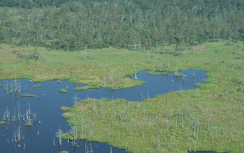
Dead trees mark an area in Houma, Louisiana, transitioning from a forested swamp to a grassy marsh.

Dead trees mark an area in Houma, Louisiana, transitioning from a forested swamp to a grassy marsh.
Credit and Larger Version

March 14, 2017
Without major efforts to rebuild Louisiana's wetlands, which serve as bulwarks against waves and rising seas, the state's coast has little chance of withstanding the accelerating rate of sea level rise, a new study concludes.
Results of the research, funded by the National Science Foundation (NSF) and conducted by scientists at Tulane University, are published in the journal Nature Communications. They show the rate of sea level rise in the region over the past six to 10 years amounting to half an inch per year, on average.
Wetlands can provide crucial protection from rising seas, especially in Louisiana's low-lying westernmost areas, but the habitats have faced years of decline, mostly from coastal erosion.
The erosion results in part from levees that have been built along the Mississippi River. The levees block mud deposits that flow to and underlie much of the Louisiana coast. The land, cut off from new building material, begins to sink.
"In the westernmost part of coastal Louisiana, many of the sites we studied are on track to drown," said Tulane geologist Torbjörn Törnqvist, co-author of the study. "This is why it is such an important setting to assess what may happen elsewhere later in this century, when global sea level rise accelerates."
That sinking is compounded by rising seas washing over fragile wetlands, further degrading them. Over time, wetland plants die, eroding the mud foundations the plants once helped support.
Törnqvist conducted the research with lead author Krista Jankowski, also of Tulane, and co-author Anjali Fernandes of the University of Connecticut.
"These researchers have developed a new way of evaluating whether coastal marshes in Louisiana will be submerged by rising sea levels," said Justin Lawrence, a program director in NSF's Division of Earth Sciences. "The findings suggest that a large portion of coastal wetlands in Louisiana are vulnerable to present-day sea level rise."
Lawrence said the research "may provide an early indication of what is to occur in coastal regions around the world later this century."
The researchers used an unconventional method of measuring sea level change that integrated information from several data sources. They analyzed measurements of shallow land subsidence, or sinking, rates at sites across the Louisiana coast and combined these with published GPS-measurements of deeper subsidence rates.
Adding published satellite observations of the sea surface in the Gulf of Mexico, they were able to calculate how rapidly sea level is rising in comparison with how quickly coastal wetlands are sinking.
"The bottom line is that in assessing how dire the situation is in Louisiana, this new dataset is a huge step forward," Törnqvist said.
The research was made possible thanks to publicly available data collected under the auspices of Louisiana's Coastal Protection and Restoration Authority and the U.S. Geological Survey.
-- Cheryl Dybas, NSF (703) 292-7734
 cdybas@nsf.gov
-- Barri Bronston, Tulane University (504) 314-7444
  bbronst@tulane.edu

Investigators Torbjörn Törnqvist
Related Institutions/Organizations Tulane University
Total Grants $132,783
Aerial view of degrading marsh in southeastern Louisiana.
Credit and Larger Version
Surface-elevation measurement in a marsh near Myrtle Grove, Louisiana.
Credit and Larger Version
Researchers use pins resting on the wetland surface to measure its elevation relative to sea level.
Credit and Larger Version
View of relatively healthy marsh area in southeastern Louisiana with tidal channels and canals.
Credit and Larger Version
Marshes around Delacroix, Louisiana, a once-thriving community now largely abandoned.
Credit and Larger Version
the National Science Foundation (NSF)
Guillermo Gonzalo Sánchez Achutegui
ayabaca@gmail.com
ayabaca@hotmail.com
ayabaca@yahoo.com
Inscríbete en el Foro del blog y participa : A Vuelo De Un Quinde - El Foro!

domingo, 5 de julio de 2015

National Science Foundation - Methane-eating microorganisms help regulate emissions from wetlands .- Microorganismos que se alimentan de metano ayudan a regular las emisiones de los humedales

Hola amigos: A VUELO DE UN QUINDE EL BLOG., hemos recibido información de la Fundación Nacional de Ciencias de Los Estados Unidos, que sus cientíicos han descubierto que microorganismos que se alimentan del metano ayudan a regular las emisiones en los humedales.
NSF, nos dice: A pesar de que ocupan una pequeña fracción de la superficie de la Tierra, los humedales de agua dulce son la mayor fuente natural de metano emitido a la atmósfera. Una nueva investigación identifica un proceso inesperado que actúa como un guardián clave en la regulación de las emisiones de metano procedentes de estos ambientes de agua dulce.
Los resultados del estudio se publican esta semana en la revista Nature Communications por el biólogo Samantha Joye, de la Universidad de Georgia y colegas.
Los investigadores informan de que las altas tasas de anaeróbico (sin oxígeno) la oxidación del metano en los humedales de agua dulce reducir sustancialmente las emisiones atmosféricas de metano.

More information.....
http://www.nsf.gov/discoveries/disc_summ.jsp?cntn_id=135306&WT.mc_id=USNSF_51&WT.mc_ev=click

Without this process, methane emissions from freshwater wetlands could be 30 to 50 percent higher:
Sin este proceso, las emisiones de metano de los humedales de agua dulce podría ser de 30 a 50 por ciento más alto
Scientist in lake collecting sediment samples in Maine
Scientists collect sediment samples in Maine's Acadia National Park.
Credit and Larger Version
June 30, 2015
Though they occupy a small fraction of Earth's surface, freshwater wetlands are the largest natural source of methane emitted into the atmosphere. New research identifies an unexpected process that acts as a key gatekeeper in regulating methane emissions from these freshwater environments.
The study results are published this week in the journal Nature Communications by biologist Samantha Joye of the University of Georgia and colleagues.
The researchers report that high rates of anaerobic (no oxygen) methane oxidation in freshwater wetlands substantially reduce atmospheric emissions of methane.

New attention

The process of anaerobic methane oxidation was once considered insignificant in freshwater wetlands, but scientists now think very differently about its importance.
"Some microorganisms actually eat methane, and recent decades have seen an explosion in our understanding of the way they do this," says Matt Kane, program director in the National Science Foundation's Division of Environmental Biology, which funded the research. "These researchers demonstrate that if it were not for an unusual group of methane-eating microbes that live in freshwater wetlands, far more methane would be released into the atmosphere."
Although anaerobic methane oxidation in freshwater has been gathering scientific attention, the environmental relevance of this process was unknown until recently, Joye says.
"This paper reports a previously unrecognized sink for methane in freshwater sediments, soils and peats: microbially-mediated anaerobic oxidation of methane," she says. "The fundamental importance of this process in freshwater wetlands underscores the critical role that anaerobic oxidation of methane plays on Earth, even in freshwater habitats."
Without this process, Joye says, methane emissions from freshwater wetlands could be 30 to 50 percent greater.

Comparison of wetlands

The researchers investigated the anaerobic oxidation process in freshwater wetlands in three regions: the freshwater peat soils of the Florida Everglades; a coastal organic-rich wetland in Acadia National Park, Maine; and a tidal freshwater wetland in coastal Georgia.
All three sites were sampled over multiple seasons.
The anaerobic oxidation of methane was coupled to some extent with sulfate reduction. Rising sea levels, for example, would result in increased sulfate, which could fuel greater rates of anaerobic oxidation.
Similarly, with saltwater intrusion into coastal freshwater wetlands, increasing sulfate inhibits microbial methane formation, or methanogenesis.
So while freshwater wetlands are known to be significant methane sources, their low sulfate concentrations previously led most researchers to conclude that anaerobic oxidation of methane was not important in these regions.

Crucial process

The new findings show that if not for the anaerobic methane oxidation process, freshwater environments would account for an even greater portion of the global methane budget.
"The process of anaerobic oxidation of methane in freshwater wetlands appears to be different than what we know about this process in marine sediments," Joye says. "There could be unique biochemistry at work."
Adds Katherine Segarra, an oceanographer at the U.S. Department of the Interior's Bureau of Ocean Energy Management and co-author of the paper: "This study furthers the understanding of the global methane budget, and may have ramifications for the development of future greenhouse gas models."
Additional financial support for the research was provided by the Deutsche Forschungsgemeinschaft via the Research Center/Cluster of Excellence at the MARUM Center for Marine Environmental Sciences and department of geosciences at the University of Bremen, Germany.
--  Cheryl Dybas, NSF (703) 292-7734 cdybas@nsf.gov
--  Alan Flurry, University of Georgia (706) 542-3331 aflurry@uga.edu
Investigators
Samantha Joye
Christof Meile
Vladimir Samarkin

Related Institutions/Organizations University of Georgia Research Foundation Inc

Related Awards #0717189 Temperature Driven Decoupling of Carbon Cycling in Freshwater Sediments and the Relative Production and Flux of Methane Versus Carbon Dioxide

Total Grants $672,990
  freshwater wetlands in Acadia National Park
Acadia National Park is dotted with freshwater wetlands.
Credit and Larger Version
wetlands covered in ice and snow.
Same wetland as above, covered in ice and snow. Researchers are studying what goes on beneath.
Credit and Larger Version
Woman sampling the overlying water of a frozen wetland in Acadia National Park.
Researchers sample the overlying water of a frozen wetland in Acadia National Park.
Credit and Larger Version
View from an airboat used to collect samples in the Florida Everglades.
Scientists use an airboat to collect samples in the Florida Everglades.
Credit and Larger Version
Freshwater wetland in coastal Georgia during  winter
Researchers collected samples from freshwater wetlands in coastal Georgia during a winter trip.
Credit and Larger Version
The National Science Foundation (NSF)
Guillermo Gonzalo Sánchez Achutegui
ayabaca@gmail.com
ayabaca@hotmail.com
ayabaca@yahoo.com
Inscríbete en el Foro del blog y participa : A Vuelo De Un Quinde - El Foro!

viernes, 6 de diciembre de 2013

nsf.gov - National Science Foundation - Wetlands' ability to overcome sea level rise threatened

When do wetlands reach their limit, and how are we lowering that point?
a tidal marsh in Chesapeake Bay
On this tidal marsh in Chesapeake Bay, wetlands and people have co-existed for millennia.
Credit and Larger Version
December 4, 2013
Left to themselves, coastal wetlands can resist rapid sea level rise.
But humans could be sabotaging some of wetlands' best defenses, according to results published in this week's issue of the journal Nature.
Thanks to an intricate system of feedbacks, wetlands are remarkably good at building up soils to outpace sea level rise. The questions are: When do they reach their limit, and how have we lowered that point?
Without human-caused climate change, "we wouldn't be worried about wetlands surviving the rates of sea level rise we're seeing today," says lead paper author Matthew Kirwan of the Virginia Institute of Marine Science and the National Science Foundation (NSF) Virginia Coast Reserve Long-Term Ecological Research (LTER) site.
Virginia Coast Reserve is one of 26 such NSF LTER sites around the globe in ecosystems from deserts to mountains and marshes to grasslands.
In an unchanged world, "wetlands would build vertically at faster rates," says Kirwan, "or move inland to higher elevations."
The paper's co-author is Patrick Megonigal of the Smithsonian Environmental Research Center.
A wetland is land that's saturated with water, whether permanently or seasonally. The water found in wetlands can be saltwater, freshwater or brackish water. Main wetland types include swamps, marshes, bogs and fens.
Wetlands have developed several ways to build elevation to keep from drowning.
Aboveground, tidal flooding provides one of the biggest assists. When marshes flood during high tides, sediment settles out of the water, adding new soil. As sea level rises and flooding occurs more often, marshes react by building soil faster.
Belowground, the growth and decay of plant roots add organic matter.
Even erosion can work in wetlands' favor, as sediment lost at one marsh may be deposited in another. While a particular wetland may lose ground, the total wetland area may remain unchanged.
But, if a wetland becomes so submerged that its vegetation dies off, these "positive feedback loops" are lost. Similarly, if sediment delivery to a wetland is cut off, that wetland can no longer build soil to outpace rising seas.
"This study reveals the complex, long-term interplay among processes that maintain coastal wetlands in the face of sea level rise," says Saran Twombly, program director in NSF's Division of Environmental Biology, which funds the NSF Virginia Coast Reserve LTER site.
"Humans are newcomers to this delicate balance. The future of a habitat so essential to human well-being depends on how severely we alter it."
For example, groundwater withdrawal and artificial drainage can cause the land to sink, as is happening in Chesapeake Bay.
Because of this subsidence, eight of the world's 20 largest coastal cities have relative sea level rise greater than climate change projections.
Dams and reservoirs also prevent 20 percent of the global sediment load from reaching the coast.
Marshes on the Yangtze River Delta, for example, have survived a relative sea level rise of more than 50 millimeters per year since the 7th century--until the recent building of more than 50,000 dams cut off the supply of sediment and accelerated erosion.
"Tidal marshes are amazing ecosystem engineers that can raise themselves upward if they remain healthy, especially if there is sediment in the water," says Megonigal.
"We know there are limits, however. Those limits are changing as people alter the environment."
-NSF-
Media Contacts Cheryl Dybas, NSF (703) 292-7734 cdybas@nsf.gov
Dave Malmquist, Virginia Institute of Marine Science (804) 684-7011 davem@vims.edu
Kristen Minogue, Smithsonian Environmental Research Center (443) 482-2325 minoguek@si.edu
Related WebsitesNSF Long-Term Ecological Research Network:
 http://www.lternet.edu
NSF Virginia Coast Reserve LTER Site:
http://www.lternet.edu/sites/vcr
NSF Publication: Discoveries in Long-Term Ecological Research:
The National Science Foundation (NSF) is an independent federal agency that supports fundamental research and education across all fields of science and engineering. In fiscal year (FY) 2012, its budget was $7.0 billion. NSF funds reach all 50 states through grants to nearly 2,000 colleges, universities and other institutions. Each year, NSF receives about 50,000 competitive requests for funding, and makes about 11,500 new funding awards. NSF also awards about $593 million in professional and service contracts yearly.
Useful NSF Web Sites:
NSF Home Page:
 http://www.nsf.gov/news/
For the News Media:
 http://www.nsf.gov/news/newsroom.jsp
Science and Engineering Statistics:
Scientist Matthew Kirwan doing research in Chesapeake Bay wetlands.
Scientist Matthew Kirwan conducts field research in Chesapeake Bay wetlands.
Credit and Larger Version
Salt marsh  with a tidal creek at NSF's Plum Island Ecosystems LTER site in Massachusetts.
Salt marsh "dissected" by a tidal creek at NSF's Plum Island Ecosystems LTER site in Massachusetts.
Credit and Larger Version
High-elevation marsh at the Plum Island Ecosystems LTER site.
High-elevation marsh at the Plum Island Ecosystems LTER site; flood-tolerant vegetation rules.
Credit and Larger Version
A fishing camp along Falgout Canal Bayou, Louisiana, where marsh has been flooded by seawater.
A fishing camp along Falgout Canal Bayou, La., where marsh has been flooded by seawater.
Credit and Larger Version
a Massachusetts marsh
Some Massachusetts marshes formed after European settlement; deforestation increased sedimentation.
Credit and Larger Version
 
 
The National Science Foundation (NSF)
Guillermo Gonzalo Sánchez Achutegui

miércoles, 18 de julio de 2012

The Earth: Satellites protect wetland areas

Hi My Friends: A VUELO DE UN QUINDE EL BLOG., Wetlands are havens of biodiversity, and have important ecological, hydrological and economic value, but their misuse can have devastating consequences. Satellite data are being used for wetland conservation and management.

 In 1977, the Ramsar Convention declared the Azraq wetland as a major station for migratory birds on the African–Eurasian flyway. Due to excessive pumping of water from the oasis and illegal drilling of wells for agricultural purposes, water levels have steadily dropped for 50 years. The wetland rescue started in 1994 with the objective to restore a significant portion of the wetland, and to increase depleted water levels by 10%. The Land Use Land Cover map of Azraq in 2005 provides a detailed classification of all land parcels within wetland sites, distinguishing between water, natural areas and artificial surfaces.
 Wetlands are havens of biodiversity, and have important ecological, hydrological and economic value, but their misuse can have devastating consequences. Satellite data are being used for wetland conservation and management.

In the arid desert of central-eastern Jordan, the Azraq oasis is the only permanent source of fresh water for about 12 000 sq km, and provides drinking water for about a quarter of the country’s capital and largest city, Amman.
Historically, the water source made Azraq a major desert route, facilitating trade in the region. It is also an important station for migratory birds on the African–Eurasian flyway.
But excessive pumping of water from the oasis and illegal drilling of wells for agricultural purposes have caused water levels to drop steadily over the past 50 years – depleting water from the wetland area.
A significant decrease of water starting in 1981 reached threatening levels in 1993, forcing many migratory birds to move away from the area. This motivated a project to rescue the wetland and increase dwindling water levels in 1994. 
 The 11th Conference of the Parties of the Ramsar Convention on Wetlands was held in Bucharest, Romania, 6–13 July 2012. The theme of the conference was ‘Wetlands: home and destination’. The Ramsar Convention on Wetlands, signed in Ramsar, Iran, in 1971, is an intergovernmental treaty that provides the political framework for international cooperation for the preservation and sustainable development of wetlands of international importance. There are 162 countries that have endorsed the Convention, with 2040 wetland sites covering a total of 193 million hectares. 
Credits: Romania, Ramsar COP-11
 To map the progress of Azraq’s rescue project, as well as monitor other wetlands worldwide, data from Earth-observing satellites are being exploited to map the areas’ water, natural land and artificial surfaces in high detail.
The further development of internationally coordinated actions for the conservation and sustainable use of wetlands came into focus last week at the 11th Conference of the Parties (COP-11) of the Ramsar Convention on Wetlands held in Bucharest, Romania.
Wetlands are havens of biodiversity and have an inestimable ecological value as habitat for various wild animals such as migratory birds.
They have an important hydrological value through their natural drainage systems which can also act as a protection dam to cope with droughts and excessive water during the rainy seasons such as floods.
 Change detection map, comparing national park of Ichkeul lies between the Mogods mountains and the Mediterranean coast of northwest Tunisia in 1972 and 1990. Earth observation data archives, with imagery acquired from the 1970s, are a unique source of information to assess the historical evolution of wetlands worldwide. This lake–marsh ecosystem has been classified as a Biosphere Reserve in 1977, included in the Ramsar list in 1980 and subsequently nominated as a World Heritage site. The prolonged droughts and the reduction of freshwater inflows due to the construction of three dams on the incoming rivers have resulted in a destructive increase of salinity and sediments and in the loss of freshwater plant species. Following the success of some extensive restoration work, the lake has been removed from the UNESCO list of World heritages in danger in 2006. 
Credits: GlobWetland II project team, ANPE (Tunisia)
 Wetlands are also an economic value for water resource development, fishery industry and ecological tourism, and a social value such as poverty eradication through the supply of water and food to local population.
In the recent years, the use of satellite Earth observations with innovative geospatial analysis has proved to be a key tool and unique information source to support the environmental community in different application domains, including wetlands conservation and management.
Part of the Ramsar strategic plan is to develop a Global Wetlands Observing System (GWOS) that would allow an increase in the accessibility of data and information on wetlands and reporting on changes in wetlands status, worldwide.
In response, ESA launched the GlobWetland II project as a GWOS regional pilot project in the southern Mediterranean basin.
The project’s principal objective was to develop a software – or ‘toolbox’ – that can be used by all Ramsar Parties to assess and monitor their wetlands with satellite images.

More than 2000 GlobWetland II maps and indicators have been produced on 200 wetland sites selected in the coastal river catchment in ten countries along the Southern Mediterranean Basin, from Morocco to Syria. Credits: GlobWetland II project, Google Earth
 Over 2000 wetland-related maps and indicators have been produced by the project on 200 wetland sites and surrounding areas of the Southern Mediterranean basin, extending from Morocco to Syria.
The GlobWetland II toolbox and database have already been installed in five of the project’s ten countries, with dedicated training sessions in Jordan (with the participation of Libya and Lebanon), Algeria and Tunisia.
At COP-11, ESA organised a side event to present the GW-II toolbox and products, and to show how their use is being extended to other wetlands in the Mediterranean basin by the Tour du Valat wetlands research centre, host of the Mediterranean Wetlands Observatory.
Participants at the side event acknowledged the ESA’s efforts and resources in promoting and demonstrating the benefits of Earth observation technology for the Ramsar Convention, and in developing a toolbox that can be used by the Contracting Parties.
ESA
Guillermo Gonzalo Sánchez Achutegui
ayabaca@gmail.com
ayabaca@hotmail.com
ayabaca@yahoo.com 
 Inscríbete en el Foro del blog y participa : A Vuelo De Un Quinde - El Foro!

Mi lista de blogs