Mostrando entradas con la etiqueta the Copernicus Sentinel satellites. Mostrar todas las entradas

lunes, 8 de mayo de 2017

ESA : URBAN MONITORING BOOSTED BY NEW DATA PROCESSOR .- El monitoreo urbano impulsado por el nuevo procesador de datos

http://www.esa.int/Our_Activities/Observing_the_Earth/Urban_monitoring_boosted_by_new_data_processor
TimeScan product: Germany
4 April 2017


A new processing tool has been developed to bundle information contained in large amounts of satellite data, paving the way for the wealth of Copernicus Sentinel satellite data to be more easily incorporated into online environment-monitoring services.
ESA’s online Urban Thematic Exploitation Platform (U-TEP) makes information from satellite data available for the non-expert user for urban environment monitoring.
To do this, it processes hundreds of terabytes of data gathered by Earth-observing satellites, and translates them into easy-to-use products for scientists, urban planners and decision-makers.
U-TEP reached a milestone recently with the integration of some 450 000 scenes from the US Landsat-8 mission acquired between 2013 and 2015. The 500 TB was reduced to about 25 TB thanks to the TimeScan processor developed by the DLR German Aerospace Center. The resulting TimeScan Landsat 2015 product is already available on the U-TEP geobrowser.
This novel tool that distils a single information product from a multitude of satellite scenes is a step towards more efficient access, processing and analysis of the massive amount of high-resolution image data provided by the latest satellites.
The Copernicus Sentinel satellites, for example, are supplying an unprecedented wealth of measurements. By the end of 2017, the operational Sentinel-1, -2 and -3 satellites alone will continuously collect a daily volume of about 20 TB of open and free satellite imagery.

TimeScan product: Pearl River Delta
In the past, users had to individually download and process data on their own computers. Now, mass data can be directly archived and processed at the point of reception for maximum speed and efficiency.
Within U-TEP, user algorithms are brought to the data where they run in cloud computing environments. This avoids the transfer of large amounts of input data and makes it unnecessary for the individual user to set up inhouse computing services.
In the near future, the TimeScan approach will be used by the U-TEP team to process both Landsat optical imagery and Sentinel-1 radar data to automatically map human settlements with unprecedented precision: 10 m resolution. This will help entities such as scientists, urban planners, environmental agencies or development banks to better understand urbanisation, as well as respond to the challenges posed by growing cities, population increase, climate change and loss of biodiversity.
The data processed by TimeScan will not only benefit urban monitoring, but also land use/land cover mapping, agriculture, forestry, the monitoring of polar and coastal regions, risk management and disaster prevention, or natural resource management.
The TimeScan processor is being used at the DLR, IT4Innovation and Brockmann Consult processing centres to create products based on Sentinel-1, Sentinel-2 and Landsat data.
U-TEP is one of six Thematic Exploitation Platforms developed by ESA to serve data user communities. These cloud-based platforms provide an online environment to access information, processing tools and computing resources for collaboration. TEPs allow knowledge to be extracted from large environmental datasets produced through Europe's Copernicus programme and other Earth observation satellites.
Urban TEP
ESA
Guillermo Gonzalo Sánchez Achutegui
Inscríbete en el Foro del blog y participa : A Vuelo De Un Quinde - El Foro!

jueves, 16 de marzo de 2017

ESA : No obstacles for airports using satellites .- No hay obstáculos para los aeropuertos que utilizan satélites...

http://www.esa.int/Our_Activities/Telecommunications_Integrated_Applications/No_obstacles_for_airports_using_satellites

                               
Ascend - Obstacle management solution

No obstacles for airports using satellites

13 March 2017
Thanks to ESA, airports can now use satellites to identify and manage obstacles that could pose a risk to flight safety. 
Of the 48 000 airports around the globe, only about a quarter can allow aircraft to land in poor weather and only 500 airports have a specialist on site to pinpoint obstacles that might exceed height restrictions within flight paths.
With ESA’s help, Ascend XYZ in Denmark has developed a service for airports to record potential obstacles. 
 
Airport restrictions

The service uses satellites and aircraft combined with smart web-based software.
“Free data from the latest Copernicus Sentinel satellites make this affordable for airports,” commented Peter Hemmingsen, CEO at Ascend. a vuelo
The service helps airports to comply with airside safety regulations. Using existing airport data, it calculates the restricted aerial zones around the airport.
“Until now, airports have used maps and a team of specialists to do these calculations but our service does this for them and outputs the correct documentation for airport authorities,” Peter added.
 
Tall trees encroaching into a restricted zone

The software is designed for use by non-specialists who can easily register and monitor obstacles penetrating restricted zones.
Sometimes a temporary obstacle, such as a crane, is erected close to the airport. This can also be registered in the Ascend software including detailed measurements supplied by the building company.
 
Registering an obstacle
 
“Using the height of the obstacle, the Ascend software can quickly calculate whether the object is a potential problem. No maps and no specialists are required. This is simple, efficient and avoids human error.”
Satnav data from Ascend guides field personnel to the obstacle and additional information can be entered offsite via the cloud- and browser-based management system.
“Through ESA, Ascend XYZ shows that using space data can improve our daily life in many different areas – in this case, it is airport safety,” notes the Agency’s Arnaud Runge.
ESA
Guillermo Gonzalo Sánchez Achutegui
ayabaca@gmail.com
ayabaca@hotmail.com
ayabaca@yahoo.com
Inscríbete en el Foro del blog y participa : A Vuelo De Un Quinde - El Foro!

sábado, 17 de septiembre de 2016

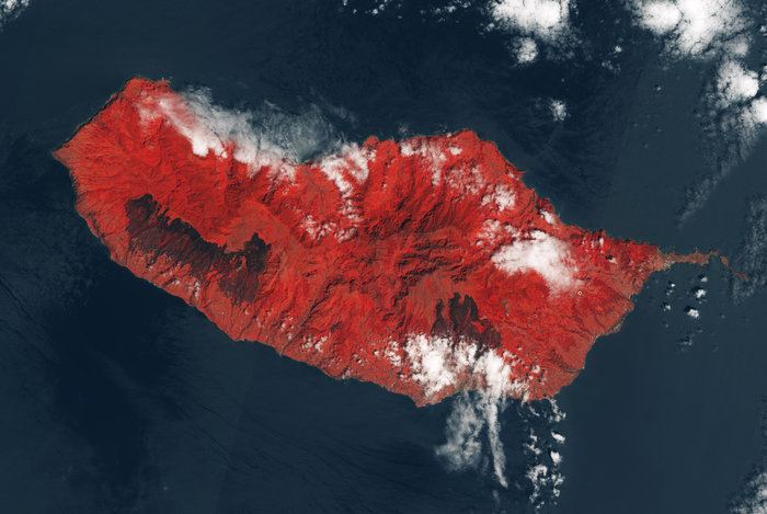
ESA : Fire-scarred Madeira .- Fuego con cicatrices en Madeira

http://www.esa.int/spaceinimages/Images/2016/09/Fire-scarred_Madeira

Details

Open/Close
  • Title Fire-scarred Madeira
  • Released 13/09/2016 5:12 pm
  • Copyright Contains modified Copernicus Sentinel data (2016), processed by ESA
  • Description This image, taken by Sentinel-2A on 17 August 2016, shows how the beautiful lush Portuguese main island of Madeira was devastated by wildfires. Madeira is famous for its rugged green landscape and is home to unique endemic flora and fauna. In fact, two thirds of the island is given over to national park to protect this natural environment.
    These ‘false-colour’ images show vegetation in red and the large black patches left by the fires where they encroached on the capital Funchal in the southeast and also broke out further to the west, leaving the land scarred.
    Carrying a high-resolution multispectral optical imager, Sentinel-2A is used to monitor changes in vegetation. This mission offers key information to optimise crop yield, thereby helping to improve food security. Data can be used to measure leaf area, leaf chlorophyll and leaf water content to monitor plant growth, which is particularly important during the growing season. It will be used to generate land-cover maps, to track changes in the way land is being used and to monitor the world’s forests.
    See animation showing Madeira before and after the wildfires.
  • Id 365163

TAGS

Open/Close

TAGS

Open/Close

  • Click on the tags to find the matching images.
  • Activity Observing the Earth
  • Mission Sentinel-2

  • ESA
    Guillermo Gonzalo Sánchez Achutegui
    ayabaca@gmail.com
    ayabaca@hotmail.com
    ayabaca@yahoo.com
    Inscríbete en el Foro del blog y participa : A Vuelo De Un Quinde - El Foro!
    viernes, 16 de septiembre de 2016

    ESA : Estonia signs up to Sentinel agreement .- Estonia se inscribe en un acuerdo con Sentinel (the Copernicus Sentinel satellites).......

    http://www.esa.int/Our_Activities/Observing_the_Earth/Copernicus/Estonia_signs_up_to_Sentinel_agreement


    Estonia

    13 September 2016 ESA and Enterprise Estonia have signed an arrangement that gives one of ESA’s newest Member States access to data from the Copernicus Sentinel satellites.
    With four Copernicus satellites – Sentinel-1A, Sentinel-1B, Sentinel-2A and Sentinel-3A – now in orbit, a wealth of complementary imagery and data is being delivered for the Copernicus services.
    Led by the EC, the Copernicus programme was put in place to manage the environment and respond to the challenges of a changing world.
    As part of the programme, ESA is responsible for the ‘space component’, which not only includes the Sentinel satellites, but also the network of receiving stations and processing centres through which data are made available for the range of Copernicus services.
    Estonia is a new ESA Member State, formally joining the Agency in September 2015.
    While data from the Sentinel satellites and missions contributing to the Copernicus programme are freely accessible for the Copernicus services, as well as to scientific and other users, the Collaborative Ground Segment Agreement signed today will facilitate Sentinel data exploitation in Estonia.
     

    Estonia signs up for Sentinel data
     
    The agreement was signed by Josef Aschbacher, ESA’s Director of Earth Observation Programmes, and Madis Võõras, Head of the Space Office Enterprise Estonia.
    It not only guarantees that Estonia has access to data, but also ensures that ESA provides technical advice on setting up data acquisition and dissemination, and makes data processing and archiving software available to national initiatives.
    Josef Aschbacher said, “We are thrilled to welcome Estonia to our expanding collaborative agreement and this is another important step for Copernicus.
    “We are looking forward to seeing the benefits this will bring to a country that is already strong in Earth observation science, applications and data processing.”
    Madis Võõras added, “Today marks an important milestone for Estonia. We have many areas of interest, such as agriculture, forestry and maritime surveillance, to name but a few, which will greatly benefit from this cooperation.” 
    Estonia is the 12th state to sign the agreement following Greece, Norway, Italy, Finland, Germany, France, UK, Sweden and Canada.
    ESA
    Guillermo Gonzalo Sánchez Achutegui
    ayabaca@gmail.com
    ayabaca@hotmail.com
    ayabaca@yahoo.com
    Inscríbete en el Foro del blog y participa : A Vuelo De Un Quinde - El Foro!

    Mi lista de blogs