Mostrando entradas con la etiqueta the Sentinel-2A satellite. Mostrar todas las entradas

domingo, 11 de septiembre de 2016

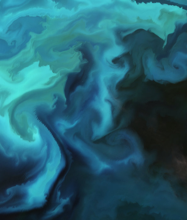
ESA : Barents bloom .- Floración de Plankton en Mar de Barents

http://www.esa.int/spaceinimages/Images/2016/08/Barents_bloom

Details

Open/Close
  • Title Barents bloom
  • Released 09/09/2016 10:00 am
  • Copyright Contains modified Copernicus Sentinel data (2016), processed by ESA
  • Description Although it may appear as a watercolour painting, this image is a natural-colour capture of a plankton bloom in the Barents Sea by the Sentinel-2A satellite.
    Plankton, the most abundant type of life found in the ocean, are microscopic marine plants that drift on or near the surface of the sea. They are sometimes referred to as ‘the grass of the sea’ because they are the basic food on which all other marine life depends.
    Since plankton contain photosynthetic chlorophyll pigments, these simple organisms play a similar role to terrestrial ‘green’ plants in the photosynthetic process. Plankton are able to convert inorganic compounds such as water, nitrogen and carbon into complex organic materials.
    With their ability to ‘digest’ these compounds, they are credited with removing as much carbon dioxide from the atmosphere as their counterparts on land. As a result, the oceans have a profound influence on climate. Since plankton are a major influence on the amount of carbon in the atmosphere and are sensitive to environmental changes, it is important to monitor and model them into calculations of future climate change.
    Although some types of plankton are individually microscopic, the chlorophyll they use for photosynthesis collectively tints the colour of the surrounding ocean waters, providing a means of detecting these tiny organisms from space with dedicated sensors, such as Sentinel-2’s multispectral imager with 13 spectral bands.
    Some algae species are toxic or harmful. If they surge out of control during optimal blooming conditions they can exhaust the water of oxygen and suffocate larger fish. This phenomenon has dramatically increased in recent decades, and is particularly dangerous to fish farms because the fish cannot flee affected areas. Early warning of harmful blooms from satellites can help to prevent fish farmers from losing their stock, as it happened in Chile recently.
    This image, also featured on the Earth from Space video programme, was captured by Sentinel-2A on 30 June.
  • Id 364568

TAGS

Open/Close

ESA

Guillermo Gonzalo Sánchez Achutegui
ayabaca@gmail.com
ayabaca@hotmail.com
ayabaca@yahoo.com
Inscríbete en el Foro del blog y participa : A Vuelo De Un Quinde - El Foro!

domingo, 4 de septiembre de 2016

ESA : Upsala Glacier .- El Glaciar Upsala en la Patagonia, Argentina....

http://www.esa.int/spaceinimages/Images/2016/08/Upsala_Glacier

Details

Open/Close
  • Title Upsala Glacier
  • Released 02/09/2016 10:00 am
  • Copyright Contains modified Copernicus Sentinel data (2016), processed by ESA
  • Description
    The Upsala Glacier in Argentina’s Los Glaciares National Park is pictured in this Sentinel-2A image from 22 January 2016.
    The park was named a UNESCO World Heritage site in 1981 and is the largest in the country, covering an area of over 7000 sq km.
    Many glaciers in the national park and in the wider Patagonian Ice Field have been retreating during the last 50 years because of rising temperatures. Upsala Glacier has retreated more than 3 km in the past 15 years.
    Glaciers are the largest reservoirs of freshwater on our planet, and their melting or growing is one of the best indicators of climate change. Satellite data can help to monitor changes in glacier mass and, subsequently, their contribution to rising sea levels. 
    Taking a closer look at the terminus of the Upsala Glacier, we can see how icebergs have broken off and are floating in the water of the upper reaches of Lake Argentino. The lake’s unique colour is attributed to ‘glacier milk’ – suspended fine sediment produced by the abrasion of glaciers rubbing against rock.
    The darker lines following the flow of the glacier are moraines: accumulations of rock, soil and other debris – including glacial milk – that have been deposited by the glacier.
    This image is also featured on the Earth from Space video programme.
  • Id 364438

TAGS

Open/Close
ESA
Guillermo Gonzalo Sánchez Achutegui
ayabaca@gmail.com
ayabaca@hotmail.com
ayabaca@yahoo.com
Inscríbete en el Foro del blog y participa : A Vuelo De Un Quinde - El Foro!

jueves, 1 de septiembre de 2016

ESA : Third Bosphorus Bridge progress .- En tercer lugar el progreso Puente del Bósforo

http://www.esa.int/spaceinimages/Images/2016/08/Third_Bosphorus_Bridge_progress

Details

Open/Close
  • Title Third Bosphorus Bridge progress
  • Released 26/08/2016 10:06 am
  • Copyright Contains modified Copernicus Sentinel data (2015–16), processed by ESA
  • Description
    These 17 images from the Sentinel-2A satellite show a year of progress on the Third Bosphorus Bridge in Istanbul, Turkey.
    Also known as the Yavuz Sultan Selim Bridge, the hybrid cable-stayed suspension bridge forms part of the ongoing 150 km-long Northern Marmara Highway project. With eight lanes of motorway and two rail lines, its 322 m A-shaped towers stand taller than the Eiffel Tower.
    The Third Bosphorus Bridge opened on 26 August 2016.
  • Id 364335

TAGS

Open/Close

ESA
Guillermo Gonzalo Sánchez Achutegui
ayabaca@gmail.com
ayabaca@hotmail.com
ayabaca@yahoo.com
Inscríbete en el Foro del blog y participa : A Vuelo De Un Quinde - El Foro!

Mi lista de blogs