Mostrando entradas con la etiqueta Storms. Mostrar todas las entradas

jueves, 8 de diciembre de 2016

The National Science Foundation (NSF) : Extreme downpours could increase 400 percent across parts of U.S..- Las lluvias extremas podrían aumentar 400 por ciento a través de partes de EE.UU.........

https://www.nsf.gov/news/news_summ.jsp?cntn_id=190537&WT.mc_id=USNSF_51&WT.mc_ev=click


A warming climate could also boost individual storm intensity
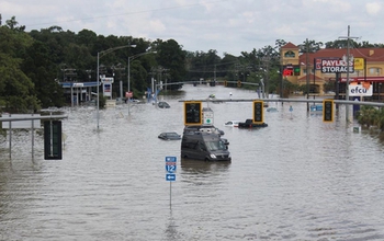
The August, 2016, floods in Baton Rouge, Louisiana, wreaked havoc throughout the area.

The August, 2016, floods in Baton Rouge, Louisiana, wreaked havoc throughout the area.
Credit and Larger Version

December 5, 2016
By century's end, the number of summertime storms that produce extreme downpours could increase by more than 400 percent across parts of the United States -- including sections of the Gulf Coast, Atlantic Coast, and the Southwest -- according to a new study funded by the National Science Foundation (NSF).
The study, by scientists at the National Center for Atmospheric Research (NCAR) and published today in the journal Nature Climate Change, also reports that the intensity of individual extreme rainfall events could increase by as much as 70 percent in some areas.
"These are huge increases," said NCAR scientist Andreas Prein, lead author of the study. "Imagine the most intense thunderstorm you typically experience in a single season. Our study finds that, in the future, parts of the U.S. could expect to experience five of those storms in a season, each with an intensity as strong, or stronger, than current storms."
Anjuli Bamzai, a program director in NSF's Geosciences Directorate, added that the research has potential public safety benefits. "Extreme precipitation events affect our infrastructure through flooding, landslides and debris flows. We need to better understand how these extreme events are changing. By supporting this research, NSF is working to foster a safer environment for all of us."

Storms and supercomputers

An increase in extreme precipitation is one of the expected effects of climate change. Scientists know that as the atmosphere warms, it can hold more water, and a wetter atmosphere can produce heavier rain. Researchers have already measured an increase in precipitation intensity across all regions of the U.S.
However, climate models are generally unable to simulate these downpours, making it difficult for researchers to assess future changes in storm frequency and intensity.
For the new study, the team used a dataset created when NCAR scientists and study co-authors Roy Rasmussen, Changhai Liu, and Kyoko Ikeda employed a Weather Research and Forecasting (WRF) model with the ability to simulate individual storms.
The simulations, which required a year to run, were performed at the NCAR-Wyoming Supercomputing Center, on a system known as Yellowstone. Prein and his co-authors used the new dataset to investigate changes in downpours over North America.
The researchers looked at how storms that happened between the years 2000 and 2013 might change if they occurred in a climate that was warmer by 5 degrees Celsius (9 degrees Fahrenheit) -- the temperature increase expected by the end of the century if greenhouse gas emissions continue unabated.
Prein cautioned that this approach is a simplified way of comparing present and future climate. It does not reflect possible changes to storm tracks or to weather systems associated with climate change.
The advantage, however, is that scientists can more easily isolate the effect of additional heat and associated moisture on future storm formation.
"The ability to simulate realistic downpours is a quantum leap in climate modeling," Prein said. "This enables us to investigate changes in hourly rainfall extremes that are related to flash flooding for the very first time. To do this took a tremendous amount of computational resources."

Effects vary

The scientists anticipate that the number of summertime storms producing extreme precipitation will increase across the entire country, although the amount varies by region.
The Midwest, for example, could have an increase of nearly 100 percent across swaths of Nebraska, the Dakotas, Minnesota, and Iowa. But the Gulf Coast, Alabama, Louisiana, Texas, New Mexico, Arizona, and Mexico could see increases ranging from 200 percent to more than 400 percent.
The study also found that the intensity of extreme rainfall events in summer could increase across nearly the entire country, with some regions, including the Northeast and parts of the Southwest, seeing particularly large increases -- in some cases more than 70 percent.
A surprising result, the scientists said, is that extreme downpours could also increase in areas that are getting drier on average, especially the Midwest.
Researchers expect the moderate rainfall events that serve as this region's major source of moisture during summer to decrease significantly, while extreme events will likely increase in frequency and intensity. This shift from moderate to intense rainfall could increase the potential for flash floods and mudslides, and would have effects on agriculture.
"Understanding how climate change may affect the environments that produce the most intense storms is essential because of the significant impacts these kinds of storms have on society," Prein said.
The study was also funded by the Research Partnership to Secure Energy for America.
-NSF-

Media Contacts Cheryl Dybas, NSF, (703) 292-7734,
cdybas@nsf.gov
Laura Snider, NCAR, (303) 497-8605,
 lsnider@ucar.edu


The National Science Foundation (NSF) is an independent federal agency that supports fundamental research and education across all fields of science and engineering. In fiscal year (FY) 2016, its budget is $7.5 billion. NSF funds reach all 50 states through grants to nearly 2,000 colleges, universities and other institutions. Each year, NSF receives more than 48,000 competitive proposals for funding and makes about 12,000 new funding awards. NSF also awards about $626 million in professional and service contracts yearly.
 Get News Updates by Email 
Useful NSF Web Sites:
NSF Home Page:
https://www.nsf.gov
NSF News:
https://www.nsf.gov/news/
For the News Media:
https://www.nsf.gov/news/newsroom.jsp
Science and Engineering Statistics:
 https://www.nsf.gov/statistics/
Awards Searches:
https://www.nsf.gov/awardsearch/
Summer storms that produce extreme downpours could increase by 400 percent across parts of the U.S.
Credit and Larger Version
Extreme downpours could increase flooding like that in Boulder, Colorado, in 2013.
Credit and Larger Version
Such extreme rainfall events result in widespread risks to infrastructure, such as roads.
Credit and Larger Version
The Boulder, Colorado, flooding of 2013 resulted in risks to life and property.
Credit and Larger Version
Highway to nowhere: Traffic along a road near Islip, New York, is stalled by heavy rains.
Credit and Larger Version
The National Science Foundation (NSF)
Guillermo Gonzalo Sánchez Achutegui
ayabaca@gmail.com
ayabaca@hotmail.com
ayabaca@yahoo.com
Inscríbete en el Foro del blog y participa : A Vuelo De Un Quinde - El Foro!

domingo, 5 de julio de 2015

NASA : NASA Takes to Kansas Skies to Study Nighttime Thunderstorms .- NASA, estudiará los cielosnocturnos de Kansas, por las tormentas nocturnas

Hola amigos: A VUELO DE UN QUINDE EL BLOG., siempre se ha sabido que para exista tormenta tiene que haber El Sol, pero en Kansas sucede todo lo contrario en sus cielos hay tormentas nocturnas; justamente la NASA ha unido a una campaña de campo de varias agencias de estudiar los sistemas de tormentas de verano en los EE.UU. Great Plains para averiguar por qué a menudo se forman después se pone el sol en lugar de durante el calor del día.

More information..... 
http://www.nasa.gov/press-release/nasa-takes-to-kansas-skies-to-study-nighttime-thunderstorms

 NASA’s DC-8 flying laboratory

NASA has joined a multi-agency field campaign studying summer storm systems in the U.S. Great Plains to find out why they often form after the sun goes down instead of during the heat of the day.
The Plains Elevated Convection at Night, or PECAN, project began June 1 and continues through mid-July. Participants from eight research laboratories and 14 universities are collecting storm data to find out how and why they form. NASA’s DC-8 airborne laboratory began research flights Tuesday from the Salina Regional Airport, Salina, Kansas.
“We’re hoping to collect measurements that will be used to characterize the atmosphere ahead of these storms,” said Richard Ferrare, senior research scientist in the Atmospheric Sciences Division at NASA’s Langley Research Center, Hampton, Virginia. “If we can map the water vapor that goes into these storms, we’ll be able to improve computer models that represent these conditions and better predict the storms.”
The NASA DC-8 and National Oceanic and Atmospheric Administration (NOAA) P-3 Orion research aircraft supporting the PECAN mission will be open to the media from 3 to 5 p.m. CDT on Saturday, July 11, at the Salina Regional Airport. The airport is located at 3237 Arnold Avenue.
Unlike other parts of the United States, summer thunderstorms across the Great Plains are most common after sunset. Much of the rain comes from medium-size weather systems and resulting thunderstorms known as mesoscale convective systems. These nighttime storms can produce heavy rainfall that contributes a significant portion of the yearly precipitation in the region.
Scientists understand that thunderstorms that form during the day result from a vertical “convective” circulation driven by rising warm air from the heated Earth’s surface and falling air cooled at higher altitudes in the atmosphere. Less well understood are the mechanisms that cause thunderstorms after the sun has gone down and the land surface has cooled.
The DC-8 carries atmospheric science instruments and investigators from Langley; NASA’s Jet Propulsion Laboratory, Pasadena, California; and several universities and research labs. NASA’s Goddard Space Flight Center in Greenbelt, Maryland, is providing a ground-based Doppler radar system.
PECAN is funded by the National Science Foundation with additional support from NASA, the National Oceanic and Atmospheric Administration (NOAA), the National Center for Atmospheric Research in Boulder, Colorado, and the Department of Energy.
In addition to the NASA and NOAA aircraft, researchers will receive data from a University of Wyoming King Air plane, ground-based instruments, weather balloons and mobile radars. Storm information will continue to be gathered from multiple agency ground and air instruments across northern Oklahoma, central Kansas, and south-central Nebraska through July.
The DC-8 is based at NASA’s Armstrong Flight Research Facility in Palmdale, California, and supports NASA’s Airborne Science Program under the Science Mission Directorate. The extended range, prolonged flight-duration capability, large payload capacity, and laboratory environment of the DC-8 make it one of the premier aircraft available for NASA Earth science investigations.
NASA researchers collect and study data from space, air, land and sea to tackle challenges facing the world today, including improved environmental prediction and natural hazard and climate change preparedness. NASA develops new ways to observe and study Earth's interconnected natural systems with long-term data records. The agency freely shares this unique knowledge and works with institutions around the world to gain new insights into how our planet is changing.
-end-
Steve Cole
Headquarters, Washington
202-358-0918
stephen.e.cole@nasa.gov
Chris Rink
Langley Research Center, Hampton, Va.
757-864-6786
chris.rink@nasa.gov
Kate Squires
Armstrong Flight Research Center, Edwards, Calif.
661-276-2020
kate.k.squires@nasa.gov
Last Updated: July 5, 2015
Editor: Karen Northon
 NASA
Guillermo Gonzalo Sánchez Achutegui
ayabaca@gmail.com
ayabaca@hotmail.com
ayabaca@yahoo.com 
 Inscríbete en el Foro del blog y participa : A Vuelo De Un Quinde - El Foro!

miércoles, 17 de julio de 2013

nsf.gov - News - Long-Buried New Jersey Seawall Spared Coastal Homes From Hurricane Sandy's Wrath

Built in 1882, then hidden by drifting sands, seawall mitigated 2012 hurricane's effects.-

Crocked house destroyed in 2012 by Hurricane Sandy in the main breach in Mantoloking, N.J.
Home destroyed in 2012 by Hurricane Sandy, in the main breach in Mantoloking, N.J.
Credit: Patrick Lynett
Download the high-resolution JPG version of the image. (2.6 MB)

Seawall dating to 1882 by the beach in Bay Head, N.J.
Relic seawall dating to 1882 in Bay Head, N.J., was uncovered by Hurricane Sandy.
Credit: Jennifer Irish
Download the high-resolution JPG version of the image. (2.4 MB)

Jennifer Irish measures Hurricane Sandy flood mark along Barnegat Bay, N.J.
Credit: Patrick Lynett
Download the high-resolution JPG version of the image. (2.1 MB)

Tow scientists walking on the beach under houses to study erosion from Sandy
Scientists Robert Weiss (left) and Patrick Lynett (right) study more than 10 feet of erosion from Sandy.
Credit: Jennifer Irish
Download the high-resolution JPG version of the image. (2.3 MB)
Houses next to the ocean destroyed by Sandy in Mantoloking, N.J.
Oceanfront homes destroyed by Sandy in Mantoloking, N.J.
Credit: Patrick Lynett
Download the high-resolution JPG version of the image. (2.7 MB)

Scientist with measuring stick checks vertical erosion at the Cupsogue Beach, N.Y.
Robert Weiss checks vertical erosion at the Cupsogue Beach, N.Y., hurricane breach.
Credit: Jennifer Irish
Download the high-resolution JPG version of the image. (2.8 MB)
Picture two residential beach communities on the New Jersey shore: Bay Head and Mantoloking. They sit side-by-side in Ocean County on a narrow barrier island that separates the Atlantic Ocean and Barnegat Bay.
Before Hurricane Sandy landed on Oct. 29, 2012, a motorist traveling north would pass through Mantoloking into Bay Head. He or she would note few changes in residential development, dunes, beaches or shoreline.
The difference, however, was hidden under the sand.
A long-forgotten, 4,134-feet-long seawall buried beneath the beach helped Bay Head weather Sandy's record storm surges and large waves, says geoscientist Jennifer Irish of Virginia Tech.
The stone structure dates to 1882. Its reappearance in 2012 surprised many area residents, underscoring the difficulties transient communities have in planning for future threats along their shores, Irish says.
"It's amazing that a seawall built nearly 150 years ago, then naturally hidden under beach sands and forgotten, would have a major effect under the conditions in which it was originally designed to perform," says H. Richard Lane, program director in the National Science Foundation's (NSF) Division of Earth Sciences.
NSF funded the research through a rapid response award following Hurricane Sandy.
"This finding should have major implications for coastal planning, as sea level rises and storms increase in intensity in response to global warming," says Lane.
The results, published online this week in the journal Coastal Engineering, illustrate the need for multi-levels of beach protection in coastal communities, Irish and colleagues say. Irish is the paper's lead author.
"Once we got to the site, we immediately saw the seawall," Irish says.
"The beach and dunes did their job to a certain point, then the seawall took over, providing significant dampening of the hurricane waves.
"It was the difference between houses that were flooded in Bay Head and houses that were reduced to piles of rubble in Mantoloking."
With recovery efforts underway and storms still circulating through the area, Irish and Robert Weiss, also a geoscientist at Virginia Tech, along with Patrick Lynett, a civil and environmental engineer at the University of Southern California, assessed the area, documenting high water marks, damage, overwash and breaches of the barrier island.
All oceanfront homes in the two boroughs were damaged, ranging from ground-floor flooding to complete destruction.
As measured by waterlines in the interiors of homes, flooding was similar in both boroughs.
The difference was the extent of the storm's effects.
In Mantoloking, an entire dune nearly vanished. Water washed over a barrier spit and opened three breaches of 541 feet, 194 feet and 115 feet, respectively, where the land was swept away.
In Bay Head, only the portion of the dune located seaward of the seawall was eroded. The section of dune behind the seawall received only minor local scouring.
Later, using Google Earth to evaluate aerial images taken two years before and immediately after Hurricane Sandy, the researchers looked at the area's houses.
They labeled a structure with a different roofline as damaged, one that no longer sits on its foundation as destroyed and the remaining houses as flooded.
The scientists classified 88 percent of the oceanfront homes in Bay Head as flooded, with just one oceanfront home destroyed.
In Mantoloking, more than half the oceanfront homes were classified as damaged or destroyed.
Despite the immense magnitude and duration of the storm, a relatively small coastal obstacle--the seawall--reduced potential wave loads by a factor of two.
The seawall was the difference between widespread destruction and minor structural effects, the researchers say.
"We are left with a clear, unintentional example," says Irish, "of the need for multiple levels of defense that include hard structures and beach nourishment to protect coastal communities."
Additional researchers include Wei Cheng and Stephanie Smallegan of Virginia Tech.
-NSF-
Media Contacts Cheryl Dybas, NSF (703) 292-7734
cdybas@nsf.gov
John Pastor, Virginia Tech (540) 231-5646
Related WebsitesNSF Award: RAPID: Observations of physical impacts following Hurricane Sandy:
The National Science Foundation (NSF) is an independent federal agency that supports fundamental research and education across all fields of science and engineering. In fiscal year (FY) 2012, its budget was $7.0 billion. NSF funds reach all 50 states through grants to nearly 2,000 colleges, universities and other institutions. Each year, NSF receives about 50,000 competitive requests for funding, and makes about 11,500 new funding awards. NSF also awards about $593 million in professional and service contracts yearly.
Useful NSF Web Sites:
NSF Home Page:
 http://www.nsf.gov
NSF News:
 http://www.nsf.gov/news/
For the News Media:
 http://www.nsf.gov/news/newsroom.jsp
Science and Engineering Statistics:
 http://www.nsf.gov/statistics/
Awards Searches:
 
Guillermo Gonzalo Sánchez Achutegui
 

Mi lista de blogs