Mostrando entradas con la etiqueta The United States of America. Mostrar todas las entradas

sábado, 26 de septiembre de 2015

NASA : Clear Skies Over the United States .- Cielos claros sobre los Estados Unidos

Hola amigos: A VUELO DE UN QUINDE EL BLOG., El 17 de septiembre de 2015, astronauta de la NASA Scott J. Kelly capta imágenes y vídeo desde la Estación Espacial Internacional durante una paso elevado de la mañana de los Estados Unidos. Compartir con sus seguidores de redes sociales, Kelly escribió: "Un cielo despejado en gran parte de los EE.UU. de hoy. #GoodMorning DeSpace_Station! #YearInSpace."
Martes, 15 de septiembre marcó el punto medio de la misión de un año a la estación espacial para Kelly y el cosmonauta ruso Mijail Kornienko. El promedio de la expedición de la Estación Espacial Internacional tiene una duración de cuatro a seis meses. Investigación habilitado por la misión de un año ayudará a los científicos a entender mejor cómo el cuerpo humano reacciona y se adapta a largo duración del vuelo espacial. Este conocimiento es fundamental ya que la NASA mira hacia misiones humanas más profundo en el sistema solar, incluyendo desde y hacia Marte, que podría durar 500 días o más.
More information.............

Lights of the United States at night photographed from the International Space Station with HTV cargo vehicle in foreground
On Sept. 17, 2015, NASA astronaut Scott Kelly captured images and video from the International Space Station during an early morning flyover of the United States. Sharing with his social media followers, Kelly wrote, "Clear skies over much of the USA today. #GoodMorning from @Space_Station! #YearInSpace."
 
Tuesday, Sept. 15 marked the midpoint of the one-year mission to the space station for Kelly and Russian cosmonaut Mikhail Kornienko. The average International Space Station expedition lasts four to six months. Research enabled by the one-year mission will help scientists better understand how the human body reacts and adapts to long-duration spaceflight. This knowledge is critical as NASA looks toward human missions deeper into the solar system, including to and from Mars, which could last 500 days or longer.
Image Credit: NASA
Last Updated: Sept. 18, 2015
Editor: Sarah Loff
NASA
Guillermo Gonzalo Sánchez Achutegui
Inscríbete en el Foro del blog y participa : A Vuelo De Un Quinde - El Foro!

martes, 26 de noviembre de 2013

NASA : Lighting the Paths Across the U.S.


Lighting the Paths Across the U.S.
Thanksgiving is a time for family, for feasting, and for gratitude in the United States. It is also a time when the nation’s transportation network is clogged with travelers. According to the American Automobile Association, an estimated 43.4 million Americans will travel 50 miles (80 kilometers) or more during Thanksgiving week, with the average round trip being 600 miles (1,000 kilometers). More than 90 percent of them will use cars or trucks, while the rest will ride planes or trains.
The United States has more roads—4.1 million miles (6.6 million kilometers)—than any other nation in the world, and roughly 40 percent more than second-ranked India. About 47,000 of those U.S. miles are part of the Interstate Highway System, established by President Dwight Eisenhower in the 1950s. The country also has 127,000 miles (204,000 kilometers) of railroad tracks and about 25,000 miles (40,000 kilometers) of navigable rivers and canals (not including the Great Lakes).
The imprint of that transportation web becomes easier to see at night. The Visible Infrared Imaging Radiometer Suite (VIIRS) on the Suomi NPP (National Polar-orbiting Partnership) satellite acquired two nighttime images early on Oct. 1, 2013, for this natural-light, mosaic view of the continental United States. The VIIRS instrument uses a “day-night band” of wavelengths that is sensitive to low light levels and manmade light sources. The images were collected just three days before the new moon, so reflected light from space and the atmosphere was relatively low. It was also a rare night when most of the nation was cloud-free.
Image Credit: NASA Earth Observatory image by Jesse Allen and Robert Simmon, using Suomi NPP VIIRS and DMSP OLS data provided courtesy of Chris Elvidge (NOAA National Geophysical Data Center)
Caption: Mike Carlowicz
NASA
Guillermo Gonzalo Sánchez Achutegui
ayabaca@gmail.com
ayabaca@hotmail.com
ayabaca@yahoo.com
Inscríbete en el Foro del blog y participa : A Vuelo De Un Quinde - El Foro!

jueves, 21 de noviembre de 2013

NASA: Celebrating Fifteen Years of the International Space Station


The space station is one of the brightest objects in the sky.
Image Credit: NASA
Feature Link:

Celebrating Fifteen Years of the International Space Station
Astronaut James H. Newman waves during a spacewalk preparing for release of the first combined elements of the International Space Station. The Russian-built Zarya module, with its solar array panel visible here, was launched into orbit fifteen years ago on Nov. 20, 1998. Two weeks later, on Dec. 4, 1998, NASA's space shuttle Endeavour launched Unity, the first U.S. piece of the complex. Endeavour's forward section is reflected in Newman's helmet visor in this image. During three spacewalks on the STS-88 mission, the two space modules built on opposite sides of the planet were joined together in space, making the space station truly international.
Since that first meeting of Zarya and Unity, the space station grew piece by piece with additions from each of the international partners built across three continents and leading to the largest and most complex spacecraft ever constructed. The space station, now four times larger than Mir and five times larger than Skylab, represents a collaboration between NASA, Roscosmos, the European Space Agency, the Japanese Aerospace Exploration Agency and the Canadian Space Agency, representing 15 countries in all.
In support of station assembly and maintenance, station and shuttle crews have conducted 174 spacewalks totaling almost 1,100 hours – the equivalent to nearly 46 days of spacewalks to build and maintain the complex. The station, with a mass of almost a million pounds and the size of a football field, is second only to the moon as the brightest object in the night sky.
Over the years, a great deal of research has been done on the space laboratory, which has already yielded tremendous results toward various fields. The science of the space station has provided benefits to humankind in areas such as human health, Earth observation and education. Many more results and benefits for both space exploration and life on Earth are expected in the coming years.
Image Credit: NASA

International Space Station Features

  • The One-Year Crew

    NASA and the Russian Federal Space Agency have named veteran spacefarers Scott Kelly and Mikhail Kornienko for a one-year mission aboard the station in 2015.
  • Take a Tour of the ISS with Suni Williams

    In her final days as commander of the International Space Station, Suni Williams recorded an extensive tour of the orbital laboratory. The tour includes scenes of each of the station's modules and research facilities.
  • A Day in the Life Aboard the Station

    Have you ever wondered what it would be like to live and work in space? Follow astronauts on the International Space Station in a series of videos as they explain their daily routines.
  • A Lab Aloft: The Space Station Research Blog

    Take a look behind-the-scenes with the scientists and researchers who are conducting experiments on board the International Space Station.
  • Destination: Station

    Destination Station promotes research opportunities, educates communities and communicates the impacts of the station on our everyday lives.

Space Station News Releases


What Is the International Space Station?
 
An artist's picture of the finished space station
The space station is one of the brightest objects in the sky.
Image Credit: NASA
Image Token:
Feature Link:

The International Space Station is a large spacecraft. It orbits around Earth. It is a home where astronauts live.

The space station is also a science lab. Many countries worked together to build it. They also work together to use it.

The space station is made of many pieces. The pieces were put together in space by astronauts. The space station's orbit is about 220 miles above Earth. NASA uses the station to learn about living and working in space. These lessons will help NASA explore space.

How Old Is the Space Station?
The first piece of the International Space Station was launched in 1998. A Russian rocket launched that piece. After that, more pieces were added. Two years later, the station was ready for people. The first crew arrived in October 2000. People have lived on the space station ever since. Over time more pieces have been added. NASA and its partners around the world finished the space station in 2011.

How Big Is the Space Station?
Three crew members pose on the space station, with one upside-down
Pictured here are members of the 17th crew to live aboard the space station.
Image Credit: NASA
Image Token:
Feature Link:
The space station is as big inside as a house with five bedrooms. It has two bathrooms, a gymnasium and a big bay window. Six people are able to live there. It weighs almost a million pounds. It is big enough to cover a football field including the end zones. It has science labs from the United States, Russia, Japan and Europe.

What Are the Parts of the Space Station?
The space station has many parts. The parts are called modules. The first modules had parts needed to make the space station work. Astronauts also lived in those modules. Modules called "nodes" connect parts of the station to each other. Labs on the space station let astronauts do research.

On the sides of the space station are solar arrays. These arrays collect energy from the sun. They turn sunlight into electricity. Robot arms are attached outside. The robot arms helped to build the space station. They also can move astronauts around outside and control science experiments.

Airlocks on the space station are like doors. Astronauts use them to go outside on spacewalks.

Docking ports are like doors, too. The ports allow visiting spacecraft to connect to the space station. New crews and visitors enter the station through the docking ports. Astronauts fly to the space station on the Russian Soyuz. The crew members use the ports to move supplies onto the station.

Why Is the Space Station Important?
An astronaut works outside a space station module
Astronauts work in spacesuits to help build the space station.
Image Credit: NASA
Image Token:
Feature Link:

The space station is a home in orbit. People have lived in space every day since the year 2000. The space station's labs are where crew members do research. This research could not be done on Earth.

Scientists study what happens to people when they live in space. NASA has learned how to keep a spacecraft working for a long time. These lessons will be important in the future.

NASA has a plan to send humans deeper into space than ever before. The space station is one of the first steps. NASA will use lessons from the space station to get astronauts ready for the journey ahead.

More About the Space Station:
› Kids Zone 3: International Space Station
› Now in Space: Who's on the Space Station?


Read What Is the International Space Station? Grades 5-8
Return to Homework Topics Grades K-4
David Hitt/NASA Educational Technology Services
 
NASA
Guillermo Gonzalo Sánchez Achutegui

martes, 16 de julio de 2013

NASA - Heat Wave Building Into the Ohio Valley and Eastern United States


Heat Wave Building Into the Ohio Valley and Eastern United States
A very anomalous weather pattern is in place over the U.S. for mid-July. Trapped between an upper level ridge centered over the Ohio Valley and the closed upper level low over the Texas/Oklahoma border, atypical hot, muggy air is stifling a broad swath of the eastern U.S. The closed low is expected to drift west toward New Mexico bringing heavy, localized rain to some areas and temperatures running 10-20 degrees below mid-July averages. Across the east, temperatures will warm well into the 90's and stay there through the week. This image was taken by the GOES East satellite at 12:45 p.m. EDT on July 15, 2013.
Image Credit: NOAA/NASA GOES Project
Caption Credit: NOAA
NASA
Guillermo Gonzalo Sánchez Achutegui
Inscríbete en el Foro del blog y participa : A Vuelo De Un Quinde - El Foro!

miércoles, 10 de julio de 2013

Science: NSF and NBC Learn Explore the Future of Water in New Video Series

"Sustainability: Water" video series examines the long-term health of one of America's most important resources.-

Sustainability water video series logo

New NSF-NBC Learn video series examines the long-term health and sustainability of water, one of Americas most important and often taken for granted resources.

Credit: NBC Universal

Download the high-resolution JPG version of the image. (250 KB)

 
The National Science Foundation (NSF) and NBC Learn (NBC News' educational arm) have teamed up to produce a new informative video series that examines the long-term health of one of America's most important resources: water.
As climate rapidly changes and population grows, providing a sufficient supply and quality of water will be a critical challenge to people everywhere. These videos aim to help advance public understanding of the effects human activity and climate variability have on water and its distribution system.
"Sustainability: Water," an original seven-part collection, consists of detailed stories explaining significant challenges to managing the water supply in selected regions and cities across the United States.
The series highlights research funded by NSF and looks at the lives of scientists who are hard at work on projects designed to help pave the way to a more sustainable future. Each video features an NSF-supported scientist from a diversity of fields, geographic locations and institutions explaining a specific challenge and how these challenges are affecting the water supply. Each episode is available cost-free to teachers, students and the public at NSF and NBCLearn.com websites.
"Most Americans take water for granted," said Roger Wakimoto, assistant director for NSF's Directorate for Geosciences. "We have occasional water restrictions, but for most of us, when we turn on the tap, water is there. This series with NBC Learn aims to help people become more conscious of the threats to our water supply and understand the steps that need to be taken to maintain it."
"Our new series with NSF is an excellent opportunity to raise awareness about the challenges to our environment," said Soraya Gage, general manager of NBC Learn. "By exploring the challenge of sustainable water, we hope to raise awareness and spur dialogue about managing the water system and conserving Earth's most precious resource."
New "Sustainability: Water" videos released today include:

1. The water cycle
This video uses animation and graphics to explain each of the "flow" and "storage" processes in the Water Cycle: precipitation, interception, run-off, infiltration, percolation, groundwater discharge, evaporation, transpiration, evapotranspiration and condensation.
2. Sustainability: Water--the Ogallala Aquifer
Farmers in Kansas and other states that sit atop the Ogallala aquifer--the largest freshwater aquifer in North America--are pumping out water for crop irrigation far faster than natural seepage of rainwater can replenish it. Scientist David Hyndman from Michigan State University is helping develop a plan to better manage this vital resource for sustainable farming.
3. Sustainability: Water--Sierra Nevada snow pack and snow melt
Snow melt from the snow pack in Sierra Nevada mountain range provides drinking water to about 30 percent of California's residents, irrigates key crops in the San Joaquin valley and runs hydroelectric power plants that supply at least 15 percent of the state's electricity. Martha Conklin and Tom Harmon of the University of California, Merced use wireless sensor technology to more accurately measure snow pack and snow melt so that state water managers can make better decisions on how to allocate this resource.
4. Sustainability: Water--dead trees and dirty water in the Rockies
The Rocky Mountains supply water to more than 60 million people in the West, but this watershed is in peril due to a tiny insect: the mountain pine beetle. Millions of trees killed by these "bark beetles" have dropped branches that once intercepted snow; snow now falls directly on the ground and runs off more quickly and contaminated by decaying tree "litterfall." Hydrologists Reed Maxwell of Colorado School of Mines and John Stednick of Colorado State University are studying the impact of the beetle-killed trees on water quantity and quality in the area.
5. Sustainability: Water--Los Angeles and water imports
The nearly 10 million people in Los Angeles, Calif., require a lot of water--most of which is imported snow melt from the Eastern Sierra Nevadas and Rocky Mountains hundreds of miles away. University of California, Los Angeles researchers Stephanie Pincetl and Mark Gold are studying how Los Angeles can reduce its water imports and better capture, store and reuse water for a more sustainable water supply.
6. Sustainability: Water--urban streams in Baltimore
The Chesapeake Bay, a natural habitat and watershed providing fresh water for Baltimore, Md., faces an environmental crisis: nitrate pollution in run-off from a range of sources. Claire Welty of the University of Maryland-Baltimore County is studying run-off through city water systems and "urban streams" in and around Baltimore, in hopes that a better understanding of the urban water cycle will help municipalities reduce or prevent watershed pollution.
7. Sustainability: Water--Lake Erie and nutrient loading
In 2011, Lake Erie suffered an unprecedented bloom of toxic blue-green algae, a concern to millions who use the lake for drinking water, agriculture, manufacturing and tourism. Stanford University's Anna Michalak, University of Toledo's Thomas Bridgeman and Heidelberg University's R. Peter Richards are among those studying how agricultural runoff, plus changes in precipitation, may increase nutrient flow into Lake Erie that can "feed" potentially dangerous algae blooms.
In addition to its subscription resources, NBC Learn also produces original video collections that are made available for free on NBCLearn.com. These include Emmy Award-winning videos produced in partnership with NSF, see:
and
-NSF-
Media Contacts Bobbie Mixon, NSF (703) 292-8070
 bmixon@nsf.gov
Brianne Beers, NBC News (212) 664-3875
The National Science Foundation (NSF) is an independent federal agency that supports fundamental research and education across all fields of science and engineering. In fiscal year (FY) 2012, its budget was $7.0 billion. NSF funds reach all 50 states through grants to nearly 2,000 colleges, universities and other institutions. Each year, NSF receives about 50,000 competitive requests for funding, and makes about 11,500 new funding awards. NSF also awards about $593 million in professional and service contracts yearly.
Useful NSF Web Sites:
NSF Home Page:
 http://www.nsf.gov
NSF News:
 http://www.nsf.gov/news/
For the News Media:
http://www.nsf.gov/news/newsroom.jsp
Science and Engineering Statistics:
 http://www.nsf.gov/statistics/
Awards Searches:
http://www.nsf.gov/awardsearch/

The National Science Foundation (NSF).

Guillermo Gonzalo Sánchez Achutegui
ayabaca@gmail.com
ayabaca@hotmail.com
ayabaca@yahoo.com
Inscríbete en el Foro del blog y participa : A Vuelo De Un Quinde - El Foro!

sábado, 29 de junio de 2013

nsf.gov : Ghosts of Forests Past: Bark Beetles Kill Lodgepole Pines, Affecting Entire Watersheds

Bark beetle epidemic changing water quality as well as forest health,
Mountain with dried trees in a forest overlooking Grand Lake, Colorado
Ghosts of a forest past: bark beetle-killed trees overlook Grand Lake, Colo.
Credit: Lindsay Bearup
Download the high-resolution JPG version of the image. (3.3 MB)
A stream going through bark beetle-felled trees
Bark beetle-felled trees fall, landing on a river and likely affecting the health of its waters.
Credit: Lindsay Bearup
Download the high-resolution JPG version of the image. (3.8 MB)
Scientists with soil and microbial samples beneath a beetle-killed tree.
Scientists take soil and microbial samples beneath a beetle-killed tree.
Credit: Thomas Cooper, Lightbox Images
Download the high-resolution JPG version of the image. (207 KB)
Beetle-killed trees line a river
Beetle-killed trees line a river; researchers have found water quality changes.
Credit: Lindsay Bearup
Download the high-resolution JPG version of the image. (4.4 MB)
Close-up of a pine with open areas in the bark created by beetle burrowing
Beetles burrowing into pines create open areas in the trees' bark.
Credit: Lindsay Bearup
Download the high-resolution 29 version of the image. (3.6 MB)
Researcher conducting experiments in a lab.
Researchers conduct experiments on the influence of chemicals in pine needles on soil.
Credit: Thomas Cooper, Lightbox Images
Download the high-resolution JPG version of the image. (150 KB)


The following is part eleven in a series on the National Science Foundation's Science, Engineering and Education for Sustainability (SEES) investment. Visit parts one, two, three, four, five, six, seven, eight, nine and ten in this series.
In mountains across the Western United States, scientists are racing against time--against a tiny beetle--to save the last lodgepole pines.
Forests are bleeding out from the effects of the beetles, their conifers' needles turning crimson before the trees die.
Now, researchers are also hurrying to preserve the region's water quality, affected by the deaths of the pines.
"When these trees die," says hydrologist Reed Maxwell of the Colorado School of Mines, "the loss of the forest canopy affects hydrology and the cycling of essential nutrients."
Maxwell and other scientists recently published results of their study in the journal Biogeochemistry.
Co-authors, in addition to Maxwell, are Kristin Mikkelson, Lindsay Bearup, John McCray and Jonathan Sharp of the Colorado School of Mines, and John Stednick of Colorado State University. Mikkelson is the paper's first author.

Bark beetle numbers: heating up
"The mountain pine beetle outbreak in Western states has reached epidemic proportions," says Maxwell.
Bark beetles, as they're known, are native to the United States. They're so-named as the beetles reproduce in the inner bark of trees. Some species, such as the mountain pine beetle, attack and kill live trees. Others live in dead, weakened or dying hosts.
Massive outbreaks of mountain pine beetles in western North America since the mid-2000s have felled millions of acres of forests from New Mexico to British Columbia, threatening increases in mudslides and wildfires.
Climate change could be to blame. The beetles' numbers were once kept in check by cold winter temperatures and trees that had plenty of water to use as a defense.
But winters have become warmer, and droughts have left trees water-stressed and less able to withstand an onslaught of winged invaders.
"A small change in temperature leads to a large change in the number of beetles--and now to a large change in water quality," says Tom Torgersen, director of the National Science Foundation's (NSF) Water, Sustainability and Climate (WSC) Program, which funded the research.
WSC is part of NSF's Science, Engineering and Education portfolio of investments.
"Bark beetles have killed 95 percent of mature lodgepole pines," says Maxwell.

Death of a lodgepole pine
But the trees don't die immediately.
When beetles invade, a blue fungus spreads inside a tree's trunk, choking off transpiration and killing the tree in about two years.
The trees turn blood-red, then the ashen gray of death, dropping their needles to the forest floor.
"Some of the most important effects of bark beetles may be changes in the hydrologic cycle," says Maxwell, "via snow accumulation under trees and water transpiration from trees and other plants."
Biogeochemical changes may be even more important, he says, with carbon and nitrogen cycles interrupted.
"We're studying these hydrologic and geochemical processes through a combination of field work, lab research and computer modeling," says Maxwell.

Whither the beetles, so the trees, forests...and waters
Changes in tree canopies affect snowpack development and snowmelt.
For example, a lack of needles on branches lets more snow fall through the canopy--snow that would otherwise be caught on branches. A tree without needles also has less shade beneath it.
The result is a shallower snowpack, earlier snowmelt and less water in spring.
"The real question," Maxwell says, "is how these processes translate from individual trees to hillslopes to large watersheds."
Dead trees don't transpire water. Once a forest has died, this important flow of moisture from the ground to the atmosphere ceases.
That can mean a loss of as much as 60 percent of the water budget, although increases in ground evaporation or transpiration from understory shrubs and bushes may compensate for some of the lack.
"Combined with what's happening to snowpack depth," says Maxwell, "it becomes a complicated relationship that can change the timing and magnitude of spring runoff from snowmelt--and an entire year's water resources."
Tree mortality also appears to affect forest carbon and nitrogen cycles through increases in dissolved organic carbon.
"We've seen changes in drinking water quality in beetle-affected watersheds that are almost certainly related to high dissolved organic carbon levels," says Maxwell.
As Maxwell, Mikkelson, Bearup and colleagues discovered, there's a lag time between beetle infestation and water quality declines, "so tree and forest water transport processes are very likely involved," says Maxwell.

All watersheds great and small

The observations prompted the researchers to study processes at the individual tree and hillslope scale to better understand what's happening in watersheds large and small.
"Watersheds are complex, interrelated systems," says Maxwell, "which makes understanding them more challenging.
"We're developing complex, numerical models of bark beetle-infested watersheds that include our best understanding of how and where water flows. The models are allowing us to isolate individual processes by turning them on and off in 'what-if' scenarios."
Along with on-the-ground observations, he says, "they're showing us more of the complex story of pine beetle effects on Western watersheds.
"We now know that healthy watersheds ultimately depend on healthy forests."
Western streams and rivers soon may be part of dead and dying forests, surrounded only by the ghosts of lodgepole pines past.

Related WebsitesNSF Science, Engineering and Education for Sustainability (SEES) Programs:
 http://www.nsf.gov/sees
NSF "Discoveries in Sustainability" Publication:
 http://www.nsf.gov/pubs/2012/disco12001/disco12001.pdf
NSF News Release: How Is Earth's Water System Linked With Land Use, Climate Change and Ecosystems?:  
NASA
Guillermo Gonzalo Sánchez Achutegui
ayabaca@gmail.com
ayabaca@hotmail.com
ayabaca@yahoo.com
Inscríbete en el Foro del blog y participa : A Vuelo De Un Quinde - El Foro!

jueves, 27 de junio de 2013

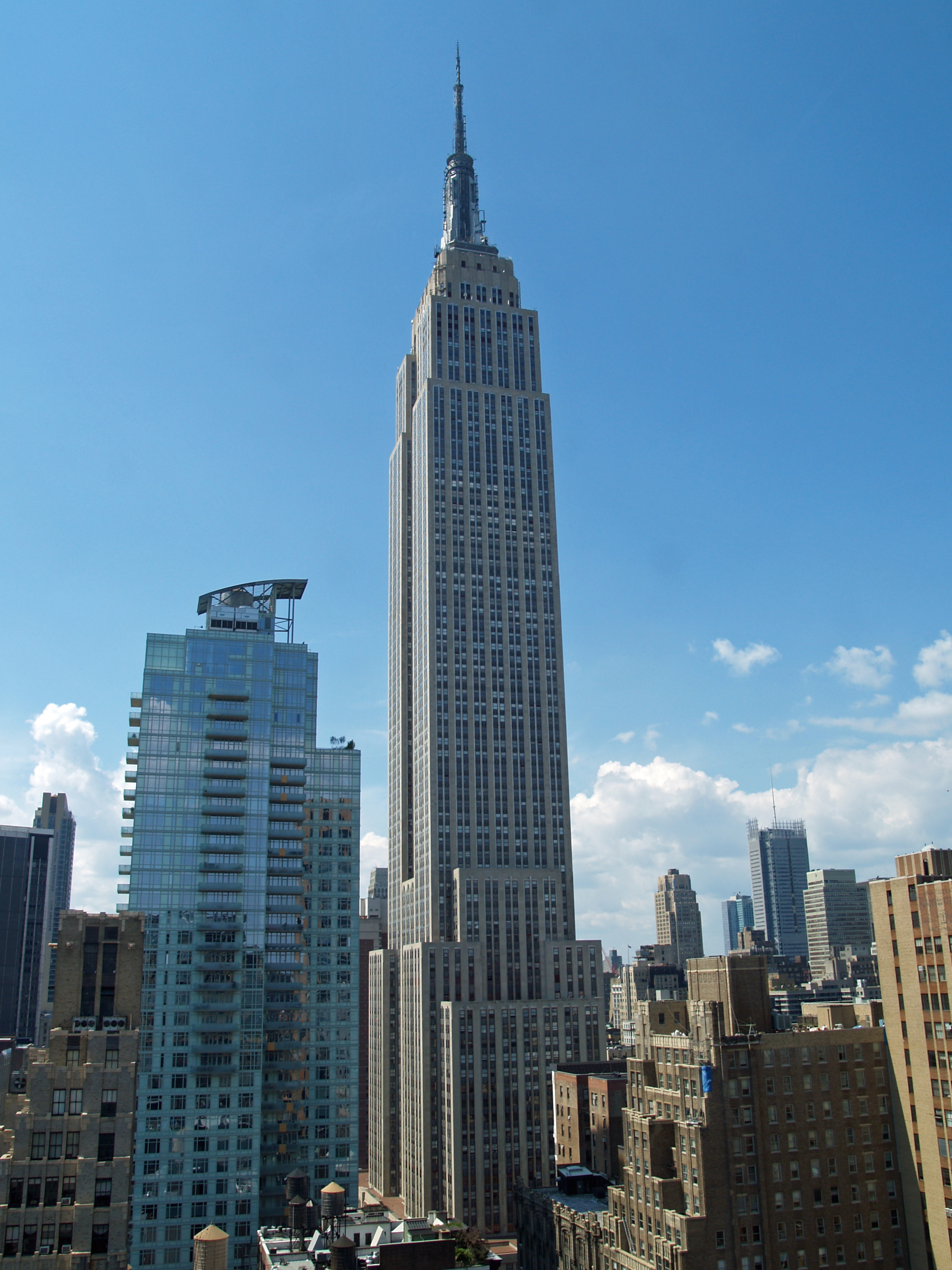
Rascacielos: El Empire State Building recibe dos multimillonarias ofertas de compra


 Full resolution(2,318 × 3,091 pixels, file size: 2.13 MB, MIME type: image/jpeg); ZoomViewer: flash/no flash
El edificio Empire State (en inglés: Empire State Building) es un rascacielos situado en la intersección de la Quinta Avenida y West 34th Street, en la ciudad de Nueva York, Estados Unidos. Su nombre deriva del apodo del Estado de Nueva York. Fue el edificio más alto del mundo durante más de cuarenta años, desde su finalización en 1931 hasta 1972, año en que se completó la construcción de la torre norte del World Trade Center. Tras la destrucción del World Trade Center el 11 de septiembre de 2001, el edificio Empire State se convirtió nuevamente en el edificio más alto de la ciudad de Nueva York y del estado de Nueva York, hasta que fue otra vez traspasado por One World Trade Center el 30 de abril de 2012 como la torre más alta de Nueva York, quedando el Empire State en segundo lugar.1
El edificio Empire State ha sido nombrado por la Sociedad Estadounidense de Ingenieros Civiles como una de las Siete Maravillas del mundo moderno. El edificio y su interior son designados monumentos de la Comisión para la Preservación de Monumentos Históricos de Nueva York, y confirmado por la Junta de Estimación de la Ciudad de Nueva York. Fue designado como un monumento Histórico Nacional en 1986. En 2007, ocupó el número uno en la lista de las edificaciones favoritas americanas y hoy día también. El edificio es propiedad y está gestionado por W & H Properties.
Wikipedia.


El Empire State Building recibe dos multimillonarias ofertas de compra
Mapa


El Empire State Building recibe dos multimillonarias ofertas de compra
Nueva York, 27 jun (EFE).- Los propietarios del Empire State Building de Nueva York han recibido dos ofertas de compra por el emblemático rascacielos, una por 2.000 millones de dólares y otra por 2.100 millones.
En un documento que se puede ver hoy en la web de la Comisión del Mercado de Valores de EE.UU., la familia Malkin, que controla el histórico inmueble, anunció que la semana pasada recibió dos propuestas de adquisición no solicitadas, aunque no detalla de quién provienen.
"Consideramos todas las opciones, incluyendo las ofertas no solicitadas", dice el documento que firman Peter y Anthony Malkin, aunque aseguran que no responderán a estas propuestas hasta que no sean analizadas.
Los Malkin han impulsado un proyecto para agrupar el rascacielos junto a otra veintena de edificios en una nueva empresa que concentre los derechos de propiedad, un fondo de inversión en bienes raíces llamado Empire State Realty Trust, y sacar esa firma a bolsa.
Tras haberse encontrado con la oposición inicial de un grupo de pequeños inversores que incluso llegó a los tribunales de Nueva York, el proyecto consiguió a finales de mayo la mayoría necesaria de votos para salir adelante y convertir el Empire State en una empresa cotizada.
Estas dos nuevas ofertas podrían evitar ese plan, aunque ninguna de ellas alcanza los alrededor de 2.500 millones de dólares a los que valoran los Malkin el famoso rascacielos neoyorquino.
Según publica hoy el diario The New York Post, detrás de la oferta de 2.100 millones está un inversor de Oriente Medio que se ha aliado con los promotores inmobiliarios estadounidenses Joe Tabak, de Princeton Holdings, y Philip Pilevsky, de Philips International.
Rubin Schron, un inversor en bienes raíces de Nueva York, estaría detrás de la otra propuesta de adquisición.
El famoso Empire State Building, de 102 pisos y situado en la Quinta Avenida a la altura de la calle 34 de Manhattan, recibe cada año unos cuatro millones de visitantes, que ascienden a lo más alto del rascacielos para contemplar desde allí las vistas de la Gran Manzana.
Guillermo Gonzalo Sánchez Achutegui
ayabaca@gmail.com
ayabaca@hotmail.com
ayabaca@yahoo.com
Inscríbete en el Foro del blog y participa : A Vuelo De Un Quinde - El Foro!

jueves, 8 de noviembre de 2012

NASA - Election Day 2012


Download Image

› Full Size

 Inscríbete en el Foro del blog y participa : A Vuelo De Un Quinde - El Foro!

domingo, 23 de septiembre de 2012

NASA: Wildland Fires in Idaho


Download Image

› Full Size 

 Inscríbete en el Foro del blog y participa : A Vuelo De Un Quinde - El Foro!

miércoles, 22 de agosto de 2012

Library of Congress: Herblock & Photographers Observe the Environment


 This service is provided by the Library of Congress at www.LOC.gov.
 ["Welwyn," Harold Irving Pratt house, 100 Crescent Beach Road, Glen Cove, New York. (LOC)
Johnston, Frances Benjamin,, 1864-1952,, photographer.
["Welwyn," Harold Irving Pratt house, 100 Crescent Beach Road, Glen Cove, New York. Rhododenron at terrace wall]
  
[George Warrington Curtis house, Southampton, New York. (LOC)
Johnston, Frances Benjamin,, 1864-1952,, photographer. [George Warrington Curtis...
Uploaded on Aug 17, 2012
  [Dr. Charles William Richardson house, Chevy Chase, Washington, D.C. (LOC)
Johnston, Frances Benjamin,, 1864-1952,, photographer. [Dr. Charles William...


News from the Library of Congress

“Down to Earth: Herblock and Photographers Observe the Environment” Opens at Library of Congress on Sept. 22

Throughout his 72-year career, Herblock, the award-winning cartoonist at the Washington Post, revealed a concern and passion for the environment. His cartoons, along with photographs on environmental issues by 12 American photographers, will be showcased in a new exhibition at the Library of Congress.
"Down to Earth: Herblock and Photographers Observe the Environment" opens on Saturday, Sept. 22 in the Graphic Arts Galleries on the ground level of the Thomas Jefferson Building, 10 First St. S.E., Washington, D.C. Free and open to the public from 8:30 a.m. to 4:30 p.m., Monday through Saturday, the exhibition closes on Saturday, March 23, 2013.
The exhibition will offer new perspectives with which to observe the planet. The cartoons and photographs on display are compelling compositions, because their creators intended to provoke reaction and inspire change.
The inspiration for "Down to Earth" comes from Herbert L. Block (1909-2001), commonly called Herblock, and his long-standing support for protecting the environment. A four-time Pulitzer Prize winner, Herblock was the chief editorial cartoonist at the Washington Post, where he worked for more than 55 years.
The exhibition features 15 Herblock cartoons and 17 photographs. Although the visual techniques used in photography and cartooning differ, both types of media can address such themes as the spread of toxins, water pollution, the negative effects of oil drilling, global warming, deforestation, exploitation of wetlands and overconsumption.
Sam Kittner’s photographs vividly document the outrage of demonstrators in Louisiana over toxic-waste dumping. Other images are more subtle, such as Olaf Otto Becker’s beautiful image of a blue river in Greenland that shows the effects of global warming and acid rain.
Herblock’s cartoons rely on humor, irony and sarcasm. One of the drawings on display, from 2001, shows two businessmen smoking cigars and looking at oil derricks on the Alaskan landscape. It is titled "We Could Compromise and Paint Them Green." Another drawing, created in 1998, shows a beleaguered man, seen through the heat waves of a blazing sun. He is carrying a coat on one arm and is holding up a newspaper with the headline "Environmental Groups Warn of Global Warming." It is titled "All Right, All Right – I Believe It."
An online version of "Down to Earth" will be available on Saturday, Sept. 22, at myloc.gov/Exhibitions/herblock-down-to-earth/.
"Down to Earth" is located in one of the three exhibition spaces of the Graphic Arts Galleries. The other spaces are the Swann Gallery and the Herblock Gallery. Currently in the Herblock Gallery is "Herblock Looks at 1962: Fifty Years Ago Today in Editorial Cartoons," which will rotate in 10 new cartoons from 1962 on Saturday, Sept. 22.
Three gallery talks about "Down to Earth" are scheduled in October. At noon on Wednesday, Oct. 3, and at noon on Wednesday, Oct. 17, curators Sara Duke and Carol Johnson will talk about the works featured in the exhibition. At noon on Thursday, Oct. 11, photographer Robert Coppola will talk about his work.
Most of the photographs displayed in "Down to Earth" are part of the Kent and Marcia Minichiello Collection at the Library of Congress, which contains 350 contemporary works by more than 20 American photographers. The collection presents ongoing environmental issues through the lens of some of the most renowned American photographers working today, such as Terry Evans, Frank Golhke, Sam Kittner, John Pfahl and Victor Landweber. Kent and Marcia Minichiello, Washingtonians committed to the environment, collected 27 in-depth photographic projects by these photographers and others. The Minichiellos donated the collection to the Library in 2001.
The Herb Block Foundation donated a collection of more than 14,000 original cartoon drawings and 50,000 rough sketches, as well as manuscripts, to the Library of Congress in 2002, and has generously continued to provide funds to support ongoing programming.
The Library has been collecting original cartoon art for more than 140 years. It is a major center for cartoon research with holdings of more than 100,000 original cartoon drawings and prints. These works, housed in the Prints and Photographs Division, span five centuries and range from 17th-century Dutch political prints to 21st-century contemporary comic strips.
The Library of Congress Prints and Photographs Division includes approximately 14.4 million photographs, drawings and prints from the 15th century to the present day. International in scope, these visual collections represent a uniquely rich array of human experience, knowledge, creativity and achievement, touching on almost every realm of endeavor: science, art, invention, government and political struggle, and the recording of history. For more information, visit www.loc.gov/rr/print/.
For sample images from "Down to Earth," contact Donna Urschel at (202) 707-1639.
# # #
PR 12-155
08/20/12
ISSN 0731-3527
Guillermo Gonzalo Sánchez Achutegui
ayabaca@gmail.com
ayabaca@hotmail.com
ayabaca@yahoo.com
 Inscríbete en el Foro del blog y participa : A Vuelo De Un Quinde - El Foro!

Mi lista de blogs