Mostrando entradas con la etiqueta The United States. Mostrar todas las entradas

lunes, 12 de agosto de 2013

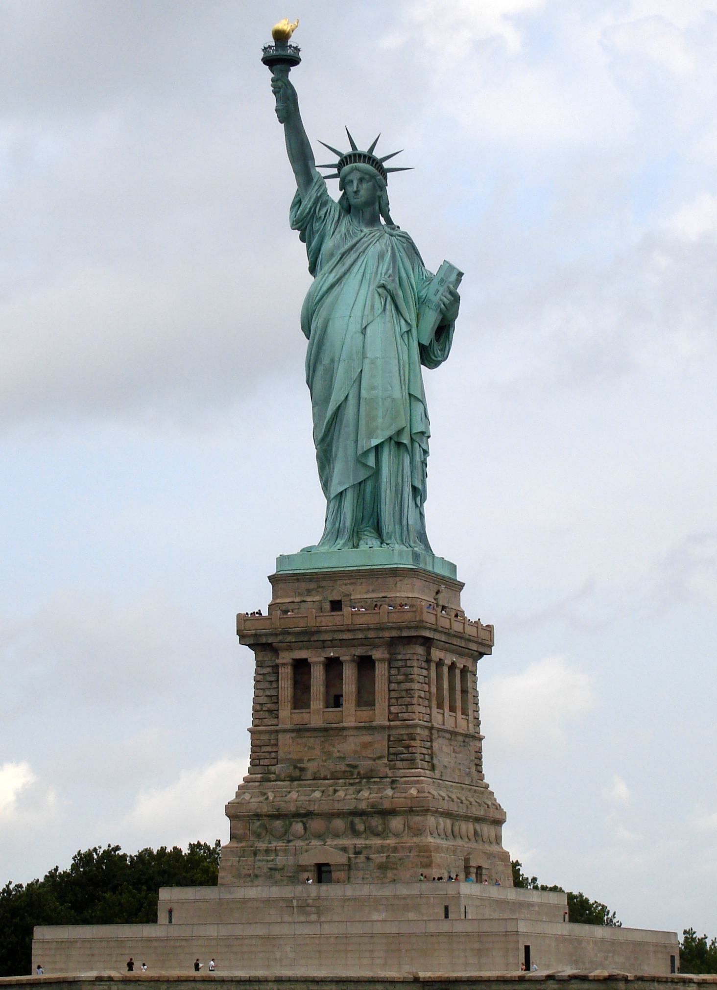
Estados Unidos de América: Estatua de la Libertad en New York


Full resolution(1,464 × 2,022 pixels, file size: 1.71 MB, MIME type: image/jpeg); ZoomViewer: flash/no flash
"La libertad iluminando el mundo» (Liberty Enlightening the World), conocida como la Estatua de la Libertad (Statue of Liberty en inglés, Statue de la Liberté en francés), es uno de los monumentos más famosos de Nueva York, de los Estados Unidos y de todo el mundo. Se encuentra en la isla de la Libertad al sur de la isla de Manhattan, junto a la desembocadura del río Hudson y cerca de la isla Ellis. La Estatua de la Libertad fue un regalo de los franceses a los estadounidenses en 1886 para conmemorar el centenario de la Declaración de Independencia de los Estados Unidos y como un signo de amistad entre las dos naciones. Fue inaugurada el 28 de octubre de 1886 en presencia del presidente estadounidense de la época, Grover Cleveland. La estatua es obra del escultor francés Frédéric Auguste Bartholdi y la estructura interna fue diseñada por el ingeniero Gustave Eiffel.[2] El arquitecto francés Eugène Viollet-le-Duc se encargó de la elección de los cobres utilizados para la construcción de la estatua. El 15 de octubre de 1924, la estatua fue declarada como monumento nacional de los Estados Unidos y el 15 de octubre de 1965 se añadió la isla Ellis. Desde 1984 es considerada Patrimonio de la Humanidad por la Unesco.[2]
La Estatua de la Libertad, además de ser un monumento importante en la ciudad de Nueva York, se convirtió en un símbolo en Estados Unidos y representa, en un plano más general, la libertad y emancipación con respecto a la opresión. Desde su inauguración en 1886, la estatua fue la primera visión que tenían los inmigrantes europeos al llegar a Estados Unidos tras su travesía por el océano Atlántico. En términos arquitectónicos, la estatua recuerda al famoso Coloso de Rodas, una de las «siete maravillas del mundo». Fue nominada para las «nuevas maravillas del mundo», donde resultó finalista. El nombre asignado por la Unesco es «Monumento Nacional Estatua de la Libertad». Desde el 10 de junio de 1933 se encarga de su administración el Servicio de Parques Nacionales de los Estados Unidos.
Wikipedia.

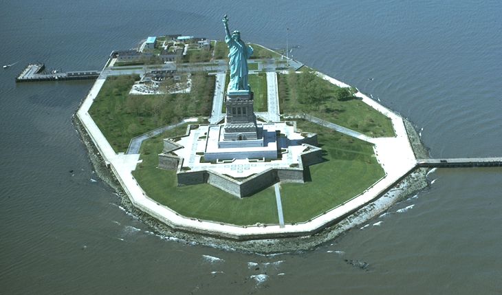
Liberty_Island.jpg(730 × 429 pixels, file size: 53 KB, MIME type: image/jpeg)
Vista aérea de la Estatua y de la isla de la Libertad. Wikipedia.
Estatua de Libertad cierra desde octubre 2011 y al menos un año por reformas
Mapa

Estatua de Libertad cierra desde octubre 2011 y al menos un año por reformas
Por Agencia EFE–10/08/2010
Nueva York, 10 ago (EFE).- La Estatua de la Libertad de Nueva York permanecerá cerrada a partir de octubre de 2011 para que se puedan efectuar distintas reformas que mejoren la seguridad de los visitantes del conocido monumento y que podrían alargarse al menos un año, según detallan hoy medios locales.
"El proceso para aprobar cambios en estructuras históricas como la Estatua de la Libertad lleva su tiempo. Cuando reabrimos el observatorio en 2009, éramos conscientes de que sería necesario realizar mejoras a partir del otoño de 2011", explicó en un comunicado Mindi Rambo, portavoz del Servicio Nacional de Parques.
La reformas que estudian los responsables de Lady Liberty -como se la conoce en Nueva York- costarán unos 26 millones de dólares e implicarán la construcción de dos nuevas salidas del monumento, así como un cortafuegos entre la estatua y el pedestal en el que descansa.
Además, se acometerán varias reformas en las escaleras con las que cuenta la estatua, ya que las actuales no se adecúan a los códigos de seguridad, que deben permitir que la evacuación del edificio en caso de incendio pueda llevarse a cabo en dos horas.
"Todos esos cambios, junto a otras mejoras en los planes de emergencia que rigen a la estatua permitirán que se aumente el número de visitantes que suben al observatorio y se mejore su seguridad", añadieron los responsables del monumento, uno de los puntos de visita obligada en la Gran Manzana.
Mientras duren las obras la estatua permanecerá cerrada, pero los visitantes que quieran acercarse a ella podrán seguir haciéndolo, ya que estará permitido el acceso a la isla en la que se alza.
El monumento fue desalojado el 21 de julio tras activarse por error un detector de humo en uno de sus ascensores, que hizo pensar a sus responsables que se había producido un incendio en la estructura de Lady Liberty, por lo que evacuaron a los cientos de turistas que la visitaban ese día.
El acceso a la Estatua de la Libertad se cerró después de los ataques a las Torres Gemelas el 11 de septiembre de 2001, aunque en agosto del 2004 se reabrió al público la base del monumento bajo estrictos controles.
Desde el año pasado, el observatorio situado en la corona de la Estatua de la Libertad, al que se accede por una estrecha escalera en espiral de 168 peldaños, se reabrió al público y desde entonces ha recibido la visita de unas 85.000 personas.
El monumento, obra en cobre del escultor Frédéric Auguste Bartholdi, se forjó en Francia y fue transportada en barco a Nueva York, donde se instaló en 1886 como regalo del pueblo francés a Estados Unidos para conmemorar el centenario de la independencia de este país.
EFE
Guillermo Gonzalo Sánchez Achutegui
Inscríbete en el Foro del blog y participa : A Vuelo De Un Quinde - El Foro!

sábado, 8 de junio de 2013

nsf.gov - Discovery - On World Environment Day and Every Day, the Stress of Being Ginseng

Common medicinal plant of deciduous forests under siege.-

 Painting of the herb American ginseng
The unassuming herb American ginseng, hidden in cool woodlands.
Credit: Susan Bull Riley
Download the high-resolution JPG version of the image. (2.1 MB)
 Scientist James McGraw next to American ginseng in the wild
Scientist James McGraw on the level with the subject of his research: American ginseng.
Credit: James McGraw, West Virginia University
Download the high-resolution JPG version of the image. (510 KB)
 A forest of the northeastern U.S. with american ginseng plants
Typical American ginseng habitat: the deciduous forests of the northeastern U.S.
Credit: James McGraw, West Virginia University
Download the high-resolution JPG version of the image. (2.1 MB) 
Close-up photo of American ginseng plant with red berries
Panax quinquefolius (American ginseng) with berries; Panax translates to "all healing."
Credit: USFWS
Download the high-resolution JPG version of the image. (154 KB)

 captured image of a wood thrush eating a ginseng berry
Wood thrush eating a ginseng berry; the birds are important ginseng seed-dispersers.
Credit: James McGraw, West Virginia University
Download the high-resolution JPG version of the image. (698 KB) 
 Researcher Kerry Wixted next to invasive plants in an American ginseng habitat
Researcher Kerry Wixted studying the effects of invasive plants on American ginseng.
Credit: James McGraw, West Virginia University
Download the high-resolution JPG version of the image. (1.8 MB)

This article is the sixth in a series on NSF's Long Term Research in Environmental Biology (LTREB) awards. Visit parts one, two, three, four, and five.
We entered a vale at 5 o'clock, then crossed a run and rode along a rich level for several miles, and under the delightful protection of very tall trees that brought us to a creek...where we lodged surrounded by ginseng.
--John Bartram, 1751, Travels from Pensilvania to Onandaga, Oswego and Lake Ontario in Canada
Being surrounded by ginseng--a low-growing green-leafed herb of North American forests--may have been common in 1751, but today? Ginseng is under siege.
Biologist James McGraw of West Virginia University should know. Today on World Environment Day, and indeed every day, McGraw says that we can learn much about the environment around us from one small plant.
Funded by a National Science Foundation (NSF) Long Term Research in Environmental Biology (LTREB) grant, McGraw and colleagues peer into the lives of more than 4,000 individual ginseng plants each year to see how they're faring.
"These understory plants are subject to all manner of [environmental] stresses," says McGraw. "After a while, you begin to wonder why there are any left."

Facing a panoply of threats
First, he says, there's harvesting for medicinal uses, "which is widespread and often illegally or at least unethically done. Then we have our four-footed friends--white-tailed deer--which eat a significant number of plants every year."
The plants' next challenge is the growth of invasive species such as multiflora rose and garlic mustard, which compete with ginseng.
The effects of global warming, including summers with heat waves and droughts, add to the burden for these plants of cooler climes. "Ginseng is also affected by ice storms, late frosts and hurricane flooding," says McGraw.
Then these Indiana Joneses of the plant world must survive what McGraw refers to as "natural pests:" insects defoliators and fungal pathogens.
Last--but definitely not least--is us.
"We're just beginning to understand what humans are doing to the forests where ginseng thrives: timbering, suppressing natural fires, mining, clearing land for housing developments, the list goes on and on," says McGraw.
The persistence of a slow-growing and valuable medicinal plant "despite all this," he says, "is a testament to the resilience of nature--and to the stewardship of those land-owners who care about protecting biodiversity in their forests."

Species in an extinction vortex
Tigers, elephants and ginseng all share a common feature, says Saran Twombly, director of NSF's LTREB program.
"These dwindling populations face increasing threats that trap them in an extinction vortex," Twombly says.
"McGraw's research relies on long-term data to identify the factors threatening populations of this important forest plant. The results show the knife-edge that separates healthy and unhealthy populations."
The NSF LTREB award "has been critical to our understanding of the 'big picture' of ginseng conservation," says McGraw.
He and colleagues work on one species of ginseng, Panax quinquefolius L., American ginseng. This member of the ginseng family, whose genus name Panax means "all heal" in Greek, hides deep in eastern deciduous woodlands.
The plant was historically found in rich, cool hardwood forests--from southern Quebec and Ontario south to northern Georgia, and west as far as Minnesota, eastern Oklahoma and northern Louisiana.
"Ginseng populations vary from frequent to uncommon to rare across the landscape," says McGraw, "but they're almost always small, usually fewer than 300 plants."

Medicinal plant for the ages
The species has long been valued for its medicinal qualities, especially by Asian cultures. They've integrated American ginseng into traditional medicinal practices as a complement to native Asian ginseng species.
In Asia, ginseng is considered an adaptogen--it enhances overall energy levels.
"In western medicine, ginseng has exhibited anti-cancer properties in cell cultures," says McGraw. "It's also shown beneficial effects on blood sugar and obesity, as well as on enhancing the immune system for prevention of colds and flu."
After ginseng was discovered in North America, the market quickly became profitable enough to fuel intense wild harvesting, eventually reaching an industrial scale.
"Ginseng shares a part of early American history," says McGraw. "Its roots--the most sought-after parts--were first exported to Asia from the United States in the early 1700s."
In one typical year (1841), more than 290,000 kilograms of dry ginseng roots were shipped from North America to the Asian continent.
"Although average root size was larger in the 1800s than it is today," says McGraw, "even a conservative estimate suggests that this represents at least 64 million roots."

Ginseng at the forefront
Harvest of the plant has continued apace, he says, particularly in the Appalachian region, where the sale of ginseng still supplements household incomes.
Ecologists began studying ginseng because of its value as a wild-harvested species, and its decrease in abundance after decades of harvesting.
Now, however, ginseng has become an important model species--a sensitive indicator of the effects of global and regional environmental change on deciduous forests.
"The prominence of American ginseng has led to its use as a 'phytometer' [a gauge] to better understand how change is affecting lesser-known plant species in eastern North America," says McGraw.
The data in his project come from 30 ginseng populations in seven states. "Our study populations are in habitats from suburban woodlots to rich, old-growth forests," McGraw says.
In a paper published this year in the Annals of The New York Academy of Sciences, McGraw and co-authors state that the Asian market has made ginseng North America's most important harvested wild medicinal plant over the past two centuries.
That status prompted a listing on CITES (Convention on International Trade in Endangered Species of Wild Fauna and Flora) Appendix II. All species on Appendix II are susceptible to extinction in the absence of trade controls.
Most states with ginseng populations are converging on a uniform start date for harvesting--Sept. 1. "That allows time after harvest for planting ripe seeds that will lead to recovery of the plants," McGraw says.
Since forests are, for the most part, open to everyone, ginseng will continue to be harvested as long as there is immediate profit to be made, scientists believe.
Successful sustainability in such open access habitats, they say, depends on management of the resource by those who actively harvest it.

Sustainability and ginseng
McGraw and colleagues' research shows that ginseng harvesters willing to employ a stewardship strategy gain the most benefit by harvesting when seeds are ripe, usually in autumn months, then planting the seeds to ensure high germination rates.
September is a summertime away. But in northeastern forests, ginseng leaves have already unfurled.
"Now they face a gamut of environmental challenges," says McGraw. "They're rooted in place, left with whatever nature--or more likely humans--dish out. If we want ginseng to be part of the future landscape, we had best tread very carefully."
"Ginseng is not everywhere common," wrote Swedish naturalist Peter Kalm in 1749. "Sometimes you may search the woods for several miles without finding a single plant. Round Montreal they formerly grew in abundance, but there is not a single plant to be found, so they have been rooted out."
By three centuries later, northeastern forests may be empty--at least of an unassuming and "all healing" herb named ginseng.
--  Cheryl Dybas, NSF (703) 292-7734    cdybas@nsf.gov
Related Websites
NSF LTREB Project: Wild Ginseng Conservation:  
http://www.wildginsengconservation.com
NSF Science, Engineering and Education for Sustainability Programs:
 http://www.nsf.gov/sees
NSF Publication: Discoveries in Long-Term Environmental Research:

The  National Science Foundation (NSF)
Guillermo Gonzalo Sánchez Achutegui
ayabaca@gmail.com
ayabaca@hotmail.com
ayabaca@yahoo.com
Inscríbete en el Foro del blog y participa : A Vuelo De Un Quinde - El Foro!

martes, 4 de diciembre de 2012

NASA - Climate Models Project Increase in U.S. Wildfire Risk

Climate Models Project Increase in U.S. Wildfire Risk
Scientists using NASA satellite data and climate models have projected drier conditions likely will cause increased fire activity across the United States in coming decades. Other findings about U.S. wildfires, including their amount of carbon emissions and how the length and strength of fire seasons are expected to change under future climate conditions, were also presented Tuesday at the annual meeting of the American Geophysical Union in San Francisco.
 http://www.nasa.gov/images/content/710937main_climate-fire-lg.jpg
The Whitewater-Baldy Complex wildfire in Gila National Forest, New Mexico, as it burned on June 6th, 2012. Scientists calculate that high fire years like 2012 are likely occur two to four times per decade by mid-century, instead of once per decade under current climate conditions. Credit: Kari Greer/USFS Gila National Forest
› Larger image

Doug Morton of NASA's Goddard Space Flight Center in Greenbelt, Md., presented the new analysis of future U.S. fire activity. The analysis was based on current fire trends and predicted greenhouse gas emissions.

"Climate models project an increase in fire risk across the U.S. by 2050, based on a trend toward drier conditions that favor fire activity and an increase in the frequency of extreme events," Morton said.

The analysis by Morton and colleagues used climate projections, prepared for the Fifth Assessment Report of the United Nations Intergovernmental Panel on Climate Change, to examine how dryness, and therefore fire activity, is expected to change.

› High res download of video
The U.S. fire season in 2012 was by some measures a record-breaking season. NASA scientist Doug Morton discusses the links between climate and wildfires and the likelihood of seeing more extreme fire events in the future. Credit: NASA

The researchers calculated results for low and high greenhouse gas emissions scenarios. In both cases, results suggest more fire seasons that are longer and stronger across all regions of the U.S. in the next 30-50 years. Specifically, high fire years like 2012 would likely occur two to four times per decade by mid-century, instead of once per decade under current climate conditions.
A Landsat 7 image of the 60,000 acres burned by the High Park wildfire just west of Fort Collins, CO as of June 18, 2012.› Larger image
A Landsat 7 image of the 60,000 acres burned by the High Park wildfire just west of Fort Collins, CO as of June 18, 2012. The fire, which started on June 9 by a lightning strike, destroyed 189 homes as of June 19. In the June 18 image, clouds hover just north of the burned area, with smoke from the fire visible as blue. Credit: USGS/NASA
A visualization of cumulative fires from Jan. 1 through Oct. 31, 2012, detected by the MODIS instrument on board the Terra and Aqua satellites.  Bright yellow shows areas that are more intense and have a larger area that is actively burning, flaming and or smoldering.› Larger image
A visualization of cumulative fires from Jan. 1 through Oct. 31, 2012, detected by the MODIS instrument on board the Terra and Aqua satellites. Bright yellow shows areas that are more intense and have a larger area that is actively burning, flaming and/or smoldering. Credit: NASA Through August of this year, the U.S. burned area topped 2.5 million hectares (6.17 million acres), according to a fire emissions database that incorporates burned area estimates produced from observations by the Moderate Resolution Imaging Spectroradiometer instruments on NASA's Aqua and Terra satellites. That is short of the record 3.2 million hectares (7.90 million acres) burned in 2011, but exceeds the area burned during 12 of the 15 years since record keeping began in 1997. This and other satellite records, along with more refined climate and emissions models, are allowing scientists to tease out new information about fire trends.

"Fire is an inherently global phenomenon, and the only practical way to track large-scale patterns and changes in fire activity is with satellites," says Louis Giglio of the University of Maryland at College Park and Goddard.

As the U.S. land area burned by fire each year has increased significantly in the past 25 years, so too have the emissions. Carbon dioxide emissions from wildfires in the western U.S. have more than doubled since the 1980s, according to Chris Williams of Clark University in Worcester, Mass.

The satellite-based view allowed Williams and his colleagues to quantify how much carbon has been released from fires in the U.S. West. The team used data on fire extent and severity derived from Landsat satellites to calculate how much biomass is burned and killed, and how quickly the associated carbon was released to the atmosphere. The team found carbon emissions from fires have grown from an average of 8 teragrams (8.8 million tons) per year from 1984 to 1995 to an average of 20 teragrams (22 million tons) per year from 1996 to 2008, increasing 2.4 times in the latter period.

"With the climate change forecast for the region, this trend likely will continue as the western U.S. gets warmer and drier on average," Williams said. "If this comes to pass, we can anticipate increased fire severity and an even greater area burned annually, causing a further rise in the release of carbon dioxide."

Researchers expect a drier and more wildfire-prone U.S. in future decades. Previous research confirmed the connection between the measure of an environment's potential evaporation, or dryness, and fire activity.

From a fire and emissions management perspective, wildfires are not the entire U.S. fire story, according to research by Hsiao-Wen Lin of the University of California at Irvine. Satellite data show agricultural and prescribed fires are a significant factor and account for 70 percent of the total number of active fires in the continental U.S. Agricultural fires have increased 30 percent in the last decade.

In contrast with wildfires, agricultural and prescribed fires are less affected by climate, especially drought, during the fire season.

"That means there is greater potential to manage fire emissions, even in a future, drier climate with more wildfires. We need to use cost-benefit analysis to assess whether reductions in agricultural fire emissions -- which would benefit public health -- would significantly impact crop yields or other ecosystem services," Lin said.

Related Links:

› Powerpoint slides (in PDF format) from the 2012 AGU Conference briefing
› Video of active fires across the U.S. in 2012
› Link to video in Powerpoint presentation
› Link to Flickr gallery in Powerpoint presentation


Kathryn Hansen
NASA's Goddard Space Flight Center, Greenbelt, Md.
GuillermoGonzalo Sánchez Achutegui
ayabaca@gmail.com
ayabaca@hotmail.com
ayabaca@yahoo.com
 Inscríbete en el Foro del blog y participa : A Vuelo De Un Quinde - El Foro!

martes, 11 de septiembre de 2012

USA: NASA - New York City on September 11, 2001

From top to bottom: the World Trade Center burning; a section of the Pentagon collapses; Flight 175 crashes into 2 WTC; a fireman requests help at Ground Zero; an engine from Flight 93 is recovered; Flight 77 crashes into the Pentagon.
Location New York City; Arlington County, Virginia; and near Shanksville, Pennsylvania.
Date Tuesday, September 11, 2001
8:46 a.m. – 10:28 a.m. (UTC-04:00)
Attack type Aircraft hijacking, mass murder, suicide attack, terrorism
Deaths 2,996
Injured More than 6,000
Perpetrators al-Qaeda[1]
(See also responsibility and hijackers). Wikipedia

The September 11 attacks (also referred to as September 11, September 11th, or 9/11)[nb 1] were a series of four coordinated suicide attacks upon the United States in New York City and the Washington, D.C. areas on September 11, 2001. On that Tuesday morning, 19 terrorists from the Islamist militant group al-Qaeda hijacked four passenger jets. The hijackers intentionally flew two of those planes, American Airlines Flight 11 and United Airlines Flight 175, into the North and South towers of the World Trade Center complex in New York City; both towers collapsed within two hours. The hijackers also intentionally crashed American Airlines Flight 77 into the Pentagon in Arlington, Virginia, and intended to pilot the fourth hijacked jet, United Airlines Flight 93, into the United States Capitol Building[2] in Washington, D.C.; however, the plane crashed into a field near Shanksville, Pennsylvania, after its passengers attempted to take control of the jet from the hijackers. Nearly 3,000 people died in the attacks, including all 227 civilians and 19 hijackers aboard the four planes.
Suspicion quickly fell on al-Qaeda, and in 2004, the group's leader, Osama bin Laden, who had initially denied involvement, claimed responsibility for the attacks.[1] Al-Qaeda and bin Laden cited U.S. support of Israel, the presence of U.S. troops in Saudi Arabia, and sanctions against Iraq as motives for the attacks. The United States responded to the attacks by launching the War on Terror and invading Afghanistan to depose the Taliban, which had harbored al-Qaeda. Many countries strengthened their anti-terrorism legislation and expanded law enforcement powers. In May 2011, after years at large, bin Laden was located and killed.
The destruction of the Twin Towers caused serious damage to the economy of Lower Manhattan and had a significant impact on global markets. Cleanup of the World Trade Center site was completed in May 2002, and the Pentagon was repaired within a year. Numerous memorials were constructed, including the National September 11 Memorial & Museum in New York, the Pentagon Memorial, and the Flight 93 National Memorial in Pennsylvania. After a lengthy delay, the 1,776-foot-tall (541 m) One World Trade Center is expected to be completed at Ground Zero in New York by 2013.[3]Wikipedia
The 11th anniversary of the Sept. 11, 2001, terrorist attacks,  President Obama and first lady Michelle Obama.
Across the country, Americans marked the 11th anniversary of the Sept. 11, 2001, terrorist attacks, tolling church bells, pausing in silence to reflect and mourning the loss of the nearly 3,000 people who died.
On the White House South Lawn, President Obama and first lady Michelle Obama bowed their heads at 8:46 a.m., the moment the first plane struck the North Tower of the World Trade Center. They later laid a wreath at the Pentagon, where the third plane struck. A flag was draped over the building to mark the day.
Video
President Barack Obama and First Lady Michelle Obama had a moment of silence at the White House Tuesday morning to pay tribute to the 11th anniversity of September 11th, 2001. The President and Secretary of Defense Leon Panetta also spoke at a memorial service at the Pentagon.
More from PostPolitics

Nine deep thoughts on our new poll

Nine deep thoughts on our new poll
THE FIX | We dig into the new Washington Post-ABC News poll data so you don't have to.

Understanding the defense-cut battle

Understanding the defense-cut battle
FACT CHECKER | We dissect and explain the blizzard of Washington gobbledygook over sequestration.

The ‘captain of the ship’ challenge

The ‘captain of the ship’ challenge
THE FIX | Romney must convince voters that he is uniquely suited to steer the ship during these economic times.
“Eleven times we have marked another September 11th come and gone. Eleven times, we have paused in remembrance, in reflection, in unity and in purpose,” Obama said to families and military brass who gathered at the Pentagon, where 184 were killed. “This is never an easy day.”
At Arlington National Cemetery, the Obamas visited the graves in Section 60, one of the sections where those killed in Afghanistan and Iraq are buried under white marble markers.
They placed a “challenge coin” on a collective memorial to the victims of an Oct. 29, 2009, helicopter crash in Afghanistan.
At a ceremony in Manhattan, where One World Trade Center is under construction, the families of victims read the names of loved ones killed in the attacks, and traders on the floor of the New York Stock Exchange stood silent.
In Shanksville, Pa., where United Airlines Flight 93 crashed in an open field after being hijacked by four terrorists, Vice President Biden spoke of the sacred, hallowed ground, weaving in his own experience of loss to comfort the families of the 40 passengers and crew members who died there.
“For no matter how many anniversaries you experience, for at least an instant, the terror of that moment returns; the lingering echo of that phone call; that sense of total disbelief that envelops you, where you feel like you’re being sucked into a black hole in the middle of your chest,” said Biden, whose first wife and baby daughter were killed in a car accident 40 years ago. “My hope for you all is that as every year passes, the depth of your pain recedes and you find comfort, as I have, genuine comfort in recalling his smile, her laugh, their touch.”
Thousands of miles away, in Kabul, troops prayed and reflected on the event that triggered America’s longest war.
In Reno, Nev., where he delivered a speech on foreign policy, Republican presidential hopeful Mitt Romney shared his own memories from Sept. 11, 2001, when he was in Washington as the head of the Winter Olympic Games, meeting with members of Congress about security preparations for the Salt Lake City Games.
He said he watched the second plane hit the World Trade Center on a small television on his desk. Later, he recalled, he left Washington and passed by the Pentagon just after he crossed the Potomac River.
“Cars had stopped where they were and people had gotten out, watching in horror,” Romney said. “I could smell burning fuel and concrete and steel. It was the smell of war, something I never imagined I would smell in America.”
 The Washington Post.

Download Image

› Full Size 
Guillermo Gonzalo Sánchez Achutegui
ayabaca@gmail.com
ayabaca@hotmail.com
ayabaca@yahoo.com
 Inscríbete en el Foro del blog y participa : A Vuelo De Un Quinde - El Foro!

miércoles, 22 de agosto de 2012

Library of Congress: Herblock & Photographers Observe the Environment


 This service is provided by the Library of Congress at www.LOC.gov.
 ["Welwyn," Harold Irving Pratt house, 100 Crescent Beach Road, Glen Cove, New York. (LOC)
Johnston, Frances Benjamin,, 1864-1952,, photographer.
["Welwyn," Harold Irving Pratt house, 100 Crescent Beach Road, Glen Cove, New York. Rhododenron at terrace wall]
  
[George Warrington Curtis house, Southampton, New York. (LOC)
Johnston, Frances Benjamin,, 1864-1952,, photographer. [George Warrington Curtis...
Uploaded on Aug 17, 2012
  [Dr. Charles William Richardson house, Chevy Chase, Washington, D.C. (LOC)
Johnston, Frances Benjamin,, 1864-1952,, photographer. [Dr. Charles William...


News from the Library of Congress

“Down to Earth: Herblock and Photographers Observe the Environment” Opens at Library of Congress on Sept. 22

Throughout his 72-year career, Herblock, the award-winning cartoonist at the Washington Post, revealed a concern and passion for the environment. His cartoons, along with photographs on environmental issues by 12 American photographers, will be showcased in a new exhibition at the Library of Congress.
"Down to Earth: Herblock and Photographers Observe the Environment" opens on Saturday, Sept. 22 in the Graphic Arts Galleries on the ground level of the Thomas Jefferson Building, 10 First St. S.E., Washington, D.C. Free and open to the public from 8:30 a.m. to 4:30 p.m., Monday through Saturday, the exhibition closes on Saturday, March 23, 2013.
The exhibition will offer new perspectives with which to observe the planet. The cartoons and photographs on display are compelling compositions, because their creators intended to provoke reaction and inspire change.
The inspiration for "Down to Earth" comes from Herbert L. Block (1909-2001), commonly called Herblock, and his long-standing support for protecting the environment. A four-time Pulitzer Prize winner, Herblock was the chief editorial cartoonist at the Washington Post, where he worked for more than 55 years.
The exhibition features 15 Herblock cartoons and 17 photographs. Although the visual techniques used in photography and cartooning differ, both types of media can address such themes as the spread of toxins, water pollution, the negative effects of oil drilling, global warming, deforestation, exploitation of wetlands and overconsumption.
Sam Kittner’s photographs vividly document the outrage of demonstrators in Louisiana over toxic-waste dumping. Other images are more subtle, such as Olaf Otto Becker’s beautiful image of a blue river in Greenland that shows the effects of global warming and acid rain.
Herblock’s cartoons rely on humor, irony and sarcasm. One of the drawings on display, from 2001, shows two businessmen smoking cigars and looking at oil derricks on the Alaskan landscape. It is titled "We Could Compromise and Paint Them Green." Another drawing, created in 1998, shows a beleaguered man, seen through the heat waves of a blazing sun. He is carrying a coat on one arm and is holding up a newspaper with the headline "Environmental Groups Warn of Global Warming." It is titled "All Right, All Right – I Believe It."
An online version of "Down to Earth" will be available on Saturday, Sept. 22, at myloc.gov/Exhibitions/herblock-down-to-earth/.
"Down to Earth" is located in one of the three exhibition spaces of the Graphic Arts Galleries. The other spaces are the Swann Gallery and the Herblock Gallery. Currently in the Herblock Gallery is "Herblock Looks at 1962: Fifty Years Ago Today in Editorial Cartoons," which will rotate in 10 new cartoons from 1962 on Saturday, Sept. 22.
Three gallery talks about "Down to Earth" are scheduled in October. At noon on Wednesday, Oct. 3, and at noon on Wednesday, Oct. 17, curators Sara Duke and Carol Johnson will talk about the works featured in the exhibition. At noon on Thursday, Oct. 11, photographer Robert Coppola will talk about his work.
Most of the photographs displayed in "Down to Earth" are part of the Kent and Marcia Minichiello Collection at the Library of Congress, which contains 350 contemporary works by more than 20 American photographers. The collection presents ongoing environmental issues through the lens of some of the most renowned American photographers working today, such as Terry Evans, Frank Golhke, Sam Kittner, John Pfahl and Victor Landweber. Kent and Marcia Minichiello, Washingtonians committed to the environment, collected 27 in-depth photographic projects by these photographers and others. The Minichiellos donated the collection to the Library in 2001.
The Herb Block Foundation donated a collection of more than 14,000 original cartoon drawings and 50,000 rough sketches, as well as manuscripts, to the Library of Congress in 2002, and has generously continued to provide funds to support ongoing programming.
The Library has been collecting original cartoon art for more than 140 years. It is a major center for cartoon research with holdings of more than 100,000 original cartoon drawings and prints. These works, housed in the Prints and Photographs Division, span five centuries and range from 17th-century Dutch political prints to 21st-century contemporary comic strips.
The Library of Congress Prints and Photographs Division includes approximately 14.4 million photographs, drawings and prints from the 15th century to the present day. International in scope, these visual collections represent a uniquely rich array of human experience, knowledge, creativity and achievement, touching on almost every realm of endeavor: science, art, invention, government and political struggle, and the recording of history. For more information, visit www.loc.gov/rr/print/.
For sample images from "Down to Earth," contact Donna Urschel at (202) 707-1639.
# # #
PR 12-155
08/20/12
ISSN 0731-3527
Guillermo Gonzalo Sánchez Achutegui
ayabaca@gmail.com
ayabaca@hotmail.com
ayabaca@yahoo.com
 Inscríbete en el Foro del blog y participa : A Vuelo De Un Quinde - El Foro!

jueves, 5 de julio de 2012

USA: Independence Day Solar Fireworks


Download Image

› Full Size

Independence Day Solar Fireworks

This image, captured by the Solar Dynamics Observatory, shows the M5.3 class solar flare that peaked on July 4, 2012, at 5:55 AM EDT. The flare is shown in the 131 Angstrom wavelength, a wavelength that is particularly good for capturing the radiation emitted from flares. The wavelength is typically colorized in teal as shown here.

Image Credit: NASA/SDO/AIA/Helioviewer
NASA
Guillermo Gonzalo Sánchez Achutegui
 ayabaca@gmail.com
 ayabaca@hotmail.com
ayabaca@yahoo.com 
 Inscríbete en el Foro del blog y participa : A Vuelo De Un Quinde - El Foro!

martes, 1 de mayo de 2012

Science: Scientists Find Night-Warming Effect Over Large Wind Farms in Texas

Hi My Friends: A VUELO DE UN QUINDE EL BLOG., Large wind farms in certain areas in the United States appear to affect local land surface temperatures, according to a paper published today in the journal Nature Climate Change.

Night-time land surface temperature differences near wind farms between 2010 and 2013.

Credit: Liming Zhou et al., Nature Climate Change.
Wind farms are numerous in parts of Texas; scientists report new results on their effects.

Credit: U.S. Department of Energy
Locations of clusters of Texas wind farms, as of the year 2010.

Credit: State of Texas

Wind farms dot the horizon in Lubbock County and other Texas areas.

Credit: Lubbock County, Texas

A new kind of Texas ranch--a wind ranch.

Credit: Wikimedia Commons

A Texas wind farm shares space with cacti and other desert-dwellers.

Credit: Wikimedia Commons

Large wind farms in certain areas in the United States appear to affect local land surface temperatures, according to a paper published today in the journal Nature Climate Change.
The study, led by Liming Zhou, an atmospheric scientist at the State University of New York- (SUNY) Albany, provides insights about the possible effects of wind farms.
The results could be important for developing efficient adaptation and management strategies to ensure long-term sustainability of wind power.
"This study indicates that land surface temperatures have warmed in the vicinity of large wind farms in west-central Texas, especially at night," says Anjuli Bamzai, program director in the National Science Foundation's (NSF) Division of Atmospheric and Geospace Sciences, which funded the research.
"The observations and analyses are for a relatively short period, but raise important issues that deserve attention as we move toward an era of rapid growth in wind farms in our quest for alternate energy sources."
Considerable research has linked the carbon dioxide produced by burning fossil fuels with rising global temperatures.
Consequently, many nations are moving toward cleaner sources of renewable energy such as wind turbines. Generating wind power creates no emissions, uses no water and is likely "green."
"We need to better understand the system with observations, and better describe and model the complex processes involved, to predict how wind farms may affect future weather and climate," said Zhou.
There have been a growing number of studies of wind farm effects on weather and climate, primarily using numerical models due to the lack of observations over wind farms.
As numerical models are computationally intensive and have uncertainties in simulating regional and local weather and climate, said Zhou, remote sensing is likely the most efficient and effective way to study wind farm effects over larger spatial and longer temporal scales.
To understand the potential impact of wind farms on local weather and climate, Zhou's team analyzed satellite-derived land surface temperatures from regions around large wind farms in Texas for the period 2003-2011.
The researchers found a night-time warming effect over wind farms of up to 0.72 degrees Celsius per decade over the nine-year-period in which data were collected.
Because the spatial pattern of warming mirrors the geographic distribution of wind turbines, the scientists attribute the warming primarily to wind farms.
The year-to-year land surface temperature over wind farms shows a persistent upward trend from 2003 to 2011, consistent with the increasing number of operational wind turbines with time.
"This warming effect is most likely caused by the turbulence in turbine wakes acting like fans to pull down warmer near-surface air from higher altitudes at night," said Somnath Baidya Roy of the University of Illinois at Urbana-Champaign, a co-author of the paper.
While the warming effect reported is local and small compared to the strong background year-to-year land surface temperature variation, the authors believe that this work draws attention to an important scientific issue that requires further investigation.
"The estimated warming trends only apply to the study region and to the study period, and thus should not be interpolated into other regions, globally or over longer periods," Zhou said. "For a given wind farm, once there are no new wind turbines added, the warming effect may reach a stable level."
The study represents a first step in exploring the potential of using satellite data to quantify the possible effects of the development of big wind farms on weather and climate, said Chris Thorncroft of SUNY-Albany, a co-author of the paper.
"We're expanding this approach to other wind farms," said Thorncroft, "and building models to understand the physical processes and mechanisms driving the interactions of wind turbines and the atmosphere boundary layer near the surface."
Other authors of the paper include Lance Bosart at SUNY-Albany, Yuhong Tian of NOAA, and Yuanlong Hu at Terra-Gen Power LLC in San Diego, Calif.
-NSF-
Guillermo Gonzalo Sánchez Achutegui
ayabaca@gmail.com
ayabaca@hotmail.com
ayabaca@yahoo.com
Inscríbete en el Foro del blog y participa : A Vuelo De Un Quinde - El Foro!

Mi lista de blogs