Mostrando entradas con la etiqueta Wildfires. Mostrar todas las entradas

domingo, 23 de julio de 2017

The National Science Foundation (NSF) :Researchers discover how wildfires create their own weather .- Los investigadores descubren cómo los incendios forestales crean su propio clima

https://www.nsf.gov/discoveries/disc_summ.jsp?cntn_id=242554&WT.mc_id=USNSF_1


In a season of fast-spreading western U.S. and Canada fires, information is timely
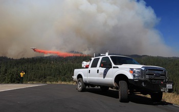
Doppler LiDAR is measuring winds near the plume of the King Fire in California in September, 2014.

Doppler LiDAR is measuring winds near the plume of the King Fire in California in September, 2014.
Credit and Larger Version

July 20, 2017
Find related stories on NSF's geosciences risk and resilience interest area.
Scientists working close to the line of wildfires are obtaining a new understanding of the fires' smoke plumes. The results are providing real-time information, such as vertical wind profiles, to firefighters battling blazes.
Through this National Science Foundation (NSF)-funded research, Craig Clements, a meteorologist at San José State University (SJSU), and researcher Neil Lareau, also of SJSU, have discovered that wildfires can create their own weather, leading to extreme fire behavior.
In a paper recently published in the Journal of Applied Meteorology and Climatology, the scientists report findings from inside wildfire plumes, information previously obtained only from computer simulations.
"This research offers rare observations of the behavior of wildfire smoke plumes," says Nick Anderson, program director in NSF's Division of Atmospheric and Geospace Sciences, which supported the research. "Improved understanding of wildfire plumes is important for determining whether smoke will stay near the ground and affect air quality and visibility, or whether it will rise into the atmosphere and potentially affect clouds and the amount of sunlight reaching the ground."
The SJSU researchers mounted Doppler LiDAR (Light Detection and Ranging, a remote-sensing method that uses light in the form of a pulsed laser to measure distances) instruments onto a pickup truck, which they placed near wildfires. "Until now," says Clements, "it has been difficult to sample wildfires with such sophisticated instruments because of logistical and safety concerns."
The team overcame that by obtaining firefighter credentials, which allowed them access to active wildfires, and by using a nimble, truck-mounted system that could be rapidly deployed. "Our work is providing new information about fire-atmosphere interactions and how wildfires spread," says Clements.
In addition to conducting research at active wildfires in the western U.S., the scientists performed controlled field experiments, setting fires and monitoring their rapid spread through an array of atmospheric instrumentation.
These studies gave the researchers information on how wildfires create their own weather systems. Those weather systems, in turn, fuel extreme fire behavior.
In their journal paper, the scientists present observations from the El Portal Fire of July, 2014, in Yosemite National Park, California.
The results revealed vigorous, fire-generated updrafts, says Clements, and strongly turbulent eddies that formed along the fire plume's edges. The data also showed that fire-modified winds extended more than one mile from the fire itself.
The findings confirm longstanding, but previously unvalidated, predictions for how plumes rise from fires, and offer new insights into the processes that control how high and how far wildfire smoke will spread. a vuelo
In addition to the El Portal Fire, the team has studied 22 other large wildfires in the western U.S.
"We're seeing a large number of fires," says Clements. "Many are extreme in terms of intensity. Higher-intensity fires cause deeper plumes, which can help spread fires by lofting embers and causing spot fires.
"That situation is dangerous for both firefighters and communities that are in the paths of fires -- like those in British Columbia and California this summer. We need more sophisticated models to better predict fire behavior, especially in a changing climate."
-- Cheryl Dybas, NSF (703) 292-7734
  cdybas@nsf.gov
-- Robin McElhatton, SJSU (408) 924-1749
  robin.mcelhatton@sjsu.edu

Investigators Craig Clements
Related Institutions/Organizations San Jose State University Foundation
Total Grants $900,337
An experimental grass fire spreads under a meteorological tower.
Credit and Larger Version
The experimental grass fire spreads through instrumentation placed in a research plot.
Credit and Larger Version
Researchers watch the El Portal Fire plume's evolution in Yosemite National Park in July, 2014.
Credit and Larger Version
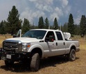
The plume of California's Bald Fire is sampled with mobile Doppler LiDAR in August, 2014.
Credit and Larger Version
Scientists use a mobile atmospheric profiling system near the Eiler Fire in Calif. in July, 2014.
Credit and Larger Version
National Science Foundation (NSF)
Guillermo Gonzalo Sánchez Achutegui
ayabaca@gmail.com
ayabaca@hotmail.com
ayabaca@yahoo.com
Inscríbete en el Foro del blog y participa : A Vuelo De Un Quinde - El Foro!

jueves, 25 de febrero de 2016

NSF: Increasing drought threatens almost all U.S. forests .- El aumento de la sequía amenaza a casi todos los bosques de Estados Unidos

Hola amigos: A VUELO DE UN QUINDE EL BLOG., hemos recibido información de la Fundación Nacional de Ciencias de Los Estados Unidos, nos dice: "Bosques en todo el país están sintiendo el calor de la creciente sequía y el cambio climático, según un nuevo estudio realizado por científicos de 14 instituciones de investigación.
"En las últimas dos décadas, las temperaturas más cálidas y precipitaciones variables han aumentado la severidad de las sequías forestales en gran parte del territorio continental de Estados Unidos", dijo James Clark, autor principal del estudio y científico ambiental en la Universidad de Duke.
Clark y sus colegas publicaron su trabajo en la revista Global Change Biology.
"Mientras que los efectos han sido más pronunciada en Occidente, nuestro análisis muestra virtualmente que todos los bosques de Estados Unidos están experimentando cambios y son vulnerables a futuras caídas", dijo Clark.
Es una tarea difícil predecir lo que estos bosques se verá como en 20 años, según los investigadores.
More information....
 
Forests nationwide feeling the heat

dried trees in a forest of pinons in the U.S. Southwest.
Drought has left little but skeleton trees in a forest of pinons in the U.S. Southwest.
Credit and Larger Version
February 22, 2016
Forests nationwide are feeling the heat from increasing drought and climate change, according to a new study by scientists from 14 research institutions.
"Over the last two decades, warming temperatures and variable precipitation have increased the severity of forest droughts across much of the continental United States," said James Clark, lead author of the study and an environmental scientist at Duke University.
Clark and colleagues published their paper today in the journal Global Change Biology.
"While the effects have been most pronounced in the West, our analysis shows virtually that all U.S. forests are now experiencing change and are vulnerable to future declines," Clark said.
It's a tall order to predict what these forests will look like in 20 years, the researchers say.
 
Drought across the U.S. West
 
Drought-induced forest diebacks (the deaths of entire communities of trees known as stands), bark beetle infestations, and wildfires are already occurring on large scales across the West. Many models predict droughts are likely to become more severe, frequent and prolonged across much of the U.S.
Evidence is also mounting that climate is changing faster than tree populations can respond.
As conditions become drier and warmer, many tree populations, especially those in Eastern forests, may not be able to expand into new, more favorable habitats, fast enough to keep up.
"Most forest research is carried out at local study sites, where trees are individually catalogued and measured," said Henry Gholz, a program director in the Division of Environmental Biology at the National Science Foundation (NSF), which supported the research. "This approach risks 'missing the forest for the trees.'"
The new results show that changes in both western and eastern U.S. forests could happen quickly under drier conditions in the future, said Gholz.
"Prolonged drought affects wildfire risks, species distribution, forest biodiversity and productivity, and virtually all goods and services provided by forests," Clark said, "so there is a pressing need to know what is happening now, what might happen in the future, and how we can manage for these changes."
 
Forests and drought, from A to Z
 
The new paper addresses this need by providing a comprehensive overview of current and projected drought effects on forests nationwide, how they vary by region, and which management practices could help to partially mitigate adverse effects.
The paper also identifies critical gaps in our knowledge base that hinder scientists' ability to predict the pace and extent of future drought effects on forests.
"We currently have a pretty good handle on predicting the impacts of climate change and drought on individual trees," Clark said. "Ecologists have identified many of the important differences between species that explain how they respond differently to drought."
But, he said, uncertainty still exists about what might happen at the species-wide or stand-wide levels, particularly in Eastern forests. "These are the scales where we really need reliable predictions so forest managers can take steps now to help reduce large-scale adverse future effects." 
Without a stronger basis for understanding how the complex interactions among trees, species and environmental conditions work at broader scales, even the most sophisticated current models can provide only limited guidance, Clark said. "That's where we need to focus our efforts now."
Major co-authors of the paper are Louis Iverson and Christopher W. Woodall of the U.S. Forest Service, as well as scientists with the U.S. Geological Survey, the University of Vermont, the University of California (UC), Santa Barbara, Sarah Lawrence College, the University of Michigan, the University of Arizona, Ohio State University, Harvard Forest, UC Davis, Northern Arizona University and the Swiss Federal Research Institute.
-NSF-

Media Contacts Cheryl Dybas, NSF, (703) 292-7734, cdybas@nsf.gov
Tim Lucas, Duke University, (919) 613-8084, tdlucas@duke.edu

Related WebsitesNSF News: Cause of California drought linked to climate change: https://www.nsf.gov/news/news_summ.jsp?cntn_id=132709
NSF News: Drought, heat likely to affect U.S. West's power grid: http://www.nsf.gov/news/news_summ.jsp?cntn_id=135021
NSF Discovery: Earth Week: Bark beetles change Rocky Mountain stream flows, affect water quality:
http://nsf.gov/discoveries/disc_summ.jsp?cntn_id=130951
NSF Discovery: Ghosts of Forests Past: Bark Beetles Kill Lodgepole Pines, Affecting Entire Watersheds:
 http://www.nsf.gov/discoveries/disc_summ.jsp?cntn_id=128398
NSF Discovery: Born during a drought: Bad news for baboons: http://nsf.gov/discoveries/disc_summ.jsp?cntn_id=134000&org=NSF


The National Science Foundation (NSF) is an independent federal agency that supports fundamental research and education across all fields of science and engineering. In fiscal year (FY) 2016, its budget is $7.5 billion. NSF funds reach all 50 states through grants to nearly 2,000 colleges, universities and other institutions. Each year, NSF receives more than 48,000 competitive proposals for funding and makes about 12,000 new funding awards. NSF also awards about $626 million in professional and service contracts yearly.
 Get News Updates by Email 
Useful NSF Web Sites:
NSF Home Page:
 http://www.nsf.gov
NSF News:
http://www.nsf.gov/news/
For the News Media:
 http://www.nsf.gov/news/newsroom.jsp
Science and Engineering Statistics:
http://www.nsf.gov/statistics/
Awards Searches: http://www.nsf.gov/awardsearch/
Wild fires in a forest
Wildfires, with flames fanned by drought, are happening on large scales across the U.S. West.
Credit and Larger Version
Dying ponderosa pines in a forest in California
Dying ponderosa pines cover a hillslope during the third year of a warm drought in California.
Credit and Larger Version
drying leaves in a linden tree.
Symptoms of drought are appearing across the country, such as "leaf scorch" on this linden tree.
Credit and Larger Version
view of dried and green trees mixed in a forest
Bark beetles have moved in and killed large swaths of forests in the wake of drought.
Credit and Larger Version
aerial view of a forest
Many tree species may not be able to expand into more favorable habitats fast enough.
Credit and Larger Version
The National Science Foundation (NSF)
Guillermo Gonzalo Sánchez Achutegui
ayabaca@gmail.com
ayabaca@hotmail.com
ayabaca@yahoo.com
Inscríbete en el Foro del blog y participa : A Vuelo De Un Quinde - El Foro!

jueves, 8 de octubre de 2015

The National Science Foundation (NSF): Future wildfires may burn large parts of landscapes .-Futuros Incendios forestales pueden quemar gran parte de paisajes

Hola amigos:  A VUELO DE UN QUINDE EL BLOG., hemos recibido información de la Fundación Nacional de Ciencias de Los Estados Unidos, que sus científicos han descubiertos que los futuros incendios forestales pueden quemar los paisajes con irremediables daños a la naturaleza; que lamentablemente continuarán con el calentamiento global que afecta al planeta.
More information....

Scientists look back at fire history to see into the future
burnt trees in a forest
The frequency of large fires has changed over past millennia, scientists have found.
Credit and Larger Version
October 6, 2015
Wildfire history over the past 2,000 years in Colorado's mountains indicates that large fires will continue to increase in a warming climate, according to results of a new study.
"Even modest regional warming trends, like those we are currently experiencing, can cause exceptionally large areas of the Rockies to be burned by wildfires," says scientist John Calder of the University of Wyoming.
The findings are published this week in the journal Proceedings of the National Academy of Sciences (PNAS).
The paper, "Medieval warming initiated exceptionally large wildfire outbreaks in the Rocky Mountains," is co-written by University of Wyoming researchers Dusty Parker, Cody Stopka and Bryan Shuman, along with scientist Gonzalo Jimenez-Moreno of the University of Granada in Spain.
"This project demonstrates the significance of historical records in addressing current issues," says Thomas Baerwald, National Science Foundation (NSF) program director for Geography and Spatial Sciences, which funded the research. "Scientists are working to understand the complex interactions among climate, vegetation, land use, fire and other factors. The insights gained from such relationships in the past can provide new insights for understanding these processes today."
Calder, Shuman and colleagues examined charcoal deposits in 12 lakes in and near the Mount Zirkel Wilderness of northern Colorado, finding that wildfires burned large portions of the area during a documented spike in temperatures in North America starting about 1,000 years ago.
That period, known as the Medieval Warm Period (MWP), lasted about 300 years during which temperatures rose just under 1 degree Fahrenheit. A single degree might not seem like much, but it can have a huge effect on the potential for wildfires.
Temperature increases over the past few decades have been comparable to those of the MWP, resulting in some of the largest wildfires in U.S. history.
Since the mid-1980s, starting with large fires in Yellowstone National Park in 1988, the frequency of large wildfires in the American West has increased.
If the warming trend continues as projected, the fires of recent years could be just the start of more extensive and devastating blazes, the researchers say.
The study looked at how often large areas burned in the past 2,000 years. Results show that other than the 20th century, the only time when fires burned substantially more area was during the MWP.
"When we look back in time, we only see evidence of large areas burning one time in the last 2,000 years," Calder says. "This suggests large wildfires of the magnitude we've recently seen used to be very infrequent."
The researchers estimate that 83 percent of their 385-square-mile study area burned at the beginning of the MWP when the climate warmed 0.9 degrees.
By comparison, the average increase in temperature in the Rocky Mountain region since 2000 has been about 1.25 degrees higher than during the 20th century.
"Corresponding to those higher temperatures, 12 percent of our study area burned in the large Zirkel Complex fire in 2002," Calder says. Data indicate that in the Medieval Warm Period large fires similar to the Zirkel Complex fire burned in that same wilderness area once every decade or two when the temperatures warmed by 0.9 degrees Fahrenheit.
"Using Yellowstone fire history as a baseline for comparison, our minimum estimate of 50 percent of Mount Zirkel sites burned within a century at the beginning of the MWP exceeds any century-scale estimate of Yellowstone burning for the past 750 years," the scientists write in their paper.
Over the century that led up to and included the massive 1988 fires, only about 30 percent of Yellowstone burned.
"The large increase in the number of sites burned by fires during the MWP highlights the risk that large portions of individual landscapes may burn as the climate continues to warm today," the researchers conclude.
Shuman's research on forest dynamics is also funded by NSF's Division of Environmental Biology.
-- Cheryl Dybas, NSF (703) 292-7734 cdybas@nsf.gov
-- Chad Baldwin, University of Wyoming (307) 766-3257 cbaldwin@uwyo.edu
Investigators Bryan Shuman
Related Institutions/Organizations University of Wyoming
Researcher in a forested mountain area
Researchers hike into Colorado's Mount Zirkel Wilderness Area to study fire and ecosystem changes.
Credit and Larger Version
View of Lake Eileen in Colorado
Lake-bottom sediments were sampled at Lake Eileen in Colorado to study charcoal from past fires.
Credit and Larger Version
Scientist John Calder in a boat
Scientist John Calder prepares to sample sediment and charcoal from the bottom of Lake Eileen.
Credit and Larger Version
forest next to a lake
Hidden Lake in Colorado's Medicine Bow-Routt National Forest is another of a dozen study sites.
Credit and Larger Version
The Seven Lakes study site in the Mount Zirkel Wilderness Area also has charcoal from past fires.
Credit and Larger Versión
The National Science Foundation (NSF)
Guillermo Gonzalo Sánchez Achutegui
Inscríbete en el Foro del blog y participa : A Vuelo De Un Quinde - El Foro!

martes, 15 de abril de 2014

nsf.gov - National Science Foundation - Drought and fire in the Amazon lead to sharp increases in forest tree mortality

Deforestation and fragmentation of forests help create tinderbox conditions
Grasses on fire in Mato Grosso, Brazil
Grasses in Mato Grosso, Brazil, catch fire regularly near the edges of forests and croplands.
Credit and Larger Version
April 14, 2014
Ongoing deforestation and fragmentation of forests in the Amazon help create tinderbox conditions for wildfires, contributing to rapid and widespread forest loss during drought years, according to a team of researchers.
Their findings show that forests in the Amazon could reach a "tipping point" when severe droughts coupled with forest fires lead to large-scale loss of trees, making recovery more difficult, said Jennifer Balch, a geographer at Penn State University.
"We documented one of the highest tree mortality rates witnessed in Amazon forests," Balch said. "Over the course of our experiment, 60 percent of the trees died with combined drought and repeated fire.
"Our results suggest that a perfect firestorm, caused by drought conditions and previous fire disturbance, crossed a threshold in forest resistance."
The researchers conclude in today's issue of the journal Proceedings of the National Academy of Sciences (PNAS) that "efforts to end deforestation in the Amazon must be accompanied by programs and policies that reduce the accidental spread of land management fires into neighboring forests--and effectively control forest fires when started."
Balch noted that climate change is expected to warm the air in the Amazon region by several degrees and substantially reduce regional precipitation, making understanding the interactions between droughts and fires even more important.
"However, before any prediction of Amazon climate warming occurs, our study demonstrates that drought and fire are already driving forest dieback," she said.
The eight-year study is the largest and longest-running fire experiment in tropical forests. The researchers burned 50-hectare forest plots in the Southeastern Amazon, a region prone to the effects of climate change.
"If drought and wildfires happen in the same time-frame, there are far-reaching consequences for the health of Amazon forests," said Henry Gholz, a program director in the National Science Foundation Division of Environmental Biology, which funded the research. "When climate change becomes part of the mix, questions for these forests loom yet larger."
The plots were burned every year, every three years, or not at all. The timeframe for the study included 2007, a year of severe drought.
By comparing the tree deaths for the plots each year, the researchers could assess the effect of drought on fire intensity and tree deaths.
"Drought causes more intense and widespread fires," said lead PNAS paper author Paulo Brando of the Instituto de Pesquisa Ambiental da Amazônia, Carnegie Institution for Science, and Woods Hole Research Center.
"Four times more adult trees were killed by fire during a drought year, which means that there was also more carbon dioxide released to the atmosphere, more tree species loss and a greater likelihood of grasses invading the forest."
The researchers found that fragmented forests are more susceptible to the effects of drought and fire, and that drought leads to an increase in fuel such as leaves and branches.
The findings are key, in part, because most climate change models have not included the effects of fires on Amazon forests.
"Basically, none of the models used to evaluate future Amazon forest health includes fire, so most of these predictions underestimate the amount of tree death and overestimate overall forest health," said Michael Coe, a scientist at the Woods Hole Research Center.
Fire as a forest management tool can contribute to an increase in severe fires because the resulting thinner canopy leads to drier forest conditions.
This lack of humidity does not dampen fires but does encourage airflow between fields and forests. Fragmented forests also have more edge space, which is susceptible to both fire and invasive grasses, another potential fuel.
"These forests are tough and can take a lot, but if drought reaches a certain level, big trees begin to die," said Daniel Nepstad of the Earth Innovation Institute, who also co-led the project. "We now know that severe drought makes fires more intense, creating a second tree mortality threshold."
The results are important because large portions of the Amazon forest already experience droughts and are susceptible to fire--they are broken into smaller blocks by agriculture and are close to human settlements, the predominant source of fire in the Amazon.
The researchers analyzed NASA satellite data to provide regional context for results from the experimental burns.
"In 2007, fires in Southeast Amazonia burned 10 times more forest than in an average climate year -- an area equivalent to a million soccer fields," said scientist Douglas Morton of NASA.
"These smaller forest fragments have more edges than large blocks of forest, which expose them to the hotter, drier conditions in the surrounding landscape and make them more vulnerable to escaped fires," said researcher Marcia Macedo of the Woods Hole Research Center.
By 2011, about eight percent of Southeast Amazonia's forests were less than 328 feet from an agricultural or pasture clearing. This lattice-like network of degraded forest edges is now very susceptible to future fires.
The research was also funded by the Packard Foundation, NASA and the Max Planck Institute for Biogeochemistry.
-NSF-
Media Contacts Cheryl Dybas, NSF, (703) 292-7734, cdybas@nsf.gov
Eunice Yeomans, WHRC, (508) 444-1509, eyoumans@whrc.org
Anne Danahy, PSU, (814) 865-4504, acd2@psu.edu
The National Science Foundation (NSF) is an independent federal agency that supports fundamental research and education across all fields of science and engineering. In fiscal year (FY) 2014, its budget is $7.2 billion. NSF funds reach all 50 states through grants to nearly 2,000 colleges, universities and other institutions. Each year, NSF receives about 50,000 competitive requests for funding, and makes about 11,500 new funding awards. NSF also awards about $593 million in professional and service contracts yearly.
Useful NSF Web Sites:
NSF Home Page: http://www.nsf.gov
NSF News: http://www.nsf.gov/news/
For the News Media: http://www.nsf.gov/news/newsroom.jsp
Science and Engineering Statistics: http://www.nsf.gov/statistics/
Awards Searches: http://www.nsf.gov/awardsearch/

Experimental fire burning the understory of a forest between Cerrado and Amazonia, Brazil.
Credit and Larger Version
Scientist advancing  a fire line in an experimental fire plot in Mato Grosso, Brazil.
Advancing fire line in an experimental fire plot in Mato Grosso, Brazil.
Credit and Larger Version
Forest with bare land degraded by experimental fires in Mato Grosso, Brazil.
Forest degraded by experimental fires in Mato Grosso, Brazil.
Credit and Larger Version
An experimental fire in the Brazilian forest
Igniting an experimental fire in the Brazilian forest, using a drip torch.
Credit and Larger Version
Fire experiment in Mato Grasso, Brazil with tinderbox grasses along the forest
Fire experiment in Mato Grasso, Brazil; tinderbox grasses lie along forests and croplands.
Credit and Larger Version
 
The National Science Foundation (NSF)
Guillermo Gonzalo Sánchez Achutegui

domingo, 17 de noviembre de 2013

nsf.gov - National Science Foundation - Scientists nearing forecasts of long-lived wildfires' paths

New computer modeling technique offers promise of continually updated predictions
Forest burning because of a wild fire
Scientists have developed a new computer modeling technique to predict wildfires.
Credit and Larger Version
Scientists have developed a new computer modeling technique that for the first time offers the promise of continually-updated daylong predictions of wildfire growth through the lifetimes of long-lived blazes.
The technique, devised by scientists at the National Center for Atmospheric Research (NCAR) in Boulder, Colo., and the University of Maryland, combines cutting-edge simulations of the interaction of weather and fire with newly available satellite observations of active wildfires.
The breakthrough is described in a paper published today in the online edition of the American Geophysical Union journal Geophysical Research Letters.
The National Science Foundation (NSF), which is NCAR's sponsor, funded the research, along with NASA and the Federal Emergency Management Agency.
"These scientists have developed a unique mechanism that will predict even a long-lived fire's lifecycle, which has the potential to save lives and property from large wildfires in the future," said Gannet Hallar, program director in NSF's Division of Atmospheric and Geospace Sciences, which supported the study.
Updated with new observations every 12 hours, the computer model forecasts critical details such as the extent of a blaze and changes in its behavior.
"With this technique, we believe it's possible to continually issue good forecasts throughout a fire's lifetime, even if it burns for weeks or months," said NCAR scientist Janice Coen, the lead paper author and model developer.
"This model, which combines interactive weather prediction and wildfire behavior, could greatly improve forecasting--particularly for large, intense wildfire events where the current prediction tools are weakest."
Firefighters use tools that can estimate the speed of the leading edge of a fire, but are too simple to capture critical effects caused by the complex interactions of fire and weather.
The researchers successfully tested the new technique by using it retrospectively on the 2012 Little Bear Fire in New Mexico, which burned for almost three weeks and destroyed more buildings than any other wildfire in the state's history.
To generate an accurate forecast of a wildfire, researchers need a computer model that can incorporate current data about the fire and simulate what it will do in the near future.
Over the last decade, Coen has developed a tool, known as the Coupled Atmosphere-Wildland Fire Environment (CAWFE) computer model, that connects how weather drives fires and, in turn, how fires create their own weather.
Using CAWFE, she successfully simulated the details of how large fires grow.
But without the most updated data about a fire's current state, CAWFE could not reliably produce a longer-term prediction of an ongoing fire.
That's because the accuracy of all fine-scale weather simulations declines significantly after a day or two, affecting the simulation of the blaze.
An accurate forecast would also need to include updates on the effects of firefighting and of such processes as spotting, in which embers from a fire are lofted in the fire plume and dropped ahead of a fire, igniting new flames.
Until now, it was not possible to update the model.
Satellite instruments offered only coarse observations of fires, providing images in which each pixel represented an area a little more than a half mile across.
These images might show several places burning, but could not distinguish the boundaries between burning and non-burning areas, except for the largest wildfires.
To solve the problem, Coen's co-author, Wilfrid Schroeder of the University of Maryland, produced higher-resolution fire detection data from a new satellite instrument, the Visible Infrared Imaging Radiometer Suite (VIIRS), jointly operated by NASA and the National Oceanic and Atmospheric Administration.
The new tool provides coverage of the entire globe at intervals of 12 hours or less, with pixels about 1,200 feet across. The higher resolution enabled the two researchers to outline the active fire perimeter in much greater detail.
Coen and Schroeder then fed the VIIRS fire observations into the CAWFE model. By restarting the model every 12 hours with the latest observations of the fire extent--a process known as cycling--they could accurately predict the course of the Little Bear Fire in 12- to 24-hour increments during five days of the historic blaze.
By continuing that way, it's possible to simulate even a very long-lived fire's entire lifetime, from ignition through extinction.
"The transformative event has been the arrival of this new satellite data," said Schroeder.
"The enhanced capability of the VIIRS data favors detection of newly ignited fires before they erupt into major conflagrations. The satellite data has tremendous potential to supplement fire management and decision support systems, sharpening the local, regional and continental monitoring of wildfires."
The researchers said that forecasts using the new technique could be particularly useful in anticipating sudden blowups and shifts in the direction of the flames, such as what happened when 19 firefighters perished in Arizona last summer.
In addition, they could enable decision makers to look at several newly ignited fires and determine which pose the greatest threat.
"Lives and homes are at stake and depend on these decisions," Coen said. "The interaction of fuels, terrain and changing weather is so complicated that even seasoned managers can't always anticipate rapidly changing conditions.
"Many people have resigned themselves to believing that wildfires are unpredictable. We're showing that's not true."
-NSF-
Media Contacts Cheryl Dybas, NSF (703) 292-7734 cdybas@nsf.gov
David Hosansky, NCAR (303) 497-8611 hosansky@ucar.edu
Peter Weiss, AGU (202) 777-5707 pweiss@agu.org
The National Science Foundation (NSF) is an independent federal agency that supports fundamental research and education across all fields of science and engineering. In fiscal year (FY) 2012, its budget was $7.0 billion. NSF funds reach all 50 states through grants to nearly 2,000 colleges, universities and other institutions. Each year, NSF receives about 50,000 competitive requests for funding, and makes about 11,500 new funding awards. NSF also awards about $593 million in professional and service contracts yearly.
Useful NSF Web Sites:
NSF Home Page: http://www.nsf.gov
NSF News: http://www.nsf.gov/news/
For the News Media: http://www.nsf.gov/news/newsroom.jsp
Science and Engineering Statistics: http://www.nsf.gov/statistics/
Awards Searches: http://www.nsf.gov/awardsearch/
Map showing  burned area in Little Bear Fire in N.M.
Researchers tested the model on the Little Bear Fire that burned for three weeks.
Credit and Larger Version
Fire burning in a dry field
Interactions of weather conditions, such as drought and fire, are the heart of the new technique.
Credit and Larger Version
Fire burning in a protected area
Wildfire, weather and people: often an explosive combination with far-reaching effects.
Credit and Larger Version
Hillside grassfire in Rapid City, S.D., burned within 30 feet of a weather forecast office.
This hillside grassfire in Rapid City, S.D., burned within 30 feet of a weather forecast office.
Credit and Larger Version
Homes destroyed by fire near Valentine, Neb.
Homes were destroyed near Valentine, Neb., where a canyon wildfire moved toward the city.
Credit and Larger Version
 
The National Science Foundation (NSF)
Guillermo Gonzalo Sánchez Achutegui

Mi lista de blogs