Mostrando entradas con la etiqueta Summer. Mostrar todas las entradas

jueves, 29 de septiembre de 2016

ESA : Summer fireworks on Rosetta’s comet .- Fuegos artificiales del verano sobre el cometa de Rosetta

http://www.esa.int/Our_Activities/Space_Science/Rosetta/Summer_fireworks_on_Rosetta_s_comet


Comet outbursts

Summer fireworks on Rosetta’s comet

23 September 2016 Brief but powerful outbursts seen from Comet 67P/Churyumov–Gerasimenko during its most active period last year have been traced back to their origins on the surface.
In the three months centred around the comet’s closest approach to the Sun, on 13 August 2015, Rosetta’s cameras captured 34 outbursts.
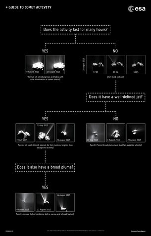
 

Guide to comet activity
 
These violent events were over and above regular jets and flows of material seen streaming from the comet’s nucleus. The latter switch on and off with clockwork repeatability from one comet rotation to the next, synchronised with the rise and fall of the Sun’s illumination.
By contrast, outbursts are much brighter than the usual jets – sudden, brief, high-speed releases of dust. They are typically seen only in a single image, indicating that they have a lifetime shorter than interval between images – typically 5–30 minutes.
A typical outburst is thought to release 60–260 tonnes of material in those few minutes.
On average, the outbursts around the closest approach to the Sun occurred once every 30 hours – about 2.4 comet rotations. Based on the appearance of the dust flow, they can be divided into three categories.
One type is associated with a long, narrow jet extending far from the nucleus, while the second involves a broad, wide base that expands more laterally. The third category is a complex hybrid of the other two.
“As any given outburst is short-lived and only captured in one image, we can’t tell whether it was imaged shortly after the outburst started, or later in the process,” notes Jean-Baptiste Vincent, lead author of the paper published today in Monthly Notices of the Astronomical Society.
“As a result, we can’t tell if these three types of plume ‘shapes’ correspond to different mechanisms, or just different stages of a single process.
"But if just one process is involved, then the logical evolutionary sequence is that an initially long narrow jet with dust is ejected at high speed, most likely from a confined space.
"Then, as the local surface around the exit point is modified, a larger fraction of fresh material is exposed, broadening the plume ‘base’.
"Finally, when the source region has been altered so much as not to be able to support the narrow jet anymore, only a broad plume survives.”
 

Summer outburst sources
 
The other key question is how these outbursts are triggered.
The team found that just over half of the events occurred in regions corresponding to early morning, as the Sun began warming up the surface after many hours in darkness.
The rapid change in local temperature is thought to trigger thermal stresses in the surface that might lead to a sudden fracturing and exposure of volatile material. This material rapidly heats up and vaporises explosively.
The other events occurred after local noon – after illumination of a few hours.
These outbursts are attributed to a different cause, where the cumulative heat makes its down to pockets of ‘volatiles’ buried beneath the surface, again causing sudden heating and an explosion.
“The fact that we have clear morning and noon outbursts points to at least two different ways of triggering an outburst,” says Jean-Baptiste.
But it is also possible that yet another cause is involved in some outbursts.
“We found that most of the outbursts seem to originate from regional boundaries on the comet, places where there are changes in texture or topography in the local terrain, such as steep cliffs, pits or alcoves,” adds Jean-Baptiste.
 

Cliff collapse and comet activity
 
Indeed, the fact that boulders or other debris are also seen around the regions identified as the sources of the outbursts confirms that these areas are particularly susceptible to erosion.
While slowly eroding cliff faces are thought to be responsible for some of the regular, long-lived jet features, a weakened cliff edge may also suddenly collapse at any time, night or day. This collapse would reveal substantial amounts of fresh material and could lead to an outburst even when the region is not exposed to sunlight.
At least one of the events studied took place in local darkness and may be linked to cliff collapse.
“Studying the comet over a long period of time has given us the chance to look into the difference between ‘normal’ activity and short-lived outbursts, and how these outbursts may be triggered,” says Matt Taylor, ESA’s Rosetta project scientist. 
“Studying how these phenomena vary as the comet progresses along its orbit around the Sun give us new insight into how comets evolve during their lifetimes.”

Notes for Editors

“Summer fireworks on Comet 67P,” by J.-B. Vincent et al is accepted for publication in Monthly Notices of the Royal Astronomical Society.
This article also uses information from “Are fractured cliffs the source of cometary dust jets? Insights from OSIRIS/Rosetta at 67P,” by J.-B. Vincent et al, published in Astronomy & Astrophysics 2015
Of the 34 outbursts, 26 were detected with the OSIRIS narrow-angle camera, three with the OSIRIS wide-angle camera, and five with the Navigation Camera.
For further information, please contact:
Jean-Baptiste Vincent
Max Planck Institute for Solar System Research, Gottingen, Germany
Email: vincent@mps.mpg.de
Matt Taylor

ESA Rosetta project scientist

Email: matt.taylor@esa.int
Markus Bauer


ESA Science and Robotic Exploration Communication Officer


Tel: +31 71 565 6799


Mob: +31 61 594 3 954


Email: markus.bauer@esa.int

Related articles


VERSIÓN EN ESPAÑOL  :
 

Emisiones en el cometa

Fuegos artificiales en el verano del cometa

23 septiembre 2016
Las breves pero potentes emisiones vistas en 67P/Churyumov-Gerasimenko durante su periodo de mayor actividad el año pasado han sido analizadas hasta dar con su origen en la superficie del cometa. 
En los tres meses alrededor del 13 de agosto de 2015, fecha del máximo acercamiento del cometa al Sol, las cámaras de Rosetta capturaron 34 emisiones.
 

Guía de la actividad del cometa
 
Estos violentos estallidos iban mucho más allá de los chorros y flujos de materia que suelen salir expulsados del núcleo del cometa. Estos aparecen y desaparecen con precisión cronométrica en cada rotación, sincronizándose con la salida y la puesta del Sol en el cometa.
Por el contrario, las emisiones son mucho más brillantes que los chorros; se trata de breves proyecciones de polvo a alta velocidad. Normalmente solo se llegan a verse en una imagen, lo que indica que su duración es inferior al intervalo de captura, que es de entre 5 y 30 minutos.
Se cree que, en esos pocos minutos, cada emisión puede liberar entre 60 y 260 toneladas de materia.
De media, las emisiones alrededor del máximo acercamiento al Sol se produjeron una vez cada 30 horas, cada 2,4 rotaciones del cometa. Basándonos en la aspecto del flujo de polvo, podemos dividir las emisiones en tres categorías:
La primera se asocia a un chorro largo y estrecho, que se va alejando del núcleo. El segundo tipo de emisión implica una base ancha que se expande más hacia los lados. La tercera categoría muestra un complejo híbrido de los dos tipos anteriores.
“Como las emisiones son tan cortas que solo se capturan en una imagen, no podemos afirmar si una determinada imagen se capturó poco después de comenzar la emisión o más tarde en el proceso —explica Jean-Baptiste Vincent, autor principal del artículo publicado hoy en Monthly Notices of the Astronomical Society—. Así, no podemos saber si estos tres tipos de columna corresponden a distintos mecanismos o si se trata de distintas etapas de un único proceso”.
“No obstante, si se trata de un solo proceso, la secuencia evolutiva lógica sería que un chorro largo y estrecho de polvo se expulsa a alta velocidad, probablemente desde un espacio confinado.
“Después, a medida que cambia la superficie alrededor del punto de partida, un área mayor de materia nueva queda expuesta, ampliándose la ‘base’ de la columna”.
“Finalmente, cuando la región de origen se ha visto alterada hasta el punto de no poder soportar más el chorro, lo único que sobrevive es esa columna más ancha”.
 

Las fuentes de las emisiones veraniegas
 
La otra cuestión clave es qué origina estas emisiones.
El equipo descubrió que algo más de la mitad de estos eventos se producían en regiones correspondientes a la primera hora de la mañana, cuando el Sol comenzaba a calentar la superficie tras varias horas de oscuridad.
Así, se cree que el rápido cambio de la temperatura local provoca unas tensiones térmicas en la superficie que podrían llevar a la fracturación y exposición repentinas de materia volátil. Esta materia se calentaría con rapidez y terminaría por evaporarse de forma explosiva.
El resto de eventos se produjo tras el mediodía local, cuando la superficie había permanecido iluminada varias horas.
Estas emisiones se atribuyen a otra causa: el calor acumulado llegaría a bolsas de componentes volátiles enterrados bajo la superficie, provocando una vez más su calentamiento y estallido repentinos.
“El hecho de que existan puntos de emisión evidentes en la mañana y el mediodía indica, como mínimo, dos desencadenantes distintos para las emisiones”, reconoce Jean-Baptiste.
Pero también es posible que algunas emisiones tengan otra causa.
“Hemos visto que la mayoría de emisiones parecen originarse en los límites regionales del cometa, lugares con cambios en la textura o topografía del terreno local, como acantilados, fosas o nichos”, añade.
 

Derrumbe de acantilados y actividad cometaria
 
Efectivamente, el hecho de que también se aprecien rocas y otros residuos alrededor de estas regiones, identificadas como fuentes de las emisiones, confirma que estas áreas son especialmente susceptibles a la erosión.
Aunque se cree que la lenta erosión de la caras de los acantilados es responsable de algunos de los chorros regulares y más prolongados, el debilitamiento de una de estas paredes también podría provocar su derrumbamiento repentino, de noche o de día. Este derrumbamiento expondría cantidades sustanciales de materia nueva, lo que podría provocar una emisión aunque la región no estuviese expuesta a la luz solar.
Al menos uno de los eventos estudiados se produjo en la oscuridad, y podría deberse al derrumbamiento de uno de estos precipicios.
“El estudio prolongado del cometa nos ha permitido observar la diferencia entre la actividad ‘normal’ y las emisiones de corta duración, así como sus posibles desencadenantes”, aclara Matt Taylor, científico del proyecto Rosetta de la ESA. 
“Al analizar cómo estos fenómenos varían a medida que el cometa recorre su órbita alrededor del Sol obtenemos nuevos datos sobre la evolución de los cometas a lo largo de su vida”.

Nota para los editores

“Summer fireworks on Comet 67P”, de J.-B. Vincent et al., está publicado en Monthly Notices of the Royal Astronomical Society.
El presente documento también utiliza información procedente de “Are fractured cliffs the source of cometary dust jets? Insights from OSIRIS/Rosetta at 67P”, de J.-B. Vincent et al., publicado en Astronomy & Astrophysics en 2015.
De las 34 emisiones, 26 fueron detectadas con el teleobjetivo de OSIRIS, tres con la cámara de gran angular y otras cinco con la cámara de navegación
 
Para más información:
Jean-Baptiste Vincent
Max Planck Institute for Solar System Research, Gottingen, Alemania
Correo electrónico: vincent@mps.mpg.de
Matt Taylor

ESA Rosetta project scientist

Correo electrónico: matt.taylor@esa.int
Markus Bauer


ESA Science and Robotic Exploration Communication Officer


Teléfono: +31 71 565 6799


Móvil: +31 61 594 3 954


Correo electrónico: markus.bauer@esa.int

ESA
Guillermo Gonzalo Sánchez Achutegui
Inscríbete en el Foro del blog y participa : A Vuelo De Un Quinde - El Foro!

sábado, 24 de septiembre de 2016

NASA : NASA's IceBridge Observes Effects of Summer Melt on Greenland Ice Sheet .- IceBridge de la NASA Observa Efectos de verano que derriten hielo de Groenlandia

http://www.nasa.gov/image-feature/nasas-icebridge-observes-effects-of-summer-melt-on-greenland-ice-sheet

Sunglint on Greenland glacier
NASA's IceBridge, an airborne survey of polar ice, flew over the Helheim/Kangerdlugssuaq region of Greenland on Sept. 11, 2016. This photograph from the flight captures Greenland's Steenstrup Glacier, with the midmorning sun glinting off of the Denmark Strait in the background. IceBridge completed the final flight of the summer campaign to observe the impact of the summer melt season on the ice sheet on Sept. 16. 
The IceBridge flights, which began on Aug. 27, are mostly repeats of lines that the team flew in early May, so that scientists can observe changes in ice elevation between the spring and late summer. For this short, end-of-summer campaign, the IceBridge scientists flew aboard an HU-25A Guardian aircraft from NASA's Langley Research Center in Hampton, Virginia.
Image Credit: NASA/John Sonntag
Last Updated: Sept. 16, 2016
Editor: Sarah Loff
Tags:  Earth, Ice, IceBridge, Image of the Day,
NASA
Guillermo Gonzalo Sánchez Achutegui
ayabaca@gmail.com
ayabaca@hotmail.com
ayabaca@yahoo.com
Inscríbete en el Foro del blog y participa : A Vuelo De Un Quinde - El Foro!

domingo, 19 de junio de 2016

NSF: Future summers could be hotter than any on record .- Los veranos futuros podrían ser más caliente que cualquier constancia

Hola amigos: A VUELO DE UN QUINDE EL BLOG., hemos recibido información de la Fundación Nacional de Ciencias de Los Estados Unidos, sobre el calentamiento del clima en los próximos años; NSF, NOS DICE: ... "Si el cambio climático continúa en su trayectoria actual, la probabilidad de que los veranos entre 2061 y 2080 será más caliente que el más caliente registrado se sitúa en el 80 por ciento a través de áreas de tierra del mundo, excluyendo la Antártida, que no fue estudiado.
Si se reducen las emisiones de gases de efecto invernadero, sin embargo, que la probabilidad se reduce a 41 por ciento.
"Veranos extremadamente calientes siempre suponen un reto para la sociedad", dijo el científico del NCAR Flavio Lehner, autor principal del estudio. "Ellos pueden aumentar el riesgo de problemas de salud, y también pueden dañar los cultivos y profundizar las sequías. Tales veranos son una verdadera prueba de nuestra capacidad de adaptación al aumento de las temperaturas."
El estudio es parte de un número especial de la revista Cambio Climático que se centrará en la cuantificación de los beneficios de reducir las emisiones de gases de efecto invernadero. La investigación fue financiada por la Fundación Nacional de Ciencias de EE.UU. (NSF) y la Fundación Nacional de Ciencia de Suiza................"
More information..........

Reducing carbon emissions could cut risk of record-breaking summertime heat in half

Heat waves effects
Heat waves affect energy use, farming and other aspects of society.
Credit and Larger Version
June 13, 2016
This is part 17 in a series on NSF's geosciences risk and resilience interest area. Please see parts one, two, three, four, five, six, seven, eight, nine, 10, 11, 12, 13, 14, 15 and 16.
In 50 years, summers across most of the globe could be hotter than any summer experienced by people to date, according to a study by scientists at the National Center for Atmospheric Research (NCAR) in Boulder, Colo.
If climate change continues on its current trajectory, the probability that summers between 2061 and 2080 will be warmer than the hottest on record stands at 80 percent across the world's land areas, excluding Antarctica, which was not studied.
If greenhouse gas emissions are reduced, however, that probability drops to 41 percent.
"Extremely hot summers always pose a challenge to society," said NCAR scientist Flavio Lehner, lead author of the study. "They can increase the risk for health issues, and can also damage crops and deepen droughts. Such summers are a true test of our adaptability to rising temperatures."
The study is part of an upcoming special issue of the journal Climatic Change that will focus on quantifying the benefits of reducing greenhouse gas emissions. The research was funded by the U.S. National Science Foundation (NSF) and the Swiss National Science Foundation.
 
Simulating a range of summers
 
The research team, which includes NCAR scientists Clara Deser and Benjamin Sanderson, used two existing sets of model simulations to investigate what future summers might look like.
They created both by running the NCAR-based Community Earth System Model 15 times, with one simulation assuming that greenhouse gas emissions remain unabated and the other assuming that society reduces emissions.
NSF and the U.S. Department of Energy fund the Community Earth System Model. The team ran the simulations on the NCAR-Wyoming Supercomputing Center's Yellowstone system.
"We've thought of climate change as 'global warming,' but it's important to understand how this overall warming affects conditions that hit people locally," said Eric DeWeaver, program director in NSF's Division of Atmospheric and Geospace Sciences, which funds NCAR.
"Extreme temperatures pose risks to people around the globe," DeWeaver said. "These scientists show the power of ensembles of simulations for understanding how these risks depend on the level of greenhouse gas emissions."
By using simulations created by running the same model multiple times, with only tiny differences in the initial starting conditions, the scientists could examine the range of expected summertime temperatures for future "business-as-usual" and reduced-emissions scenarios.
"This is the first time the risk of record summer heat and its dependence on the rate of greenhouse gas emissions have been so comprehensively evaluated from a large set of simulations with a single state-of-the-art climate model," Deser said.
The scientists compared results to summertime temperatures recorded between 1920 and 2014 and to 15 sets of simulated summertime temperatures for the same period.
By simulating past summers -- instead of relying solely on observations -- the researchers established a large range of temperatures that could have occurred naturally under the same conditions, including greenhouse gas concentrations and volcanic eruptions.
"Instead of just comparing the future to 95 summers from the past, the models give us the opportunity to create more than 1,400 possible past summers," Lehner said. "The result is a more comprehensive look at what should be considered natural variability and what can be attributed to climate change."
 
Emissions cuts could yield big benefits
 
The results show that between 2061 and 2080, summers in large parts of North and South America, central Europe, Asia, and Africa have a greater than 90 percent chance of being warmer than any summer in the historic record if emissions continue unabated.
That means virtually every summer would be as warm as the hottest to date.
In some regions, the likelihood of summers being warmer than any in the historical record remained less than 50 percent, but in those places -- including Alaska, the central U.S., Scandinavia, Siberia and continental Australia -- summer temperatures naturally vary greatly, making it more difficult to detect effects of climate change.
Reducing emissions would lower the global probability of future summers that are hotter than any in the past, but would not result in uniformly spread benefits. In some regions, including the U.S. East Coast and large parts of the tropics, the probability would remain above 90 percent, even if emissions were reduced.
But reduced emissions would result in a sizable boon for other regions of the world.
Parts of Brazil, central Europe, and eastern China would see a reduction of more than 50 percent in the chance that future summers would be hotter than the historic range. Since these areas are densely inhabited, a large part of the global population would benefit significantly from climate change mitigation.
"It's often overlooked that the majority of the world's population lives in regions that will see a comparably fast rise in temperatures," Lehner said.
-NSF-
Media Contacts Cheryl Dybas, NSF, (703) 292-7734,
cdybas@nsf.gov
Laura Snider, NCAR, (303) 497-8605,
 lsnider@ucar.edu


The National Science Foundation (NSF) is an independent federal agency that supports fundamental research and education across all fields of science and engineering. In fiscal year (FY) 2016, its budget is $7.5 billion. NSF funds reach all 50 states through grants to nearly 2,000 colleges, universities and other institutions. Each year, NSF receives more than 48,000 competitive proposals for funding and makes about 12,000 new funding awards. NSF also awards about $626 million in professional and service contracts yearly.
 Get News Updates by Email 
Useful NSF Web Sites:
NSF Home Page:
http://www.nsf.gov
NSF News:
 http://www.nsf.gov/news/
For the News Media:
http://www.nsf.gov/news/newsroom.jsp
Science and Engineering Statistics:
 http://www.nsf.gov/statistics/
Awards Searches:
http://www.nsf.gov/awardsearch/
How hot will future summers be? According to new research, a lot hotter than in the past.
Credit and Larger Version
heat waves
The summer of 2012, among others, was a scorcher. In 2012, three summer heat waves struck the U.S.
Credit and Larger Version
Heat Map of the US - June 29, 2012
June 29, 2012, was the hottest day that year in the eastern U.S.
Credit and Larger Version
The urban heat island effect
The urban heat island effect further raises summer temperatures in cities.
Credit and Larger Version
Grasses turn sere and brown in baking summer sun.
Credit and Larger Versión
the U.S. National Science Foundation (NSF)
Guillermo Gonzalo Sánchez Achutegui
ayabaca@gmail.com
ayabaca@hotmail.com
ayabaca@yahoo.com
Inscríbete en el Foro del blog y participa : A Vuelo De Un Quinde - El Foro!

martes, 17 de junio de 2014

nsf.gov - National Science Foundation - Summer brings crab feasts--and concerns for Chesapeake blue crabs


Infectious diseases play a part in crab population declines
blue crab with the text photo gallery
View scientists doing blue crab research on Chesapeake Bay.
Credit and Larger Version
June 17, 2014
The following is part nine in a series on the NSF-NIH Ecology and Evolution of Infectious Diseases (EEID) Program. See parts: one, two, three, four, five, six, seven and eight.
It's almost summer. Seafood restaurants from coast-to-coast are serving platter after platter of steaming crabs, ready for hammering and picking. The supply seems endless, but is it?
Not if we're talking about blue crabs from Chesapeake Bay.
The bay's iconic blue crab population has dropped to levels not seen since before restrictions were placed on the fishery more than five years ago. What's to blame?
A long and, by Mid-Atlantic standards, brutal winter has been fingered as one culprit. In one of the worst die-offs in recent history, more than a quarter of the Chesapeake's blue crabs perished in the frigid waters.
 
More than cold water to blame
But that's not the only factor, says disease ecologist Jeff Shields of the Virginia Institute of Marine Sciences in Gloucester Point, Va.
"Several commercially important crustacean populations, including blue crabs, have had declines linked to diseases," says Shields. "In most cases, though, the underlying causes have been difficult to pinpoint because crustacean pathogens [infectious agents] aren't very well known."
To help determine what's infecting Chesapeake blue crabs and other crustaceans, the National Science Foundation (NSF) awarded Shields a grant through the joint NSF-NIH Ecology and Evolution of Infectious Diseases Program.
"We know very little about how disease affects populations of marine invertebrates and even less about how disease might interact with other stressors, such as overfishing," says Dave Garrison, director of NSF's Biological Oceanography Program, which also funded the research.
"This study is a major step toward discovering new ways of wisely managing our coastal resources."
One Chesapeake Bay blue crab killer may be a single-celled parasitic dinoflagellate named Hematodinium, a scourge that infects blue crabs and is of concern in fisheries not only in the Chesapeake, but around the world.
 
Outbreak in the crab pot and the shedding house
The parasite was first reported along the U.S. East Coast in the 1970s and found in the Chesapeake's blue crabs in the 1990s.
In a Hematodinium outbreak, some 50 percent of crabs caught in fishing pots may die. That number jumps to 75 percent in "shedding houses" where crabs molt their shells, then are collected for the soft-shell industry.
"Infection is almost always fatal--for the crabs," says Shields, who adds that the disease isn't harmful to humans.
In a breakthrough for blue crabs, Shields and colleagues recently succeeded in their effort to uncover the life history of Hematodinium.
"Describing the entire life cycle of Hematodinium is an important step toward controlling the infection," says Shields. "With all the parasite's stages in culture in the lab, we can learn when Hematodinium is most infectious."
The biologists made their discovery by looking at many parasite generations over a year-long period.
 
Answers under a microscope
Through the research, scientists now know that Hematodinium takes some 40 to 50 days to develop. "That matches what we see in the field," he says. "We think infection is linked with blue crabs' molting cycles."
Hematodinium usually infects young crabs. Some 50 to 70 percent of juvenile blue crabs along the Virginia coast carry the pathogen, "and it's prevalent in bays and inlets along the entire U.S. East Coast," says Shields.
The high cost--to the crab population and to the humans that depend on it--comes in the deaths of young blue crabs before they can make their way from coastal spawning grounds to brackish tributaries, where they become large enough to legally catch.
"Imagine a harvest with 50 percent more crabs," says Shields. "The toll exacted by Hematodinium is very clear."
The parasite is after more than blue crabs, however.
"You can't fish out the blue crabs somewhere and hope this pathogen will be gone," says Shields. "It's also in many other crustaceans, including spider crabs, rock crabs and other swimming crabs."
 
Insights from the bay's shape
Outbreaks of Hematodinium are linked with certain geographic features, such as shallow bays, lagoons and fjords. "Such features are ideal for the growth and spread of pathogens, as they serve to focus transmissive stages or retain them within the system," writes Shields in a paper published in the Journal of Invertebrate Pathology.
Four factors may facilitate epidemics of Hematodinium and other pathogens: relatively "closed" host (crab) populations, with little immigration and emigration of juveniles and adults; bays with restricted water exchange with the open ocean, which hold in pathogens; stressful environmental conditions, such as overfishing and seasonal hypoxia, or "dead zones"; and pathogens that can rapidly multiply.
"The Chesapeake has several of these features," Shields says.
 
Managing for pathogens
Shields and colleagues are working to understand how Hematodinium is transmitted in wild crustacean populations and at shrimp farms and other aquaculture operations. "We hope to develop 'best practices' for managing, in particular, the Chesapeake's wild blue crabs."
Diseases can have serious effects on commercial fisheries, Shields says. "But there's a perception among resource managers and fishers that diseases aren't important to the fishing industry, or that little can be done to manage them."
Too few fishery models use information like disease prevalence and distribution, according to Shields, and fisheries management decisions often don't consider disease.
"Estimates of disease-induced effects such as mortality or 'negative marketability' can be incorporated into existing models to improve stock assessment and management," Shields writes in the Journal of Invertebrate Pathology.
Disease may be the sleeper in the decline of the Chesapeake Bay blue crab.
Hard-hit by freezing temperatures, low-oxygen waters and overfishing, unless disease is taken into account, believes Shields, the next blue crabs caught may be headed not to your dinner table, but to the crustacean equivalent of the ICU.
-- Cheryl Dybas, NSF (703) 292-7734 cdybas@nsf.gov
Investigators Harry Wang
Kimberly Reece
Jeffrey Shields
Related Institutions/Organizations College of William & Mary Virginia Institute of Marine Science
Related Programs Biological Oceanography
Total Grants $2,110,161
Related WebsitesNSF Special Report: The Ecology and Evolution of Infectious Diseases:
blue crab in person's hands
Chesapeake Bay blue crabs are in decline: How much does disease play a part?
Credit and Larger Version
salt marshes on the Eastern Shore of the Delmarva Peninsula.
Domain of the Chesapeake blue crab: salt marshes on the Eastern Shore of the Delmarva Peninsula.
Credit and Larger Version
researchers with crab samples in a boat at sea
Juvenile blue crabs are collected in shallow seagrass beds, then sorted for transport to the lab.
Credit and Larger Version
Scientists Jeff Shields and Anna Coffey of VIMS pull a crab pot from the water
Scientists Jeff Shields and Anna Coffey of VIMS pull a crab pot and sort crabs into coolers.
Credit and Larger Version
Two mature male blue crabs with the distinctive color of their claws and walking legs.
Two mature male blue crabs show the distinctive color of their claws and walking legs.
Credit and Larger Version
researcher taking blood from the base of a walking leg of a blue crab using a syringe
Hemolymph, or blood, is taken from the base of a walking leg of a blue crab.
Credit and Larger Versión
the National Science Foundation(NSF),
Guillermo Gonzalo Sánchez Achutegui

domingo, 23 de junio de 2013

nsf.gov - Discovery - Summertime: Hot Time in the City

Parks are islands of coolness in cities' urban heat.-
Photo of sun radiating over highway filled with cars in traffic in Phoenix
In summer, extreme heat events are on the way in cities like Phoenix.
Credit: NSF Central-Arizona Phoenix LTER Site
Download the high-resolution JPG version of the image. (100 KB)
Illustration showing how temperatur is higher over urban envrionments compared to rural
The 'urban heat island effect' raises temperatures in cities compared with surrounding areas.
Credit: NASA
Download the high-resolution JPG version of the image. (103 KB) 

People ine Sherman Park, in a low-income Phoenix neighborhood, with very few trees
Sherman Park, part of a low-income Phoenix neighborhood in need of green spaces.
Credit: Sharon Harlan
Download the high-resolution JPG version of the image. (4.9 MB)
Map of vegetation (red), soil (brown, tan), built materials (white) in a south Phoenix neighborhood.
Vegetation (red), soil (brown, tan), built materials (white) in a south Phoenix neighborhood.
Credit: NASA
Download the high-resolution JPG version of the image. (9.8 MB)
Researchers Chris Martin, Darrel Jenerette (background) conducting field work in Phoenix.
Credit: Sharon Harlan
Download the high-resolution JPG version of the image. (5.2 MB)
Heat map of Chicago skyline
Across the nation and around the world, urban areas are heating up.
Credit: Dustin Phillips/Creative Commons
Download the high-resolution JPG version of the image. (112 KB)

The following is part ten in a series on the National Science Foundation's Science, Engineering and Education for Sustainability (SEES) investment. Visit parts one, two, three, four, five, six, seven, eight and nine in this series.
It's the first day of summer, a hot time in the desert city of Phoenix. And in cities across the United States--and the Northern Hemisphere.
Heat islands, as these urban hot spots are called, are metropolitan areas significantly warmer than surrounding rural areas. Why?
"Us," says sociologist Sharon Harlan of Arizona State University (ASU). "It's all due to the effects of humans. We've modified the surface of the land in ways that retain heat."
Urban heat islands are the result. Soil and grass have been replaced with materials such as asphalt and concrete that absorb heat during the day and re-radiate it at night, causing higher temperatures. 

Summer in a blistering desert
Harlan and colleagues in fields across the social, natural and health sciences are studying urban heat islands--and their opposites, park cool islands where plant growth throws cold water on burning temperatures.
They're conducting the research via a National Science Foundation (NSF) Coupled Natural and Human Systems (CNH) grant. CNH is one of NSF's Science, Engineering and Education for Sustainability, or SEES, programs.
"Cities can be hot and uncomfortable places for the people who live in them, with some populations especially vulnerable to health problems from urban heat," says Sarah Ruth, CNH program director in NSF's Directorate for Geosciences.
"The city environment and its human inhabitants form a complex system with multiple connections. These researchers have uncovered important information about this system and the interactions among its components.
"The results suggest ways city officials and residents can work together to create places where fewer people suffer the effects of extreme temperatures."
The hot, arid Sonoran Desert is central Arizona's natural environment. Humans have transformed the desert over thousands of years, beginning with early Native American subsistence farmers and continuing with late 19th century Anglo-American commercial growers and 20th century sunbelt migrants.
Metropolitan Phoenix is an ideal laboratory for investigating heat-related human vulnerability, says Harlan. Rapid urbanization has replaced natural vegetation and agricultural fields, increasing summer temperatures during the past 50 years.

Islands of green
What's one of the answers? Park cool islands, found the scientists.
They evaluated the effects of plants' cool greenness on a Phoenix inner-city park.
The results were recently published in the journal Urban Ecosystems. Along with Harlan, co-authors of the paper, all from ASU, are Juan Declet-Barreto, Anthony Brazel, Chris Martin and Winston Chow.
They're also working through the NSF Central Arizona-Phoenix Long-Term Ecological Research (LTER) site, one of 26 such NSF LTER sites across the nation and around the world.
"We predicted air and surface temperatures under two different vegetation regimes: existing conditions representative of Phoenix urban core neighborhoods, and a scenario using principles of landscape design and architecture, and urban heat island mitigation strategies," write the scientists.
They found that the air beneath and around "canopied vegetation"--trees--was cooler than the surroundings.
Larger plants such as trees absorb and reflect the Sun's rays, buffering the heat index. Scientists call it a "microclimate ecosystem service," better known as, simply, shade.
Trees also reduce hot air by turning water from liquid to gas inside their leaves. "Temperatures then fall in the immediate environment," says Martin.
It all adds up to a park cool island. "Park cool islands are usually found in irregular patterns in a city," Declet-Barreto says. "They're nested within warmer spots."

The Latino Urban Core
The team studied the role of park cool islands in a low-income, ethnic minority community in inner-city Phoenix.
The area is called the Latino Urban Core. It's bounded by industrial land to the north, south and east and an interstate highway to the west. The neighborhood's main feature is an electric utility company easement currently used as "linear park space almost entirely devoid of vegetation," states the Urban Ecosystems paper.
The Latino Urban Core's sparse vegetation is mostly in residents' yards. Patches of exposed soil with nothing growing on them are scattered across vacant lots, yards, and the grounds of the "linear park."
Parks in low-income neighborhoods tend to be hotter than parks in higher-income areas, research has shown. Although residents in low-income areas need places to cool off, these neighborhoods have less inherent cooling capacity as there's less green space.
Inner-city green space--lacking in Phoenix's Latino Urban Core--is a crucial component of urban heat island mitigation, Declet-Barreto says. "But it's made more difficult by ongoing debates over urban amenities like parks and the needed resources, such as water, tax dollars, local government will and regular maintenance."
"Ecologies of fear" often arise in neglected green spaces. "They're legacies of environmental and racial discrimination, inner-city decay and a continuing urban planning focus on fringe [suburban] development," write the researchers.
Studies have shown that in Phoenix, inner-city areas bear higher property tax burdens in comparison with suburbs, but the former receive significantly fewer tax dollars for parks, recreation and water supplies.
Minority and low-income communities are increasingly addressing such disparities by demanding a more equitable distribution of urban amenities, such as green spaces like parks.
In low-income communities, parks are often the only available public gathering places. Green spaces, scientists say, can provide cultural, social and--more directly applicable to extreme heat mitigation--human health and ecological benefits.

Cooling down urban heat islands
Finding ways to offset National Science Foundation (NSF)high temperatures in desert cities where the weather is chronically hot, says Harlan, is critical.
Extreme heat, scientists have found, is a threat to human health, increases atmospheric pollutants and energy and water use, alters regional hydrology and affects interactions between humans and ecological processes.
"The problem of heat-related deaths and illnesses is very serious," says Harlan. "Each year, heat fatalities in the U.S. happen in greater numbers than mortality from any other type of weather disaster." High heat wave events--unexpected and long-duration heat waves--are becoming more common in cities like Phoenix, Chicago and Paris.
Climate change and rapidly growing cities are likely to fuel more such events.
"Our research suggests that climate intervention strategies should be targeted at the neighborhoods and population groups that are most vulnerable to environmental hazards like extreme heat events," says Harlan. "We hope our results will be used in better decision-making about climate adaptation in cities."
Greening parks is an intervention strategy, she says, for urban heat island mitigation that could be supported with public resources.
"If targeted to low-income neighborhoods where vulnerability to heat is greater," says Harlan, "it would address an environmental inequity and provide better ecosystem services for these neighborhoods."
One antidote to an urban heat island, it turns out, is another island, a place filled with shade trees and lush growth: a park cool island.
--  Cheryl Dybas, NSF (703) 292-7734   cdybas@nsf.gov
Related Websites
NSF Science, Engineering and Education for Sustainability Programs:
 http://www.nsf.gov/sees
NSF Publication: Discoveries in Sustainability: 
http://www.nsf.gov/pubs/2012/disco12001/disco12001.pdf
NSF News Release: National Science Foundation Awards Grants for Research on Coupled Natural and Human Systems:

 The National Science Foundation (NSF).-
 Guillermo Gonzalo Sánchez Achutegui
ayabaca@gmail.com
ayabaca@hotmail.com
ayabaca@yahoo.com
Inscríbete en el Foro del blog y participa : A Vuelo De Un Quinde - El Foro!

sábado, 18 de agosto de 2012

Discovery: From Lake to Land, in a Land of Lakes

Hi My Friends: A VUELO DE UN QUINDE EL BLOG., Moose act as conduits of nitrogen between water bodies and the edges of lakes, ponds
 Isle Royale is a perfect place for moose: water in every direction; shores lined with pondweed, water lilies and other aquatic vegetation upon which moose feed; and nearby forests laden with other favored moose foods like the buds and twigs of willow, aspen, red dogwood and balsam fir trees.
Credit: John Vucetich
 Scientists have studied moose and wolves on Isle Royale in Lake Superior for five decades.
Credit: John Vucetich
 Aquatic macrophytes--large plants of lakes and ponds--are important in a moose's diet.
Credit: John Vucetich
 The shores of Isle Royale are lined with the vegetation moose prefer.
Credit: John Vucetich
 Ojibwe refer to the moose as "mooz," or "twig eater," for good reason.
Credit: John Vucetich
 Briefly interrupted in a twig dinner, a moose surveys Isle Royale's landscape.
Credit: John Vucetich

This article is the fourth in a series on NSF's Long Term Research in Environmental Biology (LTREB) awards. Visit parts one, two and three.
What animal can see only a limited distance, has no top front teeth, and prefers shady, wet areas such as bogs and marshes?
If you guessed a moose, Alces alces, you'd be correct.
When summer or autumn travels take you through northern regions dotted with lakes and ponds, you may glimpse this creature, water dripping from its bell--the flap of skin under its throat. It's most often visible in early morning and at dusk, and in low, wet areas.
Like many of us, moose don't like hot weather. They overheat at summer temperatures above 59 degrees Fahrenheit (15 degrees Celsius). So, on hot days they take to the waters--the edges of wet bogs lined with shade trees.
What moose find there is of interest to ecologists Joseph Bump, Rolf Peterson and John Vucetich of Michigan Technological University.
With funding from the National Science Foundation (NSF), the scientists study relationships between moose, wolves and the environment on a remote island in Lake Superior called Isle Royale. The project has been ongoing for five decades.
Isle Royale is a perfect place for moose: water in every direction; shores lined with pondweed, water lilies and other aquatic vegetation upon which moose feed; and nearby forests laden with other favored moose foods like the buds and twigs of willow, aspen, red dogwood and balsam fir trees.
Moose live in the northern areas of North America, Europe and Eurasia in the cold climates of mixed deciduous-coniferous forests.  They're the northern forest's largest herbivores.
Each moose chomps down about three million bites of shrubs and trees and eats three metric tons of leaves and twigs every year. The Ojibwe people, Native Americans long familiar with the animal, call it "mooz," meaning "twig eater."
A typical moose, which weighs almost 800 pounds, may eat up to 70 pounds of food each day. The average adult moose consumes some 9,770 calories per day to maintain its body weight.
Some of a moose's energy comes from vegetation that grows on land, but many land-based plants are low in sodium. The larger plants of lakes, ponds and wetlands, known as aquatic macrophytes, provide moose with the sodium they need. As much as half a moose's diet consists of aquatic macrophytes.
Where do the remains from all this foraging wind up?
They come ashore, according to research conducted by Bump, Peterson and Vucetich, along with Keren Tischler of Common Coast Research & Conservation in Hancock, Mich., and Amy Schrank of the University of Michigan Biological Station.
When moose forage on aquatic macrophytes, which are also rich in nitrogen, then make their way onto land, they're acting as a conduit for the plants' nitrogen. Spots in which moose excrete waste, and where they die, are direct routes from water-to-land for this element.
"Moose transfer significant amounts of aquatic-derived nitrogen to terrestrial [on land] ecosystems," says Bump. "They greatly increase nitrogen in riparian, or shoreline, zones."
The scientists looked at how this process happens by analyzing data on moose densities, foraging parameters, excretion models and moose carcass locations. They published the results in a paper in the Journal of Animal Ecology.
"Nutrients in salmon, birds, river otters, insects and other animals play a major role in linking aquatic and terrestrial ecosystems," says Bump.
Predators also influence that nutrient transfer. On Isle Royale, when moose are killed by wolves, what's left of their bodies decomposes, transferring nitrogen from the aquatic plants the moose once ate to the land that ultimately lies beneath them.
"It's hard to imagine what species as diverse as moose, salmon and midges, for example, might have in common," says Saran Twombly, program director in NSF's Division of Environmental Biology, which funded the research.
"Yet all three transfer significant quantities of nutrients from aquatic to terrestrial habitats. On Isle Royale, wolves add to this total amount. They kill moose in specific locations and generate 'hotspots' where nitrogen is transferred from lake to shore."
Moose first arrived on Isle Royale in the early 1900s and increased rapidly in what was once a predator-free environment.  Then wolves found their way to the island in the late 1940s; they crossed a winter ice bridge that connected Isle Royale with mainland Ontario. "The lives of Isle Royale moose would never be the same," says Vucetich.
The island's moose population is usually between 700 and 1,200 animals. Wolves there, now down to nine, at times have reached nearly 50.
Isle Royale's moose increase soil nutrients and microbial biomass, change soil microbial composition and increase nitrogen in plants near kill sites for at least two or three years after a moose's death.
"It's clear that moose link aquatic macrophytes with terrestrial animal and microbial communities," says Vucetich.  "Our analysis of long-term carcass patterns--where moose die--shows exactly where such food web links occur on the landscape.
"Given the circumpolar extent of moose, they and the wolves that prey upon them are an important aquatic-terrestrial resource vector in northern ecosystems."
 The National Science Foundation (NSF)
 Related WebsitesMoose & Wolves of Isle Royale: http://www.isleroyalewolf.org
All About Moose: http://www.isleroyalewolf.org/overview/overview/moose.html


Guillermo Gonzalo Sánchez Achutegui
ayabaca@gmail.com
ayabaca@hotmail.com
ayabaca@yahoo.com
 Inscríbete en el Foro del blog y participa : A Vuelo De Un Quinde - El Foro!

domingo, 2 de enero de 2011

PERUVIAN TOURISM: NORTHERN BEACHES LOVERS TO ENJOY WARM WEATHER THIS YEAR 2011

Hi my Friends: A VUELO DE UN QUINDE EL BLOG., The Peruvian North inside his territory encuentrana some of the most beautiful beaches of this part of the coast: Máncora, El Ñuro, Punta Sal, Los Organos, Puerto Pizarro, Cabo Blanco, Pimentel, Colán, etc. Friends of the whole world, we invite them to visit Peru and to enjoy the Sun in the northern beaches, they are so beautiful as any place of the Islands of Hawaii. Friends of the whole world if you are lovers of eating the best food and more exquisite, can savour it in the Peruvian north. Friends of the whole world we invite to have a good time and enjoy the Sun, all this summer in the beaches of the Peruvian north. Friends of The United States of America, Canada, Europe, we are waiting for them in the beaches of the Peruvian north to enjoy the best climate of the world in this summer. Friends of The United States of America specially of the north as from the State of Minnesota and from Minneapolis's city do not suffer with so much cold, only take his plane and we wait for them in the Peruvian north to enjoy the best climate of the world. Máncora: It is located in It Was Felling 238 kms. of Piura. It possesses beautiful beaches as the Pocitas, semicircular, broad beach and of calm waters. The name they take of the puddles that are formed when the sea moves back. The source of information of the image is: regionpiura.gob.pe
Máncora a beautiful city and beach of the Peruvian north dresses from " The Faro ". The source of information of the image is: enMancora.com

Máncora in the inlet of the same name, to 180 Kms. de Piura. The beach has form of half moon and his soil is constituted by thin sand. His waters are calm but in the south sector it is possible to practise Hawaiian table since the movement of the waters is continuous.The source of information of the image is: enMancora.com
Northern beaches lovers to enjoy warm weather this year:
Lima, Jan. 02 (ANDINA). Bathers in Tumbes, Piura and Lambayeque will enjoy high temperatures of nearly 30 degrees Celsius in northern beaches on first days of next year, National Meteorological Agency (Senamhi) reported Friday.

“It is a tendency northern Peru will see this weekend. Sea water is still cold so the area will experience cloudy mornings these days ,” meteorologist stated to Andina News Agency.

Moreover, there will be early morning mist and cold sensation in southern Lima beaches, between Cañete and Pisco, so that bathers should bring warm clothes.

On the other hand, the weather in Arequipa beaches, southern Peru, will be excellent. The same situation will occur in Moquegua and Tacna, Senamhi added.
The source of information is: ANDINA.
Guillermo Gonzalo Sánchez Achutegui

Mi lista de blogs